Note:
The expiration time in the watch graphic is amended if the watch is
replaced, cancelled or extended.
Note:
Note:
The expiration time in the watch graphic is amended if the watch is
replaced, cancelled or extended.
Note: Click for
Watch Status Reports.
SEL0
URGENT - IMMEDIATE BROADCAST REQUESTED
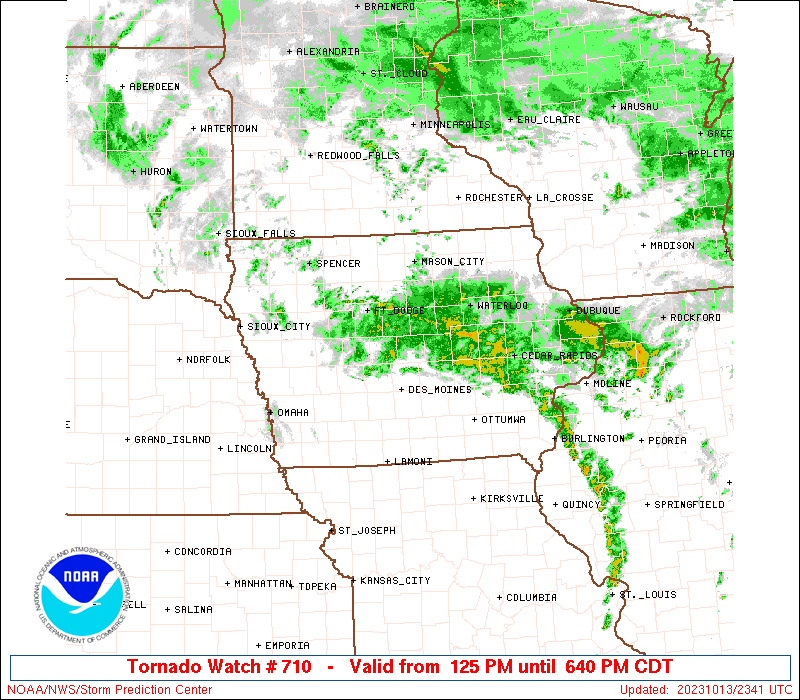
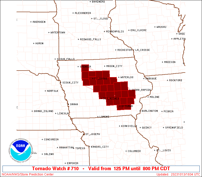
Tornado Watch Number 710
NWS Storm Prediction Center Norman OK
125 PM CDT Fri Oct 13 2023
The NWS Storm Prediction Center has issued a
* Tornado Watch for portions of
Central into southeast Iowa
* Effective this Friday afternoon and evening from 125 PM until
800 PM CDT.
* Primary threats include...
A few tornadoes possible
Isolated damaging wind gusts to 60 mph possible
Isolated large hail events to 1 inch in diameter possible
SUMMARY...Scattered low-topped thunderstorms will form this
afternoon along a slow-moving front across central Iowa. The storm
environment will favor of mix of multicells and some supercells
capable of producing a few tornadoes, along with isolated marginally
severe hail and wind gusts.
The tornado watch area is approximately along and 35 statute miles
north and south of a line from 35 miles west northwest of Fort Dodge
IA to 30 miles south of Cedar Rapids IA. For a complete depiction of
the watch see the associated watch outline update (WOUS64 KWNS
WOU0).
PRECAUTIONARY/PREPAREDNESS ACTIONS...
REMEMBER...A Tornado Watch means conditions are favorable for
tornadoes and severe thunderstorms in and close to the watch
area. Persons in these areas should be on the lookout for
threatening weather conditions and listen for later statements
and possible warnings.
&&
AVIATION...Tornadoes and a few severe thunderstorms with hail
surface and aloft to 1 inch. Extreme turbulence and surface wind
gusts to 50 knots. A few cumulonimbi with maximum tops to 350. Mean
storm motion vector 18020.
...Thompson
   SEL0

   URGENT - IMMEDIATE BROADCAST REQUESTED
   Tornado Watch Number 710
   NWS Storm Prediction Center Norman OK
   125 PM CDT Fri Oct 13 2023

   The NWS Storm Prediction Center has issued a

   * Tornado Watch for portions of
     Central into southeast Iowa

   * Effective this Friday afternoon and evening from 125 PM until
     800 PM CDT.

   * Primary threats include...
     A few tornadoes possible
     Isolated damaging wind gusts to 60 mph possible
     Isolated large hail events to 1 inch in diameter possible

   SUMMARY...Scattered low-topped thunderstorms will form this
   afternoon along a slow-moving front across central Iowa.  The storm
   environment will favor of mix of multicells and some supercells
   capable of producing a few tornadoes, along with isolated marginally
   severe hail and wind gusts.

   The tornado watch area is approximately along and 35 statute miles
   north and south of a line from 35 miles west northwest of Fort Dodge
   IA to 30 miles south of Cedar Rapids IA. For a complete depiction of
   the watch see the associated watch outline update (WOUS64 KWNS
   WOU0).

   PRECAUTIONARY/PREPAREDNESS ACTIONS...

   REMEMBER...A Tornado Watch means conditions are favorable for
   tornadoes and severe thunderstorms in and close to the watch
   area. Persons in these areas should be on the lookout for
   threatening weather conditions and listen for later statements
   and possible warnings.

   &&

   AVIATION...Tornadoes and a few severe thunderstorms with hail
   surface and aloft to 1 inch. Extreme turbulence and surface wind
   gusts to 50 knots. A few cumulonimbi with maximum tops to 350. Mean
   storm motion vector 18020.

   ...Thompson
 Note:
The Aviation Watch (SAW) product is an approximation to the watch area.
The actual watch is depicted by the shaded areas.
Note:
The Aviation Watch (SAW) product is an approximation to the watch area.
The actual watch is depicted by the shaded areas.
   SAW0
   WW 710 TORNADO IA 131825Z - 140100Z
   AXIS..35 STATUTE MILES NORTH AND SOUTH OF LINE..
   35WNW FOD/FORT DODGE IA/ - 30S CID/CEDAR RAPIDS IA/
   ..AVIATION COORDS.. 30NM N/S /25WNW FOD - 7SW IOW/
   HAIL SURFACE AND ALOFT..1 INCH. WIND GUSTS..50 KNOTS.
   MAX TOPS TO 350. MEAN STORM MOTION VECTOR 18020.

   LAT...LON 43259484 41959172 40939172 42249484

   THIS IS AN APPROXIMATION TO THE WATCH AREA.  FOR A
   COMPLETE DEPICTION OF THE WATCH SEE WOUS64 KWNS
   FOR WOU0.
Watch 710 Status Report Messages:
STATUS REPORT #4 ON WW 710

VALID 132325Z - 140040Z

SEVERE WEATHER THREAT CONTINUES RIGHT OF A LINE FROM 40 NW BRL TO
35 SW CID TO 30 W CID TO 15 SSE ALO.

FOR ADDITIONAL INFORMATION SEE MESOSCALE DISCUSSION 2252

..JEWELL..10/13/23

ATTN...WFO...DVN...DMX...

&&

STATUS REPORT FOR WT 710

SEVERE WEATHER THREAT CONTINUES FOR THE FOLLOWING AREAS

IAC011-095-103-183-140040-

IA
.    IOWA COUNTIES INCLUDED ARE

BENTON		     IOWA		 JOHNSON
WASHINGTON
$$


THE WATCH STATUS MESSAGE IS FOR GUIDANCE PURPOSES ONLY.  PLEASE
REFER TO WATCH COUNTY NOTIFICATION STATEMENTS FOR OFFICIAL
INFORMATION ON COUNTIES...INDEPENDENT CITIES AND MARINE ZONES
CLEARED FROM SEVERE THUNDERSTORM AND TORNADO WATCHES.
$$

STATUS REPORT #3 ON WW 710

VALID 132140Z - 132240Z

SEVERE WEATHER THREAT CONTINUES RIGHT OF A LINE FROM 35 ESE OTM
TO 25 ENE OXV TO 35 NE DSM TO 25 SE FOD TO 10 W FOD TO 30 NNW FOD.

FOR ADDITIONAL INFORMATION SEE MESOSCALE DISCUSSION 2251

..JEWELL..10/13/23

ATTN...WFO...DVN...DMX...

&&

STATUS REPORT FOR WT 710

SEVERE WEATHER THREAT CONTINUES FOR THE FOLLOWING AREAS

IAC011-069-075-079-083-091-095-099-101-103-107-123-127-157-169-
171-183-187-197-132240-

IA
.    IOWA COUNTIES INCLUDED ARE

BENTON		     FRANKLIN		 GRUNDY
HAMILTON	     HARDIN		 HUMBOLDT
IOWA		     JASPER		 JEFFERSON
JOHNSON 	     KEOKUK		 MAHASKA
MARSHALL	     POWESHIEK		 STORY
TAMA		     WASHINGTON 	 WEBSTER
WRIGHT
$$


THE WATCH STATUS MESSAGE IS FOR GUIDANCE PURPOSES ONLY.  PLEASE
REFER TO WATCH COUNTY NOTIFICATION STATEMENTS FOR OFFICIAL
INFORMATION ON COUNTIES...INDEPENDENT CITIES AND MARINE ZONES
CLEARED FROM SEVERE THUNDERSTORM AND TORNADO WATCHES.
$$

STATUS REPORT #2 ON WW 710

VALID 132055Z - 132140Z

SEVERE WEATHER THREAT CONTINUES RIGHT OF A LINE FROM 10 W OTM TO
20 ENE DSM TO 25 SSW FOD TO 20 SE SLB.

FOR ADDITIONAL INFORMATION SEE MESOSCALE DISCUSSION 2251

..LYONS..10/13/23

ATTN...WFO...DVN...DMX...

&&

STATUS REPORT FOR WT 710

SEVERE WEATHER THREAT CONTINUES FOR THE FOLLOWING AREAS

IAC011-015-025-069-075-079-083-091-095-099-101-103-107-123-127-
147-151-157-169-171-179-183-187-197-132140-

IA
.    IOWA COUNTIES INCLUDED ARE

BENTON		     BOONE		 CALHOUN
FRANKLIN	     GRUNDY		 HAMILTON
HARDIN		     HUMBOLDT		 IOWA
JASPER		     JEFFERSON		 JOHNSON
KEOKUK		     MAHASKA		 MARSHALL
PALO ALTO	     POCAHONTAS 	 POWESHIEK
STORY		     TAMA		 WAPELLO
WASHINGTON	     WEBSTER		 WRIGHT
$$


THE WATCH STATUS MESSAGE IS FOR GUIDANCE PURPOSES ONLY.  PLEASE
REFER TO WATCH COUNTY NOTIFICATION STATEMENTS FOR OFFICIAL
INFORMATION ON COUNTIES...INDEPENDENT CITIES AND MARINE ZONES
CLEARED FROM SEVERE THUNDERSTORM AND TORNADO WATCHES.
$$

STATUS REPORT #1 ON WW 710

VALID 131930Z - 132040Z

THE SEVERE WEATHER THREAT CONTINUES ACROSS THE ENTIRE WATCH AREA.

..LYONS..10/13/23

ATTN...WFO...DVN...DMX...

&&

STATUS REPORT FOR WT 710

SEVERE WEATHER THREAT CONTINUES FOR THE FOLLOWING AREAS

IAC011-015-025-069-075-079-083-091-095-099-101-103-107-123-125-
127-147-151-153-157-169-171-179-183-187-197-132040-

IA
.    IOWA COUNTIES INCLUDED ARE

BENTON		     BOONE		 CALHOUN
FRANKLIN	     GRUNDY		 HAMILTON
HARDIN		     HUMBOLDT		 IOWA
JASPER		     JEFFERSON		 JOHNSON
KEOKUK		     MAHASKA		 MARION
MARSHALL	     PALO ALTO		 POCAHONTAS
POLK		     POWESHIEK		 STORY
TAMA		     WAPELLO		 WASHINGTON
WEBSTER 	     WRIGHT
$$


THE WATCH STATUS MESSAGE IS FOR GUIDANCE PURPOSES ONLY.  PLEASE
REFER TO WATCH COUNTY NOTIFICATION STATEMENTS FOR OFFICIAL
INFORMATION ON COUNTIES...INDEPENDENT CITIES AND MARINE ZONES
CLEARED FROM SEVERE THUNDERSTORM AND TORNADO WATCHES.
$$
Note:
Click for Complete Product Text.
Tornadoes
Probability of 2 or more tornadoes
|
Mod (50%)
|
Probability of 1 or more strong (EF2-EF5) tornadoes
|
Low (20%)
|
Wind
Probability of 10 or more severe wind events
|
Low (20%)
|
Probability of 1 or more wind events > 65 knots
|
Low (10%)
|
Hail
Probability of 10 or more severe hail events
|
Low (20%)
|
Probability of 1 or more hailstones > 2 inches
|
Low (10%)
|
Combined Severe Hail/Wind
Probability of 6 or more combined severe hail/wind events
|
Mod (50%)
|
For each watch, probabilities for particular events inside the watch
(listed above in each table) are determined by the issuing forecaster.
The "Low" category contains probability values ranging from less than 2%
to 20% (EF2-EF5 tornadoes), less than 5% to 20% (all other probabilities),
"Moderate" from 30% to 60%, and "High" from 70% to greater than 95%.
High values are bolded and lighter in color to provide awareness of
an increased threat for a particular event.


 @NWSSPC