 Note:
The expiration time in the watch graphic is amended if the watch is
replaced, cancelled or extended.
Note:
Note:
The expiration time in the watch graphic is amended if the watch is
replaced, cancelled or extended.
Note: Click for
Watch Status Reports.
SEL9
URGENT - IMMEDIATE BROADCAST REQUESTED
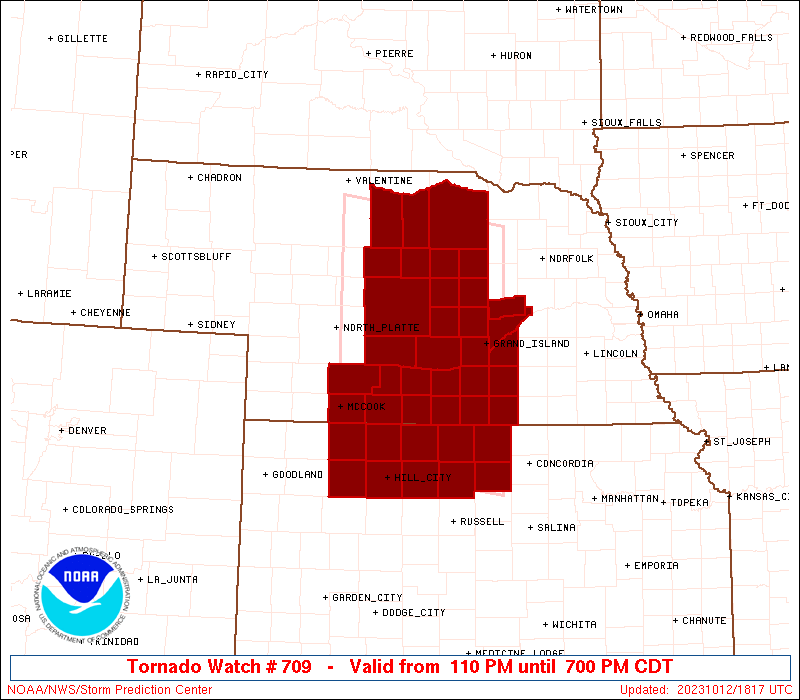
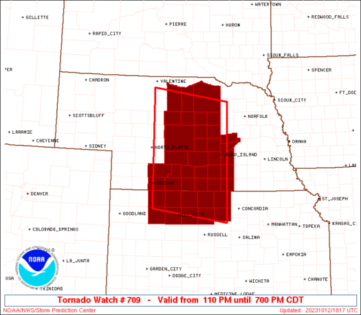
Tornado Watch Number 709
NWS Storm Prediction Center Norman OK
110 PM CDT Thu Oct 12 2023
The NWS Storm Prediction Center has issued a
* Tornado Watch for portions of
Northern Kansas
Central Nebraska
* Effective this Thursday afternoon and evening from 110 PM until
700 PM CDT.
* Primary threats include...
A few tornadoes possible
Scattered large hail likely with isolated very large hail events
to 2 inches in diameter possible
Isolated damaging wind gusts to 65 mph possible
SUMMARY...Scattered strong to severe thunderstorms are expected to
continue to develop across central Nebraska into northern Kansas
this afternoon, including some supercells capable of tornadoes and
large hail.
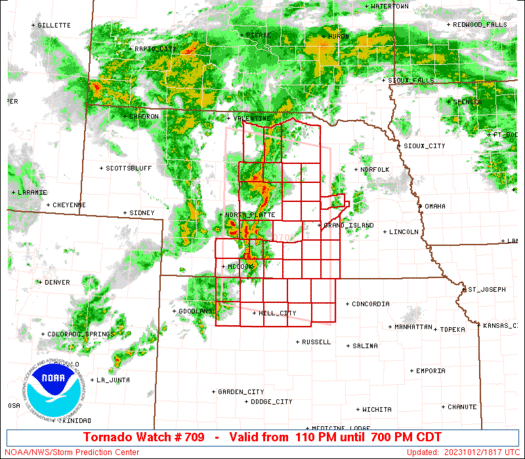
The tornado watch area is approximately along and 110 statute miles
north and south of a line from 55 miles west southwest of Broken Bow
NE to 20 miles southeast of Grand Island NE. For a complete
depiction of the watch see the associated watch outline update
(WOUS64 KWNS WOU9).
PRECAUTIONARY/PREPAREDNESS ACTIONS...
REMEMBER...A Tornado Watch means conditions are favorable for
tornadoes and severe thunderstorms in and close to the watch
area. Persons in these areas should be on the lookout for
threatening weather conditions and listen for later statements
and possible warnings.
&&
OTHER WATCH INFORMATION...CONTINUE...WW 708...
AVIATION...Tornadoes and a few severe thunderstorms with hail
surface and aloft to 2 inches. Extreme turbulence and surface wind
gusts to 55 knots. A few cumulonimbi with maximum tops to 450. Mean
storm motion vector 21030.
...Guyer
   SEL9

   URGENT - IMMEDIATE BROADCAST REQUESTED
   Tornado Watch Number 709
   NWS Storm Prediction Center Norman OK
   110 PM CDT Thu Oct 12 2023

   The NWS Storm Prediction Center has issued a

   * Tornado Watch for portions of
     Northern Kansas
     Central Nebraska

   * Effective this Thursday afternoon and evening from 110 PM until
     700 PM CDT.

   * Primary threats include...
     A few tornadoes possible
     Scattered large hail likely with isolated very large hail events
       to 2 inches in diameter possible
     Isolated damaging wind gusts to 65 mph possible

   SUMMARY...Scattered strong to severe thunderstorms are expected to
   continue to develop across central Nebraska into northern Kansas
   this afternoon, including some supercells capable of tornadoes and
   large hail.

   The tornado watch area is approximately along and 110 statute miles
   north and south of a line from 55 miles west southwest of Broken Bow
   NE to 20 miles southeast of Grand Island NE. For a complete
   depiction of the watch see the associated watch outline update
   (WOUS64 KWNS WOU9).

   PRECAUTIONARY/PREPAREDNESS ACTIONS...

   REMEMBER...A Tornado Watch means conditions are favorable for
   tornadoes and severe thunderstorms in and close to the watch
   area. Persons in these areas should be on the lookout for
   threatening weather conditions and listen for later statements
   and possible warnings.

   &&

   OTHER WATCH INFORMATION...CONTINUE...WW 708...

   AVIATION...Tornadoes and a few severe thunderstorms with hail
   surface and aloft to 2 inches. Extreme turbulence and surface wind
   gusts to 55 knots. A few cumulonimbi with maximum tops to 450. Mean
   storm motion vector 21030.

   ...Guyer
 Note:
The Aviation Watch (SAW) product is an approximation to the watch area.
The actual watch is depicted by the shaded areas.
Note:
The Aviation Watch (SAW) product is an approximation to the watch area.
The actual watch is depicted by the shaded areas.
   SAW9
   WW 709 TORNADO KS NE 121810Z - 130000Z
   AXIS..110 STATUTE MILES NORTH AND SOUTH OF LINE..
   55WSW BBW/BROKEN BOW NE/ - 20SE GRI/GRAND ISLAND NE/
   ..AVIATION COORDS.. 95NM N/S /5E LBF - 39SSE OBH/
   HAIL SURFACE AND ALOFT..2 INCHES. WIND GUSTS..55 KNOTS.
   MAX TOPS TO 450. MEAN STORM MOTION VECTOR 21030.

   LAT...LON 42710061 42369805 39169805 39530061

   THIS IS AN APPROXIMATION TO THE WATCH AREA.  FOR A
   COMPLETE DEPICTION OF THE WATCH SEE WOUS64 KWNS
   FOR WOU9.
Watch 709 Status Report Messages:
STATUS REPORT #5 ON WW 709
VALID 122230Z - 122340Z
SEVERE WEATHER THREAT CONTINUES RIGHT OF A LINE FROM 15 NW CNK TO
10 E HSI TO 20 W GRI TO 20 E BUB TO 20 WNW ONL.
FOR ADDITIONAL INFORMATION SEE MESOSCALE DISCUSSION 2249
..THORNTON..10/12/23
ATTN...WFO...GLD...GID...LBF...
&&
STATUS REPORT FOR WT 709
SEVERE WEATHER THREAT CONTINUES FOR THE FOLLOWING AREAS
NEC035-059-077-079-081-089-093-121-125-129-143-169-183-185-
122340-
NE
. NEBRASKA COUNTIES INCLUDED ARE
CLAY FILLMORE GREELEY
HALL HAMILTON HOLT
HOWARD MERRICK NANCE
NUCKOLLS POLK THAYER
WHEELER YORK
$$
THE WATCH STATUS MESSAGE IS FOR GUIDANCE PURPOSES ONLY. PLEASE
REFER TO WATCH COUNTY NOTIFICATION STATEMENTS FOR OFFICIAL
INFORMATION ON COUNTIES...INDEPENDENT CITIES AND MARINE ZONES
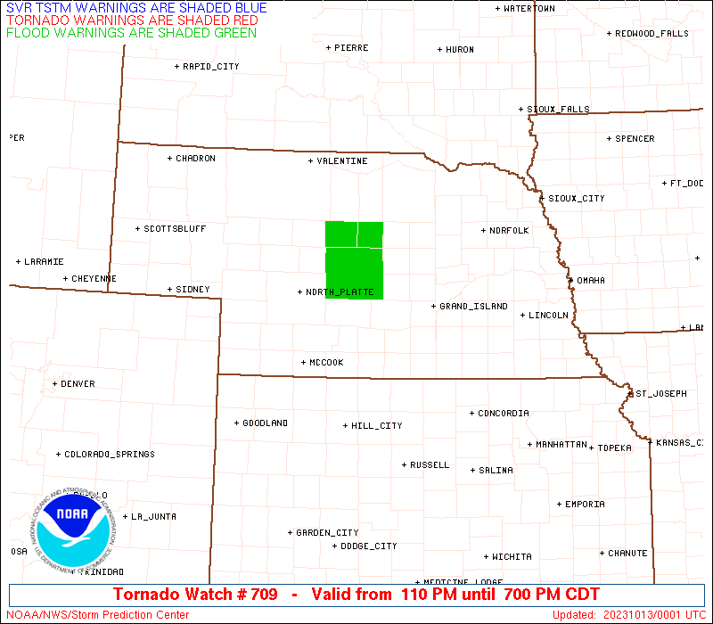
CLEARED FROM SEVERE THUNDERSTORM AND TORNADO WATCHES.
$$
STATUS REPORT #4 ON WW 709
VALID 122220Z - 122340Z
SEVERE WEATHER THREAT CONTINUES RIGHT OF A LINE FROM 15 NW CNK TO
10 E HSI TO 20 W GRI TO 20 E BUB TO 20 WNW ONL.
FOR ADDITIONAL INFORMATION SEE MESOSCALE DISCUSSION 2249
..THORNTON..10/12/23
ATTN...WFO...GLD...GID...LBF...
&&
STATUS REPORT FOR WT 709
SEVERE WEATHER THREAT CONTINUES FOR THE FOLLOWING AREAS
NEC035-059-077-079-081-089-093-121-125-129-143-169-183-185-
122340-
NE
. NEBRASKA COUNTIES INCLUDED ARE
CLAY FILLMORE GREELEY
HALL HAMILTON HOLT
HOWARD MERRICK NANCE
NUCKOLLS POLK THAYER
WHEELER YORK
$$
THE WATCH STATUS MESSAGE IS FOR GUIDANCE PURPOSES ONLY. PLEASE
REFER TO WATCH COUNTY NOTIFICATION STATEMENTS FOR OFFICIAL
INFORMATION ON COUNTIES...INDEPENDENT CITIES AND MARINE ZONES
CLEARED FROM SEVERE THUNDERSTORM AND TORNADO WATCHES.
$$
STATUS REPORT #3 ON WW 709
VALID 122220Z - 122340Z
SEVERE WEATHER THREAT CONTINUES RIGHT OF A LINE FROM 15 NW CNK TO
10 E HSI TO 20 W GRI TO 20 E BUB TO 20 WNW ONL.
FOR ADDITIONAL INFORMATION SEE MESOSCALE DISCUSSION 2249
..THORNTON..10/12/23
ATTN...WFO...GLD...GID...LBF...
&&
STATUS REPORT FOR WT 709
SEVERE WEATHER THREAT CONTINUES FOR THE FOLLOWING AREAS
NEC035-059-077-079-081-089-093-121-125-129-143-169-183-185-
122340-
NE
. NEBRASKA COUNTIES INCLUDED ARE
CLAY FILLMORE GREELEY
HALL HAMILTON HOLT
HOWARD MERRICK NANCE
NUCKOLLS POLK THAYER
WHEELER YORK
$$
THE WATCH STATUS MESSAGE IS FOR GUIDANCE PURPOSES ONLY. PLEASE
REFER TO WATCH COUNTY NOTIFICATION STATEMENTS FOR OFFICIAL
INFORMATION ON COUNTIES...INDEPENDENT CITIES AND MARINE ZONES
CLEARED FROM SEVERE THUNDERSTORM AND TORNADO WATCHES.
$$
STATUS REPORT #2 ON WW 709
VALID 122150Z - 122240Z
SEVERE WEATHER THREAT CONTINUES RIGHT OF A LINE FROM 30 NE RSL TO
10 N EAR TO 25 WNW ONL.
..THORNTON..10/12/23
ATTN...WFO...GLD...GID...LBF...
&&
STATUS REPORT FOR WT 709
SEVERE WEATHER THREAT CONTINUES FOR THE FOLLOWING AREAS
KSC089-123-122240-
KS
. KANSAS COUNTIES INCLUDED ARE
JEWELL MITCHELL
$$
NEC001-035-071-077-079-081-089-093-121-125-129-163-175-181-183-
122240-
NE
. NEBRASKA COUNTIES INCLUDED ARE
ADAMS CLAY GARFIELD
GREELEY HALL HAMILTON
HOLT HOWARD MERRICK
NANCE NUCKOLLS SHERMAN
VALLEY WEBSTER WHEELER
$$
THE WATCH STATUS MESSAGE IS FOR GUIDANCE PURPOSES ONLY. PLEASE
REFER TO WATCH COUNTY NOTIFICATION STATEMENTS FOR OFFICIAL
INFORMATION ON COUNTIES...INDEPENDENT CITIES AND MARINE ZONES
CLEARED FROM SEVERE THUNDERSTORM AND TORNADO WATCHES.
$$
STATUS REPORT #1 ON WW 709
VALID 122035Z - 122140Z
SEVERE WEATHER THREAT CONTINUES RIGHT OF A LINE FROM 30 SSW HLC
TO 15 ENE VTN.
..MOORE..10/12/23
ATTN...WFO...GLD...GID...LBF...
&&
STATUS REPORT FOR WT 709
SEVERE WEATHER THREAT CONTINUES FOR THE FOLLOWING AREAS
KSC065-089-123-137-141-147-163-183-122140-
KS
. KANSAS COUNTIES INCLUDED ARE
GRAHAM JEWELL MITCHELL
NORTON OSBORNE PHILLIPS
ROOKS SMITH
$$
NEC001-009-017-019-035-041-047-061-065-071-073-077-079-081-083-
089-093-099-115-121-125-129-137-149-163-175-181-183-122140-
NE
. NEBRASKA COUNTIES INCLUDED ARE
ADAMS BLAINE BROWN
BUFFALO CLAY CUSTER
DAWSON FRANKLIN FURNAS
GARFIELD GOSPER GREELEY
HALL HAMILTON HARLAN
HOLT HOWARD KEARNEY
LOUP MERRICK NANCE
NUCKOLLS PHELPS ROCK
SHERMAN VALLEY WEBSTER
WHEELER
$$
THE WATCH STATUS MESSAGE IS FOR GUIDANCE PURPOSES ONLY. PLEASE
REFER TO WATCH COUNTY NOTIFICATION STATEMENTS FOR OFFICIAL
INFORMATION ON COUNTIES...INDEPENDENT CITIES AND MARINE ZONES
CLEARED FROM SEVERE THUNDERSTORM AND TORNADO WATCHES.
$$
Note:
Click for Complete Product Text.
Tornadoes
Probability of 2 or more tornadoes
|
Mod (50%)
|
Probability of 1 or more strong (EF2-EF5) tornadoes
|
Low (10%)
|
Wind
Probability of 10 or more severe wind events
|
Mod (30%)
|
Probability of 1 or more wind events > 65 knots
|
Low (10%)
|
Hail
Probability of 10 or more severe hail events
|
Mod (60%)
|
Probability of 1 or more hailstones > 2 inches
|
Mod (30%)
|
Combined Severe Hail/Wind
Probability of 6 or more combined severe hail/wind events
|
High (90%)
|
For each watch, probabilities for particular events inside the watch
(listed above in each table) are determined by the issuing forecaster.
The "Low" category contains probability values ranging from less than 2%
to 20% (EF2-EF5 tornadoes), less than 5% to 20% (all other probabilities),
"Moderate" from 30% to 60%, and "High" from 70% to greater than 95%.
High values are bolded and lighter in color to provide awareness of
an increased threat for a particular event.


 @NWSSPC