Note:
The expiration time in the watch graphic is amended if the watch is
replaced, cancelled or extended.
Note:
Note:
The expiration time in the watch graphic is amended if the watch is
replaced, cancelled or extended.
Note: Click for
Watch Status Reports.
SEL1
URGENT - IMMEDIATE BROADCAST REQUESTED
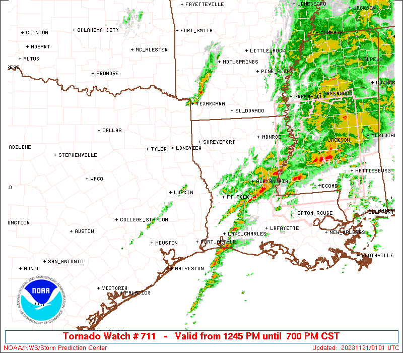
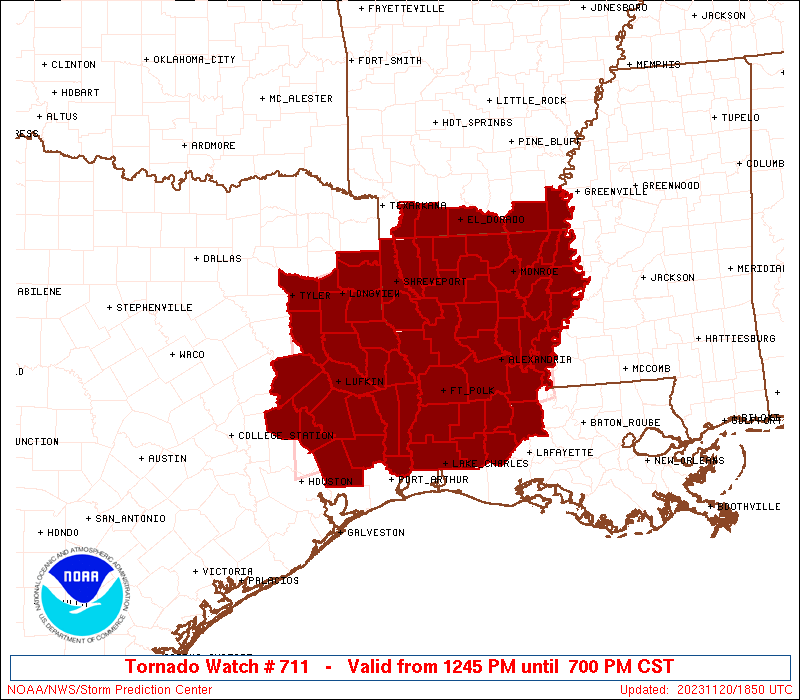
Tornado Watch Number 711
NWS Storm Prediction Center Norman OK
1245 PM CST Mon Nov 20 2023
The NWS Storm Prediction Center has issued a
* Tornado Watch for portions of
Southern Arkansas
Louisiana
East Texas
* Effective this Monday afternoon and evening from 1245 PM until
700 PM CST.
* Primary threats include...
A few tornadoes likely with a couple intense tornadoes possible
Scattered large hail and isolated very large hail events to 2
inches in diameter possible
Scattered damaging wind gusts to 70 mph possible
SUMMARY...Thunderstorms will continue to intensify this afternoon
and evening, while posing a threat for large hail, damaging winds,
and tornadoes. There is also a threat for strong tornadoes through
this evening with any supercells that can be sustained.
The tornado watch area is approximately along and 85 statute miles
north and south of a line from 40 miles west of Lufkin TX to 40
miles southeast of Monroe LA. For a complete depiction of the watch
see the associated watch outline update (WOUS64 KWNS WOU1).
PRECAUTIONARY/PREPAREDNESS ACTIONS...
REMEMBER...A Tornado Watch means conditions are favorable for
tornadoes and severe thunderstorms in and close to the watch
area. Persons in these areas should be on the lookout for
threatening weather conditions and listen for later statements
and possible warnings.
&&
AVIATION...Tornadoes and a few severe thunderstorms with hail
surface and aloft to 2 inches. Extreme turbulence and surface wind
gusts to 60 knots. A few cumulonimbi with maximum tops to 350. Mean
storm motion vector 25035.
...Gleason
   SEL1

   URGENT - IMMEDIATE BROADCAST REQUESTED
   Tornado Watch Number 711
   NWS Storm Prediction Center Norman OK
   1245 PM CST Mon Nov 20 2023

   The NWS Storm Prediction Center has issued a

   * Tornado Watch for portions of
     Southern Arkansas
     Louisiana
     East Texas

   * Effective this Monday afternoon and evening from 1245 PM until
     700 PM CST.

   * Primary threats include...
     A few tornadoes likely with a couple intense tornadoes possible
     Scattered large hail and isolated very large hail events to 2
       inches in diameter possible
     Scattered damaging wind gusts to 70 mph possible

   SUMMARY...Thunderstorms will continue to intensify this afternoon
   and evening, while posing a threat for large hail, damaging winds,
   and tornadoes. There is also a threat for strong tornadoes through
   this evening with any supercells that can be sustained.

   The tornado watch area is approximately along and 85 statute miles
   north and south of a line from 40 miles west of Lufkin TX to 40
   miles southeast of Monroe LA. For a complete depiction of the watch
   see the associated watch outline update (WOUS64 KWNS WOU1).

   PRECAUTIONARY/PREPAREDNESS ACTIONS...

   REMEMBER...A Tornado Watch means conditions are favorable for
   tornadoes and severe thunderstorms in and close to the watch
   area. Persons in these areas should be on the lookout for
   threatening weather conditions and listen for later statements
   and possible warnings.

   &&

   AVIATION...Tornadoes and a few severe thunderstorms with hail
   surface and aloft to 2 inches. Extreme turbulence and surface wind
   gusts to 60 knots. A few cumulonimbi with maximum tops to 350. Mean
   storm motion vector 25035.

   ...Gleason
 Note:
The Aviation Watch (SAW) product is an approximation to the watch area.
The actual watch is depicted by the shaded areas.
Note:
The Aviation Watch (SAW) product is an approximation to the watch area.
The actual watch is depicted by the shaded areas.
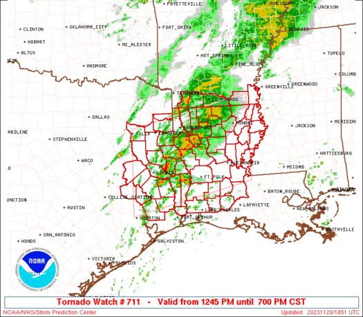
   SAW1
   WW 711 TORNADO AR LA TX 201845Z - 210100Z
   AXIS..85 STATUTE MILES NORTH AND SOUTH OF LINE..
   40W LFK/LUFKIN TX/ - 40SE MLU/MONROE LA/
   ..AVIATION COORDS.. 75NM N/S /37W LFK - 35SE MLU/
   HAIL SURFACE AND ALOFT..2 INCHES. WIND GUSTS..60 KNOTS.
   MAX TOPS TO 350. MEAN STORM MOTION VECTOR 25035.

   LAT...LON 32469543 33349155 30889155 30009543

   THIS IS AN APPROXIMATION TO THE WATCH AREA.  FOR A
   COMPLETE DEPICTION OF THE WATCH SEE WOUS64 KWNS
   FOR WOU1.
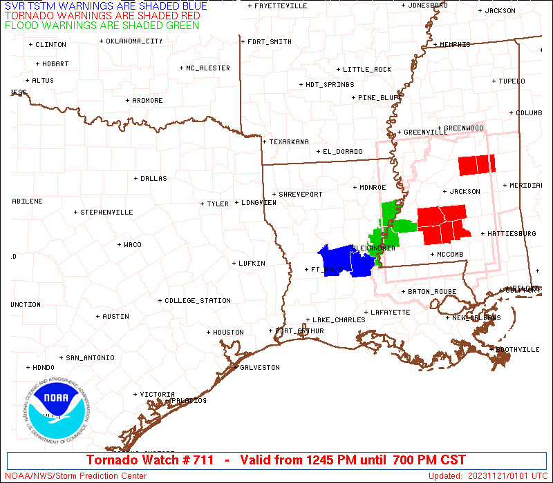
Watch 711 Status Report Messages:
STATUS REPORT #4 ON WW 711

VALID 202325Z - 210040Z

SEVERE WEATHER THREAT CONTINUES RIGHT OF A LINE FROM 25 NNE BPT
TO 15 N POE TO 25 NNW HEZ.

..SQUITIERI..11/20/23

ATTN...WFO...JAN...SHV...LCH...HGX...

&&

STATUS REPORT FOR WT 711

SEVERE WEATHER THREAT CONTINUES FOR THE FOLLOWING AREAS

LAC001-003-009-011-019-025-029-035-039-053-059-065-079-097-107-
210040-

LA
.    LOUISIANA PARISHES INCLUDED ARE

ACADIA		     ALLEN		 AVOYELLES
BEAUREGARD	     CALCASIEU		 CATAHOULA
CONCORDIA	     EAST CARROLL	 EVANGELINE
JEFFERSON DAVIS      LA SALLE		 MADISON
RAPIDES 	     ST. LANDRY 	 TENSAS
$$


THE WATCH STATUS MESSAGE IS FOR GUIDANCE PURPOSES ONLY.  PLEASE
REFER TO WATCH COUNTY NOTIFICATION STATEMENTS FOR OFFICIAL
INFORMATION ON COUNTIES...INDEPENDENT CITIES AND MARINE ZONES
CLEARED FROM SEVERE THUNDERSTORM AND TORNADO WATCHES.
$$

STATUS REPORT #3 ON WW 711

VALID 202215Z - 202340Z

SEVERE WEATHER THREAT CONTINUES RIGHT OF A LINE FROM 20 NW BPT TO
40 W POE TO 10 ENE IER TO 35 ESE MLU.

..SQUITIERI..11/20/23

ATTN...WFO...JAN...SHV...LCH...HGX...

&&

STATUS REPORT FOR WT 711

SEVERE WEATHER THREAT CONTINUES FOR THE FOLLOWING AREAS

LAC001-003-009-011-019-021-025-029-035-039-041-043-049-053-059-
065-067-069-073-079-083-097-107-115-123-127-202340-

LA
.    LOUISIANA PARISHES INCLUDED ARE

ACADIA		     ALLEN		 AVOYELLES
BEAUREGARD	     CALCASIEU		 CALDWELL
CATAHOULA	     CONCORDIA		 EAST CARROLL
EVANGELINE	     FRANKLIN		 GRANT
JACKSON 	     JEFFERSON DAVIS	 LA SALLE
MADISON 	     MOREHOUSE		 NATCHITOCHES
OUACHITA	     RAPIDES		 RICHLAND
ST. LANDRY	     TENSAS		 VERNON
WEST CARROLL	     WINN
$$


TXC351-361-202340-

TX
.    TEXAS COUNTIES INCLUDED ARE

NEWTON		     ORANGE
$$


THE WATCH STATUS MESSAGE IS FOR GUIDANCE PURPOSES ONLY.  PLEASE
REFER TO WATCH COUNTY NOTIFICATION STATEMENTS FOR OFFICIAL
INFORMATION ON COUNTIES...INDEPENDENT CITIES AND MARINE ZONES
CLEARED FROM SEVERE THUNDERSTORM AND TORNADO WATCHES.
$$

STATUS REPORT #2 ON WW 711

VALID 202130Z - 202240Z

SEVERE WEATHER THREAT CONTINUES RIGHT OF A LINE FROM 40 WNW BPT
TO 25 NNW IER TO 40 SW GLH.

..SQUITIERI..11/20/23

ATTN...WFO...JAN...SHV...LCH...HGX...

&&

STATUS REPORT FOR WT 711

SEVERE WEATHER THREAT CONTINUES FOR THE FOLLOWING AREAS

ARC017-202240-

AR
.    ARKANSAS COUNTIES INCLUDED ARE

CHICOT
$$


LAC001-003-009-011-019-021-025-029-035-039-041-043-049-053-059-
065-067-069-073-079-083-085-097-107-115-123-127-202240-

LA
.    LOUISIANA PARISHES INCLUDED ARE

ACADIA		     ALLEN		 AVOYELLES
BEAUREGARD	     CALCASIEU		 CALDWELL
CATAHOULA	     CONCORDIA		 EAST CARROLL
EVANGELINE	     FRANKLIN		 GRANT
JACKSON 	     JEFFERSON DAVIS	 LA SALLE
MADISON 	     MOREHOUSE		 NATCHITOCHES
OUACHITA	     RAPIDES		 RICHLAND
SABINE		     ST. LANDRY 	 TENSAS
VERNON		     WEST CARROLL	 WINN
$$


TXC199-241-351-361-403-202240-

TX
.    TEXAS COUNTIES INCLUDED ARE

HARDIN		     JASPER		 NEWTON
ORANGE		     SABINE
$$


THE WATCH STATUS MESSAGE IS FOR GUIDANCE PURPOSES ONLY.  PLEASE
REFER TO WATCH COUNTY NOTIFICATION STATEMENTS FOR OFFICIAL
INFORMATION ON COUNTIES...INDEPENDENT CITIES AND MARINE ZONES
CLEARED FROM SEVERE THUNDERSTORM AND TORNADO WATCHES.
$$

STATUS REPORT #1 ON WW 711

VALID 202125Z - 202240Z

SEVERE WEATHER THREAT CONTINUES RIGHT OF A LINE FROM 40 WNW BPT
TO 25 NNW IER TO 40 SW GLH.

..SQUITIERI..11/20/23

ATTN...WFO...JAN...SHV...LCH...HGX...

&&

STATUS REPORT FOR WT 711

SEVERE WEATHER THREAT CONTINUES FOR THE FOLLOWING AREAS

ARC017-202240-

AR
.    ARKANSAS COUNTIES INCLUDED ARE

CHICOT
$$


LAC001-003-009-011-019-021-025-029-035-039-041-043-049-053-059-
065-067-069-073-079-083-085-097-107-115-123-127-202240-

LA
.    LOUISIANA PARISHES INCLUDED ARE

ACADIA		     ALLEN		 AVOYELLES
BEAUREGARD	     CALCASIEU		 CALDWELL
CATAHOULA	     CONCORDIA		 EAST CARROLL
EVANGELINE	     FRANKLIN		 GRANT
JACKSON 	     JEFFERSON DAVIS	 LA SALLE
MADISON 	     MOREHOUSE		 NATCHITOCHES
OUACHITA	     RAPIDES		 RICHLAND
SABINE		     ST. LANDRY 	 TENSAS
VERNON		     WEST CARROLL	 WINN
$$


TXC199-241-351-361-403-202240-

TX
.    TEXAS COUNTIES INCLUDED ARE

HARDIN		     JASPER		 NEWTON
ORANGE		     SABINE
$$


THE WATCH STATUS MESSAGE IS FOR GUIDANCE PURPOSES ONLY.  PLEASE
REFER TO WATCH COUNTY NOTIFICATION STATEMENTS FOR OFFICIAL
INFORMATION ON COUNTIES...INDEPENDENT CITIES AND MARINE ZONES
CLEARED FROM SEVERE THUNDERSTORM AND TORNADO WATCHES.
$$
Note:
Click for Complete Product Text.
Tornadoes
Probability of 2 or more tornadoes
|
High (70%)
|
Probability of 1 or more strong (EF2-EF5) tornadoes
|
Mod (50%)
|
Wind
Probability of 10 or more severe wind events
|
Mod (50%)
|
Probability of 1 or more wind events > 65 knots
|
Low (20%)
|
Hail
Probability of 10 or more severe hail events
|
Mod (40%)
|
Probability of 1 or more hailstones > 2 inches
|
Mod (30%)
|
Combined Severe Hail/Wind
Probability of 6 or more combined severe hail/wind events
|
High (80%)
|
For each watch, probabilities for particular events inside the watch
(listed above in each table) are determined by the issuing forecaster.
The "Low" category contains probability values ranging from less than 2%
to 20% (EF2-EF5 tornadoes), less than 5% to 20% (all other probabilities),
"Moderate" from 30% to 60%, and "High" from 70% to greater than 95%.
High values are bolded and lighter in color to provide awareness of
an increased threat for a particular event.


 @NWSSPC