|
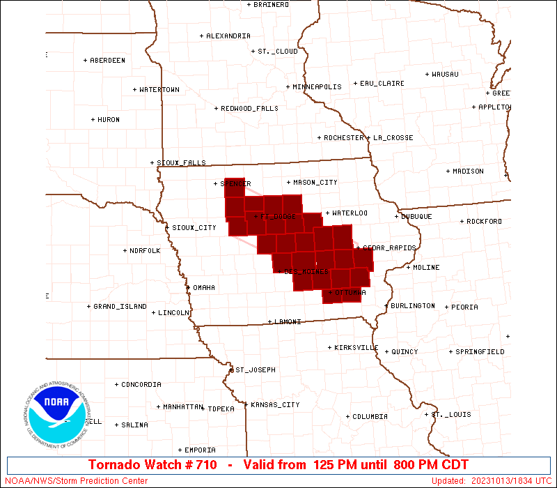
Initial List of Counties in SPC Tornado Watch 710 (WOU)
|
Back to Watch 710
|
 |
   WOUS64 KWNS 131827
   WOU0

   BULLETIN - IMMEDIATE BROADCAST REQUESTED
   TORNADO WATCH OUTLINE UPDATE FOR WT 710
   NWS STORM PREDICTION CENTER NORMAN OK
   125 PM CDT FRI OCT 13 2023

   TORNADO WATCH 710 IS IN EFFECT UNTIL 800 PM CDT FOR THE
    FOLLOWING LOCATIONS

   IAC011-015-025-069-075-079-083-091-095-099-101-103-107-123-125-
   127-147-151-153-157-169-171-179-183-187-197-140100-
   /O.NEW.KWNS.TO.A.0710.231013T1825Z-231014T0100Z/

   IA
   .    IOWA COUNTIES INCLUDED ARE

   BENTON               BOONE               CALHOUN
   FRANKLIN             GRUNDY              HAMILTON
   HARDIN               HUMBOLDT            IOWA
   JASPER               JEFFERSON           JOHNSON
   KEOKUK               MAHASKA             MARION
   MARSHALL             PALO ALTO           POCAHONTAS
   POLK                 POWESHIEK           STORY
   TAMA                 WAPELLO             WASHINGTON
   WEBSTER              WRIGHT


   ATTN...WFO...DVN...DMX...
|
| Aviation Watch (SAW) for WW710 |
|---|
 |
| Note:
The Aviation Watch (SAW) product is an approximation to the watch area.
The actual watch is depicted by the shaded areas. |
   SAW0
   WW 710 TORNADO IA 131825Z - 140100Z
   AXIS..35 STATUTE MILES NORTH AND SOUTH OF LINE..
   35WNW FOD/FORT DODGE IA/ - 30S CID/CEDAR RAPIDS IA/
   ..AVIATION COORDS.. 30NM N/S /25WNW FOD - 7SW IOW/
   HAIL SURFACE AND ALOFT..1 INCH. WIND GUSTS..50 KNOTS.
   MAX TOPS TO 350. MEAN STORM MOTION VECTOR 18020.

   LAT...LON 43259484 41959172 40939172 42249484

   THIS IS AN APPROXIMATION TO THE WATCH AREA.  FOR A
   COMPLETE DEPICTION OF THE WATCH SEE WOUS64 KWNS
   FOR WOU0.
|
|


 @NWSSPC