 Note:
The expiration time in the watch graphic is amended if the watch is
replaced, cancelled or extended.
Note:
Note:
The expiration time in the watch graphic is amended if the watch is
replaced, cancelled or extended.
Note: Click for
Watch Status Reports.
SEL7
URGENT - IMMEDIATE BROADCAST REQUESTED
Tornado Watch Number 97
NWS Storm Prediction Center Norman OK
555 PM CDT Fri Mar 31 2023
The NWS Storm Prediction Center has issued a
* Tornado Watch for portions of
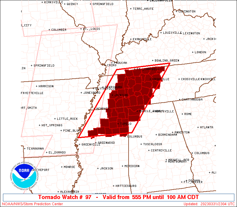
Northwestern Alabama
Northern Mississippi
Western and Middle Tennessee
* Effective this Friday afternoon and Saturday morning from 555
PM until 100 AM CDT.
...THIS IS A PARTICULARLY DANGEROUS SITUATION...
* Primary threats include...
Several tornadoes and a few intense tornadoes likely
Scattered damaging winds and isolated significant gusts to 80
mph likely
Scattered large hail and isolated very large hail events to 2.5
inches in diameter possible
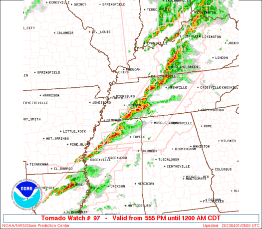
SUMMARY...The threat for both discrete, tornadic supercells and an
eventual severe squall line will spread across the watch area
through the evening. A favorably unstable, strong-shear environment
will support the threat for significant (EF2+) tornadoes. Severe
thunderstorm gusts and large, locally damaging hail also are
expected.
The tornado watch area is approximately along and 85 statute miles
east and west of a line from 40 miles south of Oxford MS to 25 miles
east northeast of Clarksville TN. For a complete depiction of the
watch see the associated watch outline update (WOUS64 KWNS WOU7).
PRECAUTIONARY/PREPAREDNESS ACTIONS...
REMEMBER...A Tornado Watch means conditions are favorable for
tornadoes and severe thunderstorms in and close to the watch
area. Persons in these areas should be on the lookout for
threatening weather conditions and listen for later statements
and possible warnings.
&&
OTHER WATCH INFORMATION...CONTINUE...WW 93...WW 94...WW 95...WW
96...
AVIATION...Tornadoes and a few severe thunderstorms with hail
surface and aloft to 2.5 inches. Extreme turbulence and surface wind
gusts to 70 knots. A few cumulonimbi with maximum tops to 550. Mean
storm motion vector 25045.
...Edwards
   SEL7

   URGENT - IMMEDIATE BROADCAST REQUESTED
   Tornado Watch Number 97
   NWS Storm Prediction Center Norman OK
   555 PM CDT Fri Mar 31 2023

   The NWS Storm Prediction Center has issued a

   * Tornado Watch for portions of
     Northwestern Alabama
     Northern Mississippi
     Western and Middle Tennessee

   * Effective this Friday afternoon and Saturday morning from 555
     PM until 100 AM CDT.

   ...THIS IS A PARTICULARLY DANGEROUS SITUATION...

   * Primary threats include...
     Several tornadoes and a few intense tornadoes likely
     Scattered damaging winds and isolated significant gusts to 80
       mph likely
     Scattered large hail and isolated very large hail events to 2.5
       inches in diameter possible

   SUMMARY...The threat for both discrete, tornadic supercells and an
   eventual severe squall line will spread across the watch area
   through the evening.  A favorably unstable, strong-shear environment
   will support the threat for significant (EF2+) tornadoes.  Severe
   thunderstorm gusts and large, locally damaging hail also are
   expected.

   The tornado watch area is approximately along and 85 statute miles
   east and west of a line from 40 miles south of Oxford MS to 25 miles
   east northeast of Clarksville TN. For a complete depiction of the
   watch see the associated watch outline update (WOUS64 KWNS WOU7).

   PRECAUTIONARY/PREPAREDNESS ACTIONS...

   REMEMBER...A Tornado Watch means conditions are favorable for
   tornadoes and severe thunderstorms in and close to the watch
   area. Persons in these areas should be on the lookout for
   threatening weather conditions and listen for later statements
   and possible warnings.

   &&

   OTHER WATCH INFORMATION...CONTINUE...WW 93...WW 94...WW 95...WW
   96...

   AVIATION...Tornadoes and a few severe thunderstorms with hail
   surface and aloft to 2.5 inches. Extreme turbulence and surface wind
   gusts to 70 knots. A few cumulonimbi with maximum tops to 550. Mean
   storm motion vector 25045.

   ...Edwards
 Note:
The Aviation Watch (SAW) product is an approximation to the watch area.
The actual watch is depicted by the shaded areas.
Note:
The Aviation Watch (SAW) product is an approximation to the watch area.
The actual watch is depicted by the shaded areas.
   SAW7
   WW 97 TORNADO AL MS TN 312255Z - 010600Z
   AXIS..85 STATUTE MILES EAST AND WEST OF LINE..
   40S UOX/OXFORD MS/ - 25ENE CKV/CLARKSVILLE TN/
   ..AVIATION COORDS.. 75NM E/W /43ENE SQS - 29WSW BWG/
   HAIL SURFACE AND ALOFT..2.5 INCHES. WIND GUSTS..70 KNOTS.
   MAX TOPS TO 550. MEAN STORM MOTION VECTOR 25045.

   LAT...LON 33799101 36748854 36748547 33798805

   THIS IS AN APPROXIMATION TO THE WATCH AREA.  FOR A
   COMPLETE DEPICTION OF THE WATCH SEE WOUS64 KWNS
   FOR WOU7.
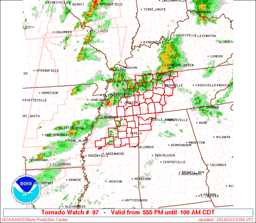
Watch 97 Status Report Messages:
STATUS REPORT #4 ON WW 97

VALID 010430Z - 010540Z

SEVERE WEATHER THREAT CONTINUES RIGHT OF A LINE FROM 45 N GLH TO
30 NE MKL TO 20 NNE HOP.

..BROYLES..04/01/23

ATTN...WFO...HUN...MEG...OHX...

&&

STATUS REPORT FOR WT 97

SEVERE WEATHER THREAT CONTINUES FOR THE FOLLOWING AREAS

ALC033-059-077-010540-

AL
.    ALABAMA COUNTIES INCLUDED ARE

COLBERT 	     FRANKLIN		 LAUDERDALE
$$


MSC003-009-013-017-027-033-057-071-081-093-095-107-115-117-119-
135-137-139-141-145-161-010540-

MS
.    MISSISSIPPI COUNTIES INCLUDED ARE

ALCORN		     BENTON		 CALHOUN
CHICKASAW	     COAHOMA		 DESOTO
ITAWAMBA	     LAFAYETTE		 LEE
MARSHALL	     MONROE		 PANOLA
PONTOTOC	     PRENTISS		 QUITMAN
TALLAHATCHIE	     TATE		 TIPPAH
TISHOMINGO	     UNION		 YALOBUSHA
$$


TNC005-021-023-037-039-043-047-055-069-071-077-081-083-085-099-
101-109-111-113-117-119-125-135-147-149-165-169-181-187-189-
010540-

TN
.    TENNESSEE COUNTIES INCLUDED ARE

BENTON		     CHEATHAM		 CHESTER
DAVIDSON	     DECATUR		 DICKSON
FAYETTE 	     GILES		 HARDEMAN
HARDIN		     HENDERSON		 HICKMAN
HOUSTON 	     HUMPHREYS		 LAWRENCE
LEWIS		     MCNAIRY		 MACON
MADISON 	     MARSHALL		 MAURY
MONTGOMERY	     PERRY		 ROBERTSON
RUTHERFORD	     SUMNER		 TROUSDALE
WAYNE		     WILLIAMSON 	 WILSON
$$


THE WATCH STATUS MESSAGE IS FOR GUIDANCE PURPOSES ONLY.  PLEASE
REFER TO WATCH COUNTY NOTIFICATION STATEMENTS FOR OFFICIAL
INFORMATION ON COUNTIES...INDEPENDENT CITIES AND MARINE ZONES
CLEARED FROM SEVERE THUNDERSTORM AND TORNADO WATCHES.
$$

STATUS REPORT #3 ON WW 97

VALID 010255Z - 010340Z

THE SEVERE WEATHER THREAT CONTINUES ACROSS THE ENTIRE WATCH AREA.

FOR ADDITIONAL INFORMATION SEE MESOSCALE DISCUSSION 420

..THORNTON..04/01/23

ATTN...WFO...HUN...MEG...OHX...

&&

STATUS REPORT FOR WT 97

SEVERE WEATHER THREAT CONTINUES FOR THE FOLLOWING AREAS

ALC033-059-077-010340-

AL
.    ALABAMA COUNTIES INCLUDED ARE

COLBERT 	     FRANKLIN		 LAUDERDALE
$$


MSC003-009-013-017-027-033-057-071-081-093-095-107-115-117-119-
135-137-139-141-143-145-161-010340-

MS
.    MISSISSIPPI COUNTIES INCLUDED ARE

ALCORN		     BENTON		 CALHOUN
CHICKASAW	     COAHOMA		 DESOTO
ITAWAMBA	     LAFAYETTE		 LEE
MARSHALL	     MONROE		 PANOLA
PONTOTOC	     PRENTISS		 QUITMAN
TALLAHATCHIE	     TATE		 TIPPAH
TISHOMINGO	     TUNICA		 UNION
YALOBUSHA
$$


TNC005-017-021-023-033-037-039-043-047-053-055-069-071-075-077-
079-081-083-085-097-099-101-109-111-113-117-119-125-135-147-149-
157-161-165-167-169-181-183-187-189-010340-

TN
.    TENNESSEE COUNTIES INCLUDED ARE

BENTON		     CARROLL		 CHEATHAM
CHESTER 	     CROCKETT		 DAVIDSON
DECATUR 	     DICKSON		 FAYETTE
GIBSON		     GILES		 HARDEMAN
HARDIN		     HAYWOOD		 HENDERSON
HENRY		     HICKMAN		 HOUSTON
HUMPHREYS	     LAUDERDALE 	 LAWRENCE
LEWIS		     MCNAIRY		 MACON
MADISON 	     MARSHALL		 MAURY
MONTGOMERY	     PERRY		 ROBERTSON
RUTHERFORD	     SHELBY		 STEWART
SUMNER		     TIPTON		 TROUSDALE
WAYNE		     WEAKLEY		 WILLIAMSON
WILSON
$$


THE WATCH STATUS MESSAGE IS FOR GUIDANCE PURPOSES ONLY.  PLEASE
REFER TO WATCH COUNTY NOTIFICATION STATEMENTS FOR OFFICIAL
INFORMATION ON COUNTIES...INDEPENDENT CITIES AND MARINE ZONES
CLEARED FROM SEVERE THUNDERSTORM AND TORNADO WATCHES.
$$

STATUS REPORT #2 ON WW 97

VALID 010105Z - 010240Z

THE SEVERE WEATHER THREAT CONTINUES ACROSS THE ENTIRE WATCH AREA.

..THORNTON..04/01/23

ATTN...WFO...HUN...MEG...OHX...

&&

STATUS REPORT FOR WT 97

SEVERE WEATHER THREAT CONTINUES FOR THE FOLLOWING AREAS

ALC033-059-077-010240-

AL
.    ALABAMA COUNTIES INCLUDED ARE

COLBERT 	     FRANKLIN		 LAUDERDALE
$$


MSC003-009-013-017-057-071-081-095-115-117-135-139-141-145-161-
010240-

MS
.    MISSISSIPPI COUNTIES INCLUDED ARE

ALCORN		     BENTON		 CALHOUN
CHICKASAW	     ITAWAMBA		 LAFAYETTE
LEE		     MONROE		 PONTOTOC
PRENTISS	     TALLAHATCHIE	 TIPPAH
TISHOMINGO	     UNION		 YALOBUSHA
$$


TNC005-017-021-023-037-039-043-055-069-071-077-079-081-083-085-
099-101-109-111-113-117-119-125-135-147-149-161-165-169-181-187-
189-010240-

TN
.    TENNESSEE COUNTIES INCLUDED ARE

BENTON		     CARROLL		 CHEATHAM
CHESTER 	     DAVIDSON		 DECATUR
DICKSON 	     GILES		 HARDEMAN
HARDIN		     HENDERSON		 HENRY
HICKMAN 	     HOUSTON		 HUMPHREYS
LAWRENCE	     LEWIS		 MCNAIRY
MACON		     MADISON		 MARSHALL
MAURY		     MONTGOMERY 	 PERRY
ROBERTSON	     RUTHERFORD 	 STEWART
SUMNER		     TROUSDALE		 WAYNE
WILLIAMSON	     WILSON
$$


THE WATCH STATUS MESSAGE IS FOR GUIDANCE PURPOSES ONLY.  PLEASE
REFER TO WATCH COUNTY NOTIFICATION STATEMENTS FOR OFFICIAL
INFORMATION ON COUNTIES...INDEPENDENT CITIES AND MARINE ZONES
CLEARED FROM SEVERE THUNDERSTORM AND TORNADO WATCHES.
$$

STATUS REPORT #1 ON WW 97

VALID 010000Z - 010140Z

THE SEVERE WEATHER THREAT CONTINUES ACROSS THE ENTIRE WATCH AREA.

FOR ADDITIONAL INFORMATION SEE MESOSCALE DISCUSSION 411

..THORNTON..03/31/23

ATTN...WFO...HUN...MEG...OHX...

&&

STATUS REPORT FOR WT 97

SEVERE WEATHER THREAT CONTINUES FOR THE FOLLOWING AREAS

ALC033-059-077-010140-

AL
.    ALABAMA COUNTIES INCLUDED ARE

COLBERT 	     FRANKLIN		 LAUDERDALE
$$


MSC003-009-013-017-057-071-081-095-115-117-135-139-141-145-161-
010140-

MS
.    MISSISSIPPI COUNTIES INCLUDED ARE

ALCORN		     BENTON		 CALHOUN
CHICKASAW	     ITAWAMBA		 LAFAYETTE
LEE		     MONROE		 PONTOTOC
PRENTISS	     TALLAHATCHIE	 TIPPAH
TISHOMINGO	     UNION		 YALOBUSHA
$$


TNC005-017-021-023-037-039-043-055-069-071-077-079-081-083-085-
099-101-109-111-113-117-119-125-135-147-149-161-165-169-181-187-
189-010140-

TN
.    TENNESSEE COUNTIES INCLUDED ARE

BENTON		     CARROLL		 CHEATHAM
CHESTER 	     DAVIDSON		 DECATUR
DICKSON 	     GILES		 HARDEMAN
HARDIN		     HENDERSON		 HENRY
HICKMAN 	     HOUSTON		 HUMPHREYS
LAWRENCE	     LEWIS		 MCNAIRY
MACON		     MADISON		 MARSHALL
MAURY		     MONTGOMERY 	 PERRY
ROBERTSON	     RUTHERFORD 	 STEWART
SUMNER		     TROUSDALE		 WAYNE
WILLIAMSON	     WILSON
$$


THE WATCH STATUS MESSAGE IS FOR GUIDANCE PURPOSES ONLY.  PLEASE
REFER TO WATCH COUNTY NOTIFICATION STATEMENTS FOR OFFICIAL
INFORMATION ON COUNTIES...INDEPENDENT CITIES AND MARINE ZONES
CLEARED FROM SEVERE THUNDERSTORM AND TORNADO WATCHES.
$$
Note:
Click for Complete Product Text.
Tornadoes
Probability of 2 or more tornadoes
|
High (90%)
|
Probability of 1 or more strong (EF2-EF5) tornadoes
|
High (80%)
|
Wind
Probability of 10 or more severe wind events
|
High (70%)
|
Probability of 1 or more wind events > 65 knots
|
Mod (60%)
|
Hail
Probability of 10 or more severe hail events
|
Mod (40%)
|
Probability of 1 or more hailstones > 2 inches
|
Mod (30%)
|
Combined Severe Hail/Wind
Probability of 6 or more combined severe hail/wind events
|
High (>95%)
|
For each watch, probabilities for particular events inside the watch
(listed above in each table) are determined by the issuing forecaster.
The "Low" category contains probability values ranging from less than 2%
to 20% (EF2-EF5 tornadoes), less than 5% to 20% (all other probabilities),
"Moderate" from 30% to 60%, and "High" from 70% to greater than 95%.
High values are bolded and lighter in color to provide awareness of
an increased threat for a particular event.


 @NWSSPC