Note:
The expiration time in the watch graphic is amended if the watch is
replaced, cancelled or extended.
Note:
Note:
The expiration time in the watch graphic is amended if the watch is
replaced, cancelled or extended.
Note: Click for
Watch Status Reports.
SEL4
URGENT - IMMEDIATE BROADCAST REQUESTED
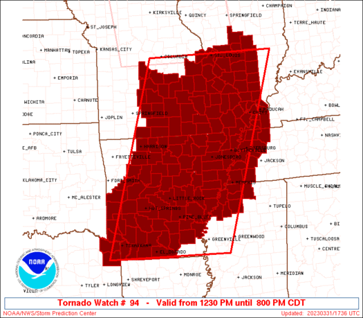
Tornado Watch Number 94
NWS Storm Prediction Center Norman OK
1230 PM CDT Fri Mar 31 2023
The NWS Storm Prediction Center has issued a
* Tornado Watch for portions of
Much of Arkansas
Southern Illinois
Western Kentucky
Southern Missouri
Northwest Mississippi
West Tennessee
Northeast Texas
* Effective this Friday afternoon and evening from 1230 PM until
800 PM CDT.
...THIS IS A PARTICULARLY DANGEROUS SITUATION...
* Primary threats include...
Several tornadoes and a few intense tornadoes likely
Scattered large hail and isolated very large hail events to 2.5
inches in diameter likely
Scattered damaging wind gusts to 70 mph likely
SUMMARY...Numerous severe thunderstorms are expected to develop and
spread across the mid Mississippi Valley region this afternoon and
early evening. Supercells capable of damaging tornadoes, large
hail, and damaging winds are all possible. Parameters are
sufficiently favorable for the risk of strong/violent tornadoes.
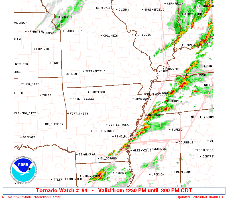
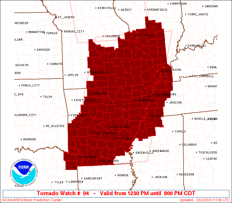
The tornado watch area is approximately along and 120 statute miles
east and west of a line from 30 miles east southeast of El Dorado AR
to 5 miles northwest of Saint Louis MO. For a complete depiction of
the watch see the associated watch outline update (WOUS64 KWNS
WOU4).
PRECAUTIONARY/PREPAREDNESS ACTIONS...
REMEMBER...A Tornado Watch means conditions are favorable for
tornadoes and severe thunderstorms in and close to the watch
area. Persons in these areas should be on the lookout for
threatening weather conditions and listen for later statements
and possible warnings.
&&
OTHER WATCH INFORMATION...CONTINUE...WW 93...
AVIATION...Tornadoes and a few severe thunderstorms with hail
surface and aloft to 2.5 inches. Extreme turbulence and surface wind
gusts to 60 knots. A few cumulonimbi with maximum tops to 500. Mean
storm motion vector 25035.
...Hart
   SEL4

   URGENT - IMMEDIATE BROADCAST REQUESTED
   Tornado Watch Number 94
   NWS Storm Prediction Center Norman OK
   1230 PM CDT Fri Mar 31 2023

   The NWS Storm Prediction Center has issued a

   * Tornado Watch for portions of
     Much of Arkansas
     Southern Illinois
     Western Kentucky
     Southern Missouri
     Northwest Mississippi
     West Tennessee
     Northeast Texas

   * Effective this Friday afternoon and evening from 1230 PM until
     800 PM CDT.

   ...THIS IS A PARTICULARLY DANGEROUS SITUATION...

   * Primary threats include...
     Several tornadoes and a few intense tornadoes likely
     Scattered large hail and isolated very large hail events to 2.5
       inches in diameter likely
     Scattered damaging wind gusts to 70 mph likely

   SUMMARY...Numerous severe thunderstorms are expected to develop and
   spread across the mid Mississippi Valley region this afternoon and
   early evening.  Supercells capable of damaging tornadoes, large
   hail, and damaging winds are all possible.  Parameters are
   sufficiently favorable for the risk of strong/violent tornadoes.

   The tornado watch area is approximately along and 120 statute miles
   east and west of a line from 30 miles east southeast of El Dorado AR
   to 5 miles northwest of Saint Louis MO. For a complete depiction of
   the watch see the associated watch outline update (WOUS64 KWNS
   WOU4).

   PRECAUTIONARY/PREPAREDNESS ACTIONS...

   REMEMBER...A Tornado Watch means conditions are favorable for
   tornadoes and severe thunderstorms in and close to the watch
   area. Persons in these areas should be on the lookout for
   threatening weather conditions and listen for later statements
   and possible warnings.

   &&

   OTHER WATCH INFORMATION...CONTINUE...WW 93...

   AVIATION...Tornadoes and a few severe thunderstorms with hail
   surface and aloft to 2.5 inches. Extreme turbulence and surface wind
   gusts to 60 knots. A few cumulonimbi with maximum tops to 500. Mean
   storm motion vector 25035.

   ...Hart
 Note:
The Aviation Watch (SAW) product is an approximation to the watch area.
The actual watch is depicted by the shaded areas.
Note:
The Aviation Watch (SAW) product is an approximation to the watch area.
The actual watch is depicted by the shaded areas.
   SAW4
   WW 94 TORNADO AR IL KY MO MS TN TX 311730Z - 010100Z
   AXIS..120 STATUTE MILES EAST AND WEST OF LINE..
   30ESE ELD/EL DORADO AR/ - 5NW STL/SAINT LOUIS MO/
   ..AVIATION COORDS.. 105NM E/W /24ESE ELD - 4SSE STL/
   HAIL SURFACE AND ALOFT..2.5 INCHES. WIND GUSTS..60 KNOTS.
   MAX TOPS TO 500. MEAN STORM MOTION VECTOR 25035.

   LAT...LON 33049441 38789266 38788821 33049027

   THIS IS AN APPROXIMATION TO THE WATCH AREA.  FOR A
   COMPLETE DEPICTION OF THE WATCH SEE WOUS64 KWNS
   FOR WOU4.
Watch 94 Status Report Messages:
STATUS REPORT #7 ON WW 94

VALID 010100Z - 010240Z

SEVERE WEATHER THREAT CONTINUES RIGHT OF A LINE FROM 40 NW SHV TO
30 E TXK TO 15 S LIT TO 35 SSE BVX TO 20 SW JBR TO 25 ENE ARG TO
25 SE FAM TO 20 NNW FAM TO 25 NNW FAM TO 25 NNW STL.

FOR ADDITIONAL INFORMATION SEE MESOSCALE DISCUSSION 415

..THORNTON..04/01/23

ATTN...WFO...LZK...MEG...SHV...PAH...LSX...SGF...

&&

STATUS REPORT FOR WT 94

SEVERE WEATHER THREAT CONTINUES FOR THE FOLLOWING AREAS

ARC001-011-013-021-025-027-031-035-037-039-041-043-053-069-073-
077-079-085-093-095-103-107-111-117-123-139-147-010240-

AR
.    ARKANSAS COUNTIES INCLUDED ARE

ARKANSAS	     BRADLEY		 CALHOUN
CLAY		     CLEVELAND		 COLUMBIA
CRAIGHEAD	     CRITTENDEN 	 CROSS
DALLAS		     DESHA		 DREW
GRANT		     JEFFERSON		 LAFAYETTE
LEE		     LINCOLN		 LONOKE
MISSISSIPPI	     MONROE		 OUACHITA
PHILLIPS	     POINSETT		 PRAIRIE
ST. FRANCIS	     UNION		 WOODRUFF
$$


ILC003-005-027-051-055-077-081-087-119-121-127-133-135-145-153-
157-163-181-189-199-010240-

IL
.    ILLINOIS COUNTIES INCLUDED ARE

ALEXANDER	     BOND		 CLINTON
FAYETTE 	     FRANKLIN		 JACKSON
JEFFERSON	     JOHNSON		 MADISON
MARION		     MASSAC		 MONROE
MONTGOMERY	     PERRY		 PULASKI
RANDOLPH	     ST. CLAIR		 UNION
WASHINGTON	     WILLIAMSON
$$


KYC007-039-075-083-105-145-010240-

KY
.    KENTUCKY COUNTIES INCLUDED ARE

BALLARD 	     CARLISLE		 FULTON
GRAVES		     HICKMAN		 MCCRACKEN
$$


MSC027-033-093-107-119-137-143-010240-

MS
.    MISSISSIPPI COUNTIES INCLUDED ARE

COAHOMA 	     DESOTO		 MARSHALL
PANOLA		     QUITMAN		 TATE
TUNICA
$$


MOC017-031-069-099-133-143-155-157-186-189-201-207-510-010240-

MO
.    MISSOURI COUNTIES INCLUDED ARE

BOLLINGER	     CAPE GIRARDEAU	 DUNKLIN
JEFFERSON	     MISSISSIPPI	 NEW MADRID
PEMISCOT	     PERRY		 STE. GENEVIEVE
ST. LOUIS	     SCOTT		 STODDARD


MISSOURI INDEPENDENT CITIES INCLUDED ARE

ST. LOUIS CITY
$$


TNC033-045-047-053-075-095-097-131-157-167-183-010240-

TN
.    TENNESSEE COUNTIES INCLUDED ARE

CROCKETT	     DYER		 FAYETTE
GIBSON		     HAYWOOD		 LAKE
LAUDERDALE	     OBION		 SHELBY
TIPTON		     WEAKLEY
$$


THE WATCH STATUS MESSAGE IS FOR GUIDANCE PURPOSES ONLY.  PLEASE
REFER TO WATCH COUNTY NOTIFICATION STATEMENTS FOR OFFICIAL
INFORMATION ON COUNTIES...INDEPENDENT CITIES AND MARINE ZONES
CLEARED FROM SEVERE THUNDERSTORM AND TORNADO WATCHES.
$$

STATUS REPORT #6 ON WW 94

VALID 312345Z - 010040Z

SEVERE WEATHER THREAT CONTINUES RIGHT OF A LINE FROM 45 WSW TXK
TO 10 NNE TXK TO 25 NE HOT TO 35 NNE LIT TO 15 E BVX TO 40 E UNO
TO 25 NW POF TO 25 NNW STL.

FOR ADDITIONAL INFORMATION SEE MESOSCALE DISCUSSION 414

..THORNTON..03/31/23

ATTN...WFO...LZK...MEG...SHV...PAH...LSX...SGF...

&&

STATUS REPORT FOR WT 94

SEVERE WEATHER THREAT CONTINUES FOR THE FOLLOWING AREAS

ARC001-011-013-019-021-025-027-031-035-037-039-041-043-053-055-
057-059-063-067-069-073-075-077-079-085-091-093-095-099-103-107-
111-117-119-121-123-125-135-139-145-147-010040-

AR
.    ARKANSAS COUNTIES INCLUDED ARE

ARKANSAS	     BRADLEY		 CALHOUN
CLARK		     CLAY		 CLEVELAND
COLUMBIA	     CRAIGHEAD		 CRITTENDEN
CROSS		     DALLAS		 DESHA
DREW		     GRANT		 GREENE
HEMPSTEAD	     HOT SPRING 	 INDEPENDENCE
JACKSON 	     JEFFERSON		 LAFAYETTE
LAWRENCE	     LEE		 LINCOLN
LONOKE		     MILLER		 MISSISSIPPI
MONROE		     NEVADA		 OUACHITA
PHILLIPS	     POINSETT		 PRAIRIE
PULASKI 	     RANDOLPH		 ST. FRANCIS
SALINE		     SHARP		 UNION
WHITE		     WOODRUFF
$$


ILC003-005-027-051-055-077-081-087-119-121-127-133-135-145-153-
157-163-181-189-199-010040-

IL
.    ILLINOIS COUNTIES INCLUDED ARE

ALEXANDER	     BOND		 CLINTON
FAYETTE 	     FRANKLIN		 JACKSON
JEFFERSON	     JOHNSON		 MADISON
MARION		     MASSAC		 MONROE
MONTGOMERY	     PERRY		 PULASKI
RANDOLPH	     ST. CLAIR		 UNION
WASHINGTON	     WILLIAMSON
$$


KYC007-039-075-083-105-145-010040-

KY
.    KENTUCKY COUNTIES INCLUDED ARE

BALLARD 	     CARLISLE		 FULTON
GRAVES		     HICKMAN		 MCCRACKEN
$$


MSC027-033-093-107-119-137-143-010040-

MS
.    MISSISSIPPI COUNTIES INCLUDED ARE

COAHOMA 	     DESOTO		 MARSHALL
PANOLA		     QUITMAN		 TATE
TUNICA
$$


MOC017-023-031-035-069-093-099-123-133-143-155-157-179-181-186-
187-189-201-207-223-510-010040-

MO
.    MISSOURI COUNTIES INCLUDED ARE

BOLLINGER	     BUTLER		 CAPE GIRARDEAU
CARTER		     DUNKLIN		 IRON
JEFFERSON	     MADISON		 MISSISSIPPI
NEW MADRID	     PEMISCOT		 PERRY
REYNOLDS	     RIPLEY		 STE. GENEVIEVE
ST. FRANCOIS	     ST. LOUIS		 SCOTT
STODDARD	     WAYNE


MISSOURI INDEPENDENT CITIES INCLUDED ARE

ST. LOUIS CITY
$$


TNC033-045-047-053-075-095-097-131-157-167-183-010040-

TN
.    TENNESSEE COUNTIES INCLUDED ARE

CROCKETT	     DYER		 FAYETTE
GIBSON		     HAYWOOD		 LAKE
LAUDERDALE	     OBION		 SHELBY
TIPTON		     WEAKLEY
$$


TXC067-010040-

TX
.    TEXAS COUNTIES INCLUDED ARE

CASS
$$


THE WATCH STATUS MESSAGE IS FOR GUIDANCE PURPOSES ONLY.  PLEASE
REFER TO WATCH COUNTY NOTIFICATION STATEMENTS FOR OFFICIAL
INFORMATION ON COUNTIES...INDEPENDENT CITIES AND MARINE ZONES
CLEARED FROM SEVERE THUNDERSTORM AND TORNADO WATCHES.
$$

STATUS REPORT #5 ON WW 94

VALID 312200Z - 312340Z

SEVERE WEATHER THREAT CONTINUES RIGHT OF A LINE FROM 15 WNW DEQ
TO 25 W HOT TO 25 SSE HRO TO 15 W TBN TO 35 ESE SZL.

FOR ADDITIONAL INFORMATION SEE MESOSCALE DISCUSSION 404

..THORNTON..03/31/23

ATTN...WFO...LZK...MEG...SHV...PAH...LSX...SGF...

&&

STATUS REPORT FOR WT 94

SEVERE WEATHER THREAT CONTINUES FOR THE FOLLOWING AREAS

ARC001-005-011-013-019-021-023-025-027-029-031-035-037-039-041-
043-045-049-051-053-055-057-059-061-063-065-067-069-073-075-077-
079-081-085-089-091-093-095-099-103-105-107-109-111-115-117-119-
121-123-125-129-133-135-137-139-141-145-147-312340-

AR
.    ARKANSAS COUNTIES INCLUDED ARE

ARKANSAS	     BAXTER		 BRADLEY
CALHOUN 	     CLARK		 CLAY
CLEBURNE	     CLEVELAND		 COLUMBIA
CONWAY		     CRAIGHEAD		 CRITTENDEN
CROSS		     DALLAS		 DESHA
DREW		     FAULKNER		 FULTON
GARLAND 	     GRANT		 GREENE
HEMPSTEAD	     HOT SPRING 	 HOWARD
INDEPENDENCE	     IZARD		 JACKSON
JEFFERSON	     LAFAYETTE		 LAWRENCE
LEE		     LINCOLN		 LITTLE RIVER
LONOKE		     MARION		 MILLER
MISSISSIPPI	     MONROE		 NEVADA
OUACHITA	     PERRY		 PHILLIPS
PIKE		     POINSETT		 POPE
PRAIRIE 	     PULASKI		 RANDOLPH
ST. FRANCIS	     SALINE		 SEARCY
SEVIER		     SHARP		 STONE
UNION		     VAN BUREN		 WHITE
WOODRUFF
$$


ILC003-005-027-051-055-077-081-087-119-121-127-133-135-145-153-
157-163-181-189-199-312340-

IL
.    ILLINOIS COUNTIES INCLUDED ARE

ALEXANDER	     BOND		 CLINTON
FAYETTE 	     FRANKLIN		 JACKSON
JEFFERSON	     JOHNSON		 MADISON
MARION		     MASSAC		 MONROE
MONTGOMERY	     PERRY		 PULASKI
RANDOLPH	     ST. CLAIR		 UNION
WASHINGTON	     WILLIAMSON
$$


KYC007-039-075-083-105-145-312340-

KY
.    KENTUCKY COUNTIES INCLUDED ARE

BALLARD 	     CARLISLE		 FULTON
GRAVES		     HICKMAN		 MCCRACKEN
$$


MSC027-033-093-107-119-137-143-312340-

MS
.    MISSISSIPPI COUNTIES INCLUDED ARE

COAHOMA 	     DESOTO		 MARSHALL
PANOLA		     QUITMAN		 TATE
TUNICA
$$


MOC017-023-031-035-055-065-067-069-071-091-093-099-123-125-131-
133-141-143-149-153-155-157-161-169-179-181-183-186-187-189-201-
203-207-215-221-223-229-510-312340-

MO
.    MISSOURI COUNTIES INCLUDED ARE

BOLLINGER	     BUTLER		 CAPE GIRARDEAU
CARTER		     CRAWFORD		 DENT
DOUGLAS 	     DUNKLIN		 FRANKLIN
HOWELL		     IRON		 JEFFERSON
MADISON 	     MARIES		 MILLER
MISSISSIPPI	     MORGAN		 NEW MADRID
OREGON		     OZARK		 PEMISCOT
PERRY		     PHELPS		 PULASKI
REYNOLDS	     RIPLEY		 ST. CHARLES
STE. GENEVIEVE	     ST. FRANCOIS	 ST. LOUIS
SCOTT		     SHANNON		 STODDARD
TEXAS		     WASHINGTON 	 WAYNE
WRIGHT


MISSOURI INDEPENDENT CITIES INCLUDED ARE

ST. LOUIS CITY
$$


TNC033-045-047-053-075-095-097-131-157-167-183-312340-

TN
.    TENNESSEE COUNTIES INCLUDED ARE

CROCKETT	     DYER		 FAYETTE
GIBSON		     HAYWOOD		 LAKE
LAUDERDALE	     OBION		 SHELBY
TIPTON		     WEAKLEY
$$


TXC037-067-312340-

TX
.    TEXAS COUNTIES INCLUDED ARE

BOWIE		     CASS
$$


THE WATCH STATUS MESSAGE IS FOR GUIDANCE PURPOSES ONLY.  PLEASE
REFER TO WATCH COUNTY NOTIFICATION STATEMENTS FOR OFFICIAL
INFORMATION ON COUNTIES...INDEPENDENT CITIES AND MARINE ZONES
CLEARED FROM SEVERE THUNDERSTORM AND TORNADO WATCHES.
$$

STATUS REPORT #4 ON WW 94

VALID 312030Z - 312140Z

THE SEVERE WEATHER THREAT CONTINUES ACROSS THE ENTIRE WATCH AREA.

..WENDT..03/31/23

ATTN...WFO...LZK...MEG...SHV...PAH...LSX...SGF...

&&

STATUS REPORT FOR WT 94

SEVERE WEATHER THREAT CONTINUES FOR THE FOLLOWING AREAS

ARC001-005-009-011-013-019-021-023-025-027-029-031-035-037-039-
041-043-045-049-051-053-055-057-059-061-063-065-067-069-071-073-
075-077-079-081-083-085-089-091-093-095-097-099-101-103-105-107-
109-111-113-115-117-119-121-123-125-127-129-133-135-137-139-141-
145-147-149-312140-

AR
.    ARKANSAS COUNTIES INCLUDED ARE

ARKANSAS	     BAXTER		 BOONE
BRADLEY 	     CALHOUN		 CLARK
CLAY		     CLEBURNE		 CLEVELAND
COLUMBIA	     CONWAY		 CRAIGHEAD
CRITTENDEN	     CROSS		 DALLAS
DESHA		     DREW		 FAULKNER
FULTON		     GARLAND		 GRANT
GREENE		     HEMPSTEAD		 HOT SPRING
HOWARD		     INDEPENDENCE	 IZARD
JACKSON 	     JEFFERSON		 JOHNSON
LAFAYETTE	     LAWRENCE		 LEE
LINCOLN 	     LITTLE RIVER	 LOGAN
LONOKE		     MARION		 MILLER
MISSISSIPPI	     MONROE		 MONTGOMERY
NEVADA		     NEWTON		 OUACHITA
PERRY		     PHILLIPS		 PIKE
POINSETT	     POLK		 POPE
PRAIRIE 	     PULASKI		 RANDOLPH
ST. FRANCIS	     SALINE		 SCOTT
SEARCY		     SEVIER		 SHARP
STONE		     UNION		 VAN BUREN
WHITE		     WOODRUFF		 YELL
$$


ILC003-005-027-051-055-077-081-087-119-121-127-133-135-145-153-
157-163-181-189-199-312140-

IL
.    ILLINOIS COUNTIES INCLUDED ARE

ALEXANDER	     BOND		 CLINTON
FAYETTE 	     FRANKLIN		 JACKSON
JEFFERSON	     JOHNSON		 MADISON
MARION		     MASSAC		 MONROE
MONTGOMERY	     PERRY		 PULASKI
RANDOLPH	     ST. CLAIR		 UNION
WASHINGTON	     WILLIAMSON
$$


KYC007-039-075-083-105-145-312140-

KY
.    KENTUCKY COUNTIES INCLUDED ARE

BALLARD 	     CARLISLE		 FULTON
GRAVES		     HICKMAN		 MCCRACKEN
$$


MSC027-033-093-107-119-137-143-312140-

MS
.    MISSISSIPPI COUNTIES INCLUDED ARE

COAHOMA 	     DESOTO		 MARSHALL
PANOLA		     QUITMAN		 TATE
TUNICA
$$


MOC015-017-023-029-031-035-055-059-065-067-069-071-085-091-093-
099-105-123-125-131-133-141-143-149-153-155-157-161-169-179-181-
183-186-187-189-201-203-207-213-215-221-223-225-229-510-
312140-

MO
.    MISSOURI COUNTIES INCLUDED ARE

BENTON		     BOLLINGER		 BUTLER
CAMDEN		     CAPE GIRARDEAU	 CARTER
CRAWFORD	     DALLAS		 DENT
DOUGLAS 	     DUNKLIN		 FRANKLIN
HICKORY 	     HOWELL		 IRON
JEFFERSON	     LACLEDE		 MADISON
MARIES		     MILLER		 MISSISSIPPI
MORGAN		     NEW MADRID 	 OREGON
OZARK		     PEMISCOT		 PERRY
PHELPS		     PULASKI		 REYNOLDS
RIPLEY		     ST. CHARLES	 STE. GENEVIEVE
ST. FRANCOIS	     ST. LOUIS		 SCOTT
SHANNON 	     STODDARD		 TANEY
TEXAS		     WASHINGTON 	 WAYNE
WEBSTER 	     WRIGHT


MISSOURI INDEPENDENT CITIES INCLUDED ARE

ST. LOUIS CITY
$$


TNC033-045-047-053-075-095-097-131-157-167-183-312140-

TN
.    TENNESSEE COUNTIES INCLUDED ARE

CROCKETT	     DYER		 FAYETTE
GIBSON		     HAYWOOD		 LAKE
LAUDERDALE	     OBION		 SHELBY
TIPTON		     WEAKLEY
$$


TXC037-067-312140-

TX
.    TEXAS COUNTIES INCLUDED ARE

BOWIE		     CASS
$$


THE WATCH STATUS MESSAGE IS FOR GUIDANCE PURPOSES ONLY.  PLEASE
REFER TO WATCH COUNTY NOTIFICATION STATEMENTS FOR OFFICIAL
INFORMATION ON COUNTIES...INDEPENDENT CITIES AND MARINE ZONES
CLEARED FROM SEVERE THUNDERSTORM AND TORNADO WATCHES.
$$

STATUS REPORT #3 ON WW 94

VALID 311940Z - 312040Z

THE SEVERE WEATHER THREAT CONTINUES ACROSS THE ENTIRE WATCH AREA.

FOR ADDITIONAL INFORMATION SEE MESOSCALE DISCUSSION 399

..SMITH..03/31/23

ATTN...WFO...LZK...MEG...SHV...PAH...LSX...SGF...

&&

STATUS REPORT FOR WT 94

SEVERE WEATHER THREAT CONTINUES FOR THE FOLLOWING AREAS

ARC001-005-009-011-013-019-021-023-025-027-029-031-035-037-039-
041-043-045-049-051-053-055-057-059-061-063-065-067-069-071-073-
075-077-079-081-083-085-089-091-093-095-097-099-101-103-105-107-
109-111-113-115-117-119-121-123-125-127-129-133-135-137-139-141-
145-147-149-312040-

AR
.    ARKANSAS COUNTIES INCLUDED ARE

ARKANSAS	     BAXTER		 BOONE
BRADLEY 	     CALHOUN		 CLARK
CLAY		     CLEBURNE		 CLEVELAND
COLUMBIA	     CONWAY		 CRAIGHEAD
CRITTENDEN	     CROSS		 DALLAS
DESHA		     DREW		 FAULKNER
FULTON		     GARLAND		 GRANT
GREENE		     HEMPSTEAD		 HOT SPRING
HOWARD		     INDEPENDENCE	 IZARD
JACKSON 	     JEFFERSON		 JOHNSON
LAFAYETTE	     LAWRENCE		 LEE
LINCOLN 	     LITTLE RIVER	 LOGAN
LONOKE		     MARION		 MILLER
MISSISSIPPI	     MONROE		 MONTGOMERY
NEVADA		     NEWTON		 OUACHITA
PERRY		     PHILLIPS		 PIKE
POINSETT	     POLK		 POPE
PRAIRIE 	     PULASKI		 RANDOLPH
ST. FRANCIS	     SALINE		 SCOTT
SEARCY		     SEVIER		 SHARP
STONE		     UNION		 VAN BUREN
WHITE		     WOODRUFF		 YELL
$$


ILC003-005-027-051-055-077-081-087-119-121-127-133-135-145-153-
157-163-181-189-199-312040-

IL
.    ILLINOIS COUNTIES INCLUDED ARE

ALEXANDER	     BOND		 CLINTON
FAYETTE 	     FRANKLIN		 JACKSON
JEFFERSON	     JOHNSON		 MADISON
MARION		     MASSAC		 MONROE
MONTGOMERY	     PERRY		 PULASKI
RANDOLPH	     ST. CLAIR		 UNION
WASHINGTON	     WILLIAMSON
$$


KYC007-039-075-083-105-145-312040-

KY
.    KENTUCKY COUNTIES INCLUDED ARE

BALLARD 	     CARLISLE		 FULTON
GRAVES		     HICKMAN		 MCCRACKEN
$$


MSC027-033-093-107-119-137-143-312040-

MS
.    MISSISSIPPI COUNTIES INCLUDED ARE

COAHOMA 	     DESOTO		 MARSHALL
PANOLA		     QUITMAN		 TATE
TUNICA
$$


MOC015-017-023-029-031-035-055-059-065-067-069-071-085-091-093-
099-105-123-125-131-133-141-143-149-153-155-157-161-169-179-181-
183-186-187-189-201-203-207-213-215-221-223-225-229-510-
312040-

MO
.    MISSOURI COUNTIES INCLUDED ARE

BENTON		     BOLLINGER		 BUTLER
CAMDEN		     CAPE GIRARDEAU	 CARTER
CRAWFORD	     DALLAS		 DENT
DOUGLAS 	     DUNKLIN		 FRANKLIN
HICKORY 	     HOWELL		 IRON
JEFFERSON	     LACLEDE		 MADISON
MARIES		     MILLER		 MISSISSIPPI
MORGAN		     NEW MADRID 	 OREGON
OZARK		     PEMISCOT		 PERRY
PHELPS		     PULASKI		 REYNOLDS
RIPLEY		     ST. CHARLES	 STE. GENEVIEVE
ST. FRANCOIS	     ST. LOUIS		 SCOTT
SHANNON 	     STODDARD		 TANEY
TEXAS		     WASHINGTON 	 WAYNE
WEBSTER 	     WRIGHT


MISSOURI INDEPENDENT CITIES INCLUDED ARE

ST. LOUIS CITY
$$


TNC033-045-047-053-075-095-097-131-157-167-183-312040-

TN
.    TENNESSEE COUNTIES INCLUDED ARE

CROCKETT	     DYER		 FAYETTE
GIBSON		     HAYWOOD		 LAKE
LAUDERDALE	     OBION		 SHELBY
TIPTON		     WEAKLEY
$$


TXC037-067-312040-

TX
.    TEXAS COUNTIES INCLUDED ARE

BOWIE		     CASS
$$


THE WATCH STATUS MESSAGE IS FOR GUIDANCE PURPOSES ONLY.  PLEASE
REFER TO WATCH COUNTY NOTIFICATION STATEMENTS FOR OFFICIAL
INFORMATION ON COUNTIES...INDEPENDENT CITIES AND MARINE ZONES
CLEARED FROM SEVERE THUNDERSTORM AND TORNADO WATCHES.
$$

STATUS REPORT #2 ON WW 94

VALID 311820Z - 311940Z

THE SEVERE WEATHER THREAT CONTINUES ACROSS THE ENTIRE WATCH AREA.

..WENDT..03/31/23

ATTN...WFO...LZK...MEG...SHV...PAH...LSX...SGF...

&&

STATUS REPORT FOR WT 94

SEVERE WEATHER THREAT CONTINUES FOR THE FOLLOWING AREAS

ARC001-005-009-011-013-019-021-023-025-027-029-031-035-037-039-
041-043-045-049-051-053-055-057-059-061-063-065-067-069-071-073-
075-077-079-081-083-085-089-091-093-095-097-099-101-103-105-107-
109-111-113-115-117-119-121-123-125-127-129-133-135-137-139-141-
145-147-149-311940-

AR
.    ARKANSAS COUNTIES INCLUDED ARE

ARKANSAS	     BAXTER		 BOONE
BRADLEY 	     CALHOUN		 CLARK
CLAY		     CLEBURNE		 CLEVELAND
COLUMBIA	     CONWAY		 CRAIGHEAD
CRITTENDEN	     CROSS		 DALLAS
DESHA		     DREW		 FAULKNER
FULTON		     GARLAND		 GRANT
GREENE		     HEMPSTEAD		 HOT SPRING
HOWARD		     INDEPENDENCE	 IZARD
JACKSON 	     JEFFERSON		 JOHNSON
LAFAYETTE	     LAWRENCE		 LEE
LINCOLN 	     LITTLE RIVER	 LOGAN
LONOKE		     MARION		 MILLER
MISSISSIPPI	     MONROE		 MONTGOMERY
NEVADA		     NEWTON		 OUACHITA
PERRY		     PHILLIPS		 PIKE
POINSETT	     POLK		 POPE
PRAIRIE 	     PULASKI		 RANDOLPH
ST. FRANCIS	     SALINE		 SCOTT
SEARCY		     SEVIER		 SHARP
STONE		     UNION		 VAN BUREN
WHITE		     WOODRUFF		 YELL
$$


ILC003-005-027-051-055-077-081-087-119-121-127-133-135-145-153-
157-163-181-189-199-311940-

IL
.    ILLINOIS COUNTIES INCLUDED ARE

ALEXANDER	     BOND		 CLINTON
FAYETTE 	     FRANKLIN		 JACKSON
JEFFERSON	     JOHNSON		 MADISON
MARION		     MASSAC		 MONROE
MONTGOMERY	     PERRY		 PULASKI
RANDOLPH	     ST. CLAIR		 UNION
WASHINGTON	     WILLIAMSON
$$


KYC007-039-075-083-105-145-311940-

KY
.    KENTUCKY COUNTIES INCLUDED ARE

BALLARD 	     CARLISLE		 FULTON
GRAVES		     HICKMAN		 MCCRACKEN
$$


MSC027-033-093-107-119-137-143-311940-

MS
.    MISSISSIPPI COUNTIES INCLUDED ARE

COAHOMA 	     DESOTO		 MARSHALL
PANOLA		     QUITMAN		 TATE
TUNICA
$$


MOC017-023-029-031-035-055-059-065-067-069-071-091-093-099-105-
123-125-131-133-141-143-149-153-155-157-161-169-179-181-183-186-
187-189-201-203-207-213-215-221-223-225-229-510-311940-

MO
.    MISSOURI COUNTIES INCLUDED ARE

BOLLINGER	     BUTLER		 CAMDEN
CAPE GIRARDEAU	     CARTER		 CRAWFORD
DALLAS		     DENT		 DOUGLAS
DUNKLIN 	     FRANKLIN		 HOWELL
IRON		     JEFFERSON		 LACLEDE
MADISON 	     MARIES		 MILLER
MISSISSIPPI	     MORGAN		 NEW MADRID
OREGON		     OZARK		 PEMISCOT
PERRY		     PHELPS		 PULASKI
REYNOLDS	     RIPLEY		 ST. CHARLES
STE. GENEVIEVE	     ST. FRANCOIS	 ST. LOUIS
SCOTT		     SHANNON		 STODDARD
TANEY		     TEXAS		 WASHINGTON
WAYNE		     WEBSTER		 WRIGHT


MISSOURI INDEPENDENT CITIES INCLUDED ARE

ST. LOUIS CITY
$$


TNC033-045-047-053-075-095-097-131-157-167-183-311940-

TN
.    TENNESSEE COUNTIES INCLUDED ARE

CROCKETT	     DYER		 FAYETTE
GIBSON		     HAYWOOD		 LAKE
LAUDERDALE	     OBION		 SHELBY
TIPTON		     WEAKLEY
$$


TXC037-067-311940-

TX
.    TEXAS COUNTIES INCLUDED ARE

BOWIE		     CASS
$$


THE WATCH STATUS MESSAGE IS FOR GUIDANCE PURPOSES ONLY.  PLEASE
REFER TO WATCH COUNTY NOTIFICATION STATEMENTS FOR OFFICIAL
INFORMATION ON COUNTIES...INDEPENDENT CITIES AND MARINE ZONES
CLEARED FROM SEVERE THUNDERSTORM AND TORNADO WATCHES.
$$

STATUS REPORT #1 ON WW 94

VALID 311730Z - 311930Z

THE SEVERE WEATHER THREAT CONTINUES ACROSS THE ENTIRE WATCH AREA.

..SMITH..03/31/23

ATTN...WFO...LZK...MEG...SHV...PAH...LSX...SGF...

&&

STATUS REPORT FOR WT 94

SEVERE WEATHER THREAT CONTINUES FOR THE FOLLOWING AREAS

ARC001-005-009-011-013-019-021-023-025-027-029-031-035-037-039-
041-043-045-049-051-053-055-057-059-061-063-065-067-069-071-073-
075-077-079-081-083-085-089-091-093-095-097-099-101-103-105-107-
109-111-113-115-117-119-121-123-125-127-129-133-135-137-139-141-
145-147-149-311930-

AR
.    ARKANSAS COUNTIES INCLUDED ARE

ARKANSAS	     BAXTER		 BOONE
BRADLEY 	     CALHOUN		 CLARK
CLAY		     CLEBURNE		 CLEVELAND
COLUMBIA	     CONWAY		 CRAIGHEAD
CRITTENDEN	     CROSS		 DALLAS
DESHA		     DREW		 FAULKNER
FULTON		     GARLAND		 GRANT
GREENE		     HEMPSTEAD		 HOT SPRING
HOWARD		     INDEPENDENCE	 IZARD
JACKSON 	     JEFFERSON		 JOHNSON
LAFAYETTE	     LAWRENCE		 LEE
LINCOLN 	     LITTLE RIVER	 LOGAN
LONOKE		     MARION		 MILLER
MISSISSIPPI	     MONROE		 MONTGOMERY
NEVADA		     NEWTON		 OUACHITA
PERRY		     PHILLIPS		 PIKE
POINSETT	     POLK		 POPE
PRAIRIE 	     PULASKI		 RANDOLPH
ST. FRANCIS	     SALINE		 SCOTT
SEARCY		     SEVIER		 SHARP
STONE		     UNION		 VAN BUREN
WHITE		     WOODRUFF		 YELL
$$


ILC003-005-027-051-055-077-081-087-119-121-127-133-135-145-153-
157-163-181-189-199-311930-

IL
.    ILLINOIS COUNTIES INCLUDED ARE

ALEXANDER	     BOND		 CLINTON
FAYETTE 	     FRANKLIN		 JACKSON
JEFFERSON	     JOHNSON		 MADISON
MARION		     MASSAC		 MONROE
MONTGOMERY	     PERRY		 PULASKI
RANDOLPH	     ST. CLAIR		 UNION
WASHINGTON	     WILLIAMSON
$$


KYC007-039-075-083-105-145-311930-

KY
.    KENTUCKY COUNTIES INCLUDED ARE

BALLARD 	     CARLISLE		 FULTON
GRAVES		     HICKMAN		 MCCRACKEN
$$


MSC027-033-093-107-119-137-143-311930-

MS
.    MISSISSIPPI COUNTIES INCLUDED ARE

COAHOMA 	     DESOTO		 MARSHALL
PANOLA		     QUITMAN		 TATE
TUNICA
$$


MOC017-023-029-031-035-055-059-065-067-069-071-091-093-099-105-
123-125-131-133-141-143-149-153-155-157-161-169-179-181-183-186-
187-189-201-203-207-213-215-221-223-225-229-510-311930-

MO
.    MISSOURI COUNTIES INCLUDED ARE

BOLLINGER	     BUTLER		 CAMDEN
CAPE GIRARDEAU	     CARTER		 CRAWFORD
DALLAS		     DENT		 DOUGLAS
DUNKLIN 	     FRANKLIN		 HOWELL
IRON		     JEFFERSON		 LACLEDE
MADISON 	     MARIES		 MILLER
MISSISSIPPI	     MORGAN		 NEW MADRID
OREGON		     OZARK		 PEMISCOT
PERRY		     PHELPS		 PULASKI
REYNOLDS	     RIPLEY		 ST. CHARLES
STE. GENEVIEVE	     ST. FRANCOIS	 ST. LOUIS
SCOTT		     SHANNON		 STODDARD
TANEY		     TEXAS		 WASHINGTON
WAYNE		     WEBSTER		 WRIGHT


MISSOURI INDEPENDENT CITIES INCLUDED ARE

ST. LOUIS CITY
$$


TNC033-045-047-053-075-095-097-131-157-167-183-311930-

TN
.    TENNESSEE COUNTIES INCLUDED ARE

CROCKETT	     DYER		 FAYETTE
GIBSON		     HAYWOOD		 LAKE
LAUDERDALE	     OBION		 SHELBY
TIPTON		     WEAKLEY
$$


TXC037-067-311930-

TX
.    TEXAS COUNTIES INCLUDED ARE

BOWIE		     CASS
$$


THE WATCH STATUS MESSAGE IS FOR GUIDANCE PURPOSES ONLY.  PLEASE
REFER TO WATCH COUNTY NOTIFICATION STATEMENTS FOR OFFICIAL
INFORMATION ON COUNTIES...INDEPENDENT CITIES AND MARINE ZONES
CLEARED FROM SEVERE THUNDERSTORM AND TORNADO WATCHES.
$$
Note:
Click for Complete Product Text.
Tornadoes
Probability of 2 or more tornadoes
|
High (90%)
|
Probability of 1 or more strong (EF2-EF5) tornadoes
|
High (90%)
|
Wind
Probability of 10 or more severe wind events
|
Mod (60%)
|
Probability of 1 or more wind events > 65 knots
|
Low (10%)
|
Hail
Probability of 10 or more severe hail events
|
Mod (60%)
|
Probability of 1 or more hailstones > 2 inches
|
Mod (60%)
|
Combined Severe Hail/Wind
Probability of 6 or more combined severe hail/wind events
|
High (>95%)
|
For each watch, probabilities for particular events inside the watch
(listed above in each table) are determined by the issuing forecaster.
The "Low" category contains probability values ranging from less than 2%
to 20% (EF2-EF5 tornadoes), less than 5% to 20% (all other probabilities),
"Moderate" from 30% to 60%, and "High" from 70% to greater than 95%.
High values are bolded and lighter in color to provide awareness of
an increased threat for a particular event.


 @NWSSPC