 Note:
The expiration time in the watch graphic is amended if the watch is
replaced, cancelled or extended.
Note:
Note:
The expiration time in the watch graphic is amended if the watch is
replaced, cancelled or extended.
Note: Click for
Watch Status Reports.
SEL3
URGENT - IMMEDIATE BROADCAST REQUESTED
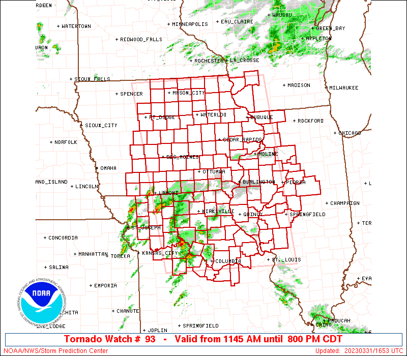
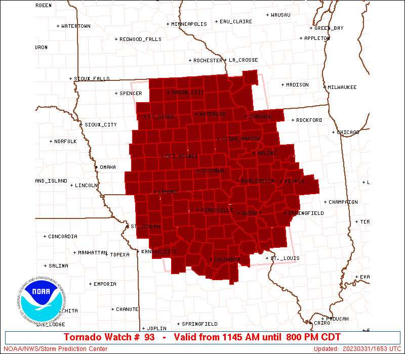
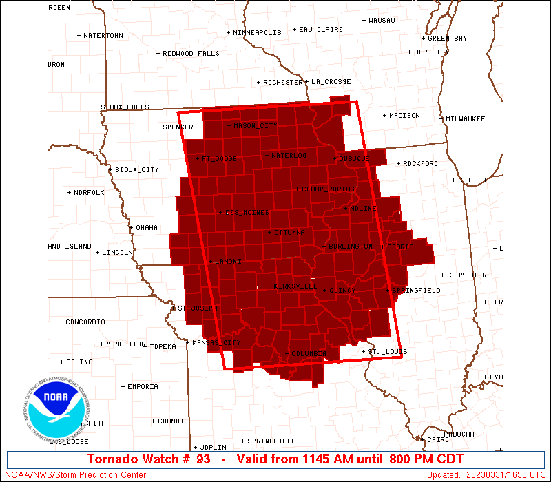
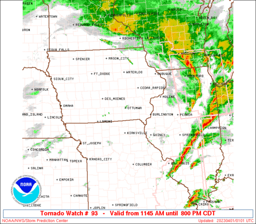
Tornado Watch Number 93
NWS Storm Prediction Center Norman OK
1145 AM CDT Fri Mar 31 2023
The NWS Storm Prediction Center has issued a
* Tornado Watch for portions of
Central and Eastern Iowa
Western Illinois
Northern and Central Missouri
Southwest Wisconsin
* Effective this Friday morning and evening from 1145 AM until
800 PM CDT.
...THIS IS A PARTICULARLY DANGEROUS SITUATION...
* Primary threats include...
Numerous tornadoes expected with a few intense tornadoes likely
Widespread large hail and isolated very large hail events to 3
inches in diameter likely
Widespread damaging wind gusts to 70 mph likely
SUMMARY...Intense supercell thunderstorms are expected to develop
this afternoon and spread eastward across the watch area.
Tornadoes, large hail, and damaging winds are all possible with this
activity. Parameters are favorable for the potential for
strong/violent tornadoes and very large hail.
The tornado watch area is approximately along and 115 statute miles
east and west of a line from 30 miles east of Jefferson City MO to
55 miles east northeast of Mason City IA. For a complete depiction
of the watch see the associated watch outline update (WOUS64 KWNS
WOU3).
PRECAUTIONARY/PREPAREDNESS ACTIONS...
REMEMBER...A Tornado Watch means conditions are favorable for
tornadoes and severe thunderstorms in and close to the watch
area. Persons in these areas should be on the lookout for
threatening weather conditions and listen for later statements
and possible warnings.
&&
AVIATION...Tornadoes and a few severe thunderstorms with hail
surface and aloft to 3 inches. Extreme turbulence and surface wind
gusts to 60 knots. A few cumulonimbi with maximum tops to 500. Mean
storm motion vector 24040.
...Hart

   SEL3

   URGENT - IMMEDIATE BROADCAST REQUESTED
   Tornado Watch Number 93
   NWS Storm Prediction Center Norman OK
   1145 AM CDT Fri Mar 31 2023

   The NWS Storm Prediction Center has issued a

   * Tornado Watch for portions of
     Central and Eastern Iowa
     Western Illinois
     Northern and Central Missouri
     Southwest Wisconsin

   * Effective this Friday morning and evening from 1145 AM until
     800 PM CDT.

   ...THIS IS A PARTICULARLY DANGEROUS SITUATION...

   * Primary threats include...
     Numerous tornadoes expected with a few intense tornadoes likely
     Widespread large hail and isolated very large hail events to 3
       inches in diameter likely
     Widespread damaging wind gusts to 70 mph likely

   SUMMARY...Intense supercell thunderstorms are expected to develop
   this afternoon and spread eastward across the watch area.
   Tornadoes, large hail, and damaging winds are all possible with this
   activity.  Parameters are favorable for the potential for
   strong/violent tornadoes and very large hail.

   The tornado watch area is approximately along and 115 statute miles
   east and west of a line from 30 miles east of Jefferson City MO to
   55 miles east northeast of Mason City IA. For a complete depiction
   of the watch see the associated watch outline update (WOUS64 KWNS
   WOU3).

   PRECAUTIONARY/PREPAREDNESS ACTIONS...

   REMEMBER...A Tornado Watch means conditions are favorable for
   tornadoes and severe thunderstorms in and close to the watch
   area. Persons in these areas should be on the lookout for
   threatening weather conditions and listen for later statements
   and possible warnings.

   &&

   AVIATION...Tornadoes and a few severe thunderstorms with hail
   surface and aloft to 3 inches. Extreme turbulence and surface wind
   gusts to 60 knots. A few cumulonimbi with maximum tops to 500. Mean
   storm motion vector 24040.

   ...Hart
 Note:
The Aviation Watch (SAW) product is an approximation to the watch area.
The actual watch is depicted by the shaded areas.
Note:
The Aviation Watch (SAW) product is an approximation to the watch area.
The actual watch is depicted by the shaded areas.
   SAW3
   WW 93 TORNADO IA IL MO WI 311645Z - 010100Z
   AXIS..115 STATUTE MILES EAST AND WEST OF LINE..
   30E JEF/JEFFERSON CITY MO/ - 55ENE MCW/MASON CITY IA/
   ..AVIATION COORDS.. 100NM E/W /32ESE COU - 46SW ODI/
   HAIL SURFACE AND ALOFT..3 INCHES. WIND GUSTS..60 KNOTS.
   MAX TOPS TO 500. MEAN STORM MOTION VECTOR 24040.

   LAT...LON 38589372 43439461 43439002 38588947

   THIS IS AN APPROXIMATION TO THE WATCH AREA.  FOR A
   COMPLETE DEPICTION OF THE WATCH SEE WOUS64 KWNS
   FOR WOU3.
Watch 93 Status Report Messages:
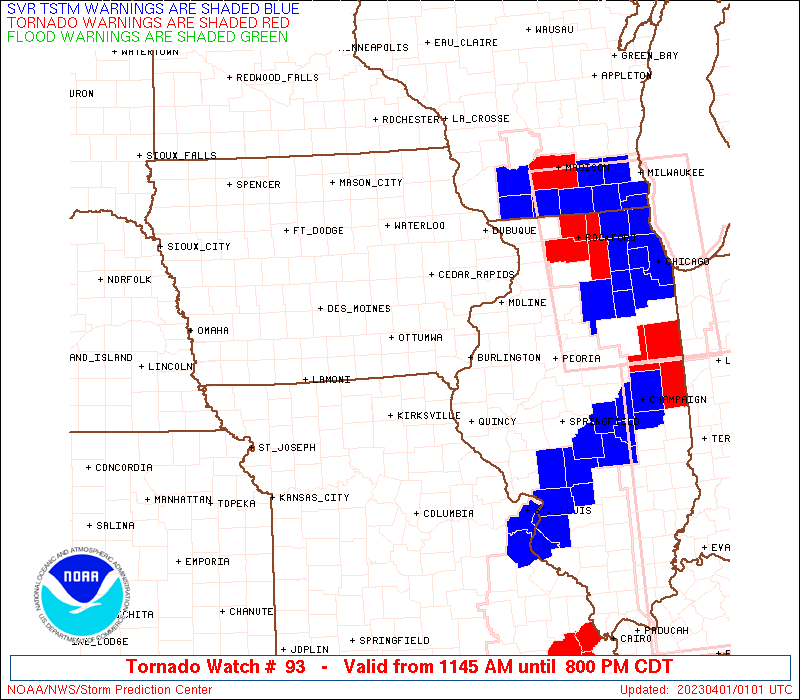
STATUS REPORT #8 ON WW 93

VALID 010100Z - 010240Z

SEVERE WEATHER THREAT CONTINUES RIGHT OF A LINE FROM 30 WSW STL
TO 5 ENE SPI TO 30 NNE PIA TO 35 ENE DBQ TO 15 SSE LSE.

..BROYLES..04/01/23

ATTN...WFO...DMX...ARX...DVN...LSX...ILX...EAX...

&&

STATUS REPORT FOR WT 93

SEVERE WEATHER THREAT CONTINUES FOR THE FOLLOWING AREAS

ILC011-021-039-107-113-115-117-123-139-147-155-173-177-203-
010240-

IL
.    ILLINOIS COUNTIES INCLUDED ARE

BUREAU		     CHRISTIAN		 DE WITT
LOGAN		     MCLEAN		 MACON
MACOUPIN	     MARSHALL		 MOULTRIE
PIATT		     PUTNAM		 SHELBY
STEPHENSON	     WOODFORD
$$


THE WATCH STATUS MESSAGE IS FOR GUIDANCE PURPOSES ONLY.  PLEASE
REFER TO WATCH COUNTY NOTIFICATION STATEMENTS FOR OFFICIAL
INFORMATION ON COUNTIES...INDEPENDENT CITIES AND MARINE ZONES
CLEARED FROM SEVERE THUNDERSTORM AND TORNADO WATCHES.
$$

STATUS REPORT #7 ON WW 93

VALID 312335Z - 010040Z

SEVERE WEATHER THREAT CONTINUES RIGHT OF A LINE FROM 10 E JEF TO
20 SSE BRL TO 15 SSW DBQ TO 50 W LNR TO 35 WSW LSE.

..BROYLES..03/31/23

ATTN...WFO...DMX...ARX...DVN...LSX...ILX...EAX...

&&

STATUS REPORT FOR WT 93

SEVERE WEATHER THREAT CONTINUES FOR THE FOLLOWING AREAS

ILC009-011-013-015-017-021-039-057-061-071-073-083-085-095-107-
109-113-115-117-123-125-129-131-137-139-143-147-149-155-161-167-
169-171-173-175-177-179-187-195-203-010040-

IL
.    ILLINOIS COUNTIES INCLUDED ARE

BROWN		     BUREAU		 CALHOUN
CARROLL 	     CASS		 CHRISTIAN
DE WITT 	     FULTON		 GREENE
HENDERSON	     HENRY		 JERSEY
JO DAVIESS	     KNOX		 LOGAN
MCDONOUGH	     MCLEAN		 MACON
MACOUPIN	     MARSHALL		 MASON
MENARD		     MERCER		 MORGAN
MOULTRIE	     PEORIA		 PIATT
PIKE		     PUTNAM		 ROCK ISLAND
SANGAMON	     SCHUYLER		 SCOTT
SHELBY		     STARK		 STEPHENSON
TAZEWELL	     WARREN		 WHITESIDE
WOODFORD
$$


IAC045-061-097-163-010040-

IA
.    IOWA COUNTIES INCLUDED ARE

CLINTON 	     DUBUQUE		 JACKSON
SCOTT
$$


MOC073-113-139-163-219-010040-

MO
.    MISSOURI COUNTIES INCLUDED ARE

GASCONADE	     LINCOLN		 MONTGOMERY
PIKE		     WARREN
$$


WIC023-043-103-010040-

WI
.    WISCONSIN COUNTIES INCLUDED ARE

CRAWFORD	     GRANT		 RICHLAND
$$


THE WATCH STATUS MESSAGE IS FOR GUIDANCE PURPOSES ONLY.  PLEASE
REFER TO WATCH COUNTY NOTIFICATION STATEMENTS FOR OFFICIAL
INFORMATION ON COUNTIES...INDEPENDENT CITIES AND MARINE ZONES
CLEARED FROM SEVERE THUNDERSTORM AND TORNADO WATCHES.
$$

STATUS REPORT #6 ON WW 93

VALID 312235Z - 312340Z

SEVERE WEATHER THREAT CONTINUES RIGHT OF A LINE FROM 30 SSW JEF
TO 15 ENE OTM TO 20 NNW ALO TO 35 NNE MCW.

..BROYLES..03/31/23

ATTN...WFO...DMX...ARX...DVN...LSX...ILX...EAX...

&&

STATUS REPORT FOR WT 93

SEVERE WEATHER THREAT CONTINUES FOR THE FOLLOWING AREAS

ILC001-009-011-013-015-017-057-061-067-071-073-083-085-095-107-
109-113-117-123-125-129-131-137-143-149-155-161-167-169-171-175-
177-179-187-195-203-312340-

IL
.    ILLINOIS COUNTIES INCLUDED ARE

ADAMS		     BROWN		 BUREAU
CALHOUN 	     CARROLL		 CASS
FULTON		     GREENE		 HANCOCK
HENDERSON	     HENRY		 JERSEY
JO DAVIESS	     KNOX		 LOGAN
MCDONOUGH	     MCLEAN		 MACOUPIN
MARSHALL	     MASON		 MENARD
MERCER		     MORGAN		 PEORIA
PIKE		     PUTNAM		 ROCK ISLAND
SANGAMON	     SCHUYLER		 SCOTT
STARK		     STEPHENSON 	 TAZEWELL
WARREN		     WHITESIDE		 WOODFORD
$$


IAC005-011-013-017-019-031-037-043-045-055-057-061-065-087-089-
095-097-101-103-105-107-111-113-115-131-139-163-177-183-191-
312340-

IA
.    IOWA COUNTIES INCLUDED ARE

ALLAMAKEE	     BENTON		 BLACK HAWK
BREMER		     BUCHANAN		 CEDAR
CHICKASAW	     CLAYTON		 CLINTON
DELAWARE	     DES MOINES 	 DUBUQUE
FAYETTE 	     HENRY		 HOWARD
IOWA		     JACKSON		 JEFFERSON
JOHNSON 	     JONES		 KEOKUK
LEE		     LINN		 LOUISA
MITCHELL	     MUSCATINE		 SCOTT
VAN BUREN	     WASHINGTON 	 WINNESHIEK
$$


MOC007-027-045-073-103-111-113-127-137-139-151-163-173-199-205-
219-312340-

MO
.    MISSOURI COUNTIES INCLUDED ARE

AUDRAIN 	     CALLAWAY		 CLARK
GASCONADE	     KNOX		 LEWIS
LINCOLN 	     MARION		 MONROE
MONTGOMERY	     OSAGE		 PIKE
RALLS		     SCOTLAND		 SHELBY
WARREN
$$


WIC023-043-103-312340-

WI
.    WISCONSIN COUNTIES INCLUDED ARE

CRAWFORD	     GRANT		 RICHLAND
$$


THE WATCH STATUS MESSAGE IS FOR GUIDANCE PURPOSES ONLY.  PLEASE
REFER TO WATCH COUNTY NOTIFICATION STATEMENTS FOR OFFICIAL
INFORMATION ON COUNTIES...INDEPENDENT CITIES AND MARINE ZONES
CLEARED FROM SEVERE THUNDERSTORM AND TORNADO WATCHES.
$$

STATUS REPORT #5 ON WW 93

VALID 312125Z - 312240Z

SEVERE WEATHER THREAT CONTINUES RIGHT OF A LINE FROM 35 ESE SZL
TO 25 WNW IRK TO 35 ESE FOD TO 15 SE FRM.

..BROYLES..03/31/23

ATTN...WFO...DMX...ARX...DVN...LSX...ILX...EAX...

&&

STATUS REPORT FOR WT 93

SEVERE WEATHER THREAT CONTINUES FOR THE FOLLOWING AREAS

ILC001-009-011-013-015-017-057-061-067-071-073-083-085-095-107-
109-113-117-123-125-129-131-137-143-149-155-161-167-169-171-175-
177-179-187-195-203-312240-

IL
.    ILLINOIS COUNTIES INCLUDED ARE

ADAMS		     BROWN		 BUREAU
CALHOUN 	     CARROLL		 CASS
FULTON		     GREENE		 HANCOCK
HENDERSON	     HENRY		 JERSEY
JO DAVIESS	     KNOX		 LOGAN
MCDONOUGH	     MCLEAN		 MACOUPIN
MARSHALL	     MASON		 MENARD
MERCER		     MORGAN		 PEORIA
PIKE		     PUTNAM		 ROCK ISLAND
SANGAMON	     SCHUYLER		 SCOTT
STARK		     STEPHENSON 	 TAZEWELL
WARREN		     WHITESIDE		 WOODFORD
$$


IAC005-007-011-013-017-019-023-031-033-037-043-045-051-055-057-
061-065-067-069-075-081-083-087-089-095-097-099-101-103-105-107-
111-113-115-123-125-127-131-135-139-157-163-171-177-179-183-189-
191-195-312240-

IA
.    IOWA COUNTIES INCLUDED ARE

ALLAMAKEE	     APPANOOSE		 BENTON
BLACK HAWK	     BREMER		 BUCHANAN
BUTLER		     CEDAR		 CERRO GORDO
CHICKASAW	     CLAYTON		 CLINTON
DAVIS		     DELAWARE		 DES MOINES
DUBUQUE 	     FAYETTE		 FLOYD
FRANKLIN	     GRUNDY		 HANCOCK
HARDIN		     HENRY		 HOWARD
IOWA		     JACKSON		 JASPER
JEFFERSON	     JOHNSON		 JONES
KEOKUK		     LEE		 LINN
LOUISA		     MAHASKA		 MARION
MARSHALL	     MITCHELL		 MONROE
MUSCATINE	     POWESHIEK		 SCOTT
TAMA		     VAN BUREN		 WAPELLO
WASHINGTON	     WINNEBAGO		 WINNESHIEK
WORTH
$$


MOC001-007-019-027-045-051-053-073-089-103-111-113-121-127-135-
137-139-151-163-173-175-197-199-205-219-312240-

MO
.    MISSOURI COUNTIES INCLUDED ARE

ADAIR		     AUDRAIN		 BOONE
CALLAWAY	     CLARK		 COLE
COOPER		     GASCONADE		 HOWARD
KNOX		     LEWIS		 LINCOLN
MACON		     MARION		 MONITEAU
MONROE		     MONTGOMERY 	 OSAGE
PIKE		     RALLS		 RANDOLPH
SCHUYLER	     SCOTLAND		 SHELBY
WARREN
$$


WIC023-043-103-312240-

WI
.    WISCONSIN COUNTIES INCLUDED ARE

CRAWFORD	     GRANT		 RICHLAND
$$


THE WATCH STATUS MESSAGE IS FOR GUIDANCE PURPOSES ONLY.  PLEASE
REFER TO WATCH COUNTY NOTIFICATION STATEMENTS FOR OFFICIAL
INFORMATION ON COUNTIES...INDEPENDENT CITIES AND MARINE ZONES
CLEARED FROM SEVERE THUNDERSTORM AND TORNADO WATCHES.
$$

STATUS REPORT #4 ON WW 93

VALID 312035Z - 312140Z

SEVERE WEATHER THREAT CONTINUES RIGHT OF A LINE FROM 25 ESE MKC
TO 25 NNW CDJ TO 30 WSW OXV TO 35 SE FOD TO 35 NNW MCW.

..WENDT..03/31/23

ATTN...WFO...DMX...ARX...DVN...LSX...ILX...EAX...

&&

STATUS REPORT FOR WT 93

SEVERE WEATHER THREAT CONTINUES FOR THE FOLLOWING AREAS

ILC001-009-011-013-015-017-057-061-067-071-073-083-085-095-107-
109-113-117-123-125-129-131-137-143-149-155-161-167-169-171-175-
177-179-187-195-203-312140-

IL
.    ILLINOIS COUNTIES INCLUDED ARE

ADAMS		     BROWN		 BUREAU
CALHOUN 	     CARROLL		 CASS
FULTON		     GREENE		 HANCOCK
HENDERSON	     HENRY		 JERSEY
JO DAVIESS	     KNOX		 LOGAN
MCDONOUGH	     MCLEAN		 MACOUPIN
MARSHALL	     MASON		 MENARD
MERCER		     MORGAN		 PEORIA
PIKE		     PUTNAM		 ROCK ISLAND
SANGAMON	     SCHUYLER		 SCOTT
STARK		     STEPHENSON 	 TAZEWELL
WARREN		     WHITESIDE		 WOODFORD
$$


IAC005-007-011-013-017-019-023-031-033-037-039-043-045-051-053-
055-057-061-065-067-069-075-079-081-083-087-089-095-097-099-101-
103-105-107-111-113-115-117-123-125-127-131-135-139-153-157-163-
169-171-177-179-181-183-185-189-191-195-197-312140-

IA
.    IOWA COUNTIES INCLUDED ARE

ALLAMAKEE	     APPANOOSE		 BENTON
BLACK HAWK	     BREMER		 BUCHANAN
BUTLER		     CEDAR		 CERRO GORDO
CHICKASAW	     CLARKE		 CLAYTON
CLINTON 	     DAVIS		 DECATUR
DELAWARE	     DES MOINES 	 DUBUQUE
FAYETTE 	     FLOYD		 FRANKLIN
GRUNDY		     HAMILTON		 HANCOCK
HARDIN		     HENRY		 HOWARD
IOWA		     JACKSON		 JASPER
JEFFERSON	     JOHNSON		 JONES
KEOKUK		     LEE		 LINN
LOUISA		     LUCAS		 MAHASKA
MARION		     MARSHALL		 MITCHELL
MONROE		     MUSCATINE		 POLK
POWESHIEK	     SCOTT		 STORY
TAMA		     VAN BUREN		 WAPELLO
WARREN		     WASHINGTON 	 WAYNE
WINNEBAGO	     WINNESHIEK 	 WORTH
WRIGHT
$$


MOC001-007-019-025-027-033-041-045-051-053-061-073-079-089-103-
107-111-113-115-117-121-127-129-135-137-139-151-159-163-171-173-
175-177-195-197-199-205-211-219-312140-

MO
.    MISSOURI COUNTIES INCLUDED ARE

ADAIR		     AUDRAIN		 BOONE
CALDWELL	     CALLAWAY		 CARROLL
CHARITON	     CLARK		 COLE
COOPER		     DAVIESS		 GASCONADE
GRUNDY		     HOWARD		 KNOX
LAFAYETTE	     LEWIS		 LINCOLN
LINN		     LIVINGSTON 	 MACON
MARION		     MERCER		 MONITEAU
MONROE		     MONTGOMERY 	 OSAGE
PETTIS		     PIKE		 PUTNAM
RALLS		     RANDOLPH		 RAY
SALINE		     SCHUYLER		 SCOTLAND
SHELBY		     SULLIVAN		 WARREN
$$


WIC023-043-103-312140-

WI
.    WISCONSIN COUNTIES INCLUDED ARE

CRAWFORD	     GRANT		 RICHLAND
$$


THE WATCH STATUS MESSAGE IS FOR GUIDANCE PURPOSES ONLY.  PLEASE
REFER TO WATCH COUNTY NOTIFICATION STATEMENTS FOR OFFICIAL
INFORMATION ON COUNTIES...INDEPENDENT CITIES AND MARINE ZONES
CLEARED FROM SEVERE THUNDERSTORM AND TORNADO WATCHES.
$$

STATUS REPORT #3 ON WW 93

VALID 311925Z - 312030Z

SEVERE WEATHER THREAT CONTINUES RIGHT OF A LINE FROM 25 WSW CDJ
TO 30 S DSM TO 15 SSE FRM.

FOR ADDITIONAL INFORMATION SEE MESOSCALE DISCUSSION 398

..SMITH..03/31/23

ATTN...WFO...DMX...ARX...DVN...LSX...ILX...EAX...

&&

STATUS REPORT FOR WT 93

SEVERE WEATHER THREAT CONTINUES FOR THE FOLLOWING AREAS

ILC001-009-011-013-015-017-057-061-067-071-073-083-085-095-107-
109-113-117-123-125-129-131-137-143-149-155-161-167-169-171-175-
177-179-187-195-203-312030-

IL
.    ILLINOIS COUNTIES INCLUDED ARE

ADAMS		     BROWN		 BUREAU
CALHOUN 	     CARROLL		 CASS
FULTON		     GREENE		 HANCOCK
HENDERSON	     HENRY		 JERSEY
JO DAVIESS	     KNOX		 LOGAN
MCDONOUGH	     MCLEAN		 MACOUPIN
MARSHALL	     MASON		 MENARD
MERCER		     MORGAN		 PEORIA
PIKE		     PUTNAM		 ROCK ISLAND
SANGAMON	     SCHUYLER		 SCOTT
STARK		     STEPHENSON 	 TAZEWELL
WARREN		     WHITESIDE		 WOODFORD
$$


IAC005-007-011-013-015-017-019-023-031-033-037-039-043-045-049-
051-053-055-057-061-065-067-069-075-079-081-083-087-089-095-097-
099-101-103-105-107-111-113-115-117-121-123-125-127-131-135-139-
153-157-163-169-171-177-179-181-183-185-189-191-195-197-
312030-

IA
.    IOWA COUNTIES INCLUDED ARE

ALLAMAKEE	     APPANOOSE		 BENTON
BLACK HAWK	     BOONE		 BREMER
BUCHANAN	     BUTLER		 CEDAR
CERRO GORDO	     CHICKASAW		 CLARKE
CLAYTON 	     CLINTON		 DALLAS
DAVIS		     DECATUR		 DELAWARE
DES MOINES	     DUBUQUE		 FAYETTE
FLOYD		     FRANKLIN		 GRUNDY
HAMILTON	     HANCOCK		 HARDIN
HENRY		     HOWARD		 IOWA
JACKSON 	     JASPER		 JEFFERSON
JOHNSON 	     JONES		 KEOKUK
LEE		     LINN		 LOUISA
LUCAS		     MADISON		 MAHASKA
MARION		     MARSHALL		 MITCHELL
MONROE		     MUSCATINE		 POLK
POWESHIEK	     SCOTT		 STORY
TAMA		     VAN BUREN		 WAPELLO
WARREN		     WASHINGTON 	 WAYNE
WINNEBAGO	     WINNESHIEK 	 WORTH
WRIGHT
$$


MOC001-007-019-025-027-033-041-045-051-053-061-073-079-081-089-
103-107-111-113-115-117-121-127-129-135-137-139-151-159-163-171-
173-175-177-195-197-199-205-211-219-312030-

MO
.    MISSOURI COUNTIES INCLUDED ARE

ADAIR		     AUDRAIN		 BOONE
CALDWELL	     CALLAWAY		 CARROLL
CHARITON	     CLARK		 COLE
COOPER		     DAVIESS		 GASCONADE
GRUNDY		     HARRISON		 HOWARD
KNOX		     LAFAYETTE		 LEWIS
LINCOLN 	     LINN		 LIVINGSTON
MACON		     MARION		 MERCER
MONITEAU	     MONROE		 MONTGOMERY
OSAGE		     PETTIS		 PIKE
PUTNAM		     RALLS		 RANDOLPH
RAY		     SALINE		 SCHUYLER
SCOTLAND	     SHELBY		 SULLIVAN
WARREN
$$


WIC023-043-103-312030-

WI
.    WISCONSIN COUNTIES INCLUDED ARE

CRAWFORD	     GRANT		 RICHLAND
$$


THE WATCH STATUS MESSAGE IS FOR GUIDANCE PURPOSES ONLY.  PLEASE
REFER TO WATCH COUNTY NOTIFICATION STATEMENTS FOR OFFICIAL
INFORMATION ON COUNTIES...INDEPENDENT CITIES AND MARINE ZONES
CLEARED FROM SEVERE THUNDERSTORM AND TORNADO WATCHES.
$$

STATUS REPORT #2 ON WW 93

VALID 311820Z - 311940Z

THE SEVERE WEATHER THREAT CONTINUES ACROSS THE ENTIRE WATCH AREA.

..WENDT..03/31/23

ATTN...WFO...DMX...ARX...DVN...LSX...ILX...EAX...

&&

STATUS REPORT FOR WT 93

SEVERE WEATHER THREAT CONTINUES FOR THE FOLLOWING AREAS

ILC001-009-011-013-015-017-057-061-067-071-073-083-085-095-107-
109-113-117-123-125-129-131-137-143-149-155-161-167-169-171-175-
177-179-187-195-203-311940-

IL
.    ILLINOIS COUNTIES INCLUDED ARE

ADAMS		     BROWN		 BUREAU
CALHOUN 	     CARROLL		 CASS
FULTON		     GREENE		 HANCOCK
HENDERSON	     HENRY		 JERSEY
JO DAVIESS	     KNOX		 LOGAN
MCDONOUGH	     MCLEAN		 MACOUPIN
MARSHALL	     MASON		 MENARD
MERCER		     MORGAN		 PEORIA
PIKE		     PUTNAM		 ROCK ISLAND
SANGAMON	     SCHUYLER		 SCOTT
STARK		     STEPHENSON 	 TAZEWELL
WARREN		     WHITESIDE		 WOODFORD
$$


IAC001-003-005-007-011-013-015-017-019-023-031-033-037-039-043-
045-049-051-053-055-057-061-065-067-069-073-075-077-079-081-083-
087-089-091-095-097-099-101-103-105-107-111-113-115-117-121-123-
125-127-131-135-139-153-157-159-163-169-171-173-175-177-179-181-
183-185-187-189-191-195-197-311940-

IA
.    IOWA COUNTIES INCLUDED ARE

ADAIR		     ADAMS		 ALLAMAKEE
APPANOOSE	     BENTON		 BLACK HAWK
BOONE		     BREMER		 BUCHANAN
BUTLER		     CEDAR		 CERRO GORDO
CHICKASAW	     CLARKE		 CLAYTON
CLINTON 	     DALLAS		 DAVIS
DECATUR 	     DELAWARE		 DES MOINES
DUBUQUE 	     FAYETTE		 FLOYD
FRANKLIN	     GREENE		 GRUNDY
GUTHRIE 	     HAMILTON		 HANCOCK
HARDIN		     HENRY		 HOWARD
HUMBOLDT	     IOWA		 JACKSON
JASPER		     JEFFERSON		 JOHNSON
JONES		     KEOKUK		 LEE
LINN		     LOUISA		 LUCAS
MADISON 	     MAHASKA		 MARION
MARSHALL	     MITCHELL		 MONROE
MUSCATINE	     POLK		 POWESHIEK
RINGGOLD	     SCOTT		 STORY
TAMA		     TAYLOR		 UNION
VAN BUREN	     WAPELLO		 WARREN
WASHINGTON	     WAYNE		 WEBSTER
WINNEBAGO	     WINNESHIEK 	 WORTH
WRIGHT
$$


MOC001-007-019-025-027-033-041-045-049-051-053-061-063-073-075-
079-081-089-103-107-111-113-115-117-121-127-129-135-137-139-151-
159-163-171-173-175-177-195-197-199-205-211-219-227-311940-

MO
.    MISSOURI COUNTIES INCLUDED ARE

ADAIR		     AUDRAIN		 BOONE
CALDWELL	     CALLAWAY		 CARROLL
CHARITON	     CLARK		 CLINTON
COLE		     COOPER		 DAVIESS
DEKALB		     GASCONADE		 GENTRY
GRUNDY		     HARRISON		 HOWARD
KNOX		     LAFAYETTE		 LEWIS
LINCOLN 	     LINN		 LIVINGSTON
MACON		     MARION		 MERCER
MONITEAU	     MONROE		 MONTGOMERY
OSAGE		     PETTIS		 PIKE
PUTNAM		     RALLS		 RANDOLPH
RAY		     SALINE		 SCHUYLER
SCOTLAND	     SHELBY		 SULLIVAN
WARREN		     WORTH
$$


WIC023-043-103-311940-

WI
.    WISCONSIN COUNTIES INCLUDED ARE

CRAWFORD	     GRANT		 RICHLAND
$$


THE WATCH STATUS MESSAGE IS FOR GUIDANCE PURPOSES ONLY.  PLEASE
REFER TO WATCH COUNTY NOTIFICATION STATEMENTS FOR OFFICIAL
INFORMATION ON COUNTIES...INDEPENDENT CITIES AND MARINE ZONES
CLEARED FROM SEVERE THUNDERSTORM AND TORNADO WATCHES.
$$

STATUS REPORT #1 ON WW 93

VALID 311715Z - 311900Z

THE SEVERE WEATHER THREAT CONTINUES ACROSS THE ENTIRE WATCH AREA.

..SMITH..03/31/23

ATTN...WFO...DMX...ARX...DVN...LSX...ILX...EAX...

&&

STATUS REPORT FOR WT 93

SEVERE WEATHER THREAT CONTINUES FOR THE FOLLOWING AREAS

ILC001-009-011-013-015-017-057-061-067-071-073-083-085-095-107-
109-113-117-123-125-129-131-137-143-149-155-161-167-169-171-175-
177-179-187-195-203-311900-

IL
.    ILLINOIS COUNTIES INCLUDED ARE

ADAMS		     BROWN		 BUREAU
CALHOUN 	     CARROLL		 CASS
FULTON		     GREENE		 HANCOCK
HENDERSON	     HENRY		 JERSEY
JO DAVIESS	     KNOX		 LOGAN
MCDONOUGH	     MCLEAN		 MACOUPIN
MARSHALL	     MASON		 MENARD
MERCER		     MORGAN		 PEORIA
PIKE		     PUTNAM		 ROCK ISLAND
SANGAMON	     SCHUYLER		 SCOTT
STARK		     STEPHENSON 	 TAZEWELL
WARREN		     WHITESIDE		 WOODFORD
$$


IAC001-003-005-007-011-013-015-017-019-023-031-033-037-039-043-
045-049-051-053-055-057-061-065-067-069-073-075-077-079-081-083-
087-089-091-095-097-099-101-103-105-107-111-113-115-117-121-123-
125-127-131-135-139-153-157-159-163-169-171-173-175-177-179-181-
183-185-187-189-191-195-197-311900-

IA
.    IOWA COUNTIES INCLUDED ARE

ADAIR		     ADAMS		 ALLAMAKEE
APPANOOSE	     BENTON		 BLACK HAWK
BOONE		     BREMER		 BUCHANAN
BUTLER		     CEDAR		 CERRO GORDO
CHICKASAW	     CLARKE		 CLAYTON
CLINTON 	     DALLAS		 DAVIS
DECATUR 	     DELAWARE		 DES MOINES
DUBUQUE 	     FAYETTE		 FLOYD
FRANKLIN	     GREENE		 GRUNDY
GUTHRIE 	     HAMILTON		 HANCOCK
HARDIN		     HENRY		 HOWARD
HUMBOLDT	     IOWA		 JACKSON
JASPER		     JEFFERSON		 JOHNSON
JONES		     KEOKUK		 LEE
LINN		     LOUISA		 LUCAS
MADISON 	     MAHASKA		 MARION
MARSHALL	     MITCHELL		 MONROE
MUSCATINE	     POLK		 POWESHIEK
RINGGOLD	     SCOTT		 STORY
TAMA		     TAYLOR		 UNION
VAN BUREN	     WAPELLO		 WARREN
WASHINGTON	     WAYNE		 WEBSTER
WINNEBAGO	     WINNESHIEK 	 WORTH
WRIGHT
$$


MOC001-007-019-025-027-033-041-045-049-051-053-061-063-073-075-
079-081-089-103-107-111-113-115-117-121-127-129-135-137-139-151-
159-163-171-173-175-177-195-197-199-205-211-219-227-311900-

MO
.    MISSOURI COUNTIES INCLUDED ARE

ADAIR		     AUDRAIN		 BOONE
CALDWELL	     CALLAWAY		 CARROLL
CHARITON	     CLARK		 CLINTON
COLE		     COOPER		 DAVIESS
DEKALB		     GASCONADE		 GENTRY
GRUNDY		     HARRISON		 HOWARD
KNOX		     LAFAYETTE		 LEWIS
LINCOLN 	     LINN		 LIVINGSTON
MACON		     MARION		 MERCER
MONITEAU	     MONROE		 MONTGOMERY
OSAGE		     PETTIS		 PIKE
PUTNAM		     RALLS		 RANDOLPH
RAY		     SALINE		 SCHUYLER
SCOTLAND	     SHELBY		 SULLIVAN
WARREN		     WORTH
$$


WIC023-043-103-311900-

WI
.    WISCONSIN COUNTIES INCLUDED ARE

CRAWFORD	     GRANT		 RICHLAND
$$


THE WATCH STATUS MESSAGE IS FOR GUIDANCE PURPOSES ONLY.  PLEASE
REFER TO WATCH COUNTY NOTIFICATION STATEMENTS FOR OFFICIAL
INFORMATION ON COUNTIES...INDEPENDENT CITIES AND MARINE ZONES
CLEARED FROM SEVERE THUNDERSTORM AND TORNADO WATCHES.
$$
Note:
Click for Complete Product Text.
Tornadoes
Probability of 2 or more tornadoes
|
High (>95%)
|
Probability of 1 or more strong (EF2-EF5) tornadoes
|
High (90%)
|
Wind
Probability of 10 or more severe wind events
|
High (90%)
|
Probability of 1 or more wind events > 65 knots
|
Low (10%)
|
Hail
Probability of 10 or more severe hail events
|
High (80%)
|
Probability of 1 or more hailstones > 2 inches
|
Mod (60%)
|
Combined Severe Hail/Wind
Probability of 6 or more combined severe hail/wind events
|
High (>95%)
|
For each watch, probabilities for particular events inside the watch
(listed above in each table) are determined by the issuing forecaster.
The "Low" category contains probability values ranging from less than 2%
to 20% (EF2-EF5 tornadoes), less than 5% to 20% (all other probabilities),
"Moderate" from 30% to 60%, and "High" from 70% to greater than 95%.
High values are bolded and lighter in color to provide awareness of
an increased threat for a particular event.


 @NWSSPC