 Note:
The expiration time in the watch graphic is amended if the watch is
replaced, cancelled or extended.
Note:
Note:
The expiration time in the watch graphic is amended if the watch is
replaced, cancelled or extended.
Note: Click for
Watch Status Reports.
SEL6
URGENT - IMMEDIATE BROADCAST REQUESTED
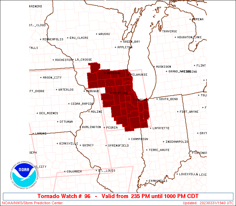
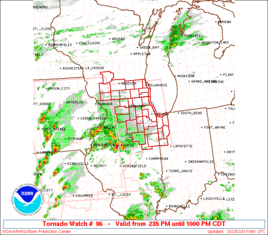
Tornado Watch Number 96
NWS Storm Prediction Center Norman OK
235 PM CDT Fri Mar 31 2023
The NWS Storm Prediction Center has issued a
* Tornado Watch for portions of
Northeast Illinois
Northwest Indiana
Southern Wisconsin
Lake Michigan
* Effective this Friday afternoon and evening from 235 PM until
1000 PM CDT.
* Primary threats include...
A few tornadoes likely with a couple intense tornadoes possible
Scattered damaging wind gusts to 70 mph likely
Scattered large hail events to 1.5 inches in diameter possible
SUMMARY...A cluster of intense thunderstorms over northwest Illinois
will track eastward across the watch area this afternoon, posing a
risk of large hail, damaging wind gusts, and a few tornadoes.
Another line of storms will threaten the area later this afternoon
with a second round of severe/tornado threat.
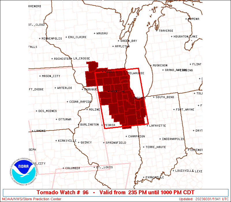
The tornado watch area is approximately along and 70 statute miles
east and west of a line from 30 miles west northwest of Milwaukee WI
to 65 miles south southeast of Marseilles IL. For a complete
depiction of the watch see the associated watch outline update
(WOUS64 KWNS WOU6).
PRECAUTIONARY/PREPAREDNESS ACTIONS...
REMEMBER...A Tornado Watch means conditions are favorable for
tornadoes and severe thunderstorms in and close to the watch
area. Persons in these areas should be on the lookout for
threatening weather conditions and listen for later statements
and possible warnings.
&&
OTHER WATCH INFORMATION...CONTINUE...WW 93...WW 94...WW 95...
AVIATION...Tornadoes and a few severe thunderstorms with hail
surface and aloft to 1.5 inches. Extreme turbulence and surface wind
gusts to 60 knots. A few cumulonimbi with maximum tops to 500. Mean
storm motion vector 25040.
...Hart
   SEL6

   URGENT - IMMEDIATE BROADCAST REQUESTED
   Tornado Watch Number 96
   NWS Storm Prediction Center Norman OK
   235 PM CDT Fri Mar 31 2023

   The NWS Storm Prediction Center has issued a

   * Tornado Watch for portions of
     Northeast Illinois
     Northwest Indiana
     Southern Wisconsin
     Lake Michigan

   * Effective this Friday afternoon and evening from 235 PM until
     1000 PM CDT.

   * Primary threats include...
     A few tornadoes likely with a couple intense tornadoes possible
     Scattered damaging wind gusts to 70 mph likely
     Scattered large hail events to 1.5 inches in diameter possible

   SUMMARY...A cluster of intense thunderstorms over northwest Illinois
   will track eastward across the watch area this afternoon, posing a
   risk of large hail, damaging wind gusts, and a few tornadoes.
   Another line of storms will threaten the area later this afternoon
   with a second round of severe/tornado threat.

   The tornado watch area is approximately along and 70 statute miles
   east and west of a line from 30 miles west northwest of Milwaukee WI
   to 65 miles south southeast of Marseilles IL. For a complete
   depiction of the watch see the associated watch outline update
   (WOUS64 KWNS WOU6).

   PRECAUTIONARY/PREPAREDNESS ACTIONS...

   REMEMBER...A Tornado Watch means conditions are favorable for
   tornadoes and severe thunderstorms in and close to the watch
   area. Persons in these areas should be on the lookout for
   threatening weather conditions and listen for later statements
   and possible warnings.

   &&

   OTHER WATCH INFORMATION...CONTINUE...WW 93...WW 94...WW 95...

   AVIATION...Tornadoes and a few severe thunderstorms with hail
   surface and aloft to 1.5 inches. Extreme turbulence and surface wind
   gusts to 60 knots. A few cumulonimbi with maximum tops to 500. Mean
   storm motion vector 25040.

   ...Hart
 Note:
The Aviation Watch (SAW) product is an approximation to the watch area.
The actual watch is depicted by the shaded areas.
Note:
The Aviation Watch (SAW) product is an approximation to the watch area.
The actual watch is depicted by the shaded areas.
   SAW6
   WW 96 TORNADO IL IN WI LM 311935Z - 010300Z
   AXIS..70 STATUTE MILES EAST AND WEST OF LINE..
   30WNW MKE/MILWAUKEE WI/ - 65SSE MMO/MARSEILLES IL/
   ..AVIATION COORDS.. 60NM E/W /7W BAE - 52W BVT/
   HAIL SURFACE AND ALOFT..1.5 INCHES. WIND GUSTS..60 KNOTS.
   MAX TOPS TO 500. MEAN STORM MOTION VECTOR 25040.

   LAT...LON 43118706 40498687 40498954 43118984

   THIS IS AN APPROXIMATION TO THE WATCH AREA.  FOR A
   COMPLETE DEPICTION OF THE WATCH SEE WOUS64 KWNS
   FOR WOU6.
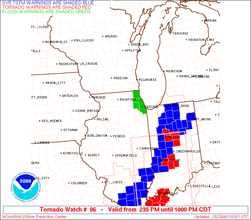
Watch 96 Status Report Messages:
STATUS REPORT #5 ON WW 96

VALID 010100Z - 010240Z

SEVERE WEATHER THREAT CONTINUES RIGHT OF A LINE FROM 10 S PIA TO
15 W MMO TO 5 SSW RFD TO 10 W MSN.

..BROYLES..04/01/23

ATTN...WFO...LOT...MKX...

&&

STATUS REPORT FOR WT 96

SEVERE WEATHER THREAT CONTINUES FOR THE FOLLOWING AREAS

ILC007-031-037-043-053-063-075-089-091-093-097-099-103-105-111-
141-197-201-010240-

IL
.    ILLINOIS COUNTIES INCLUDED ARE

BOONE		     COOK		 DE KALB
DUPAGE		     FORD		 GRUNDY
IROQUOIS	     KANE		 KANKAKEE
KENDALL 	     LAKE		 LA SALLE
LEE		     LIVINGSTON 	 MCHENRY
OGLE		     WILL		 WINNEBAGO
$$


INC007-073-089-111-127-010240-

IN
.    INDIANA COUNTIES INCLUDED ARE

BENTON		     JASPER		 LAKE
NEWTON		     PORTER
$$


WIC025-045-049-055-059-065-079-101-105-111-127-133-010240-

WI
.    WISCONSIN COUNTIES INCLUDED ARE

DANE		     GREEN		 IOWA
JEFFERSON	     KENOSHA		 LAFAYETTE
MILWAUKEE	     RACINE		 ROCK
SAUK		     WALWORTH		 WAUKESHA
$$


LMZ645-646-740-741-742-743-744-745-010240-

CW

.    ADJACENT COASTAL WATERS INCLUDED ARE

NORTH POINT LIGHT TO WIND POINT WI

WIND POINT WI TO WINTHROP HARBOR IL

WINTHROP HARBOR TO WILMETTE HARBOR IL

WILMETTE HARBOR TO NORTHERLY ISLAND IL

NORTHERLY ISLAND TO CALUMET HARBOR IL

CALUMET HARBOR IL TO GARY IN

GARY TO BURNS HARBOR IN

BURNS HARBOR TO MICHIGAN CITY IN

$$
THE WATCH STATUS MESSAGE IS FOR GUIDANCE PURPOSES ONLY.  PLEASE
REFER TO WATCH COUNTY NOTIFICATION STATEMENTS FOR OFFICIAL
INFORMATION ON COUNTIES...INDEPENDENT CITIES AND MARINE ZONES
CLEARED FROM SEVERE THUNDERSTORM AND TORNADO WATCHES.
$$

STATUS REPORT #4 ON WW 96

VALID 312330Z - 010040Z

THE SEVERE WEATHER THREAT CONTINUES ACROSS THE ENTIRE WATCH AREA.

..BROYLES..03/31/23

ATTN...WFO...LOT...MKX...

&&

STATUS REPORT FOR WT 96

SEVERE WEATHER THREAT CONTINUES FOR THE FOLLOWING AREAS

ILC007-031-037-043-053-063-075-089-091-093-097-099-103-105-111-
141-197-201-010040-

IL
.    ILLINOIS COUNTIES INCLUDED ARE

BOONE		     COOK		 DE KALB
DUPAGE		     FORD		 GRUNDY
IROQUOIS	     KANE		 KANKAKEE
KENDALL 	     LAKE		 LA SALLE
LEE		     LIVINGSTON 	 MCHENRY
OGLE		     WILL		 WINNEBAGO
$$


INC007-073-089-111-127-010040-

IN
.    INDIANA COUNTIES INCLUDED ARE

BENTON		     JASPER		 LAKE
NEWTON		     PORTER
$$


WIC025-045-049-055-059-065-079-101-105-111-127-133-010040-

WI
.    WISCONSIN COUNTIES INCLUDED ARE

DANE		     GREEN		 IOWA
JEFFERSON	     KENOSHA		 LAFAYETTE
MILWAUKEE	     RACINE		 ROCK
SAUK		     WALWORTH		 WAUKESHA
$$


LMZ645-646-740-741-742-743-744-745-010040-

CW

.    ADJACENT COASTAL WATERS INCLUDED ARE

NORTH POINT LIGHT TO WIND POINT WI

WIND POINT WI TO WINTHROP HARBOR IL

WINTHROP HARBOR TO WILMETTE HARBOR IL

WILMETTE HARBOR TO NORTHERLY ISLAND IL

NORTHERLY ISLAND TO CALUMET HARBOR IL

CALUMET HARBOR IL TO GARY IN

GARY TO BURNS HARBOR IN

BURNS HARBOR TO MICHIGAN CITY IN

$$
THE WATCH STATUS MESSAGE IS FOR GUIDANCE PURPOSES ONLY.  PLEASE
REFER TO WATCH COUNTY NOTIFICATION STATEMENTS FOR OFFICIAL
INFORMATION ON COUNTIES...INDEPENDENT CITIES AND MARINE ZONES
CLEARED FROM SEVERE THUNDERSTORM AND TORNADO WATCHES.
$$

STATUS REPORT #3 ON WW 96

VALID 312235Z - 312340Z

THE SEVERE WEATHER THREAT CONTINUES ACROSS THE ENTIRE WATCH AREA.

..BROYLES..03/31/23

ATTN...WFO...LOT...MKX...

&&

STATUS REPORT FOR WT 96

SEVERE WEATHER THREAT CONTINUES FOR THE FOLLOWING AREAS

ILC007-031-037-043-053-063-075-089-091-093-097-099-103-105-111-
141-197-201-312340-

IL
.    ILLINOIS COUNTIES INCLUDED ARE

BOONE		     COOK		 DE KALB
DUPAGE		     FORD		 GRUNDY
IROQUOIS	     KANE		 KANKAKEE
KENDALL 	     LAKE		 LA SALLE
LEE		     LIVINGSTON 	 MCHENRY
OGLE		     WILL		 WINNEBAGO
$$


INC007-073-089-111-127-312340-

IN
.    INDIANA COUNTIES INCLUDED ARE

BENTON		     JASPER		 LAKE
NEWTON		     PORTER
$$


WIC025-045-049-055-059-065-079-101-105-111-127-133-312340-

WI
.    WISCONSIN COUNTIES INCLUDED ARE

DANE		     GREEN		 IOWA
JEFFERSON	     KENOSHA		 LAFAYETTE
MILWAUKEE	     RACINE		 ROCK
SAUK		     WALWORTH		 WAUKESHA
$$


LMZ645-646-740-741-742-743-744-745-312340-

CW

.    ADJACENT COASTAL WATERS INCLUDED ARE

NORTH POINT LIGHT TO WIND POINT WI

WIND POINT WI TO WINTHROP HARBOR IL

WINTHROP HARBOR TO WILMETTE HARBOR IL

WILMETTE HARBOR TO NORTHERLY ISLAND IL

NORTHERLY ISLAND TO CALUMET HARBOR IL

CALUMET HARBOR IL TO GARY IN

GARY TO BURNS HARBOR IN

BURNS HARBOR TO MICHIGAN CITY IN

$$
THE WATCH STATUS MESSAGE IS FOR GUIDANCE PURPOSES ONLY.  PLEASE
REFER TO WATCH COUNTY NOTIFICATION STATEMENTS FOR OFFICIAL
INFORMATION ON COUNTIES...INDEPENDENT CITIES AND MARINE ZONES
CLEARED FROM SEVERE THUNDERSTORM AND TORNADO WATCHES.
$$

STATUS REPORT #2 ON WW 96

VALID 312120Z - 312240Z

THE SEVERE WEATHER THREAT CONTINUES ACROSS THE ENTIRE WATCH AREA.

..BROYLES..03/31/23

ATTN...WFO...LOT...MKX...

&&

STATUS REPORT FOR WT 96

SEVERE WEATHER THREAT CONTINUES FOR THE FOLLOWING AREAS

ILC007-031-037-043-053-063-075-089-091-093-097-099-103-105-111-
141-197-201-312240-

IL
.    ILLINOIS COUNTIES INCLUDED ARE

BOONE		     COOK		 DE KALB
DUPAGE		     FORD		 GRUNDY
IROQUOIS	     KANE		 KANKAKEE
KENDALL 	     LAKE		 LA SALLE
LEE		     LIVINGSTON 	 MCHENRY
OGLE		     WILL		 WINNEBAGO
$$


INC007-073-089-111-127-312240-

IN
.    INDIANA COUNTIES INCLUDED ARE

BENTON		     JASPER		 LAKE
NEWTON		     PORTER
$$


WIC025-045-049-055-059-065-079-101-105-111-127-133-312240-

WI
.    WISCONSIN COUNTIES INCLUDED ARE

DANE		     GREEN		 IOWA
JEFFERSON	     KENOSHA		 LAFAYETTE
MILWAUKEE	     RACINE		 ROCK
SAUK		     WALWORTH		 WAUKESHA
$$


LMZ645-646-740-741-742-743-744-745-312240-

CW

.    ADJACENT COASTAL WATERS INCLUDED ARE

NORTH POINT LIGHT TO WIND POINT WI

WIND POINT WI TO WINTHROP HARBOR IL

WINTHROP HARBOR TO WILMETTE HARBOR IL

WILMETTE HARBOR TO NORTHERLY ISLAND IL

NORTHERLY ISLAND TO CALUMET HARBOR IL

CALUMET HARBOR IL TO GARY IN

GARY TO BURNS HARBOR IN

BURNS HARBOR TO MICHIGAN CITY IN

$$
THE WATCH STATUS MESSAGE IS FOR GUIDANCE PURPOSES ONLY.  PLEASE
REFER TO WATCH COUNTY NOTIFICATION STATEMENTS FOR OFFICIAL
INFORMATION ON COUNTIES...INDEPENDENT CITIES AND MARINE ZONES
CLEARED FROM SEVERE THUNDERSTORM AND TORNADO WATCHES.
$$

STATUS REPORT #1 ON WW 96

VALID 312030Z - 312140Z

THE SEVERE WEATHER THREAT CONTINUES ACROSS THE ENTIRE WATCH AREA.

..WENDT..03/31/23

ATTN...WFO...LOT...MKX...

&&

STATUS REPORT FOR WT 96

SEVERE WEATHER THREAT CONTINUES FOR THE FOLLOWING AREAS

ILC007-031-037-043-053-063-075-089-091-093-097-099-103-105-111-
141-197-201-312140-

IL
.    ILLINOIS COUNTIES INCLUDED ARE

BOONE		     COOK		 DE KALB
DUPAGE		     FORD		 GRUNDY
IROQUOIS	     KANE		 KANKAKEE
KENDALL 	     LAKE		 LA SALLE
LEE		     LIVINGSTON 	 MCHENRY
OGLE		     WILL		 WINNEBAGO
$$


INC007-073-089-111-127-312140-

IN
.    INDIANA COUNTIES INCLUDED ARE

BENTON		     JASPER		 LAKE
NEWTON		     PORTER
$$


WIC025-045-049-055-059-065-079-101-105-111-127-133-312140-

WI
.    WISCONSIN COUNTIES INCLUDED ARE

DANE		     GREEN		 IOWA
JEFFERSON	     KENOSHA		 LAFAYETTE
MILWAUKEE	     RACINE		 ROCK
SAUK		     WALWORTH		 WAUKESHA
$$


LMZ645-646-740-741-742-743-744-745-312140-

CW

.    ADJACENT COASTAL WATERS INCLUDED ARE

NORTH POINT LIGHT TO WIND POINT WI

WIND POINT WI TO WINTHROP HARBOR IL

WINTHROP HARBOR TO WILMETTE HARBOR IL

WILMETTE HARBOR TO NORTHERLY ISLAND IL

NORTHERLY ISLAND TO CALUMET HARBOR IL

CALUMET HARBOR IL TO GARY IN

GARY TO BURNS HARBOR IN

BURNS HARBOR TO MICHIGAN CITY IN

$$
THE WATCH STATUS MESSAGE IS FOR GUIDANCE PURPOSES ONLY.  PLEASE
REFER TO WATCH COUNTY NOTIFICATION STATEMENTS FOR OFFICIAL
INFORMATION ON COUNTIES...INDEPENDENT CITIES AND MARINE ZONES
CLEARED FROM SEVERE THUNDERSTORM AND TORNADO WATCHES.
$$
Note:
Click for Complete Product Text.
Tornadoes
Probability of 2 or more tornadoes
|
Mod (60%)
|
Probability of 1 or more strong (EF2-EF5) tornadoes
|
Mod (40%)
|
Wind
Probability of 10 or more severe wind events
|
High (70%)
|
Probability of 1 or more wind events > 65 knots
|
Low (10%)
|
Hail
Probability of 10 or more severe hail events
|
Mod (40%)
|
Probability of 1 or more hailstones > 2 inches
|
Low (10%)
|
Combined Severe Hail/Wind
Probability of 6 or more combined severe hail/wind events
|
High (90%)
|
For each watch, probabilities for particular events inside the watch
(listed above in each table) are determined by the issuing forecaster.
The "Low" category contains probability values ranging from less than 2%
to 20% (EF2-EF5 tornadoes), less than 5% to 20% (all other probabilities),
"Moderate" from 30% to 60%, and "High" from 70% to greater than 95%.
High values are bolded and lighter in color to provide awareness of
an increased threat for a particular event.


 @NWSSPC