Note:
The expiration time in the watch graphic is amended if the watch is
replaced, cancelled or extended.
Note:
Note:
The expiration time in the watch graphic is amended if the watch is
replaced, cancelled or extended.
Note: Click for
Watch Status Reports.
SEL1
URGENT - IMMEDIATE BROADCAST REQUESTED
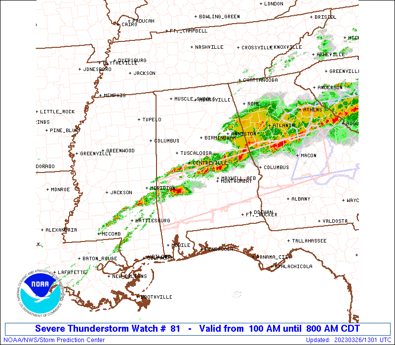
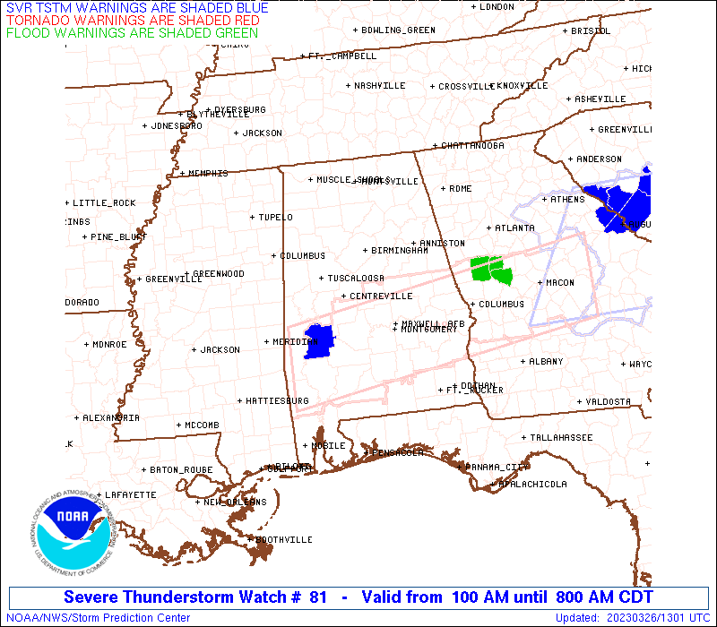
Severe Thunderstorm Watch Number 81
NWS Storm Prediction Center Norman OK
100 AM CDT Sun Mar 26 2023
The NWS Storm Prediction Center has issued a
* Severe Thunderstorm Watch for portions of
Central Alabama
* Effective this Sunday morning from 100 AM until 800 AM CDT.
* Primary threats include...
Scattered large hail and isolated very large hail events to 2.5
inches in diameter possible
Isolated damaging wind gusts to 65 mph possible
A tornado or two possible
SUMMARY...A few supercells should develop along a west-southwest to
east-northeast oriented moisture gradient this morning. Large hail
will be the primary hazard.
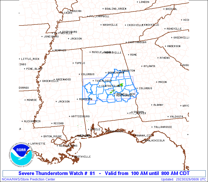
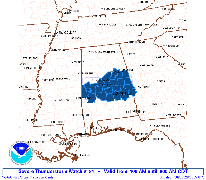
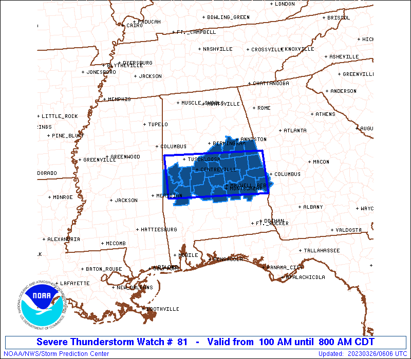
The severe thunderstorm watch area is approximately along and 40
statute miles north and south of a line from 20 miles east of Auburn
AL to 80 miles west northwest of Selma AL. For a complete depiction
of the watch see the associated watch outline update (WOUS64 KWNS
WOU1).
PRECAUTIONARY/PREPAREDNESS ACTIONS...
REMEMBER...A Severe Thunderstorm Watch means conditions are
favorable for severe thunderstorms in and close to the watch area.
Persons in these areas should be on the lookout for threatening
weather conditions and listen for later statements and possible
warnings. Severe thunderstorms can and occasionally do produce
tornadoes.
&&
AVIATION...A few severe thunderstorms with hail surface and aloft to
2.5 inches. Extreme turbulence and surface wind gusts to 55 knots. A
few cumulonimbi with maximum tops to 500. Mean storm motion vector
24035.
...Grams
 Note:
The Aviation Watch (SAW) product is an approximation to the watch area.
The actual watch is depicted by the shaded areas.
Note:
The Aviation Watch (SAW) product is an approximation to the watch area.
The actual watch is depicted by the shaded areas.
   SAW1
   WW 81 SEVERE TSTM AL 260600Z - 261300Z
   AXIS..40 STATUTE MILES NORTH AND SOUTH OF LINE..
   20E AUO/AUBURN AL/ - 80WNW SEM/SELMA AL/
   ..AVIATION COORDS.. 35NM N/S /27SSE LGC - 37NE MEI/
   HAIL SURFACE AND ALOFT..2.5 INCHES. WIND GUSTS..55 KNOTS.
   MAX TOPS TO 500. MEAN STORM MOTION VECTOR 24035.

   LAT...LON 32038509 32218825 33378825 33188509

   THIS IS AN APPROXIMATION TO THE WATCH AREA.  FOR A
   COMPLETE DEPICTION OF THE WATCH SEE WOUS64 KWNS
   FOR WOU1.
Watch 81 Status Report Messages:
STATUS REPORT #3 ON WW 81

VALID 261045Z - 261140Z

THE SEVERE WEATHER THREAT CONTINUES ACROSS THE ENTIRE WATCH AREA.

..GOSS..03/26/23

ATTN...WFO...BMX...

&&

STATUS REPORT FOR WS 81

SEVERE WEATHER THREAT CONTINUES FOR THE FOLLOWING AREAS

ALC001-007-011-017-021-027-037-047-051-063-065-081-085-087-091-
101-105-111-113-117-119-121-123-261140-

AL
.    ALABAMA COUNTIES INCLUDED ARE

AUTAUGA 	     BIBB		 BULLOCK
CHAMBERS	     CHILTON		 CLAY
COOSA		     DALLAS		 ELMORE
GREENE		     HALE		 LEE
LOWNDES 	     MACON		 MARENGO
MONTGOMERY	     PERRY		 RANDOLPH
RUSSELL 	     SHELBY		 SUMTER
TALLADEGA	     TALLAPOOSA
$$


THE WATCH STATUS MESSAGE IS FOR GUIDANCE PURPOSES ONLY.  PLEASE
REFER TO WATCH COUNTY NOTIFICATION STATEMENTS FOR OFFICIAL
INFORMATION ON COUNTIES...INDEPENDENT CITIES AND MARINE ZONES
CLEARED FROM SEVERE THUNDERSTORM AND TORNADO WATCHES.
$$

STATUS REPORT #2 ON WW 81

VALID 260935Z - 261040Z

THE SEVERE WEATHER THREAT CONTINUES ACROSS THE ENTIRE WATCH AREA.

..GOSS..03/26/23

ATTN...WFO...BMX...

&&

STATUS REPORT FOR WS 81

SEVERE WEATHER THREAT CONTINUES FOR THE FOLLOWING AREAS

ALC001-007-011-017-021-027-037-047-051-063-065-081-085-087-091-
101-105-111-113-117-119-121-123-261040-

AL
.    ALABAMA COUNTIES INCLUDED ARE

AUTAUGA 	     BIBB		 BULLOCK
CHAMBERS	     CHILTON		 CLAY
COOSA		     DALLAS		 ELMORE
GREENE		     HALE		 LEE
LOWNDES 	     MACON		 MARENGO
MONTGOMERY	     PERRY		 RANDOLPH
RUSSELL 	     SHELBY		 SUMTER
TALLADEGA	     TALLAPOOSA
$$


THE WATCH STATUS MESSAGE IS FOR GUIDANCE PURPOSES ONLY.  PLEASE
REFER TO WATCH COUNTY NOTIFICATION STATEMENTS FOR OFFICIAL
INFORMATION ON COUNTIES...INDEPENDENT CITIES AND MARINE ZONES
CLEARED FROM SEVERE THUNDERSTORM AND TORNADO WATCHES.
$$

STATUS REPORT #1 ON WW 81

VALID 260840Z - 260940Z

THE SEVERE WEATHER THREAT CONTINUES ACROSS THE ENTIRE WATCH AREA.

..GOSS..03/26/23

ATTN...WFO...BMX...

&&

STATUS REPORT FOR WS 81

SEVERE WEATHER THREAT CONTINUES FOR THE FOLLOWING AREAS

ALC001-007-011-017-021-027-037-047-051-063-065-081-085-087-091-
101-105-111-113-117-119-121-123-260940-

AL
.    ALABAMA COUNTIES INCLUDED ARE

AUTAUGA 	     BIBB		 BULLOCK
CHAMBERS	     CHILTON		 CLAY
COOSA		     DALLAS		 ELMORE
GREENE		     HALE		 LEE
LOWNDES 	     MACON		 MARENGO
MONTGOMERY	     PERRY		 RANDOLPH
RUSSELL 	     SHELBY		 SUMTER
TALLADEGA	     TALLAPOOSA
$$


THE WATCH STATUS MESSAGE IS FOR GUIDANCE PURPOSES ONLY.  PLEASE
REFER TO WATCH COUNTY NOTIFICATION STATEMENTS FOR OFFICIAL
INFORMATION ON COUNTIES...INDEPENDENT CITIES AND MARINE ZONES
CLEARED FROM SEVERE THUNDERSTORM AND TORNADO WATCHES.
$$
Note:
Click for Complete Product Text.
Tornadoes
Probability of 2 or more tornadoes
|
Low (20%)
|
Probability of 1 or more strong (EF2-EF5) tornadoes
|
Low (10%)
|
Wind
Probability of 10 or more severe wind events
|
Low (20%)
|
Probability of 1 or more wind events > 65 knots
|
Low (20%)
|
Hail
Probability of 10 or more severe hail events
|
Mod (50%)
|
Probability of 1 or more hailstones > 2 inches
|
Mod (40%)
|
Combined Severe Hail/Wind
Probability of 6 or more combined severe hail/wind events
|
High (70%)
|
For each watch, probabilities for particular events inside the watch
(listed above in each table) are determined by the issuing forecaster.
The "Low" category contains probability values ranging from less than 2%
to 20% (EF2-EF5 tornadoes), less than 5% to 20% (all other probabilities),
"Moderate" from 30% to 60%, and "High" from 70% to greater than 95%.
High values are bolded and lighter in color to provide awareness of
an increased threat for a particular event.


 @NWSSPC