 Note:
The expiration time in the watch graphic is amended if the watch is
replaced, cancelled or extended.
Note:
Note:
The expiration time in the watch graphic is amended if the watch is
replaced, cancelled or extended.
Note: Click for
Watch Status Reports.
SEL0
URGENT - IMMEDIATE BROADCAST REQUESTED
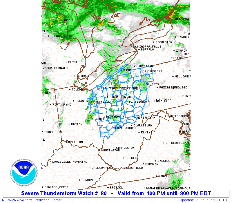
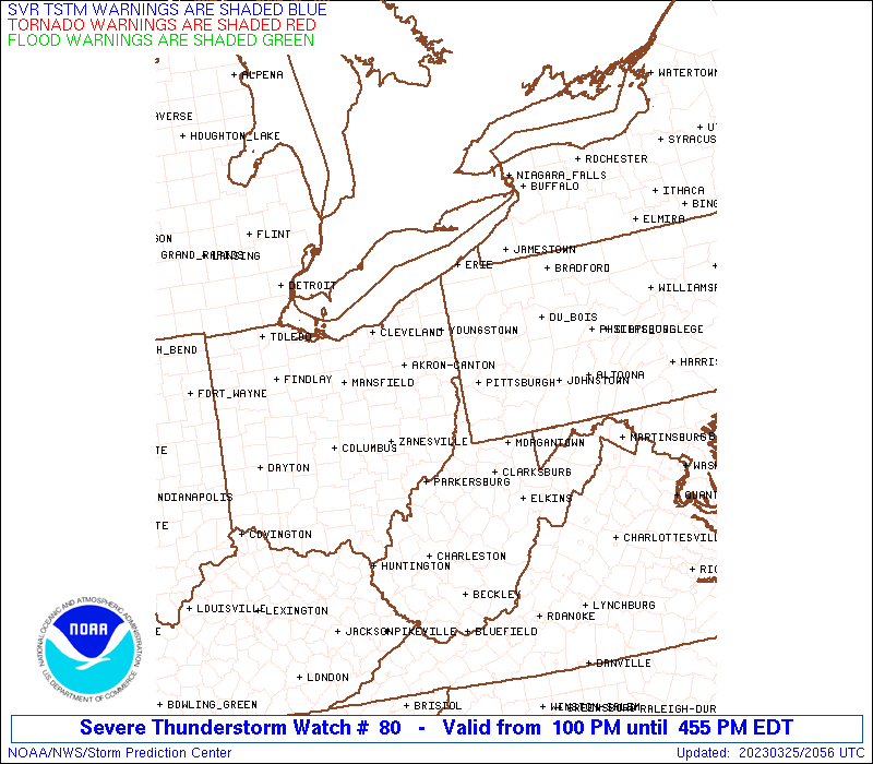
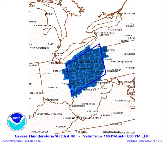
Severe Thunderstorm Watch Number 80
NWS Storm Prediction Center Norman OK
100 PM EDT Sat Mar 25 2023
The NWS Storm Prediction Center has issued a
* Severe Thunderstorm Watch for portions of
Eastern Ohio
Western Pennsylvania
Northern West Virginia including the Northern Panhandle
Lake Erie
* Effective this Saturday afternoon and evening from 100 PM until
800 PM EDT.
* Primary threats include...
Scattered damaging winds likely with isolated significant gusts
to 75 mph possible
Isolated large hail events to 1 inch in diameter possible
A tornado or two possible
SUMMARY...Fast moving showers and thunderstorms are expected to
track across eastern Ohio into western Pennsylvania this afternoon.
The strongest cells will pose a risk of damaging wind gusts and some
hail.
The severe thunderstorm watch area is approximately along and 75
statute miles north and south of a line from 25 miles northwest of
Zanesville OH to 5 miles east northeast of Dubois PA. For a complete
depiction of the watch see the associated watch outline update
(WOUS64 KWNS WOU0).
PRECAUTIONARY/PREPAREDNESS ACTIONS...
REMEMBER...A Severe Thunderstorm Watch means conditions are
favorable for severe thunderstorms in and close to the watch area.
Persons in these areas should be on the lookout for threatening
weather conditions and listen for later statements and possible
warnings. Severe thunderstorms can and occasionally do produce
tornadoes.
&&
OTHER WATCH INFORMATION...CONTINUE...WW 79...
AVIATION...A few severe thunderstorms with hail surface and aloft to
1 inch. Extreme turbulence and surface wind gusts to 65 knots. A few
cumulonimbi with maximum tops to 400. Mean storm motion vector
25040.
...Hart
 Note:
The Aviation Watch (SAW) product is an approximation to the watch area.
The actual watch is depicted by the shaded areas.
Note:
The Aviation Watch (SAW) product is an approximation to the watch area.
The actual watch is depicted by the shaded areas.
   SAW0
   WW 80 SEVERE TSTM OH PA WV LE 251700Z - 260000Z
   AXIS..75 STATUTE MILES NORTH AND SOUTH OF LINE..
   25NW ZZV/ZANESVILLE OH/ - 5ENE DUJ/DUBOIS PA/
   ..AVIATION COORDS.. 65NM N/S /17ENE APE - 41WNW PSB/
   HAIL SURFACE AND ALOFT..1 INCH. WIND GUSTS..65 KNOTS.
   MAX TOPS TO 400. MEAN STORM MOTION VECTOR 25040.

   LAT...LON 41298223 42297881 40127881 39128223

   THIS IS AN APPROXIMATION TO THE WATCH AREA.  FOR A
   COMPLETE DEPICTION OF THE WATCH SEE WOUS64 KWNS
   FOR WOU0.
Watch 80 Status Report Messages:
STATUS REPORT #4 ON WW 80

VALID 252030Z - 252140Z

SEVERE WEATHER THREAT CONTINUES RIGHT OF A LINE FROM 25 E MGW TO
20 NE ERI.

..MOORE..03/25/23

ATTN...WFO...CLE...RLX...PBZ...CTP...

&&

STATUS REPORT FOR WS 80

SEVERE WEATHER THREAT CONTINUES FOR THE FOLLOWING AREAS

PAC005-031-047-053-063-065-083-123-129-252140-

PA
.    PENNSYLVANIA COUNTIES INCLUDED ARE

ARMSTRONG	     CLARION		 ELK
FOREST		     INDIANA		 JEFFERSON
MCKEAN		     WARREN		 WESTMORELAND
$$


THE WATCH STATUS MESSAGE IS FOR GUIDANCE PURPOSES ONLY.  PLEASE
REFER TO WATCH COUNTY NOTIFICATION STATEMENTS FOR OFFICIAL
INFORMATION ON COUNTIES...INDEPENDENT CITIES AND MARINE ZONES
CLEARED FROM SEVERE THUNDERSTORM AND TORNADO WATCHES.
$$

STATUS REPORT #3 ON WW 80

VALID 251940Z - 252040Z

SEVERE WEATHER THREAT CONTINUES RIGHT OF A LINE FROM 30 ESE PKB
TO 30 W ERI.

FOR ADDITIONAL INFORMATION SEE MESOSCALE DISCUSSION 342

..MOORE..03/25/23

ATTN...WFO...CLE...RLX...PBZ...CTP...

&&

STATUS REPORT FOR WS 80

SEVERE WEATHER THREAT CONTINUES FOR THE FOLLOWING AREAS

OHC007-029-081-099-155-252040-

OH
.    OHIO COUNTIES INCLUDED ARE

ASHTABULA	     COLUMBIANA 	 JEFFERSON
MAHONING	     TRUMBULL
$$


PAC003-005-007-019-031-039-047-049-051-053-059-063-065-073-083-
085-121-123-125-129-252040-

PA
.    PENNSYLVANIA COUNTIES INCLUDED ARE

ALLEGHENY	     ARMSTRONG		 BEAVER
BUTLER		     CLARION		 CRAWFORD
ELK		     ERIE		 FAYETTE
FOREST		     GREENE		 INDIANA
JEFFERSON	     LAWRENCE		 MCKEAN
MERCER		     VENANGO		 WARREN
WASHINGTON	     WESTMORELAND
$$


WVC009-029-049-051-061-069-103-252040-

WV
.    WEST VIRGINIA COUNTIES INCLUDED ARE

BROOKE		     HANCOCK		 MARION
MARSHALL	     MONONGALIA 	 OHIO
WETZEL
$$


LEZ148-149-252040-

CW

.    ADJACENT COASTAL WATERS INCLUDED ARE

GENEVA-ON-THE-LAKE TO CONNEAUT OH

CONNEAUT OH TO RIPLEY NY

$$
THE WATCH STATUS MESSAGE IS FOR GUIDANCE PURPOSES ONLY.  PLEASE
REFER TO WATCH COUNTY NOTIFICATION STATEMENTS FOR OFFICIAL
INFORMATION ON COUNTIES...INDEPENDENT CITIES AND MARINE ZONES
CLEARED FROM SEVERE THUNDERSTORM AND TORNADO WATCHES.
$$

STATUS REPORT #2 ON WW 80

VALID 251850Z - 251940Z

SEVERE WEATHER THREAT CONTINUES RIGHT OF A LINE FROM 20 E CMH TO
40 NNE CLE.

FOR ADDITIONAL INFORMATION SEE MESOSCALE DISCUSSION 342

..MOORE..03/25/23

ATTN...WFO...CLE...RLX...PBZ...CTP...

&&

STATUS REPORT FOR WS 80

SEVERE WEATHER THREAT CONTINUES FOR THE FOLLOWING AREAS

OHC007-009-013-019-029-031-035-055-059-067-075-081-085-099-103-
105-111-115-119-121-127-133-151-153-155-157-167-169-251940-

OH
.    OHIO COUNTIES INCLUDED ARE

ASHTABULA	     ATHENS		 BELMONT
CARROLL 	     COLUMBIANA 	 COSHOCTON
CUYAHOGA	     GEAUGA		 GUERNSEY
HARRISON	     HOLMES		 JEFFERSON
LAKE		     MAHONING		 MEDINA
MEIGS		     MONROE		 MORGAN
MUSKINGUM	     NOBLE		 PERRY
PORTAGE 	     STARK		 SUMMIT
TRUMBULL	     TUSCARAWAS 	 WASHINGTON
WAYNE
$$


PAC003-005-007-019-031-039-047-049-051-053-059-063-065-073-083-
085-121-123-125-129-251940-

PA
.    PENNSYLVANIA COUNTIES INCLUDED ARE

ALLEGHENY	     ARMSTRONG		 BEAVER
BUTLER		     CLARION		 CRAWFORD
ELK		     ERIE		 FAYETTE
FOREST		     GREENE		 INDIANA
JEFFERSON	     LAWRENCE		 MCKEAN
MERCER		     VENANGO		 WARREN
WASHINGTON	     WESTMORELAND
$$


WVC009-029-049-051-061-069-073-095-103-107-251940-

WV
.    WEST VIRGINIA COUNTIES INCLUDED ARE

BROOKE		     HANCOCK		 MARION
MARSHALL	     MONONGALIA 	 OHIO
PLEASANTS	     TYLER		 WETZEL
WOOD
$$


LEZ146-147-148-149-251940-

CW

.    ADJACENT COASTAL WATERS INCLUDED ARE

AVON POINT TO WILLOWICK OH

WILLOWICK TO GENEVA-ON-THE LAKE OH

GENEVA-ON-THE-LAKE TO CONNEAUT OH

CONNEAUT OH TO RIPLEY NY

$$
THE WATCH STATUS MESSAGE IS FOR GUIDANCE PURPOSES ONLY.  PLEASE
REFER TO WATCH COUNTY NOTIFICATION STATEMENTS FOR OFFICIAL
INFORMATION ON COUNTIES...INDEPENDENT CITIES AND MARINE ZONES
CLEARED FROM SEVERE THUNDERSTORM AND TORNADO WATCHES.
$$

STATUS REPORT #1 ON WW 80

VALID 251740Z - 251840Z

THE SEVERE WEATHER THREAT CONTINUES ACROSS THE ENTIRE WATCH AREA.

..MOORE..03/25/23

ATTN...WFO...CLE...RLX...PBZ...CTP...

&&

STATUS REPORT FOR WS 80

SEVERE WEATHER THREAT CONTINUES FOR THE FOLLOWING AREAS

OHC005-007-009-013-019-029-031-035-055-059-067-075-081-083-085-
093-099-103-105-111-115-119-121-127-133-139-151-153-155-157-167-
169-251840-

OH
.    OHIO COUNTIES INCLUDED ARE

ASHLAND 	     ASHTABULA		 ATHENS
BELMONT 	     CARROLL		 COLUMBIANA
COSHOCTON	     CUYAHOGA		 GEAUGA
GUERNSEY	     HARRISON		 HOLMES
JEFFERSON	     KNOX		 LAKE
LORAIN		     MAHONING		 MEDINA
MEIGS		     MONROE		 MORGAN
MUSKINGUM	     NOBLE		 PERRY
PORTAGE 	     RICHLAND		 STARK
SUMMIT		     TRUMBULL		 TUSCARAWAS
WASHINGTON	     WAYNE
$$


PAC003-005-007-019-031-039-047-049-051-053-059-063-065-073-083-
085-121-123-125-129-251840-

PA
.    PENNSYLVANIA COUNTIES INCLUDED ARE

ALLEGHENY	     ARMSTRONG		 BEAVER
BUTLER		     CLARION		 CRAWFORD
ELK		     ERIE		 FAYETTE
FOREST		     GREENE		 INDIANA
JEFFERSON	     LAWRENCE		 MCKEAN
MERCER		     VENANGO		 WARREN
WASHINGTON	     WESTMORELAND
$$


WVC009-029-049-051-061-069-073-095-103-107-251840-

WV
.    WEST VIRGINIA COUNTIES INCLUDED ARE

BROOKE		     HANCOCK		 MARION
MARSHALL	     MONONGALIA 	 OHIO
PLEASANTS	     TYLER		 WETZEL
WOOD
$$


LEZ146-147-148-149-251840-

CW

.    ADJACENT COASTAL WATERS INCLUDED ARE

AVON POINT TO WILLOWICK OH

WILLOWICK TO GENEVA-ON-THE LAKE OH

GENEVA-ON-THE-LAKE TO CONNEAUT OH

CONNEAUT OH TO RIPLEY NY

$$
THE WATCH STATUS MESSAGE IS FOR GUIDANCE PURPOSES ONLY.  PLEASE
REFER TO WATCH COUNTY NOTIFICATION STATEMENTS FOR OFFICIAL
INFORMATION ON COUNTIES...INDEPENDENT CITIES AND MARINE ZONES
CLEARED FROM SEVERE THUNDERSTORM AND TORNADO WATCHES.
$$
Note:
Click for Complete Product Text.
Tornadoes
Probability of 2 or more tornadoes
|
Low (20%)
|
Probability of 1 or more strong (EF2-EF5) tornadoes
|
Low (<2%)
|
Wind
Probability of 10 or more severe wind events
|
Mod (60%)
|
Probability of 1 or more wind events > 65 knots
|
Mod (30%)
|
Hail
Probability of 10 or more severe hail events
|
Low (20%)
|
Probability of 1 or more hailstones > 2 inches
|
Low (10%)
|
Combined Severe Hail/Wind
Probability of 6 or more combined severe hail/wind events
|
High (80%)
|
For each watch, probabilities for particular events inside the watch
(listed above in each table) are determined by the issuing forecaster.
The "Low" category contains probability values ranging from less than 2%
to 20% (EF2-EF5 tornadoes), less than 5% to 20% (all other probabilities),
"Moderate" from 30% to 60%, and "High" from 70% to greater than 95%.
High values are bolded and lighter in color to provide awareness of
an increased threat for a particular event.


 @NWSSPC