 Note:
The expiration time in the watch graphic is amended if the watch is
replaced, cancelled or extended.
Note:
Note:
The expiration time in the watch graphic is amended if the watch is
replaced, cancelled or extended.
Note: Click for
Watch Status Reports.
SEL2
URGENT - IMMEDIATE BROADCAST REQUESTED
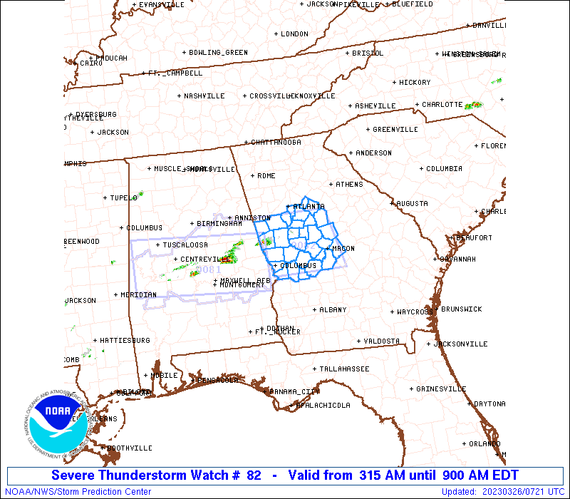
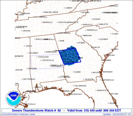
Severe Thunderstorm Watch Number 82
NWS Storm Prediction Center Norman OK
315 AM EDT Sun Mar 26 2023
The NWS Storm Prediction Center has issued a
* Severe Thunderstorm Watch for portions of
West-central Georgia
* Effective this Sunday morning from 315 AM until 900 AM EDT.
* Primary threats include...
Scattered large hail and isolated very large hail events to 2
inches in diameter possible
Isolated damaging wind gusts to 65 mph possible
A tornado or two possible
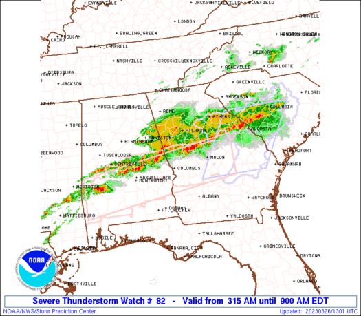
SUMMARY...A couple supercells should spread east into west-central
Georgia during the next few hours. Additional storms may develop
later this morning as well. Large hail should be the primary hazard.
The severe thunderstorm watch area is approximately along and 50
statute miles east and west of a line from 50 miles northeast of La
Grange GA to 40 miles southwest of Macon GA. For a complete
depiction of the watch see the associated watch outline update
(WOUS64 KWNS WOU2).
PRECAUTIONARY/PREPAREDNESS ACTIONS...
REMEMBER...A Severe Thunderstorm Watch means conditions are
favorable for severe thunderstorms in and close to the watch area.
Persons in these areas should be on the lookout for threatening
weather conditions and listen for later statements and possible
warnings. Severe thunderstorms can and occasionally do produce
tornadoes.
&&
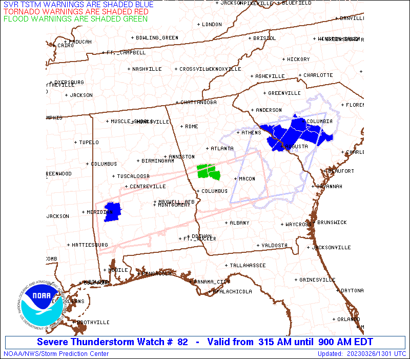
OTHER WATCH INFORMATION...CONTINUE...WW 81...
AVIATION...A few severe thunderstorms with hail surface and aloft to
2 inches. Extreme turbulence and surface wind gusts to 55 knots. A
few cumulonimbi with maximum tops to 450. Mean storm motion vector
25035.
...Grams
 Note:
The Aviation Watch (SAW) product is an approximation to the watch area.
The actual watch is depicted by the shaded areas.
Note:
The Aviation Watch (SAW) product is an approximation to the watch area.
The actual watch is depicted by the shaded areas.
   SAW2
   WW 82 SEVERE TSTM GA 260715Z - 261300Z
   AXIS..50 STATUTE MILES EAST AND WEST OF LINE..
   50NE LGC/LA GRANGE GA/ - 40SW MCN/MACON GA/
   ..AVIATION COORDS.. 45NM E/W /7S ATL - 34SW MCN/
   HAIL SURFACE AND ALOFT..2 INCHES. WIND GUSTS..55 KNOTS.
   MAX TOPS TO 450. MEAN STORM MOTION VECTOR 25035.

   LAT...LON 33508359 32298328 32298499 33508532

   THIS IS AN APPROXIMATION TO THE WATCH AREA.  FOR A
   COMPLETE DEPICTION OF THE WATCH SEE WOUS64 KWNS
   FOR WOU2.
Watch 82 Status Report Messages:
STATUS REPORT #3 ON WW 82

VALID 261045Z - 261140Z

THE SEVERE WEATHER THREAT CONTINUES ACROSS THE ENTIRE WATCH AREA.

..GOSS..03/26/23

ATTN...WFO...FFC...

&&

STATUS REPORT FOR WS 82

SEVERE WEATHER THREAT CONTINUES FOR THE FOLLOWING AREAS

GAC021-035-053-063-077-079-113-145-149-151-153-159-169-171-193-
197-199-207-215-217-225-231-247-249-255-263-269-285-289-293-
261140-

GA
.    GEORGIA COUNTIES INCLUDED ARE

BIBB		     BUTTS		 CHATTAHOOCHEE
CLAYTON 	     COWETA		 CRAWFORD
FAYETTE 	     HARRIS		 HEARD
HENRY		     HOUSTON		 JASPER
JONES		     LAMAR		 MACON
MARION		     MERIWETHER 	 MONROE
MUSCOGEE	     NEWTON		 PEACH
PIKE		     ROCKDALE		 SCHLEY
SPALDING	     TALBOT		 TAYLOR
TROUP		     TWIGGS		 UPSON
$$


THE WATCH STATUS MESSAGE IS FOR GUIDANCE PURPOSES ONLY.  PLEASE
REFER TO WATCH COUNTY NOTIFICATION STATEMENTS FOR OFFICIAL
INFORMATION ON COUNTIES...INDEPENDENT CITIES AND MARINE ZONES
CLEARED FROM SEVERE THUNDERSTORM AND TORNADO WATCHES.
$$

STATUS REPORT #2 ON WW 82

VALID 260935Z - 261040Z

THE SEVERE WEATHER THREAT CONTINUES ACROSS THE ENTIRE WATCH AREA.

..GOSS..03/26/23

ATTN...WFO...FFC...

&&

STATUS REPORT FOR WS 82

SEVERE WEATHER THREAT CONTINUES FOR THE FOLLOWING AREAS

GAC021-035-053-063-077-079-113-145-149-151-153-159-169-171-193-
197-199-207-215-217-225-231-247-249-255-263-269-285-289-293-
261040-

GA
.    GEORGIA COUNTIES INCLUDED ARE

BIBB		     BUTTS		 CHATTAHOOCHEE
CLAYTON 	     COWETA		 CRAWFORD
FAYETTE 	     HARRIS		 HEARD
HENRY		     HOUSTON		 JASPER
JONES		     LAMAR		 MACON
MARION		     MERIWETHER 	 MONROE
MUSCOGEE	     NEWTON		 PEACH
PIKE		     ROCKDALE		 SCHLEY
SPALDING	     TALBOT		 TAYLOR
TROUP		     TWIGGS		 UPSON
$$


THE WATCH STATUS MESSAGE IS FOR GUIDANCE PURPOSES ONLY.  PLEASE
REFER TO WATCH COUNTY NOTIFICATION STATEMENTS FOR OFFICIAL
INFORMATION ON COUNTIES...INDEPENDENT CITIES AND MARINE ZONES
CLEARED FROM SEVERE THUNDERSTORM AND TORNADO WATCHES.
$$

STATUS REPORT #1 ON WW 82

VALID 260840Z - 260940Z

THE SEVERE WEATHER THREAT CONTINUES ACROSS THE ENTIRE WATCH AREA.

..GOSS..03/26/23

ATTN...WFO...FFC...

&&

STATUS REPORT FOR WS 82

SEVERE WEATHER THREAT CONTINUES FOR THE FOLLOWING AREAS

GAC021-035-053-063-077-079-113-145-149-151-153-159-169-171-193-
197-199-207-215-217-225-231-247-249-255-263-269-285-289-293-
260940-

GA
.    GEORGIA COUNTIES INCLUDED ARE

BIBB		     BUTTS		 CHATTAHOOCHEE
CLAYTON 	     COWETA		 CRAWFORD
FAYETTE 	     HARRIS		 HEARD
HENRY		     HOUSTON		 JASPER
JONES		     LAMAR		 MACON
MARION		     MERIWETHER 	 MONROE
MUSCOGEE	     NEWTON		 PEACH
PIKE		     ROCKDALE		 SCHLEY
SPALDING	     TALBOT		 TAYLOR
TROUP		     TWIGGS		 UPSON
$$


THE WATCH STATUS MESSAGE IS FOR GUIDANCE PURPOSES ONLY.  PLEASE
REFER TO WATCH COUNTY NOTIFICATION STATEMENTS FOR OFFICIAL
INFORMATION ON COUNTIES...INDEPENDENT CITIES AND MARINE ZONES
CLEARED FROM SEVERE THUNDERSTORM AND TORNADO WATCHES.
$$
Note:
Click for Complete Product Text.
Tornadoes
Probability of 2 or more tornadoes
|
Low (20%)
|
Probability of 1 or more strong (EF2-EF5) tornadoes
|
Low (10%)
|
Wind
Probability of 10 or more severe wind events
|
Low (20%)
|
Probability of 1 or more wind events > 65 knots
|
Low (20%)
|
Hail
Probability of 10 or more severe hail events
|
Mod (40%)
|
Probability of 1 or more hailstones > 2 inches
|
Mod (30%)
|
Combined Severe Hail/Wind
Probability of 6 or more combined severe hail/wind events
|
Mod (60%)
|
For each watch, probabilities for particular events inside the watch
(listed above in each table) are determined by the issuing forecaster.
The "Low" category contains probability values ranging from less than 2%
to 20% (EF2-EF5 tornadoes), less than 5% to 20% (all other probabilities),
"Moderate" from 30% to 60%, and "High" from 70% to greater than 95%.
High values are bolded and lighter in color to provide awareness of
an increased threat for a particular event.


 @NWSSPC