Note:
The expiration time in the watch graphic is amended if the watch is
replaced, cancelled or extended.
Note:
Note:
The expiration time in the watch graphic is amended if the watch is
replaced, cancelled or extended.
Note: Click for
Watch Status Reports.
SEL8
URGENT - IMMEDIATE BROADCAST REQUESTED
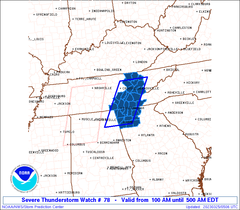
Severe Thunderstorm Watch Number 78
NWS Storm Prediction Center Norman OK
100 AM EDT Sat Mar 25 2023
The NWS Storm Prediction Center has issued a
* Severe Thunderstorm Watch for portions of
Northwest Georgia
Extreme western North Carolina
Eastern Tennessee
* Effective this Saturday morning from 100 AM until 500 AM EDT.
* Primary threats include...
Scattered damaging wind gusts to 70 mph possible
A tornado or two possible
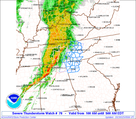
SUMMARY...A squall line with embedded bowing segments will move
eastward overnight, and reach eastern Tennessee and northwest
Georgia. The primary threat with these storms will be damaging
gusts, though a tornado or two will be possible with embedded
circulations.
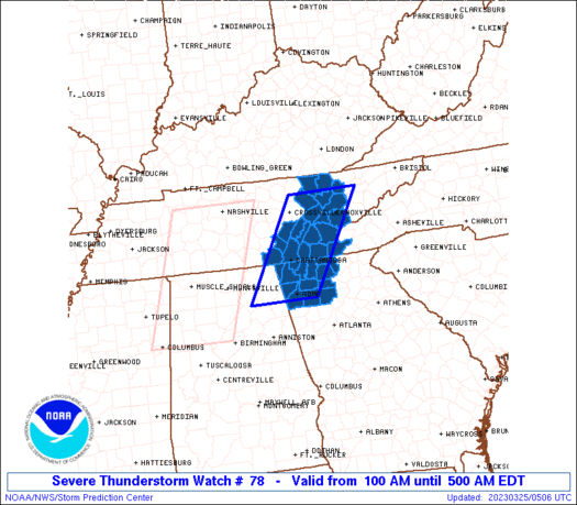
The severe thunderstorm watch area is approximately along and 45
statute miles east and west of a line from 35 miles north northwest
of Knoxville TN to 20 miles west southwest of Rome GA. For a
complete depiction of the watch see the associated watch outline
update (WOUS64 KWNS WOU8).
PRECAUTIONARY/PREPAREDNESS ACTIONS...
REMEMBER...A Severe Thunderstorm Watch means conditions are
favorable for severe thunderstorms in and close to the watch area.
Persons in these areas should be on the lookout for threatening
weather conditions and listen for later statements and possible
warnings. Severe thunderstorms can and occasionally do produce
tornadoes.
&&
OTHER WATCH INFORMATION...CONTINUE...WW 76...WW 77...
AVIATION...A few severe thunderstorms with hail surface and aloft to
0.5 inches. Extreme turbulence and surface wind gusts to 60 knots. A
few cumulonimbi with maximum tops to 400. Mean storm motion vector
25055.
...Thompson
   SEL8

   URGENT - IMMEDIATE BROADCAST REQUESTED
   Severe Thunderstorm Watch Number 78
   NWS Storm Prediction Center Norman OK
   100 AM EDT Sat Mar 25 2023

   The NWS Storm Prediction Center has issued a

   * Severe Thunderstorm Watch for portions of
     Northwest Georgia
     Extreme western North Carolina
     Eastern Tennessee

   * Effective this Saturday morning from 100 AM until 500 AM EDT.

   * Primary threats include...
     Scattered damaging wind gusts to 70 mph possible
     A tornado or two possible

   SUMMARY...A squall line with embedded bowing segments will move
   eastward overnight, and reach eastern Tennessee and northwest
   Georgia.  The primary threat with these storms will be damaging
   gusts, though a tornado or two will be possible with embedded
   circulations.

   The severe thunderstorm watch area is approximately along and 45
   statute miles east and west of a line from 35 miles north northwest
   of Knoxville TN to 20 miles west southwest of Rome GA. For a
   complete depiction of the watch see the associated watch outline
   update (WOUS64 KWNS WOU8).

   PRECAUTIONARY/PREPAREDNESS ACTIONS...

   REMEMBER...A Severe Thunderstorm Watch means conditions are
   favorable for severe thunderstorms in and close to the watch area.
   Persons in these areas should be on the lookout for threatening
   weather conditions and listen for later statements and possible
   warnings. Severe thunderstorms can and occasionally do produce
   tornadoes.

   &&

   OTHER WATCH INFORMATION...CONTINUE...WW 76...WW 77...

   AVIATION...A few severe thunderstorms with hail surface and aloft to
   0.5 inches. Extreme turbulence and surface wind gusts to 60 knots. A
   few cumulonimbi with maximum tops to 400. Mean storm motion vector
   25055.

   ...Thompson
 Note:
The Aviation Watch (SAW) product is an approximation to the watch area.
The actual watch is depicted by the shaded areas.
Note:
The Aviation Watch (SAW) product is an approximation to the watch area.
The actual watch is depicted by the shaded areas.
   SAW8
   WW 78 SEVERE TSTM GA NC TN 250500Z - 250900Z
   AXIS..45 STATUTE MILES EAST AND WEST OF LINE..
   35NNW TYS/KNOXVILLE TN/ - 20WSW RMG/ROME GA/
   ..AVIATION COORDS.. 40NM E/W /29NW VXV - 47SSW GQO/
   HAIL SURFACE AND ALOFT..0.5 INCH. WIND GUSTS..60 KNOTS.
   MAX TOPS TO 400. MEAN STORM MOTION VECTOR 25055.

   LAT...LON 36298343 34248471 34248628 36298505

   THIS IS AN APPROXIMATION TO THE WATCH AREA.  FOR A
   COMPLETE DEPICTION OF THE WATCH SEE WOUS64 KWNS
   FOR WOU8.
Watch 78 Status Report Messages:
STATUS REPORT #1 ON WW 78

VALID 250740Z - 250840Z

SEVERE WEATHER THREAT CONTINUES RIGHT OF A LINE FROM 25 NNW GAD
TO 30 WNW RMG TO 25 ENE CHA TO 35 N TYS.

..GOSS..03/25/23

ATTN...WFO...FFC...MRX...

&&

STATUS REPORT FOR WS 78

SEVERE WEATHER THREAT CONTINUES FOR THE FOLLOWING AREAS

GAC015-055-057-111-115-123-129-213-227-295-313-250840-

GA
.    GEORGIA COUNTIES INCLUDED ARE

BARTOW		     CHATTOOGA		 CHEROKEE
FANNIN		     FLOYD		 GILMER
GORDON		     MURRAY		 PICKENS
WALKER		     WHITFIELD
$$


NCC039-250840-

NC
.    NORTH CAROLINA COUNTIES INCLUDED ARE

CHEROKEE
$$


TNC009-093-105-107-123-139-173-250840-

TN
.    TENNESSEE COUNTIES INCLUDED ARE

BLOUNT		     KNOX		 LOUDON
MCMINN		     MONROE		 POLK
UNION
$$


THE WATCH STATUS MESSAGE IS FOR GUIDANCE PURPOSES ONLY.  PLEASE
REFER TO WATCH COUNTY NOTIFICATION STATEMENTS FOR OFFICIAL
INFORMATION ON COUNTIES...INDEPENDENT CITIES AND MARINE ZONES
CLEARED FROM SEVERE THUNDERSTORM AND TORNADO WATCHES.
$$
Note:
Click for Complete Product Text.
Tornadoes
Probability of 2 or more tornadoes
|
Low (20%)
|
Probability of 1 or more strong (EF2-EF5) tornadoes
|
Low (5%)
|
Wind
Probability of 10 or more severe wind events
|
Mod (40%)
|
Probability of 1 or more wind events > 65 knots
|
Low (20%)
|
Hail
Probability of 10 or more severe hail events
|
Low (10%)
|
Probability of 1 or more hailstones > 2 inches
|
Low (<5%)
|
Combined Severe Hail/Wind
Probability of 6 or more combined severe hail/wind events
|
Mod (60%)
|
For each watch, probabilities for particular events inside the watch
(listed above in each table) are determined by the issuing forecaster.
The "Low" category contains probability values ranging from less than 2%
to 20% (EF2-EF5 tornadoes), less than 5% to 20% (all other probabilities),
"Moderate" from 30% to 60%, and "High" from 70% to greater than 95%.
High values are bolded and lighter in color to provide awareness of
an increased threat for a particular event.


 @NWSSPC