 Note:
The expiration time in the watch graphic is amended if the watch is
replaced, cancelled or extended.
Note:
Note:
The expiration time in the watch graphic is amended if the watch is
replaced, cancelled or extended.
Note: Click for
Watch Status Reports.
SEL7
URGENT - IMMEDIATE BROADCAST REQUESTED
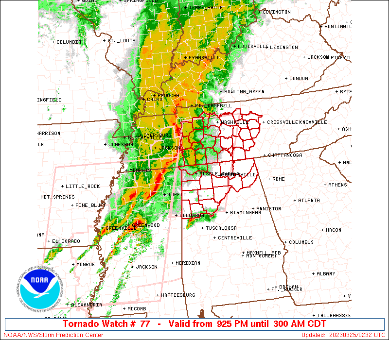
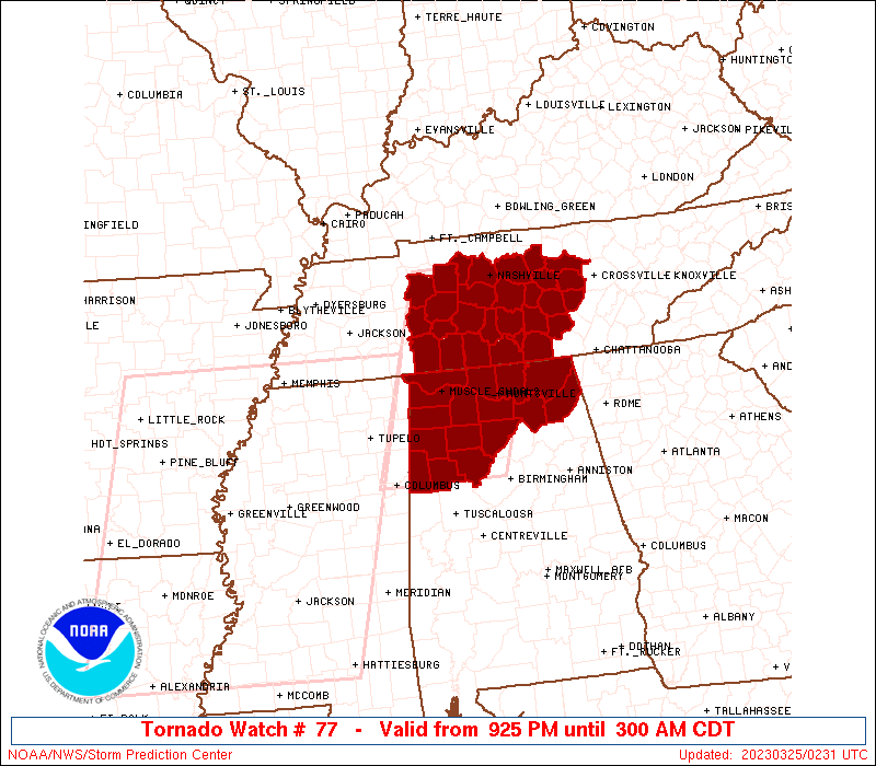
Tornado Watch Number 77
NWS Storm Prediction Center Norman OK
925 PM CDT Fri Mar 24 2023
The NWS Storm Prediction Center has issued a
* Tornado Watch for portions of
Northern Alabama
Middle Tennessee
* Effective this Friday night and Saturday morning from 925 PM
until 300 AM CDT.
* Primary threats include...
A few tornadoes likely with a couple intense tornadoes possible
Scattered damaging winds likely with isolated significant gusts
to 75 mph possible
Isolated large hail events to 1 inch in diameter possible
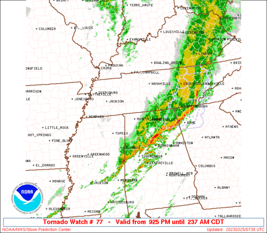
SUMMARY...A bowing squall line will continue eastward from northeast
Mississippi and western Tennessee into middle Tennessee and
northwestern Alabama through the early overnight hours. The squall
line will pose a threat for embedded tornadoes and swaths of
damaging winds up to 75 mph. Farther south, a supercell or two may
persist into Alabama ahead of the squall line, with the potential to
produce a strong tornado or two.
The tornado watch area is approximately along and 55 statute miles
east and west of a line from 15 miles northwest of Nashville TN to
40 miles east of Columbus MS. For a complete depiction of the watch
see the associated watch outline update (WOUS64 KWNS WOU7).
PRECAUTIONARY/PREPAREDNESS ACTIONS...
REMEMBER...A Tornado Watch means conditions are favorable for
tornadoes and severe thunderstorms in and close to the watch
area. Persons in these areas should be on the lookout for
threatening weather conditions and listen for later statements
and possible warnings.
&&
OTHER WATCH INFORMATION...CONTINUE...WW 76...
AVIATION...Tornadoes and a few severe thunderstorms with hail
surface and aloft to 1 inch. Extreme turbulence and surface wind
gusts to 65 knots. A few cumulonimbi with maximum tops to 450. Mean
storm motion vector 25050.
...Thompson

   SEL7

   URGENT - IMMEDIATE BROADCAST REQUESTED
   Tornado Watch Number 77
   NWS Storm Prediction Center Norman OK
   925 PM CDT Fri Mar 24 2023

   The NWS Storm Prediction Center has issued a

   * Tornado Watch for portions of
     Northern Alabama
     Middle Tennessee

   * Effective this Friday night and Saturday morning from 925 PM
     until 300 AM CDT.

   * Primary threats include...
     A few tornadoes likely with a couple intense tornadoes possible
     Scattered damaging winds likely with isolated significant gusts
       to 75 mph possible
     Isolated large hail events to 1 inch in diameter possible

   SUMMARY...A bowing squall line will continue eastward from northeast
   Mississippi and western Tennessee into middle Tennessee and
   northwestern Alabama through the early overnight hours.  The squall
   line will pose a threat for embedded tornadoes and swaths of
   damaging winds up to 75 mph.  Farther south, a supercell or two may
   persist into Alabama ahead of the squall line, with the potential to
   produce a strong tornado or two.

   The tornado watch area is approximately along and 55 statute miles
   east and west of a line from 15 miles northwest of Nashville TN to
   40 miles east of Columbus MS. For a complete depiction of the watch
   see the associated watch outline update (WOUS64 KWNS WOU7).

   PRECAUTIONARY/PREPAREDNESS ACTIONS...

   REMEMBER...A Tornado Watch means conditions are favorable for
   tornadoes and severe thunderstorms in and close to the watch
   area. Persons in these areas should be on the lookout for
   threatening weather conditions and listen for later statements
   and possible warnings.

   &&

   OTHER WATCH INFORMATION...CONTINUE...WW 76...

   AVIATION...Tornadoes and a few severe thunderstorms with hail
   surface and aloft to 1 inch. Extreme turbulence and surface wind
   gusts to 65 knots. A few cumulonimbi with maximum tops to 450. Mean
   storm motion vector 25050.

   ...Thompson
 Note:
The Aviation Watch (SAW) product is an approximation to the watch area.
The actual watch is depicted by the shaded areas.
Note:
The Aviation Watch (SAW) product is an approximation to the watch area.
The actual watch is depicted by the shaded areas.
   SAW7
   WW 77 TORNADO AL TN 250225Z - 250800Z
   AXIS..55 STATUTE MILES EAST AND WEST OF LINE..
   15NW BNA/NASHVILLE TN/ - 40E CBM/COLUMBUS MS/
   ..AVIATION COORDS.. 50NM E/W /13NW BNA - 39ENE IGB/
   HAIL SURFACE AND ALOFT..1 INCH. WIND GUSTS..65 KNOTS.
   MAX TOPS TO 450. MEAN STORM MOTION VECTOR 25050.

   LAT...LON 36288588 33628680 33628871 36288786

   THIS IS AN APPROXIMATION TO THE WATCH AREA.  FOR A
   COMPLETE DEPICTION OF THE WATCH SEE WOUS64 KWNS
   FOR WOU7.
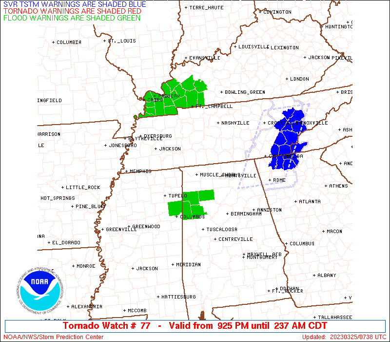
Watch 77 Status Report Messages:
STATUS REPORT #2 ON WW 77

VALID 250440Z - 250540Z

SEVERE WEATHER THREAT CONTINUES RIGHT OF A LINE FROM 5 W CBM TO
15 NE MSL TO 30 SSW BNA TO 10 NNE BNA.

..KERR..03/25/23

ATTN...WFO...HUN...BMX...OHX...

&&

STATUS REPORT FOR WT 77

SEVERE WEATHER THREAT CONTINUES FOR THE FOLLOWING AREAS

ALC043-049-057-059-071-075-079-083-089-093-095-103-127-133-
250540-

AL
.    ALABAMA COUNTIES INCLUDED ARE

CULLMAN 	     DEKALB		 FAYETTE
FRANKLIN	     JACKSON		 LAMAR
LAWRENCE	     LIMESTONE		 MADISON
MARION		     MARSHALL		 MORGAN
WALKER		     WINSTON
$$


TNC003-015-031-041-051-055-061-103-117-127-141-149-159-175-177-
185-189-250540-

TN
.    TENNESSEE COUNTIES INCLUDED ARE

BEDFORD 	     CANNON		 COFFEE
DE KALB 	     FRANKLIN		 GILES
GRUNDY		     LINCOLN		 MARSHALL
MOORE		     PUTNAM		 RUTHERFORD
SMITH		     VAN BUREN		 WARREN
WHITE		     WILSON
$$


THE WATCH STATUS MESSAGE IS FOR GUIDANCE PURPOSES ONLY.  PLEASE
REFER TO WATCH COUNTY NOTIFICATION STATEMENTS FOR OFFICIAL
INFORMATION ON COUNTIES...INDEPENDENT CITIES AND MARINE ZONES
CLEARED FROM SEVERE THUNDERSTORM AND TORNADO WATCHES.
$$

STATUS REPORT #1 ON WW 77

VALID 250320Z - 250440Z

THE SEVERE WEATHER THREAT CONTINUES ACROSS THE ENTIRE WATCH AREA.

..KERR..03/25/23

ATTN...WFO...HUN...BMX...OHX...

&&

STATUS REPORT FOR WT 77

SEVERE WEATHER THREAT CONTINUES FOR THE FOLLOWING AREAS

ALC033-043-049-057-059-071-075-077-079-083-089-093-095-103-127-
133-250440-

AL
.    ALABAMA COUNTIES INCLUDED ARE

COLBERT 	     CULLMAN		 DEKALB
FAYETTE 	     FRANKLIN		 JACKSON
LAMAR		     LAUDERDALE 	 LAWRENCE
LIMESTONE	     MADISON		 MARION
MARSHALL	     MORGAN		 WALKER
WINSTON
$$


TNC003-015-021-031-037-041-043-051-055-061-081-085-099-101-103-
117-119-127-135-141-149-159-175-177-181-185-187-189-250440-

TN
.    TENNESSEE COUNTIES INCLUDED ARE

BEDFORD 	     CANNON		 CHEATHAM
COFFEE		     DAVIDSON		 DE KALB
DICKSON 	     FRANKLIN		 GILES
GRUNDY		     HICKMAN		 HUMPHREYS
LAWRENCE	     LEWIS		 LINCOLN
MARSHALL	     MAURY		 MOORE
PERRY		     PUTNAM		 RUTHERFORD
SMITH		     VAN BUREN		 WARREN
WAYNE		     WHITE		 WILLIAMSON
WILSON
$$


THE WATCH STATUS MESSAGE IS FOR GUIDANCE PURPOSES ONLY.  PLEASE
REFER TO WATCH COUNTY NOTIFICATION STATEMENTS FOR OFFICIAL
INFORMATION ON COUNTIES...INDEPENDENT CITIES AND MARINE ZONES
CLEARED FROM SEVERE THUNDERSTORM AND TORNADO WATCHES.
$$
Note:
Click for Complete Product Text.
Tornadoes
Probability of 2 or more tornadoes
|
High (70%)
|
Probability of 1 or more strong (EF2-EF5) tornadoes
|
Mod (30%)
|
Wind
Probability of 10 or more severe wind events
|
High (70%)
|
Probability of 1 or more wind events > 65 knots
|
Mod (50%)
|
Hail
Probability of 10 or more severe hail events
|
Mod (30%)
|
Probability of 1 or more hailstones > 2 inches
|
Low (10%)
|
Combined Severe Hail/Wind
Probability of 6 or more combined severe hail/wind events
|
High (90%)
|
For each watch, probabilities for particular events inside the watch
(listed above in each table) are determined by the issuing forecaster.
The "Low" category contains probability values ranging from less than 2%
to 20% (EF2-EF5 tornadoes), less than 5% to 20% (all other probabilities),
"Moderate" from 30% to 60%, and "High" from 70% to greater than 95%.
High values are bolded and lighter in color to provide awareness of
an increased threat for a particular event.


 @NWSSPC