 Note:
The expiration time in the watch graphic is amended if the watch is
replaced, cancelled or extended.
Note:
Note:
The expiration time in the watch graphic is amended if the watch is
replaced, cancelled or extended.
Note: Click for
Watch Status Reports.
SEL6
URGENT - IMMEDIATE BROADCAST REQUESTED
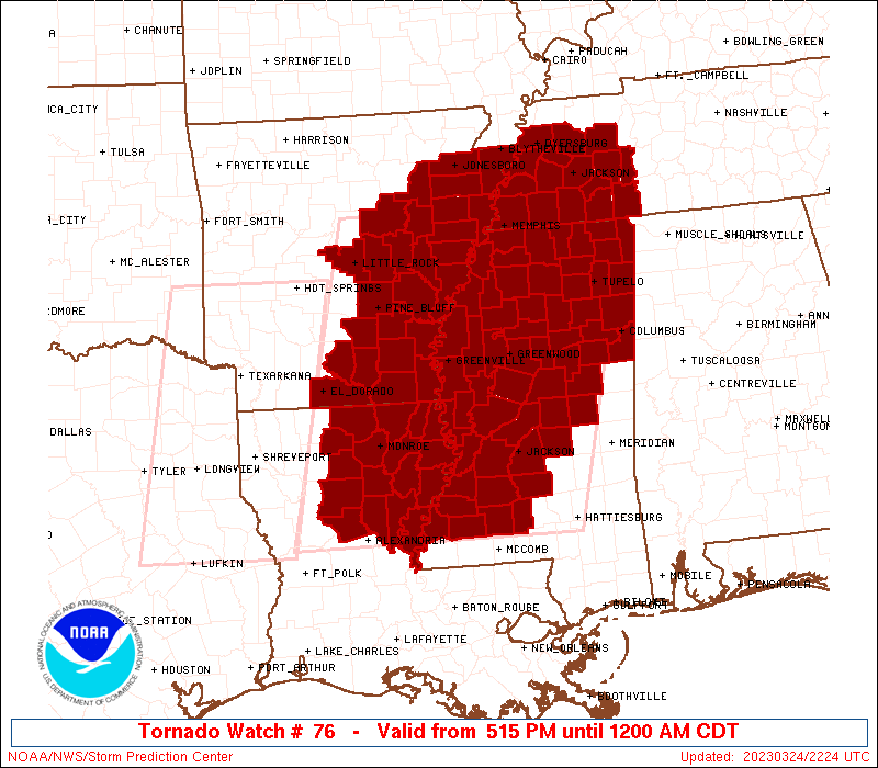
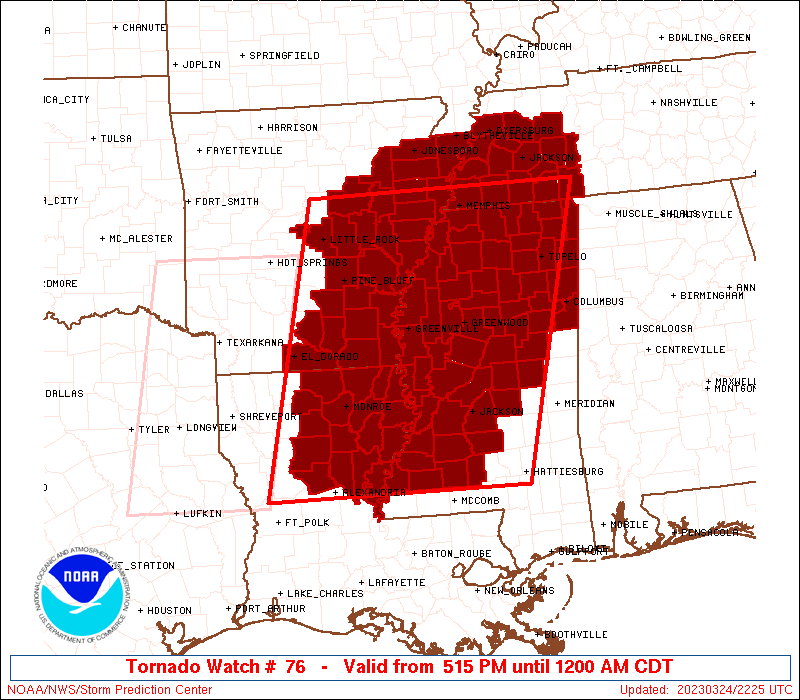
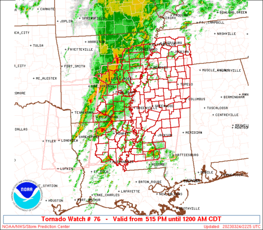
Tornado Watch Number 76
NWS Storm Prediction Center Norman OK
515 PM CDT Fri Mar 24 2023
The NWS Storm Prediction Center has issued a
* Tornado Watch for portions of
Eastern Arkansas
Northeastern Louisiana
Central and northern Mississippi
Western Tennessee
* Effective this Friday afternoon from 515 PM until Midnight CDT.
* Primary threats include...
Several tornadoes and a couple intense tornadoes likely
Widespread damaging winds and isolated significant gusts to 75
mph likely
Scattered large hail events to 1.5 inches in diameter possible
SUMMARY...A maturing squall line will surge eastward from Arkansas
into western Tennessee and northwestern Mississippi through early
tonight, with an accompanying threat for swaths of damaging winds
(up to 75 mph) and tornadoes with embedded circulations. Farther
south, a few semi-discrete supercells are expected ahead of the
squall line, from northeast Louisiana across southeastern Arkansas
and west central/northwestern Mississippi. A few strong-intense
tornadoes will be possible in this corridor with any persistent
supercells later this evening.
The tornado watch area is approximately along and 120 statute miles
east and west of a line from 25 miles northwest of Memphis TN to 20
miles south of Natchez MS. For a complete depiction of the watch see
the associated watch outline update (WOUS64 KWNS WOU6).
PRECAUTIONARY/PREPAREDNESS ACTIONS...
REMEMBER...A Tornado Watch means conditions are favorable for
tornadoes and severe thunderstorms in and close to the watch
area. Persons in these areas should be on the lookout for
threatening weather conditions and listen for later statements
and possible warnings.
&&
OTHER WATCH INFORMATION...CONTINUE...WW 75...
AVIATION...Tornadoes and a few severe thunderstorms with hail
surface and aloft to 1.5 inches. Extreme turbulence and surface wind
gusts to 65 knots. A few cumulonimbi with maximum tops to 500. Mean
storm motion vector 23050.
...Thompson
   SEL6

   URGENT - IMMEDIATE BROADCAST REQUESTED
   Tornado Watch Number 76
   NWS Storm Prediction Center Norman OK
   515 PM CDT Fri Mar 24 2023

   The NWS Storm Prediction Center has issued a

   * Tornado Watch for portions of
     Eastern Arkansas
     Northeastern Louisiana
     Central and northern Mississippi
     Western Tennessee

   * Effective this Friday afternoon from 515 PM until Midnight CDT.

   * Primary threats include...
     Several tornadoes and a couple intense tornadoes likely
     Widespread damaging winds and isolated significant gusts to 75
       mph likely
     Scattered large hail events to 1.5 inches in diameter possible

   SUMMARY...A maturing squall line will surge eastward from Arkansas
   into western Tennessee and northwestern Mississippi through early
   tonight, with an accompanying threat for swaths of damaging winds
   (up to 75 mph) and tornadoes with embedded circulations.  Farther
   south, a few semi-discrete supercells are expected ahead of the
   squall line, from northeast Louisiana across southeastern Arkansas
   and west central/northwestern Mississippi.  A few strong-intense
   tornadoes will be possible in this corridor with any persistent
   supercells later this evening.

   The tornado watch area is approximately along and 120 statute miles
   east and west of a line from 25 miles northwest of Memphis TN to 20
   miles south of Natchez MS. For a complete depiction of the watch see
   the associated watch outline update (WOUS64 KWNS WOU6).

   PRECAUTIONARY/PREPAREDNESS ACTIONS...

   REMEMBER...A Tornado Watch means conditions are favorable for
   tornadoes and severe thunderstorms in and close to the watch
   area. Persons in these areas should be on the lookout for
   threatening weather conditions and listen for later statements
   and possible warnings.

   &&

   OTHER WATCH INFORMATION...CONTINUE...WW 75...

   AVIATION...Tornadoes and a few severe thunderstorms with hail
   surface and aloft to 1.5 inches. Extreme turbulence and surface wind
   gusts to 65 knots. A few cumulonimbi with maximum tops to 500. Mean
   storm motion vector 23050.

   ...Thompson
 Note:
The Aviation Watch (SAW) product is an approximation to the watch area.
The actual watch is depicted by the shaded areas.
Note:
The Aviation Watch (SAW) product is an approximation to the watch area.
The actual watch is depicted by the shaded areas.
   SAW6
   WW 76 TORNADO AR LA MS TN 242215Z - 250500Z
   AXIS..120 STATUTE MILES EAST AND WEST OF LINE..
   25NW MEM/MEMPHIS TN/ - 20S HEZ/NATCHEZ MS/
   ..AVIATION COORDS.. 105NM E/W /21NW MEM - 51N BTR/
   HAIL SURFACE AND ALOFT..1.5 INCHES. WIND GUSTS..65 KNOTS.
   MAX TOPS TO 500. MEAN STORM MOTION VECTOR 23050.

   LAT...LON 35288817 31318927 31319333 35289242

   THIS IS AN APPROXIMATION TO THE WATCH AREA.  FOR A
   COMPLETE DEPICTION OF THE WATCH SEE WOUS64 KWNS
   FOR WOU6.
Watch 76 Status Report Messages:
STATUS REPORT #5 ON WW 76

VALID 250320Z - 250440Z

SEVERE WEATHER THREAT CONTINUES RIGHT OF A LINE FROM 15 ESE ESF
TO 15 E MLU TO 15 NW GWO TO 30 N TUP TO 45 ESE MKL.

..KERR..03/25/23

ATTN...WFO...LZK...JAN...MEG...SHV...

&&

STATUS REPORT FOR WT 76

SEVERE WEATHER THREAT CONTINUES FOR THE FOLLOWING AREAS

LAC025-029-035-041-065-067-083-107-123-250440-

LA
.    LOUISIANA PARISHES INCLUDED ARE

CATAHOULA	     CONCORDIA		 EAST CARROLL
FRANKLIN	     MADISON		 MOREHOUSE
RICHLAND	     TENSAS		 WEST CARROLL
$$


MSC001-007-013-015-017-019-021-023-025-029-037-043-049-051-053-
055-057-061-063-069-075-077-079-081-083-085-087-089-095-097-099-
101-103-105-115-117-121-123-125-127-129-141-149-155-159-161-163-
250440-

MS
.    MISSISSIPPI COUNTIES INCLUDED ARE

ADAMS		     ATTALA		 CALHOUN
CARROLL 	     CHICKASAW		 CHOCTAW
CLAIBORNE	     CLARKE		 CLAY
COPIAH		     FRANKLIN		 GRENADA
HINDS		     HOLMES		 HUMPHREYS
ISSAQUENA	     ITAWAMBA		 JASPER
JEFFERSON	     KEMPER		 LAUDERDALE
LAWRENCE	     LEAKE		 LEE
LEFLORE 	     LINCOLN		 LOWNDES
MADISON 	     MONROE		 MONTGOMERY
NESHOBA 	     NEWTON		 NOXUBEE
OKTIBBEHA	     PONTOTOC		 PRENTISS
RANKIN		     SCOTT		 SHARKEY
SIMPSON 	     SMITH		 TISHOMINGO
WARREN		     WEBSTER		 WINSTON
YALOBUSHA	     YAZOO
$$


TNC071-250440-

TN
.    TENNESSEE COUNTIES INCLUDED ARE

HARDIN
$$


THE WATCH STATUS MESSAGE IS FOR GUIDANCE PURPOSES ONLY.  PLEASE
REFER TO WATCH COUNTY NOTIFICATION STATEMENTS FOR OFFICIAL
INFORMATION ON COUNTIES...INDEPENDENT CITIES AND MARINE ZONES
CLEARED FROM SEVERE THUNDERSTORM AND TORNADO WATCHES.
$$

STATUS REPORT #4 ON WW 76

VALID 250250Z - 250340Z

SEVERE WEATHER THREAT CONTINUES RIGHT OF A LINE FROM 20 WSW ESF
TO 35 NNE MLU TO 55 SSW MEM TO 20 SSW MKL.

..KERR..03/25/23

ATTN...WFO...LZK...JAN...MEG...SHV...

&&

STATUS REPORT FOR WT 76

SEVERE WEATHER THREAT CONTINUES FOR THE FOLLOWING AREAS

ARC003-017-250340-

AR
.    ARKANSAS COUNTIES INCLUDED ARE

ASHLEY		     CHICOT
$$


LAC025-029-035-041-065-067-083-107-123-250340-

LA
.    LOUISIANA PARISHES INCLUDED ARE

CATAHOULA	     CONCORDIA		 EAST CARROLL
FRANKLIN	     MADISON		 MOREHOUSE
RICHLAND	     TENSAS		 WEST CARROLL
$$


MSC001-003-007-009-011-013-015-017-019-021-023-025-029-037-043-
049-051-053-055-057-061-063-069-071-075-077-079-081-083-085-087-
089-093-095-097-099-101-103-105-107-115-117-119-121-123-125-127-
129-133-135-139-141-145-149-151-155-159-161-163-250340-

MS
.    MISSISSIPPI COUNTIES INCLUDED ARE

ADAMS		     ALCORN		 ATTALA
BENTON		     BOLIVAR		 CALHOUN
CARROLL 	     CHICKASAW		 CHOCTAW
CLAIBORNE	     CLARKE		 CLAY
COPIAH		     FRANKLIN		 GRENADA
HINDS		     HOLMES		 HUMPHREYS
ISSAQUENA	     ITAWAMBA		 JASPER
JEFFERSON	     KEMPER		 LAFAYETTE
LAUDERDALE	     LAWRENCE		 LEAKE
LEE		     LEFLORE		 LINCOLN
LOWNDES 	     MADISON		 MARSHALL
MONROE		     MONTGOMERY 	 NESHOBA
NEWTON		     NOXUBEE		 OKTIBBEHA
PANOLA		     PONTOTOC		 PRENTISS
QUITMAN 	     RANKIN		 SCOTT
SHARKEY 	     SIMPSON		 SMITH
SUNFLOWER	     TALLAHATCHIE	 TIPPAH
TISHOMINGO	     UNION		 WARREN
WASHINGTON	     WEBSTER		 WINSTON
YALOBUSHA	     YAZOO
$$


TNC017-023-039-069-071-077-109-113-250340-

TN
.    TENNESSEE COUNTIES INCLUDED ARE

CARROLL 	     CHESTER		 DECATUR
HARDEMAN	     HARDIN		 HENDERSON
MCNAIRY 	     MADISON
$$


THE WATCH STATUS MESSAGE IS FOR GUIDANCE PURPOSES ONLY.  PLEASE
REFER TO WATCH COUNTY NOTIFICATION STATEMENTS FOR OFFICIAL
INFORMATION ON COUNTIES...INDEPENDENT CITIES AND MARINE ZONES
CLEARED FROM SEVERE THUNDERSTORM AND TORNADO WATCHES.
$$

STATUS REPORT #3 ON WW 76

VALID 250035Z - 250140Z

SEVERE WEATHER THREAT CONTINUES RIGHT OF A LINE FROM 35 ESE SHV
TO 25 W MLU TO 55 ENE LIT TO 15 E ARG.

FOR ADDITIONAL INFORMATION SEE MESOSCALE DISCUSSION 328

..THORNTON..03/25/23

ATTN...WFO...LZK...JAN...MEG...SHV...

&&

STATUS REPORT FOR WT 76

SEVERE WEATHER THREAT CONTINUES FOR THE FOLLOWING AREAS

ARC001-003-017-031-035-037-041-043-077-079-093-095-107-111-123-
250140-

AR
.    ARKANSAS COUNTIES INCLUDED ARE

ARKANSAS	     ASHLEY		 CHICOT
CRAIGHEAD	     CRITTENDEN 	 CROSS
DESHA		     DREW		 LEE
LINCOLN 	     MISSISSIPPI	 MONROE
PHILLIPS	     POINSETT		 ST. FRANCIS
$$


LAC021-025-029-035-041-043-049-059-065-067-073-083-107-111-123-
127-250140-

LA
.    LOUISIANA PARISHES INCLUDED ARE

CALDWELL	     CATAHOULA		 CONCORDIA
EAST CARROLL	     FRANKLIN		 GRANT
JACKSON 	     LA SALLE		 MADISON
MOREHOUSE	     OUACHITA		 RICHLAND
TENSAS		     UNION		 WEST CARROLL
WINN
$$


MSC001-003-007-009-011-013-015-017-019-021-023-025-027-029-033-
037-043-049-051-053-055-057-061-063-069-071-075-077-079-081-083-
085-087-089-093-095-097-099-101-103-105-107-115-117-119-121-123-
125-127-129-133-135-137-139-141-143-145-149-151-155-159-161-163-
250140-

MS
.    MISSISSIPPI COUNTIES INCLUDED ARE

ADAMS		     ALCORN		 ATTALA
BENTON		     BOLIVAR		 CALHOUN
CARROLL 	     CHICKASAW		 CHOCTAW
CLAIBORNE	     CLARKE		 CLAY
COAHOMA 	     COPIAH		 DESOTO
FRANKLIN	     GRENADA		 HINDS
HOLMES		     HUMPHREYS		 ISSAQUENA
ITAWAMBA	     JASPER		 JEFFERSON
KEMPER		     LAFAYETTE		 LAUDERDALE
LAWRENCE	     LEAKE		 LEE
LEFLORE 	     LINCOLN		 LOWNDES
MADISON 	     MARSHALL		 MONROE
MONTGOMERY	     NESHOBA		 NEWTON
NOXUBEE 	     OKTIBBEHA		 PANOLA
PONTOTOC	     PRENTISS		 QUITMAN
RANKIN		     SCOTT		 SHARKEY
SIMPSON 	     SMITH		 SUNFLOWER
TALLAHATCHIE	     TATE		 TIPPAH
TISHOMINGO	     TUNICA		 UNION
WARREN		     WASHINGTON 	 WEBSTER
WINSTON 	     YALOBUSHA		 YAZOO
$$


TNC017-023-033-039-045-047-053-069-071-075-077-097-109-113-157-
167-250140-

TN
.    TENNESSEE COUNTIES INCLUDED ARE

CARROLL 	     CHESTER		 CROCKETT
DECATUR 	     DYER		 FAYETTE
GIBSON		     HARDEMAN		 HARDIN
HAYWOOD 	     HENDERSON		 LAUDERDALE
MCNAIRY 	     MADISON		 SHELBY
TIPTON
$$


THE WATCH STATUS MESSAGE IS FOR GUIDANCE PURPOSES ONLY.  PLEASE
REFER TO WATCH COUNTY NOTIFICATION STATEMENTS FOR OFFICIAL
INFORMATION ON COUNTIES...INDEPENDENT CITIES AND MARINE ZONES
CLEARED FROM SEVERE THUNDERSTORM AND TORNADO WATCHES.
$$

STATUS REPORT #2 ON WW 76

VALID 242340Z - 250040Z

SEVERE WEATHER THREAT CONTINUES RIGHT OF A LINE FROM 35 WSW ELD
TO 45 ENE LIT TO 25 ESE BVX.

FOR ADDITIONAL INFORMATION SEE MESOSCALE DISCUSSION 327

..THORNTON..03/24/23

ATTN...WFO...LZK...JAN...MEG...SHV...

&&

STATUS REPORT FOR WT 76

SEVERE WEATHER THREAT CONTINUES FOR THE FOLLOWING AREAS

ARC001-003-011-013-017-025-031-035-037-041-043-069-077-079-093-
095-107-111-123-139-147-250040-

AR
.    ARKANSAS COUNTIES INCLUDED ARE

ARKANSAS	     ASHLEY		 BRADLEY
CALHOUN 	     CHICOT		 CLEVELAND
CRAIGHEAD	     CRITTENDEN 	 CROSS
DESHA		     DREW		 JEFFERSON
LEE		     LINCOLN		 MISSISSIPPI
MONROE		     PHILLIPS		 POINSETT
ST. FRANCIS	     UNION		 WOODRUFF
$$


LAC021-025-029-035-041-043-049-059-061-065-067-073-083-107-111-
123-127-250040-

LA
.    LOUISIANA PARISHES INCLUDED ARE

CALDWELL	     CATAHOULA		 CONCORDIA
EAST CARROLL	     FRANKLIN		 GRANT
JACKSON 	     LA SALLE		 LINCOLN
MADISON 	     MOREHOUSE		 OUACHITA
RICHLAND	     TENSAS		 UNION
WEST CARROLL	     WINN
$$


MSC001-003-007-009-011-013-015-017-019-021-023-025-027-029-033-
037-043-049-051-053-055-057-061-063-069-071-075-077-079-081-083-
085-087-089-093-095-097-099-101-103-105-107-115-117-119-121-123-
125-127-129-133-135-137-139-141-143-145-149-151-155-159-161-163-
250040-

MS
.    MISSISSIPPI COUNTIES INCLUDED ARE

ADAMS		     ALCORN		 ATTALA
BENTON		     BOLIVAR		 CALHOUN
CARROLL 	     CHICKASAW		 CHOCTAW
CLAIBORNE	     CLARKE		 CLAY
COAHOMA 	     COPIAH		 DESOTO
FRANKLIN	     GRENADA		 HINDS
HOLMES		     HUMPHREYS		 ISSAQUENA
ITAWAMBA	     JASPER		 JEFFERSON
KEMPER		     LAFAYETTE		 LAUDERDALE
LAWRENCE	     LEAKE		 LEE
LEFLORE 	     LINCOLN		 LOWNDES
MADISON 	     MARSHALL		 MONROE
MONTGOMERY	     NESHOBA		 NEWTON
NOXUBEE 	     OKTIBBEHA		 PANOLA
PONTOTOC	     PRENTISS		 QUITMAN
RANKIN		     SCOTT		 SHARKEY
SIMPSON 	     SMITH		 SUNFLOWER
TALLAHATCHIE	     TATE		 TIPPAH
TISHOMINGO	     TUNICA		 UNION
WARREN		     WASHINGTON 	 WEBSTER
WINSTON 	     YALOBUSHA		 YAZOO
$$


TNC017-023-033-039-045-047-053-069-071-075-077-097-109-113-157-
167-250040-

TN
.    TENNESSEE COUNTIES INCLUDED ARE

CARROLL 	     CHESTER		 CROCKETT
DECATUR 	     DYER		 FAYETTE
GIBSON		     HARDEMAN		 HARDIN
HAYWOOD 	     HENDERSON		 LAUDERDALE
MCNAIRY 	     MADISON		 SHELBY
TIPTON
$$


THE WATCH STATUS MESSAGE IS FOR GUIDANCE PURPOSES ONLY.  PLEASE
REFER TO WATCH COUNTY NOTIFICATION STATEMENTS FOR OFFICIAL
INFORMATION ON COUNTIES...INDEPENDENT CITIES AND MARINE ZONES
CLEARED FROM SEVERE THUNDERSTORM AND TORNADO WATCHES.
$$

STATUS REPORT #1 ON WW 76

VALID 242255Z - 242340Z

THE SEVERE WEATHER THREAT CONTINUES ACROSS THE ENTIRE WATCH AREA.

FOR ADDITIONAL INFORMATION SEE MESOSCALE DISCUSSION 325

..THORNTON..03/24/23

ATTN...WFO...LZK...JAN...MEG...SHV...

&&

STATUS REPORT FOR WT 76

SEVERE WEATHER THREAT CONTINUES FOR THE FOLLOWING AREAS

ARC001-003-011-013-017-025-031-035-037-041-043-067-069-077-079-
085-093-095-107-111-117-119-123-139-145-147-242340-

AR
.    ARKANSAS COUNTIES INCLUDED ARE

ARKANSAS	     ASHLEY		 BRADLEY
CALHOUN 	     CHICOT		 CLEVELAND
CRAIGHEAD	     CRITTENDEN 	 CROSS
DESHA		     DREW		 JACKSON
JEFFERSON	     LEE		 LINCOLN
LONOKE		     MISSISSIPPI	 MONROE
PHILLIPS	     POINSETT		 PRAIRIE
PULASKI 	     ST. FRANCIS	 UNION
WHITE		     WOODRUFF
$$


LAC021-025-029-035-041-043-049-059-061-065-067-073-083-107-111-
123-127-242340-

LA
.    LOUISIANA PARISHES INCLUDED ARE

CALDWELL	     CATAHOULA		 CONCORDIA
EAST CARROLL	     FRANKLIN		 GRANT
JACKSON 	     LA SALLE		 LINCOLN
MADISON 	     MOREHOUSE		 OUACHITA
RICHLAND	     TENSAS		 UNION
WEST CARROLL	     WINN
$$


MSC001-003-007-009-011-013-015-017-019-021-025-027-029-033-037-
043-049-051-053-055-057-063-071-077-079-081-083-085-087-089-093-
095-097-099-105-107-115-117-119-121-123-125-127-133-135-137-139-
141-143-145-149-151-155-159-161-163-242340-

MS
.    MISSISSIPPI COUNTIES INCLUDED ARE

ADAMS		     ALCORN		 ATTALA
BENTON		     BOLIVAR		 CALHOUN
CARROLL 	     CHICKASAW		 CHOCTAW
CLAIBORNE	     CLAY		 COAHOMA
COPIAH		     DESOTO		 FRANKLIN
GRENADA 	     HINDS		 HOLMES
HUMPHREYS	     ISSAQUENA		 ITAWAMBA
JEFFERSON	     LAFAYETTE		 LAWRENCE
LEAKE		     LEE		 LEFLORE
LINCOLN 	     LOWNDES		 MADISON
MARSHALL	     MONROE		 MONTGOMERY
NESHOBA 	     OKTIBBEHA		 PANOLA
PONTOTOC	     PRENTISS		 QUITMAN
RANKIN		     SCOTT		 SHARKEY
SIMPSON 	     SUNFLOWER		 TALLAHATCHIE
TATE		     TIPPAH		 TISHOMINGO
TUNICA		     UNION		 WARREN
WASHINGTON	     WEBSTER		 WINSTON
YALOBUSHA	     YAZOO
$$


TNC017-023-033-039-045-047-053-069-071-075-077-097-109-113-157-
167-242340-

TN
.    TENNESSEE COUNTIES INCLUDED ARE

CARROLL 	     CHESTER		 CROCKETT
DECATUR 	     DYER		 FAYETTE
GIBSON		     HARDEMAN		 HARDIN
HAYWOOD 	     HENDERSON		 LAUDERDALE
MCNAIRY 	     MADISON		 SHELBY
TIPTON
$$


THE WATCH STATUS MESSAGE IS FOR GUIDANCE PURPOSES ONLY.  PLEASE
REFER TO WATCH COUNTY NOTIFICATION STATEMENTS FOR OFFICIAL
INFORMATION ON COUNTIES...INDEPENDENT CITIES AND MARINE ZONES
CLEARED FROM SEVERE THUNDERSTORM AND TORNADO WATCHES.
$$
Note:
Click for Complete Product Text.
Tornadoes
Probability of 2 or more tornadoes
|
High (90%)
|
Probability of 1 or more strong (EF2-EF5) tornadoes
|
High (70%)
|
Wind
Probability of 10 or more severe wind events
|
High (80%)
|
Probability of 1 or more wind events > 65 knots
|
High (70%)
|
Hail
Probability of 10 or more severe hail events
|
Mod (40%)
|
Probability of 1 or more hailstones > 2 inches
|
Low (10%)
|
Combined Severe Hail/Wind
Probability of 6 or more combined severe hail/wind events
|
High (>95%)
|
For each watch, probabilities for particular events inside the watch
(listed above in each table) are determined by the issuing forecaster.
The "Low" category contains probability values ranging from less than 2%
to 20% (EF2-EF5 tornadoes), less than 5% to 20% (all other probabilities),
"Moderate" from 30% to 60%, and "High" from 70% to greater than 95%.
High values are bolded and lighter in color to provide awareness of
an increased threat for a particular event.


 @NWSSPC