Note:
The expiration time in the watch graphic is amended if the watch is
replaced, cancelled or extended.
Note:
Note:
The expiration time in the watch graphic is amended if the watch is
replaced, cancelled or extended.
Note: Click for
Watch Status Reports.
SEL4
URGENT - IMMEDIATE BROADCAST REQUESTED
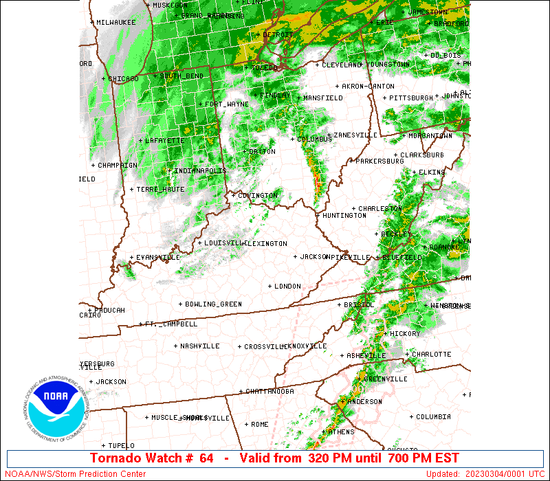
Tornado Watch Number 64
NWS Storm Prediction Center Norman OK
320 PM EST Fri Mar 3 2023
The NWS Storm Prediction Center has issued a
* Tornado Watch for portions of
Extreme southeast Indiana
Eastern Kentucky
Southern Ohio
Far southwest Virginia
Southwest West Virginia
* Effective this Friday afternoon and evening from 320 PM until
700 PM EST.
* Primary threats include...
A couple tornadoes possible
Scattered damaging wind gusts to 70 mph possible
SUMMARY...Conditional tornado and damaging wind potential will exist
for a few more hours with low-topped convection spreading east
across the Ohio Valley and Cumberland Plateau.
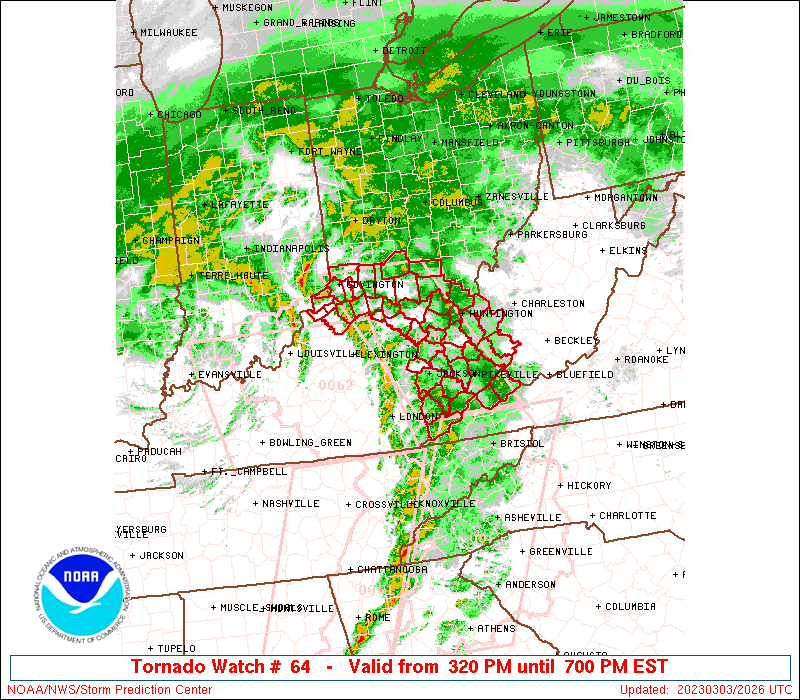
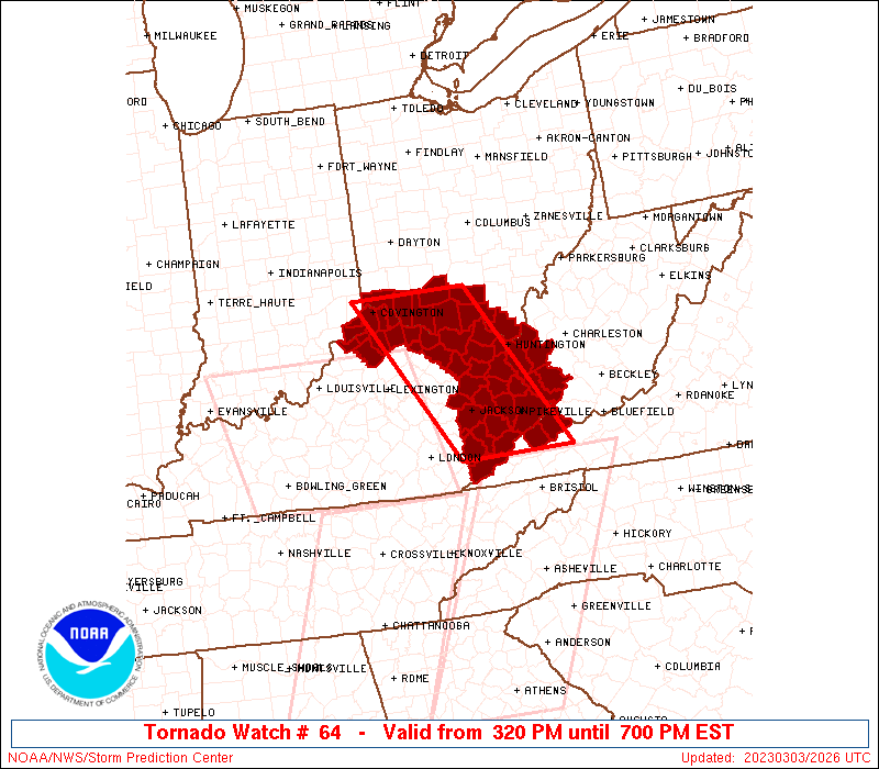
The tornado watch area is approximately along and 50 statute miles
east and west of a line from 20 miles east northeast of Cincinnati
OH to 55 miles southeast of Jackson KY. For a complete depiction of
the watch see the associated watch outline update (WOUS64 KWNS
WOU4).
PRECAUTIONARY/PREPAREDNESS ACTIONS...
REMEMBER...A Tornado Watch means conditions are favorable for
tornadoes and severe thunderstorms in and close to the watch
area. Persons in these areas should be on the lookout for
threatening weather conditions and listen for later statements
and possible warnings.
&&
OTHER WATCH INFORMATION...CONTINUE...WW 61...WW 62...WW 63...
AVIATION...Tornadoes and a few severe thunderstorms with hail
surface and aloft to 0.5 inches. Extreme turbulence and surface wind
gusts to 60 knots. A few cumulonimbi with maximum tops to 300. Mean
storm motion vector 24050.
...Grams
 Note:
The Aviation Watch (SAW) product is an approximation to the watch area.
The actual watch is depicted by the shaded areas.
Note:
The Aviation Watch (SAW) product is an approximation to the watch area.
The actual watch is depicted by the shaded areas.
   SAW4
   WW 64 TORNADO IN KY OH VA WV 032020Z - 040000Z
   AXIS..50 STATUTE MILES EAST AND WEST OF LINE..
   20ENE LUK/CINCINNATI OH/ - 55SE JKL/JACKSON KY/
   ..AVIATION COORDS.. 45NM E/W /31ENE CVG - 41NW HMV/
   HAIL SURFACE AND ALOFT..0.5 INCH. WIND GUSTS..60 KNOTS.
   MAX TOPS TO 300. MEAN STORM MOTION VECTOR 24050.

   LAT...LON 39218314 36978176 36978358 39218501

   THIS IS AN APPROXIMATION TO THE WATCH AREA.  FOR A
   COMPLETE DEPICTION OF THE WATCH SEE WOUS64 KWNS
   FOR WOU4.
Watch 64 Status Report Messages:
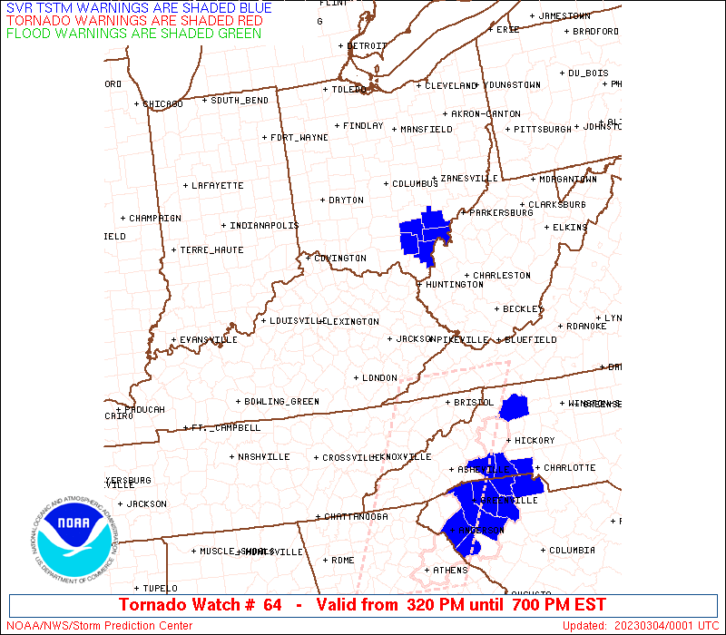
STATUS REPORT #2 ON WW 64

VALID 032235Z - 032340Z

SEVERE WEATHER THREAT CONTINUES RIGHT OF A LINE FROM 30 N TRI TO
60 WNW BLF TO 15 S HTS TO 40 WNW HTS TO 35 ESE LUK TO 15 NNE LUK.

FOR ADDITIONAL INFORMATION SEE MESOSCALE DISCUSSION 250

..MOORE..03/03/23

ATTN...WFO...ILN...RLX...JKL...

&&

STATUS REPORT FOR WT 64

SEVERE WEATHER THREAT CONTINUES FOR THE FOLLOWING AREAS

KYC019-089-032340-

KY
.    KENTUCKY COUNTIES INCLUDED ARE

BOYD		     GREENUP
$$


OHC001-015-071-087-131-145-032340-

OH
.    OHIO COUNTIES INCLUDED ARE

ADAMS		     BROWN		 HIGHLAND
LAWRENCE	     PIKE		 SCIOTO
$$


VAC027-051-032340-

VA
.    VIRGINIA COUNTIES INCLUDED ARE

BUCHANAN	     DICKENSON
$$


WVC011-043-045-059-099-032340-

WV
.    WEST VIRGINIA COUNTIES INCLUDED ARE

CABELL		     LINCOLN		 LOGAN
MINGO		     WAYNE
$$


THE WATCH STATUS MESSAGE IS FOR GUIDANCE PURPOSES ONLY.  PLEASE
REFER TO WATCH COUNTY NOTIFICATION STATEMENTS FOR OFFICIAL
INFORMATION ON COUNTIES...INDEPENDENT CITIES AND MARINE ZONES
CLEARED FROM SEVERE THUNDERSTORM AND TORNADO WATCHES.
$$

STATUS REPORT #1 ON WW 64

VALID 032140Z - 032240Z

SEVERE WEATHER THREAT CONTINUES RIGHT OF A LINE FROM 40 WNW TRI
TO 20 ESE JKL TO 35 ENE LEX TO 55 N SDF.

..MOORE..03/03/23

ATTN...WFO...ILN...RLX...JKL...

&&

STATUS REPORT FOR WT 64

SEVERE WEATHER THREAT CONTINUES FOR THE FOLLOWING AREAS

INC115-155-032240-

IN
.    INDIANA COUNTIES INCLUDED ARE

OHIO		     SWITZERLAND
$$


KYC015-019-023-037-043-063-069-071-077-081-089-115-117-119-127-
133-135-153-159-161-175-191-195-201-205-032240-

KY
.    KENTUCKY COUNTIES INCLUDED ARE

BOONE		     BOYD		 BRACKEN
CAMPBELL	     CARTER		 ELLIOTT
FLEMING 	     FLOYD		 GALLATIN
GRANT		     GREENUP		 JOHNSON
KENTON		     KNOTT		 LAWRENCE
LETCHER 	     LEWIS		 MAGOFFIN
MARTIN		     MASON		 MORGAN
PENDLETON	     PIKE		 ROBERTSON
ROWAN
$$


OHC001-015-025-061-071-087-131-145-032240-

OH
.    OHIO COUNTIES INCLUDED ARE

ADAMS		     BROWN		 CLERMONT
HAMILTON	     HIGHLAND		 LAWRENCE
PIKE		     SCIOTO
$$


VAC027-051-032240-

VA
.    VIRGINIA COUNTIES INCLUDED ARE

BUCHANAN	     DICKENSON
$$


WVC011-043-045-059-099-032240-

WV
.    WEST VIRGINIA COUNTIES INCLUDED ARE

CABELL		     LINCOLN		 LOGAN
MINGO		     WAYNE
$$


THE WATCH STATUS MESSAGE IS FOR GUIDANCE PURPOSES ONLY.  PLEASE
REFER TO WATCH COUNTY NOTIFICATION STATEMENTS FOR OFFICIAL
INFORMATION ON COUNTIES...INDEPENDENT CITIES AND MARINE ZONES
CLEARED FROM SEVERE THUNDERSTORM AND TORNADO WATCHES.
$$
Note:
Click for Complete Product Text.
Tornadoes
Probability of 2 or more tornadoes
|
Mod (30%)
|
Probability of 1 or more strong (EF2-EF5) tornadoes
|
Low (20%)
|
Wind
Probability of 10 or more severe wind events
|
Mod (40%)
|
Probability of 1 or more wind events > 65 knots
|
Low (20%)
|
Hail
Probability of 10 or more severe hail events
|
Low (<5%)
|
Probability of 1 or more hailstones > 2 inches
|
Low (<5%)
|
Combined Severe Hail/Wind
Probability of 6 or more combined severe hail/wind events
|
Mod (50%)
|
For each watch, probabilities for particular events inside the watch
(listed above in each table) are determined by the issuing forecaster.
The "Low" category contains probability values ranging from less than 2%
to 20% (EF2-EF5 tornadoes), less than 5% to 20% (all other probabilities),
"Moderate" from 30% to 60%, and "High" from 70% to greater than 95%.
High values are bolded and lighter in color to provide awareness of
an increased threat for a particular event.


 @NWSSPC