 Note:
The expiration time in the watch graphic is amended if the watch is
replaced, cancelled or extended.
Note:
Note:
The expiration time in the watch graphic is amended if the watch is
replaced, cancelled or extended.
Note: Click for
Watch Status Reports.
SEL2
URGENT - IMMEDIATE BROADCAST REQUESTED
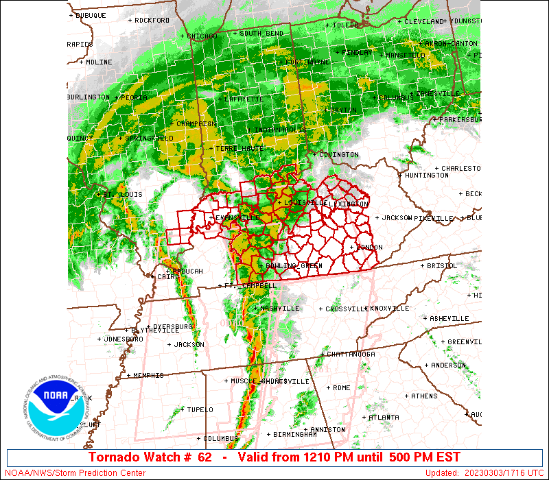
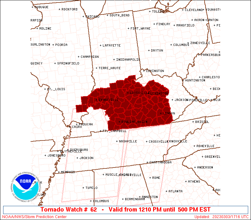
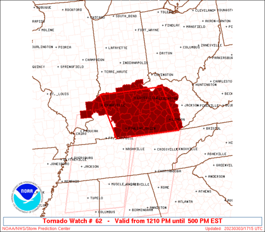
Tornado Watch Number 62
NWS Storm Prediction Center Norman OK
1210 PM EST Fri Mar 3 2023
The NWS Storm Prediction Center has issued a
* Tornado Watch for portions of
Far southeast Illinois
Southern Indiana
Kentucky
* Effective this Friday afternoon from 1210 PM until 500 PM EST.
* Primary threats include...
A few tornadoes likely with a couple intense tornadoes possible
Widespread damaging winds and isolated significant gusts to 85
mph likely
SUMMARY...Low-topped supercells embedded within broken line segments
will sweep east-northeast across the Lower Ohio Valley and Kentucky
through this afternoon. Tornadoes and damaging winds are the primary
hazards.
The tornado watch area is approximately along and 90 statute miles
east and west of a line from 25 miles north northwest of Louisville
KY to 65 miles east southeast of Bowling Green KY. For a complete
depiction of the watch see the associated watch outline update
(WOUS64 KWNS WOU2).
PRECAUTIONARY/PREPAREDNESS ACTIONS...
REMEMBER...A Tornado Watch means conditions are favorable for
tornadoes and severe thunderstorms in and close to the watch
area. Persons in these areas should be on the lookout for
threatening weather conditions and listen for later statements
and possible warnings.
&&
OTHER WATCH INFORMATION...CONTINUE...WW 60...WW 61...
AVIATION...Tornadoes and a few severe thunderstorms with hail
surface and aloft to 1 inch. Extreme turbulence and surface wind
gusts to 75 knots. A few cumulonimbi with maximum tops to 350. Mean
storm motion vector 24055.
...Grams
 Note:
The Aviation Watch (SAW) product is an approximation to the watch area.
The actual watch is depicted by the shaded areas.
Note:
The Aviation Watch (SAW) product is an approximation to the watch area.
The actual watch is depicted by the shaded areas.
   SAW2
   WW 62 TORNADO IL IN KY 031710Z - 032200Z
   AXIS..90 STATUTE MILES EAST AND WEST OF LINE..
   25NNW SDF/LOUISVILLE KY/ - 65ESE BWG/BOWLING GREEN KY/
   ..AVIATION COORDS.. 80NM E/W /29NNW IIU - 57ESE BWG/
   HAIL SURFACE AND ALOFT..1 INCH. WIND GUSTS..75 KNOTS.
   MAX TOPS TO 350. MEAN STORM MOTION VECTOR 24055.

   LAT...LON 38508424 36598371 36598696 38508757

   THIS IS AN APPROXIMATION TO THE WATCH AREA.  FOR A
   COMPLETE DEPICTION OF THE WATCH SEE WOUS64 KWNS
   FOR WOU2.
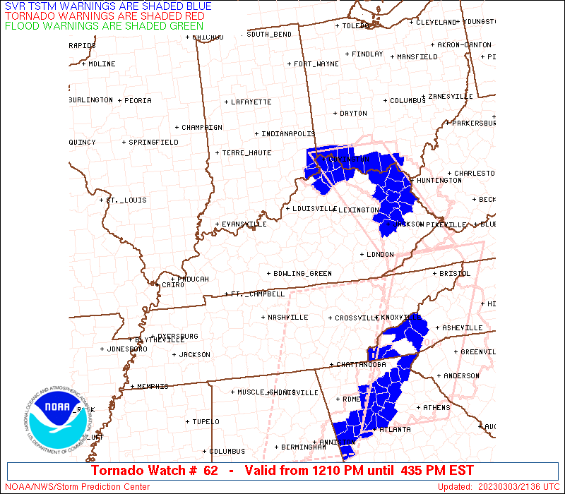
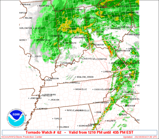
Watch 62 Status Report Messages:
STATUS REPORT #7 ON WW 62

VALID 032110Z - 032240Z

SEVERE WEATHER THREAT CONTINUES RIGHT OF A LINE FROM 35 S LOZ TO
40 N SDF.

..MOORE..03/03/23

ATTN...WFO...PAH...LMK...JKL...

&&

STATUS REPORT FOR WT 62

SEVERE WEATHER THREAT CONTINUES FOR THE FOLLOWING AREAS

INC077-032240-

IN
.    INDIANA COUNTIES INCLUDED ARE

JEFFERSON
$$


KYC005-011-013-017-049-051-065-067-073-079-097-103-109-113-121-
125-129-151-165-167-173-181-185-189-197-203-209-211-223-239-
032240-

KY
.    KENTUCKY COUNTIES INCLUDED ARE

ANDERSON	     BATH		 BELL
BOURBON 	     CLARK		 CLAY
ESTILL		     FAYETTE		 FRANKLIN
GARRARD 	     HARRISON		 HENRY
JACKSON 	     JESSAMINE		 KNOX
LAUREL		     LEE		 MADISON
MENIFEE 	     MERCER		 MONTGOMERY
NICHOLAS	     OLDHAM		 OWSLEY
POWELL		     ROCKCASTLE 	 SCOTT
SHELBY		     TRIMBLE		 WOODFORD
$$


THE WATCH STATUS MESSAGE IS FOR GUIDANCE PURPOSES ONLY.  PLEASE
REFER TO WATCH COUNTY NOTIFICATION STATEMENTS FOR OFFICIAL
INFORMATION ON COUNTIES...INDEPENDENT CITIES AND MARINE ZONES
CLEARED FROM SEVERE THUNDERSTORM AND TORNADO WATCHES.
$$

STATUS REPORT #6 ON WW 62

VALID 032040Z - 032140Z

SEVERE WEATHER THREAT CONTINUES RIGHT OF A LINE FROM 45 SSW LOZ
TO 40 W LOZ TO 30 SSE SDF TO 35 NNW SDF.

FOR ADDITIONAL INFORMATION SEE MESOSCALE DISCUSSION 248

..MOORE..03/03/23

ATTN...WFO...PAH...LMK...JKL...

&&

STATUS REPORT FOR WT 62

SEVERE WEATHER THREAT CONTINUES FOR THE FOLLOWING AREAS

INC019-077-143-032140-

IN
.    INDIANA COUNTIES INCLUDED ARE

CLARK		     JEFFERSON		 SCOTT
$$


KYC005-011-013-017-021-045-049-051-065-067-073-079-097-103-109-
113-121-125-129-137-147-151-155-165-167-173-179-181-185-189-197-
199-203-209-211-215-223-229-235-239-032140-

KY
.    KENTUCKY COUNTIES INCLUDED ARE

ANDERSON	     BATH		 BELL
BOURBON 	     BOYLE		 CASEY
CLARK		     CLAY		 ESTILL
FAYETTE 	     FRANKLIN		 GARRARD
HARRISON	     HENRY		 JACKSON
JESSAMINE	     KNOX		 LAUREL
LEE		     LINCOLN		 MCCREARY
MADISON 	     MARION		 MENIFEE
MERCER		     MONTGOMERY 	 NELSON
NICHOLAS	     OLDHAM		 OWSLEY
POWELL		     PULASKI		 ROCKCASTLE
SCOTT		     SHELBY		 SPENCER
TRIMBLE 	     WASHINGTON 	 WHITLEY
WOODFORD
$$


THE WATCH STATUS MESSAGE IS FOR GUIDANCE PURPOSES ONLY.  PLEASE
REFER TO WATCH COUNTY NOTIFICATION STATEMENTS FOR OFFICIAL
INFORMATION ON COUNTIES...INDEPENDENT CITIES AND MARINE ZONES
CLEARED FROM SEVERE THUNDERSTORM AND TORNADO WATCHES.
$$

STATUS REPORT #5 ON WW 62

VALID 032000Z - 032140Z

SEVERE WEATHER THREAT CONTINUES RIGHT OF A LINE FROM 40 N CSV TO
60 WSW LOZ TO 35 S BMG.

..MOORE..03/03/23

ATTN...WFO...PAH...LMK...JKL...

&&

STATUS REPORT FOR WT 62

SEVERE WEATHER THREAT CONTINUES FOR THE FOLLOWING AREAS

INC019-043-061-077-117-143-175-032140-

IN
.    INDIANA COUNTIES INCLUDED ARE

CLARK		     FLOYD		 HARRISON
JEFFERSON	     ORANGE		 SCOTT
WASHINGTON
$$


KYC001-005-011-013-017-021-029-045-049-051-065-067-073-079-097-
103-109-111-113-121-125-129-137-147-151-155-165-167-173-179-181-
185-189-197-199-203-207-209-211-215-217-223-229-231-235-239-
032140-

KY
.    KENTUCKY COUNTIES INCLUDED ARE

ADAIR		     ANDERSON		 BATH
BELL		     BOURBON		 BOYLE
BULLITT 	     CASEY		 CLARK
CLAY		     ESTILL		 FAYETTE
FRANKLIN	     GARRARD		 HARRISON
HENRY		     JACKSON		 JEFFERSON
JESSAMINE	     KNOX		 LAUREL
LEE		     LINCOLN		 MCCREARY
MADISON 	     MARION		 MENIFEE
MERCER		     MONTGOMERY 	 NELSON
NICHOLAS	     OLDHAM		 OWSLEY
POWELL		     PULASKI		 ROCKCASTLE
RUSSELL 	     SCOTT		 SHELBY
SPENCER 	     TAYLOR		 TRIMBLE
WASHINGTON	     WAYNE		 WHITLEY
WOODFORD
$$


THE WATCH STATUS MESSAGE IS FOR GUIDANCE PURPOSES ONLY.  PLEASE
REFER TO WATCH COUNTY NOTIFICATION STATEMENTS FOR OFFICIAL
INFORMATION ON COUNTIES...INDEPENDENT CITIES AND MARINE ZONES
CLEARED FROM SEVERE THUNDERSTORM AND TORNADO WATCHES.
$$

STATUS REPORT #4 ON WW 62

VALID 031930Z - 032040Z

SEVERE WEATHER THREAT CONTINUES RIGHT OF A LINE FROM 40 NNW CSV
TO 30 NNE BWG TO 30 NE OWB TO 45 N EVV.

..MOORE..03/03/23

ATTN...WFO...PAH...LMK...JKL...

&&

STATUS REPORT FOR WT 62

SEVERE WEATHER THREAT CONTINUES FOR THE FOLLOWING AREAS

INC019-025-037-043-061-077-117-123-143-175-032040-

IN
.    INDIANA COUNTIES INCLUDED ARE

CLARK		     CRAWFORD		 DUBOIS
FLOYD		     HARRISON		 JEFFERSON
ORANGE		     PERRY		 SCOTT
WASHINGTON
$$


KYC001-005-011-013-017-021-027-029-045-049-051-053-057-065-067-
073-079-087-093-097-099-103-109-111-113-121-123-125-129-137-147-
151-155-163-165-167-169-173-179-181-185-189-197-199-203-207-209-
211-215-217-223-229-231-235-239-032040-

KY
.    KENTUCKY COUNTIES INCLUDED ARE

ADAIR		     ANDERSON		 BATH
BELL		     BOURBON		 BOYLE
BRECKINRIDGE	     BULLITT		 CASEY
CLARK		     CLAY		 CLINTON
CUMBERLAND	     ESTILL		 FAYETTE
FRANKLIN	     GARRARD		 GREEN
HARDIN		     HARRISON		 HART
HENRY		     JACKSON		 JEFFERSON
JESSAMINE	     KNOX		 LARUE
LAUREL		     LEE		 LINCOLN
MCCREARY	     MADISON		 MARION
MEADE		     MENIFEE		 MERCER
METCALFE	     MONTGOMERY 	 NELSON
NICHOLAS	     OLDHAM		 OWSLEY
POWELL		     PULASKI		 ROCKCASTLE
RUSSELL 	     SCOTT		 SHELBY
SPENCER 	     TAYLOR		 TRIMBLE
WASHINGTON	     WAYNE		 WHITLEY
WOODFORD
$$


THE WATCH STATUS MESSAGE IS FOR GUIDANCE PURPOSES ONLY.  PLEASE
REFER TO WATCH COUNTY NOTIFICATION STATEMENTS FOR OFFICIAL
INFORMATION ON COUNTIES...INDEPENDENT CITIES AND MARINE ZONES
CLEARED FROM SEVERE THUNDERSTORM AND TORNADO WATCHES.
$$

STATUS REPORT #3 ON WW 62

VALID 031920Z - 032040Z

SEVERE WEATHER THREAT CONTINUES RIGHT OF A LINE FROM 40 SE BWG TO
25 E OWB TO 40 NNW EVV.

FOR ADDITIONAL INFORMATION SEE MESOSCALE DISCUSSION 245

..MOORE..03/03/23

ATTN...WFO...PAH...LMK...JKL...

&&

STATUS REPORT FOR WT 62

SEVERE WEATHER THREAT CONTINUES FOR THE FOLLOWING AREAS

INC019-025-037-043-061-077-117-123-125-143-147-175-032040-

IN
.    INDIANA COUNTIES INCLUDED ARE

CLARK		     CRAWFORD		 DUBOIS
FLOYD		     HARRISON		 JEFFERSON
ORANGE		     PERRY		 PIKE
SCOTT		     SPENCER		 WASHINGTON
$$


KYC001-005-009-011-013-017-021-027-029-045-049-051-053-057-061-
065-067-073-079-085-087-091-093-097-099-103-109-111-113-121-123-
125-129-137-147-151-155-163-165-167-169-171-173-179-181-185-189-
197-199-203-207-209-211-215-217-223-229-231-235-239-032040-

KY
.    KENTUCKY COUNTIES INCLUDED ARE

ADAIR		     ANDERSON		 BARREN
BATH		     BELL		 BOURBON
BOYLE		     BRECKINRIDGE	 BULLITT
CASEY		     CLARK		 CLAY
CLINTON 	     CUMBERLAND 	 EDMONSON
ESTILL		     FAYETTE		 FRANKLIN
GARRARD 	     GRAYSON		 GREEN
HANCOCK 	     HARDIN		 HARRISON
HART		     HENRY		 JACKSON
JEFFERSON	     JESSAMINE		 KNOX
LARUE		     LAUREL		 LEE
LINCOLN 	     MCCREARY		 MADISON
MARION		     MEADE		 MENIFEE
MERCER		     METCALFE		 MONROE
MONTGOMERY	     NELSON		 NICHOLAS
OLDHAM		     OWSLEY		 POWELL
PULASKI 	     ROCKCASTLE 	 RUSSELL
SCOTT		     SHELBY		 SPENCER
TAYLOR		     TRIMBLE		 WASHINGTON
WAYNE		     WHITLEY		 WOODFORD
$$


THE WATCH STATUS MESSAGE IS FOR GUIDANCE PURPOSES ONLY.  PLEASE
REFER TO WATCH COUNTY NOTIFICATION STATEMENTS FOR OFFICIAL
INFORMATION ON COUNTIES...INDEPENDENT CITIES AND MARINE ZONES
CLEARED FROM SEVERE THUNDERSTORM AND TORNADO WATCHES.
$$

STATUS REPORT #2 ON WW 62

VALID 031835Z - 031940Z

SEVERE WEATHER THREAT CONTINUES RIGHT OF A LINE FROM 15 ESE CKV
TO 25 WSW OWB TO 25 ENE MVN.

FOR ADDITIONAL INFORMATION SEE MESOSCALE DISCUSSION 245

..MOORE..03/03/23

ATTN...WFO...PAH...LMK...JKL...

&&

STATUS REPORT FOR WT 62

SEVERE WEATHER THREAT CONTINUES FOR THE FOLLOWING AREAS

INC019-025-037-043-051-061-077-117-123-125-129-143-147-163-173-
175-031940-

IN
.    INDIANA COUNTIES INCLUDED ARE

CLARK		     CRAWFORD		 DUBOIS
FLOYD		     GIBSON		 HARRISON
JEFFERSON	     ORANGE		 PERRY
PIKE		     POSEY		 SCOTT
SPENCER 	     VANDERBURGH	 WARRICK
WASHINGTON
$$


KYC001-003-005-009-011-013-017-021-027-029-031-045-049-051-053-
057-059-061-065-067-073-079-085-087-091-093-097-099-101-103-109-
111-113-121-123-125-129-137-141-147-151-155-163-165-167-169-171-
173-179-181-183-185-189-197-199-203-207-209-211-213-215-217-223-
227-229-231-235-239-031940-

KY
.    KENTUCKY COUNTIES INCLUDED ARE

ADAIR		     ALLEN		 ANDERSON
BARREN		     BATH		 BELL
BOURBON 	     BOYLE		 BRECKINRIDGE
BULLITT 	     BUTLER		 CASEY
CLARK		     CLAY		 CLINTON
CUMBERLAND	     DAVIESS		 EDMONSON
ESTILL		     FAYETTE		 FRANKLIN
GARRARD 	     GRAYSON		 GREEN
HANCOCK 	     HARDIN		 HARRISON
HART		     HENDERSON		 HENRY
JACKSON 	     JEFFERSON		 JESSAMINE
KNOX		     LARUE		 LAUREL
LEE		     LINCOLN		 LOGAN
MCCREARY	     MADISON		 MARION
MEADE		     MENIFEE		 MERCER
METCALFE	     MONROE		 MONTGOMERY
NELSON		     NICHOLAS		 OHIO
OLDHAM		     OWSLEY		 POWELL
PULASKI 	     ROCKCASTLE 	 RUSSELL
SCOTT		     SHELBY		 SIMPSON
SPENCER 	     TAYLOR		 TRIMBLE
WARREN		     WASHINGTON 	 WAYNE
WHITLEY 	     WOODFORD
$$


THE WATCH STATUS MESSAGE IS FOR GUIDANCE PURPOSES ONLY.  PLEASE
REFER TO WATCH COUNTY NOTIFICATION STATEMENTS FOR OFFICIAL
INFORMATION ON COUNTIES...INDEPENDENT CITIES AND MARINE ZONES
CLEARED FROM SEVERE THUNDERSTORM AND TORNADO WATCHES.
$$

STATUS REPORT #1 ON WW 62

VALID 031830Z - 031940Z

SEVERE WEATHER THREAT CONTINUES RIGHT OF A LINE FROM 10 ESE CKV
TO 35 N HOP TO 30 SW EVV TO 35 WSW EVV TO 30 SE MVN.

FOR ADDITIONAL INFORMATION SEE MESOSCALE DISCUSSION 245

..JEWELL..03/03/23

ATTN...WFO...PAH...LMK...JKL...

&&

STATUS REPORT FOR WT 62

SEVERE WEATHER THREAT CONTINUES FOR THE FOLLOWING AREAS

ILC193-031940-

IL
.    ILLINOIS COUNTIES INCLUDED ARE

WHITE
$$


INC019-025-037-043-051-061-077-117-123-125-129-143-147-163-173-
175-031940-

IN
.    INDIANA COUNTIES INCLUDED ARE

CLARK		     CRAWFORD		 DUBOIS
FLOYD		     GIBSON		 HARRISON
JEFFERSON	     ORANGE		 PERRY
PIKE		     POSEY		 SCOTT
SPENCER 	     VANDERBURGH	 WARRICK
WASHINGTON
$$


KYC001-003-005-009-011-013-017-021-027-029-031-045-049-051-053-
057-059-061-065-067-073-079-085-087-091-093-097-099-101-103-109-
111-113-121-123-125-129-137-141-147-151-155-163-165-167-169-171-
173-179-181-183-185-189-197-199-203-207-209-211-213-215-217-223-
227-229-231-235-239-031940-

KY
.    KENTUCKY COUNTIES INCLUDED ARE

ADAIR		     ALLEN		 ANDERSON
BARREN		     BATH		 BELL
BOURBON 	     BOYLE		 BRECKINRIDGE
BULLITT 	     BUTLER		 CASEY
CLARK		     CLAY		 CLINTON
CUMBERLAND	     DAVIESS		 EDMONSON
ESTILL		     FAYETTE		 FRANKLIN
GARRARD 	     GRAYSON		 GREEN
HANCOCK 	     HARDIN		 HARRISON
HART		     HENDERSON		 HENRY
JACKSON 	     JEFFERSON		 JESSAMINE
KNOX		     LARUE		 LAUREL
LEE		     LINCOLN		 LOGAN
MCCREARY	     MADISON		 MARION
MEADE		     MENIFEE		 MERCER
METCALFE	     MONROE		 MONTGOMERY
NELSON		     NICHOLAS		 OHIO
OLDHAM		     OWSLEY		 POWELL
PULASKI 	     ROCKCASTLE 	 RUSSELL
SCOTT		     SHELBY		 SIMPSON
SPENCER 	     TAYLOR		 TRIMBLE
WARREN		     WASHINGTON 	 WAYNE
WHITLEY 	     WOODFORD
$$


THE WATCH STATUS MESSAGE IS FOR GUIDANCE PURPOSES ONLY.  PLEASE
REFER TO WATCH COUNTY NOTIFICATION STATEMENTS FOR OFFICIAL
INFORMATION ON COUNTIES...INDEPENDENT CITIES AND MARINE ZONES
CLEARED FROM SEVERE THUNDERSTORM AND TORNADO WATCHES.
$$
Note:
Click for Complete Product Text.
Tornadoes
Probability of 2 or more tornadoes
|
High (70%)
|
Probability of 1 or more strong (EF2-EF5) tornadoes
|
Mod (50%)
|
Wind
Probability of 10 or more severe wind events
|
High (80%)
|
Probability of 1 or more wind events > 65 knots
|
Mod (60%)
|
Hail
Probability of 10 or more severe hail events
|
Low (<5%)
|
Probability of 1 or more hailstones > 2 inches
|
Low (<5%)
|
Combined Severe Hail/Wind
Probability of 6 or more combined severe hail/wind events
|
High (90%)
|
For each watch, probabilities for particular events inside the watch
(listed above in each table) are determined by the issuing forecaster.
The "Low" category contains probability values ranging from less than 2%
to 20% (EF2-EF5 tornadoes), less than 5% to 20% (all other probabilities),
"Moderate" from 30% to 60%, and "High" from 70% to greater than 95%.
High values are bolded and lighter in color to provide awareness of
an increased threat for a particular event.


 @NWSSPC