 Note:
The expiration time in the watch graphic is amended if the watch is
replaced, cancelled or extended.
Note:
Note:
The expiration time in the watch graphic is amended if the watch is
replaced, cancelled or extended.
Note: Click for
Watch Status Reports.
SEL3
URGENT - IMMEDIATE BROADCAST REQUESTED
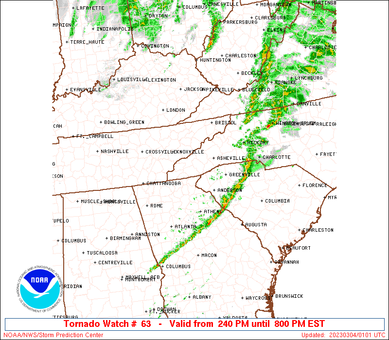
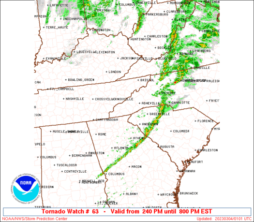
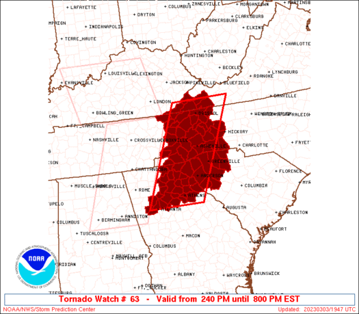
Tornado Watch Number 63
NWS Storm Prediction Center Norman OK
240 PM EST Fri Mar 3 2023
The NWS Storm Prediction Center has issued a
* Tornado Watch for portions of
North Georgia
Western North Carolina
Western South Carolina
Eastern Tennessee
Far southwest Virginia
* Effective this Friday afternoon and evening from 240 PM until
800 PM EST.
* Primary threats include...
A few tornadoes and a couple intense tornadoes possible
Scattered damaging winds likely with isolated significant gusts
to 75 mph possible
SUMMARY...A long-lived QLCS should continue to progress rapidly east
across the southern Appalachians vicinity through early evening.
Damaging winds and embedded tornadoes will be possible.
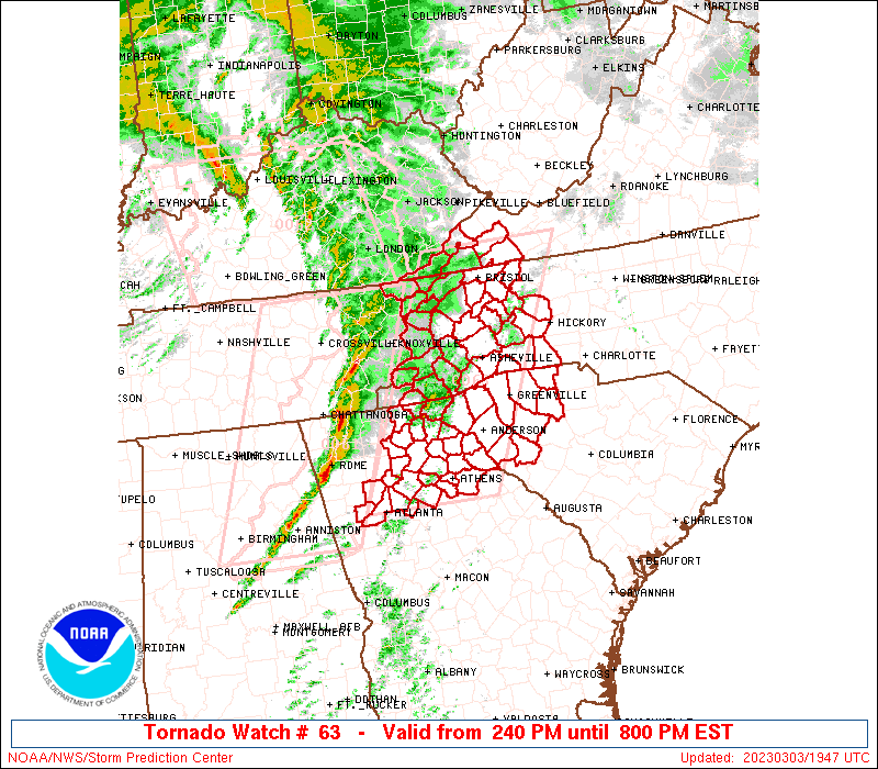
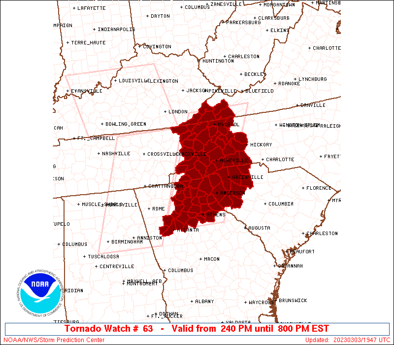
The tornado watch area is approximately along and 60 statute miles
east and west of a line from 35 miles north northeast of Bristol TN
to 30 miles southwest of Athens GA. For a complete depiction of the
watch see the associated watch outline update (WOUS64 KWNS WOU3).
PRECAUTIONARY/PREPAREDNESS ACTIONS...
REMEMBER...A Tornado Watch means conditions are favorable for
tornadoes and severe thunderstorms in and close to the watch
area. Persons in these areas should be on the lookout for
threatening weather conditions and listen for later statements
and possible warnings.
&&
OTHER WATCH INFORMATION...CONTINUE...WW 61...WW 62...
AVIATION...Tornadoes and a few severe thunderstorms with hail
surface and aloft to 1 inch. Extreme turbulence and surface wind
gusts to 65 knots. A few cumulonimbi with maximum tops to 450. Mean
storm motion vector 25050.
...Grams
 Note:
The Aviation Watch (SAW) product is an approximation to the watch area.
The actual watch is depicted by the shaded areas.
Note:
The Aviation Watch (SAW) product is an approximation to the watch area.
The actual watch is depicted by the shaded areas.
   SAW3
   WW 63 TORNADO GA NC SC TN VA 031940Z - 040100Z
   AXIS..60 STATUTE MILES EAST AND WEST OF LINE..
   35NNE TRI/BRISTOL TN/ - 30SW AHN/ATHENS GA/
   ..AVIATION COORDS.. 50NM E/W /30N HMV - 37E ATL/
   HAIL SURFACE AND ALOFT..1 INCH. WIND GUSTS..65 KNOTS.
   MAX TOPS TO 450. MEAN STORM MOTION VECTOR 25050.

   LAT...LON 36938107 33648266 33648474 36938324

   THIS IS AN APPROXIMATION TO THE WATCH AREA.  FOR A
   COMPLETE DEPICTION OF THE WATCH SEE WOUS64 KWNS
   FOR WOU3.
Watch 63 Status Report Messages:
STATUS REPORT #8 ON WW 63

VALID 040035Z - 040140Z

SEVERE WEATHER THREAT CONTINUES RIGHT OF A LINE FROM 30 E ATL TO
10 SSE AHN TO 5 E GSP TO 30 N HKY.

FOR ADDITIONAL INFORMATION SEE MESOSCALE DISCUSSION 253

..MOORE..03/04/23

ATTN...WFO...FFC...GSP...MRX...

&&

STATUS REPORT FOR WT 63

SEVERE WEATHER THREAT CONTINUES FOR THE FOLLOWING AREAS

GAC105-040140-

GA
.    GEORGIA COUNTIES INCLUDED ARE

ELBERT
$$


NCC023-045-040140-

NC
.    NORTH CAROLINA COUNTIES INCLUDED ARE

BURKE		     CLEVELAND
$$


SCC001-007-021-047-059-083-087-040140-

SC
.    SOUTH CAROLINA COUNTIES INCLUDED ARE

ABBEVILLE	     ANDERSON		 CHEROKEE
GREENWOOD	     LAURENS		 SPARTANBURG
UNION
$$


THE WATCH STATUS MESSAGE IS FOR GUIDANCE PURPOSES ONLY.  PLEASE
REFER TO WATCH COUNTY NOTIFICATION STATEMENTS FOR OFFICIAL
INFORMATION ON COUNTIES...INDEPENDENT CITIES AND MARINE ZONES
CLEARED FROM SEVERE THUNDERSTORM AND TORNADO WATCHES.
$$

STATUS REPORT #7 ON WW 63

VALID 032350Z - 040040Z

SEVERE WEATHER THREAT CONTINUES RIGHT OF A LINE FROM 35 E ATL TO
15 WSW GSP TO 25 N HKY.

..SPC..03/03/23

ATTN...WFO...FFC...GSP...MRX...

&&

STATUS REPORT FOR WT 63

SEVERE WEATHER THREAT CONTINUES FOR THE FOLLOWING AREAS

GAC059-105-147-195-219-221-040040-

GA
.    GEORGIA COUNTIES INCLUDED ARE

CLARKE		     ELBERT		 HART
MADISON 	     OCONEE		 OGLETHORPE
$$


NCC023-045-161-040040-

NC
.    NORTH CAROLINA COUNTIES INCLUDED ARE

BURKE		     CLEVELAND		 RUTHERFORD
$$


SCC001-007-021-045-047-059-083-087-040040-

SC
.    SOUTH CAROLINA COUNTIES INCLUDED ARE

ABBEVILLE	     ANDERSON		 CHEROKEE
GREENVILLE	     GREENWOOD		 LAURENS
SPARTANBURG	     UNION
$$


THE WATCH STATUS MESSAGE IS FOR GUIDANCE PURPOSES ONLY.  PLEASE
REFER TO WATCH COUNTY NOTIFICATION STATEMENTS FOR OFFICIAL
INFORMATION ON COUNTIES...INDEPENDENT CITIES AND MARINE ZONES
CLEARED FROM SEVERE THUNDERSTORM AND TORNADO WATCHES.
$$

STATUS REPORT #6 ON WW 63

VALID 032340Z - 040040Z

SEVERE WEATHER THREAT CONTINUES RIGHT OF A LINE FROM 10 SSE ATL
TO 25 WSW AND TO 15 NNW GSP TO 25 ENE AVL TO 45 NNE TRI.

FOR ADDITIONAL INFORMATION SEE MESOSCALE DISCUSSION 250

..MOORE..03/03/23

ATTN...WFO...FFC...GSP...MRX...

&&

STATUS REPORT FOR WT 63

SEVERE WEATHER THREAT CONTINUES FOR THE FOLLOWING AREAS

GAC059-105-147-195-219-221-040040-

GA
.    GEORGIA COUNTIES INCLUDED ARE

CLARKE		     ELBERT		 HART
MADISON 	     OCONEE		 OGLETHORPE
$$


NCC011-023-027-045-111-161-040040-

NC
.    NORTH CAROLINA COUNTIES INCLUDED ARE

AVERY		     BURKE		 CALDWELL
CLEVELAND	     MCDOWELL		 RUTHERFORD
$$


SCC001-007-021-045-047-059-083-087-040040-

SC
.    SOUTH CAROLINA COUNTIES INCLUDED ARE

ABBEVILLE	     ANDERSON		 CHEROKEE
GREENVILLE	     GREENWOOD		 LAURENS
SPARTANBURG	     UNION
$$


THE WATCH STATUS MESSAGE IS FOR GUIDANCE PURPOSES ONLY.  PLEASE
REFER TO WATCH COUNTY NOTIFICATION STATEMENTS FOR OFFICIAL
INFORMATION ON COUNTIES...INDEPENDENT CITIES AND MARINE ZONES
CLEARED FROM SEVERE THUNDERSTORM AND TORNADO WATCHES.
$$

STATUS REPORT #5 ON WW 63

VALID 032235Z - 032340Z

SEVERE WEATHER THREAT CONTINUES RIGHT OF A LINE FROM 30 W ATL TO
40 NW AND TO 10 ESE HSS TO 50 N TRI.

FOR ADDITIONAL INFORMATION SEE MESOSCALE DISCUSSION 249

..MOORE..03/03/23

ATTN...WFO...FFC...GSP...MRX...

&&

STATUS REPORT FOR WT 63

SEVERE WEATHER THREAT CONTINUES FOR THE FOLLOWING AREAS

GAC011-013-059-089-105-119-121-135-137-139-147-157-195-219-221-
247-257-297-032340-

GA
.    GEORGIA COUNTIES INCLUDED ARE

BANKS		     BARROW		 CLARKE
DEKALB		     ELBERT		 FRANKLIN
FULTON		     GWINNETT		 HABERSHAM
HALL		     HART		 JACKSON
MADISON 	     OCONEE		 OGLETHORPE
ROCKDALE	     STEPHENS		 WALTON
$$


NCC011-021-023-027-045-089-111-121-149-161-175-199-032340-

NC
.    NORTH CAROLINA COUNTIES INCLUDED ARE

AVERY		     BUNCOMBE		 BURKE
CALDWELL	     CLEVELAND		 HENDERSON
MCDOWELL	     MITCHELL		 POLK
RUTHERFORD	     TRANSYLVANIA	 YANCEY
$$


SCC001-007-021-045-047-059-073-077-083-087-032340-

SC
.    SOUTH CAROLINA COUNTIES INCLUDED ARE

ABBEVILLE	     ANDERSON		 CHEROKEE
GREENVILLE	     GREENWOOD		 LAURENS
OCONEE		     PICKENS		 SPARTANBURG
UNION
$$


TNC019-091-163-171-179-032340-

TN
.    TENNESSEE COUNTIES INCLUDED ARE

CARTER		     JOHNSON		 SULLIVAN
UNICOI		     WASHINGTON
$$


VAC167-191-520-032340-

VA
.    VIRGINIA COUNTIES INCLUDED ARE

RUSSELL 	     WASHINGTON


VIRGINIA INDEPENDENT CITIES INCLUDED ARE

BRISTOL
$$


THE WATCH STATUS MESSAGE IS FOR GUIDANCE PURPOSES ONLY.  PLEASE
REFER TO WATCH COUNTY NOTIFICATION STATEMENTS FOR OFFICIAL
INFORMATION ON COUNTIES...INDEPENDENT CITIES AND MARINE ZONES
CLEARED FROM SEVERE THUNDERSTORM AND TORNADO WATCHES.
$$

STATUS REPORT #4 ON WW 63

VALID 032235Z - 032340Z

SEVERE WEATHER THREAT CONTINUES RIGHT OF A LINE FROM 15 W ATL TO
45 NW AND TO 15 ENE HSS TO 35 NNE TRI.

..SPC..03/03/23

ATTN...WFO...FFC...GSP...MRX...

&&

STATUS REPORT FOR WT 63

SEVERE WEATHER THREAT CONTINUES FOR THE FOLLOWING AREAS

GAC011-013-059-089-105-119-121-135-137-139-147-157-195-219-221-
241-247-257-297-032340-

GA
.    GEORGIA COUNTIES INCLUDED ARE

BANKS		     BARROW		 CLARKE
DEKALB		     ELBERT		 FRANKLIN
FULTON		     GWINNETT		 HABERSHAM
HALL		     HART		 JACKSON
MADISON 	     OCONEE		 OGLETHORPE
RABUN		     ROCKDALE		 STEPHENS
WALTON
$$


NCC011-021-023-027-045-087-089-099-111-115-121-149-161-175-199-
032340-

NC
.    NORTH CAROLINA COUNTIES INCLUDED ARE

AVERY		     BUNCOMBE		 BURKE
CALDWELL	     CLEVELAND		 HAYWOOD
HENDERSON	     JACKSON		 MCDOWELL
MADISON 	     MITCHELL		 POLK
RUTHERFORD	     TRANSYLVANIA	 YANCEY
$$


SCC001-007-021-045-047-059-073-077-083-087-032340-

SC
.    SOUTH CAROLINA COUNTIES INCLUDED ARE

ABBEVILLE	     ANDERSON		 CHEROKEE
GREENVILLE	     GREENWOOD		 LAURENS
OCONEE		     PICKENS		 SPARTANBURG
UNION
$$


TNC019-091-163-171-179-032340-

TN
.    TENNESSEE COUNTIES INCLUDED ARE

CARTER		     JOHNSON		 SULLIVAN
UNICOI		     WASHINGTON
$$


VAC167-191-520-032340-

VA
.    VIRGINIA COUNTIES INCLUDED ARE

RUSSELL 	     WASHINGTON


VIRGINIA INDEPENDENT CITIES INCLUDED ARE

BRISTOL
$$


THE WATCH STATUS MESSAGE IS FOR GUIDANCE PURPOSES ONLY.  PLEASE
REFER TO WATCH COUNTY NOTIFICATION STATEMENTS FOR OFFICIAL
INFORMATION ON COUNTIES...INDEPENDENT CITIES AND MARINE ZONES
CLEARED FROM SEVERE THUNDERSTORM AND TORNADO WATCHES.
$$

STATUS REPORT #3 ON WW 63

VALID 032145Z - 032240Z

SEVERE WEATHER THREAT CONTINUES RIGHT OF A LINE FROM 35 E ANB TO
70 NNW AHN TO 35 E TYS TO 40 SE JKL.

..MOORE..03/03/23

ATTN...WFO...FFC...GSP...MRX...

&&

STATUS REPORT FOR WT 63

SEVERE WEATHER THREAT CONTINUES FOR THE FOLLOWING AREAS

GAC011-013-059-067-085-089-097-105-117-119-121-135-137-139-147-
157-187-195-219-221-241-247-257-281-297-311-032240-

GA
.    GEORGIA COUNTIES INCLUDED ARE

BANKS		     BARROW		 CLARKE
COBB		     DAWSON		 DEKALB
DOUGLAS 	     ELBERT		 FORSYTH
FRANKLIN	     FULTON		 GWINNETT
HABERSHAM	     HALL		 HART
JACKSON 	     LUMPKIN		 MADISON
OCONEE		     OGLETHORPE 	 RABUN
ROCKDALE	     STEPHENS		 TOWNS
WALTON		     WHITE
$$


NCC011-021-023-027-045-087-089-099-111-113-115-121-149-161-173-
175-199-032240-

NC
.    NORTH CAROLINA COUNTIES INCLUDED ARE

AVERY		     BUNCOMBE		 BURKE
CALDWELL	     CLEVELAND		 HAYWOOD
HENDERSON	     JACKSON		 MCDOWELL
MACON		     MADISON		 MITCHELL
POLK		     RUTHERFORD 	 SWAIN
TRANSYLVANIA	     YANCEY
$$


SCC001-007-021-045-047-059-073-077-083-087-032240-

SC
.    SOUTH CAROLINA COUNTIES INCLUDED ARE

ABBEVILLE	     ANDERSON		 CHEROKEE
GREENVILLE	     GREENWOOD		 LAURENS
OCONEE		     PICKENS		 SPARTANBURG
UNION
$$


TNC019-029-059-073-091-163-171-179-032240-

TN
.    TENNESSEE COUNTIES INCLUDED ARE

CARTER		     COCKE		 GREENE
HAWKINS 	     JOHNSON		 SULLIVAN
UNICOI		     WASHINGTON
$$


VAC167-169-191-195-520-720-032240-

VA
.    VIRGINIA COUNTIES INCLUDED ARE

RUSSELL 	     SCOTT		 WASHINGTON
WISE


VIRGINIA INDEPENDENT CITIES INCLUDED ARE

BRISTOL 	     NORTON
$$


THE WATCH STATUS MESSAGE IS FOR GUIDANCE PURPOSES ONLY.  PLEASE
REFER TO WATCH COUNTY NOTIFICATION STATEMENTS FOR OFFICIAL
INFORMATION ON COUNTIES...INDEPENDENT CITIES AND MARINE ZONES
CLEARED FROM SEVERE THUNDERSTORM AND TORNADO WATCHES.
$$

STATUS REPORT #2 ON WW 63

VALID 032115Z - 032240Z

SEVERE WEATHER THREAT CONTINUES RIGHT OF A LINE FROM 15 S RMG TO
25 E TYS TO 25 SE JKL.

..MOORE..03/03/23

ATTN...WFO...FFC...GSP...MRX...

&&

STATUS REPORT FOR WT 63

SEVERE WEATHER THREAT CONTINUES FOR THE FOLLOWING AREAS

GAC011-013-059-067-085-089-097-105-117-119-121-135-137-139-147-
157-187-195-219-221-241-247-257-281-291-297-311-032240-

GA
.    GEORGIA COUNTIES INCLUDED ARE

BANKS		     BARROW		 CLARKE
COBB		     DAWSON		 DEKALB
DOUGLAS 	     ELBERT		 FORSYTH
FRANKLIN	     FULTON		 GWINNETT
HABERSHAM	     HALL		 HART
JACKSON 	     LUMPKIN		 MADISON
OCONEE		     OGLETHORPE 	 RABUN
ROCKDALE	     STEPHENS		 TOWNS
UNION		     WALTON		 WHITE
$$


NCC011-021-023-027-043-045-075-087-089-099-111-113-115-121-149-
161-173-175-199-032240-

NC
.    NORTH CAROLINA COUNTIES INCLUDED ARE

AVERY		     BUNCOMBE		 BURKE
CALDWELL	     CLAY		 CLEVELAND
GRAHAM		     HAYWOOD		 HENDERSON
JACKSON 	     MCDOWELL		 MACON
MADISON 	     MITCHELL		 POLK
RUTHERFORD	     SWAIN		 TRANSYLVANIA
YANCEY
$$


SCC001-007-021-045-047-059-073-077-083-087-032240-

SC
.    SOUTH CAROLINA COUNTIES INCLUDED ARE

ABBEVILLE	     ANDERSON		 CHEROKEE
GREENVILLE	     GREENWOOD		 LAURENS
OCONEE		     PICKENS		 SPARTANBURG
UNION
$$


TNC019-029-059-063-067-073-091-163-171-179-032240-

TN
.    TENNESSEE COUNTIES INCLUDED ARE

CARTER		     COCKE		 GREENE
HAMBLEN 	     HANCOCK		 HAWKINS
JOHNSON 	     SULLIVAN		 UNICOI
WASHINGTON
$$


VAC105-167-169-191-195-520-720-032240-

VA
.    VIRGINIA COUNTIES INCLUDED ARE

LEE		     RUSSELL		 SCOTT
WASHINGTON	     WISE


VIRGINIA INDEPENDENT CITIES INCLUDED ARE

BRISTOL 	     NORTON
$$


THE WATCH STATUS MESSAGE IS FOR GUIDANCE PURPOSES ONLY.  PLEASE
REFER TO WATCH COUNTY NOTIFICATION STATEMENTS FOR OFFICIAL
INFORMATION ON COUNTIES...INDEPENDENT CITIES AND MARINE ZONES
CLEARED FROM SEVERE THUNDERSTORM AND TORNADO WATCHES.
$$

STATUS REPORT #1 ON WW 63

VALID 032045Z - 032140Z

THE SEVERE WEATHER THREAT CONTINUES ACROSS THE ENTIRE WATCH AREA.

..MOORE..03/03/23

ATTN...WFO...FFC...GSP...MRX...

&&

STATUS REPORT FOR WT 63

SEVERE WEATHER THREAT CONTINUES FOR THE FOLLOWING AREAS

GAC011-013-059-067-085-089-097-105-117-119-121-135-137-139-147-
157-187-195-219-221-241-247-257-281-291-297-311-032140-

GA
.    GEORGIA COUNTIES INCLUDED ARE

BANKS		     BARROW		 CLARKE
COBB		     DAWSON		 DEKALB
DOUGLAS 	     ELBERT		 FORSYTH
FRANKLIN	     FULTON		 GWINNETT
HABERSHAM	     HALL		 HART
JACKSON 	     LUMPKIN		 MADISON
OCONEE		     OGLETHORPE 	 RABUN
ROCKDALE	     STEPHENS		 TOWNS
UNION		     WALTON		 WHITE
$$


NCC011-021-023-027-043-045-075-087-089-099-111-113-115-121-149-
161-173-175-199-032140-

NC
.    NORTH CAROLINA COUNTIES INCLUDED ARE

AVERY		     BUNCOMBE		 BURKE
CALDWELL	     CLAY		 CLEVELAND
GRAHAM		     HAYWOOD		 HENDERSON
JACKSON 	     MCDOWELL		 MACON
MADISON 	     MITCHELL		 POLK
RUTHERFORD	     SWAIN		 TRANSYLVANIA
YANCEY
$$


SCC001-007-021-045-047-059-073-077-083-087-032140-

SC
.    SOUTH CAROLINA COUNTIES INCLUDED ARE

ABBEVILLE	     ANDERSON		 CHEROKEE
GREENVILLE	     GREENWOOD		 LAURENS
OCONEE		     PICKENS		 SPARTANBURG
UNION
$$


TNC019-025-029-057-059-063-067-073-089-091-155-163-171-179-
032140-

TN
.    TENNESSEE COUNTIES INCLUDED ARE

CARTER		     CLAIBORNE		 COCKE
GRAINGER	     GREENE		 HAMBLEN
HANCOCK 	     HAWKINS		 JEFFERSON
JOHNSON 	     SEVIER		 SULLIVAN
UNICOI		     WASHINGTON
$$


VAC105-167-169-191-195-520-720-032140-

VA
.    VIRGINIA COUNTIES INCLUDED ARE

LEE		     RUSSELL		 SCOTT
WASHINGTON	     WISE


VIRGINIA INDEPENDENT CITIES INCLUDED ARE

BRISTOL 	     NORTON
$$


THE WATCH STATUS MESSAGE IS FOR GUIDANCE PURPOSES ONLY.  PLEASE
REFER TO WATCH COUNTY NOTIFICATION STATEMENTS FOR OFFICIAL
INFORMATION ON COUNTIES...INDEPENDENT CITIES AND MARINE ZONES
CLEARED FROM SEVERE THUNDERSTORM AND TORNADO WATCHES.
$$
Note:
Click for Complete Product Text.
Tornadoes
Probability of 2 or more tornadoes
|
Mod (50%)
|
Probability of 1 or more strong (EF2-EF5) tornadoes
|
Mod (30%)
|
Wind
Probability of 10 or more severe wind events
|
Mod (60%)
|
Probability of 1 or more wind events > 65 knots
|
Mod (30%)
|
Hail
Probability of 10 or more severe hail events
|
Low (<5%)
|
Probability of 1 or more hailstones > 2 inches
|
Low (<5%)
|
Combined Severe Hail/Wind
Probability of 6 or more combined severe hail/wind events
|
High (70%)
|
For each watch, probabilities for particular events inside the watch
(listed above in each table) are determined by the issuing forecaster.
The "Low" category contains probability values ranging from less than 2%
to 20% (EF2-EF5 tornadoes), less than 5% to 20% (all other probabilities),
"Moderate" from 30% to 60%, and "High" from 70% to greater than 95%.
High values are bolded and lighter in color to provide awareness of
an increased threat for a particular event.


 @NWSSPC