 Note:
The expiration time in the watch graphic is amended if the watch is
replaced, cancelled or extended.
Note:
Note:
The expiration time in the watch graphic is amended if the watch is
replaced, cancelled or extended.
Note: Click for
Watch Status Reports.
SEL5
URGENT - IMMEDIATE BROADCAST REQUESTED
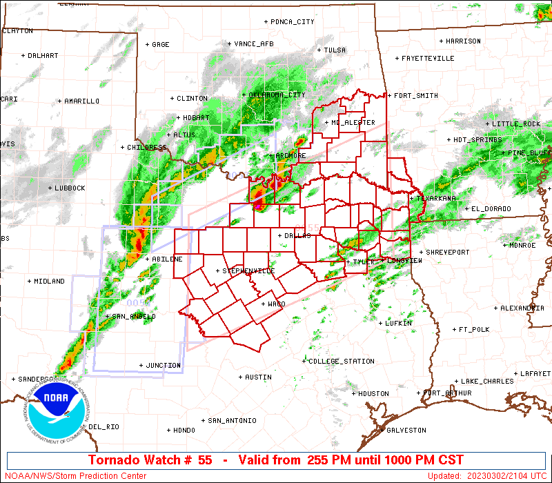
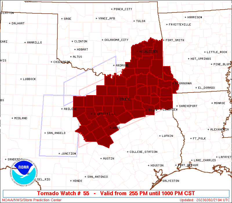
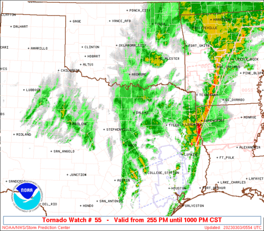
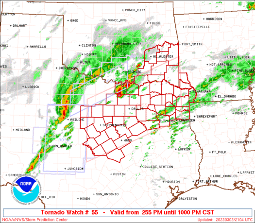
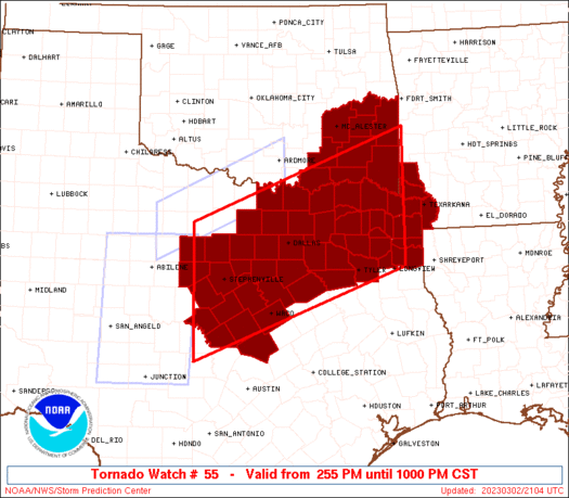
Tornado Watch Number 55
NWS Storm Prediction Center Norman OK
255 PM CST Thu Mar 2 2023
The NWS Storm Prediction Center has issued a
* Tornado Watch for portions of
Extreme southwest Arkansas
Southeast Oklahoma
North central and northeast Texas
* Effective this Thursday afternoon and evening from 255 PM until
1000 PM CST.
* Primary threats include...
A few tornadoes likely with a couple intense tornadoes possible
Scattered damaging winds and isolated significant gusts to 75
mph likely
Scattered large hail and isolated very large hail events to 3
inches in diameter likely
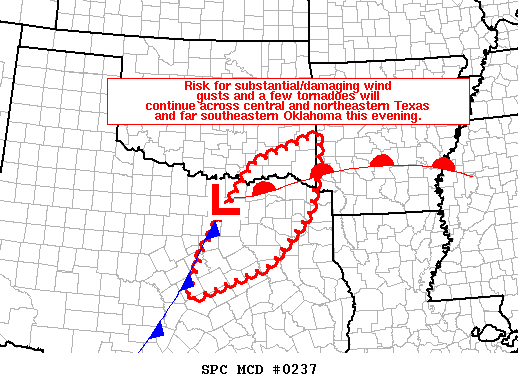
SUMMARY...Scattered supercells will move northeastward along a
stalled front from north Texas into southeast Oklahoma through late
evening, while additional storms form in the warm sector to the
south, and spread into north Texas from the west. The most
persistent/intense supercells will pose the threat for very large
hail up to 3 inches in diameter and a strong tornado or two.
Otherwise, upscale growth of the storms will favor an eventual
transition to the threat for damaging winds, some of which be near
or above 75 mph.
The tornado watch area is approximately along and 85 statute miles
north and south of a line from 60 miles east of Paris TX to 40 miles
west southwest of Stephenville TX. For a complete depiction of the
watch see the associated watch outline update (WOUS64 KWNS WOU5).
PRECAUTIONARY/PREPAREDNESS ACTIONS...
REMEMBER...A Tornado Watch means conditions are favorable for
tornadoes and severe thunderstorms in and close to the watch
area. Persons in these areas should be on the lookout for
threatening weather conditions and listen for later statements
and possible warnings.
&&
OTHER WATCH INFORMATION...CONTINUE...WW 53...WW 54...
AVIATION...Tornadoes and a few severe thunderstorms with hail
surface and aloft to 3 inches. Extreme turbulence and surface wind
gusts to 65 knots. A few cumulonimbi with maximum tops to 500. Mean
storm motion vector 24035.
...Thompson
   SEL5

   URGENT - IMMEDIATE BROADCAST REQUESTED
   Tornado Watch Number 55
   NWS Storm Prediction Center Norman OK
   255 PM CST Thu Mar 2 2023

   The NWS Storm Prediction Center has issued a

   * Tornado Watch for portions of
     Extreme southwest Arkansas
     Southeast Oklahoma
     North central and northeast Texas

   * Effective this Thursday afternoon and evening from 255 PM until
     1000 PM CST.

   * Primary threats include...
     A few tornadoes likely with a couple intense tornadoes possible
     Scattered damaging winds and isolated significant gusts to 75
       mph likely
     Scattered large hail and isolated very large hail events to 3
       inches in diameter likely

   SUMMARY...Scattered supercells will move northeastward along a
   stalled front from north Texas into southeast Oklahoma through late
   evening, while additional storms form in the warm sector to the
   south, and spread into north Texas from the west.  The most
   persistent/intense supercells will pose the threat for very large
   hail up to 3 inches in diameter and a strong tornado or two.
   Otherwise, upscale growth of the storms will favor an eventual
   transition to the threat for damaging winds, some of which be near
   or above 75 mph.

   The tornado watch area is approximately along and 85 statute miles
   north and south of a line from 60 miles east of Paris TX to 40 miles
   west southwest of Stephenville TX. For a complete depiction of the
   watch see the associated watch outline update (WOUS64 KWNS WOU5).

   PRECAUTIONARY/PREPAREDNESS ACTIONS...

   REMEMBER...A Tornado Watch means conditions are favorable for
   tornadoes and severe thunderstorms in and close to the watch
   area. Persons in these areas should be on the lookout for
   threatening weather conditions and listen for later statements
   and possible warnings.

   &&

   OTHER WATCH INFORMATION...CONTINUE...WW 53...WW 54...

   AVIATION...Tornadoes and a few severe thunderstorms with hail
   surface and aloft to 3 inches. Extreme turbulence and surface wind
   gusts to 65 knots. A few cumulonimbi with maximum tops to 500. Mean
   storm motion vector 24035.

   ...Thompson
 Note:
The Aviation Watch (SAW) product is an approximation to the watch area.
The actual watch is depicted by the shaded areas.
Note:
The Aviation Watch (SAW) product is an approximation to the watch area.
The actual watch is depicted by the shaded areas.
   SAW5
   WW 55 TORNADO AR OK TX 022055Z - 030400Z
   AXIS..85 STATUTE MILES NORTH AND SOUTH OF LINE..
   60E PRX/PARIS TX/ - 40WSW SEP/STEPHENVILLE TX/
   ..AVIATION COORDS.. 75NM N/S /18WNW TXK - 61ESE ABI/
   HAIL SURFACE AND ALOFT..3 INCHES. WIND GUSTS..65 KNOTS.
   MAX TOPS TO 500. MEAN STORM MOTION VECTOR 24035.

   LAT...LON 32409441 30779881 33239881 34869441

   THIS IS AN APPROXIMATION TO THE WATCH AREA.  FOR A
   COMPLETE DEPICTION OF THE WATCH SEE WOUS64 KWNS
   FOR WOU5.
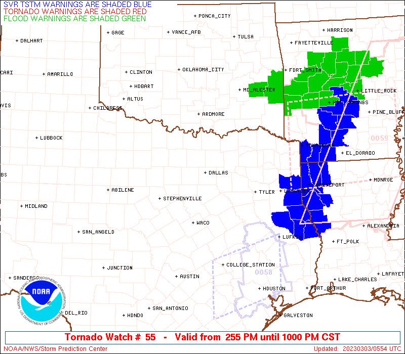
Watch 55 Status Report Messages:
STATUS REPORT #5 ON WW 55

VALID 030330Z - 030440Z

SEVERE WEATHER THREAT CONTINUES RIGHT OF A LINE FROM 25 NNE CLL
TO 45 SE CRS TO 35 SSW TYR TO 25 NE TYR TO 45 SE PRX TO 30 SSW
DEQ TO 15 WNW DEQ TO 10 S FSM.

..FLOURNOY..03/03/23

ATTN...WFO...SHV...OUN...TSA...FWD...

&&

STATUS REPORT FOR WT 55

SEVERE WEATHER THREAT CONTINUES FOR THE FOLLOWING AREAS

ARC081-091-133-030440-

AR
.    ARKANSAS COUNTIES INCLUDED ARE

LITTLE RIVER	     MILLER		 SEVIER
$$


OKC089-030440-

OK
.    OKLAHOMA COUNTIES INCLUDED ARE

MCCURTAIN
$$


TXC001-005-037-063-067-073-145-161-183-203-289-293-315-331-343-
347-365-395-401-403-405-419-423-459-030440-

TX
.    TEXAS COUNTIES INCLUDED ARE

ANDERSON	     ANGELINA		 BOWIE
CAMP		     CASS		 CHEROKEE
FALLS		     FREESTONE		 GREGG
HARRISON	     LEON		 LIMESTONE
MARION		     MILAM		 MORRIS
NACOGDOCHES	     PANOLA		 ROBERTSON
RUSK		     SABINE		 SAN AUGUSTINE
SHELBY		     SMITH		 UPSHUR
$$


THE WATCH STATUS MESSAGE IS FOR GUIDANCE PURPOSES ONLY.  PLEASE
REFER TO WATCH COUNTY NOTIFICATION STATEMENTS FOR OFFICIAL
INFORMATION ON COUNTIES...INDEPENDENT CITIES AND MARINE ZONES
CLEARED FROM SEVERE THUNDERSTORM AND TORNADO WATCHES.
$$

STATUS REPORT #4 ON WW 55

VALID 030230Z - 030340Z

SEVERE WEATHER THREAT CONTINUES RIGHT OF A LINE FROM 30 ENE AUS
TO 30 ESE TPL TO 25 ESE ACT TO 20 SSW CRS TO 30 NNE CRS TO 40 NNW
TYR TO 10 SE PRX TO 20 NNE PRX TO 40 WNW DEQ TO 25 WSW RKR TO 30
ESE MKO.

..FLOURNOY..03/03/23

ATTN...WFO...SHV...OUN...TSA...FWD...

&&

STATUS REPORT FOR WT 55

SEVERE WEATHER THREAT CONTINUES FOR THE FOLLOWING AREAS

ARC081-091-133-030340-

AR
.    ARKANSAS COUNTIES INCLUDED ARE

LITTLE RIVER	     MILLER		 SEVIER
$$


OKC079-089-030340-

OK
.    OKLAHOMA COUNTIES INCLUDED ARE

LE FLORE	     MCCURTAIN
$$


TXC001-005-037-063-067-073-145-159-161-183-203-213-223-289-293-
315-331-343-347-349-365-387-395-401-403-405-419-423-449-459-467-
499-030340-

TX
.    TEXAS COUNTIES INCLUDED ARE

ANDERSON	     ANGELINA		 BOWIE
CAMP		     CASS		 CHEROKEE
FALLS		     FRANKLIN		 FREESTONE
GREGG		     HARRISON		 HENDERSON
HOPKINS 	     LEON		 LIMESTONE
MARION		     MILAM		 MORRIS
NACOGDOCHES	     NAVARRO		 PANOLA
RED RIVER	     ROBERTSON		 RUSK
SABINE		     SAN AUGUSTINE	 SHELBY
SMITH		     TITUS		 UPSHUR
VAN ZANDT	     WOOD
$$


THE WATCH STATUS MESSAGE IS FOR GUIDANCE PURPOSES ONLY.  PLEASE
REFER TO WATCH COUNTY NOTIFICATION STATEMENTS FOR OFFICIAL
INFORMATION ON COUNTIES...INDEPENDENT CITIES AND MARINE ZONES
CLEARED FROM SEVERE THUNDERSTORM AND TORNADO WATCHES.
$$

STATUS REPORT #3 ON WW 55

VALID 030125Z - 030240Z

SEVERE WEATHER THREAT CONTINUES RIGHT OF A LINE FROM 10 SW TPL TO
5 NNW ACT TO 25 SSE DAL TO 25 E DAL TO 35 ESE GYI TO 40 N PRX TO
25 SE MLC.

FOR ADDITIONAL INFORMATION SEE MESOSCALE DISCUSSION 237

..FLOURNOY..03/03/23

ATTN...WFO...SHV...OUN...TSA...FWD...

&&

STATUS REPORT FOR WT 55

SEVERE WEATHER THREAT CONTINUES FOR THE FOLLOWING AREAS

ARC081-091-133-030240-

AR
.    ARKANSAS COUNTIES INCLUDED ARE

LITTLE RIVER	     MILLER		 SEVIER
$$


OKC023-061-077-079-089-127-030240-

OK
.    OKLAHOMA COUNTIES INCLUDED ARE

CHOCTAW 	     HASKELL		 LATIMER
LE FLORE	     MCCURTAIN		 PUSHMATAHA
$$


TXC001-027-037-063-067-119-139-145-147-159-161-183-203-213-217-
223-231-257-277-289-293-309-315-331-343-349-379-387-395-397-423-
449-459-467-499-030240-

TX
.    TEXAS COUNTIES INCLUDED ARE

ANDERSON	     BELL		 BOWIE
CAMP		     CASS		 DELTA
ELLIS		     FALLS		 FANNIN
FRANKLIN	     FREESTONE		 GREGG
HARRISON	     HENDERSON		 HILL
HOPKINS 	     HUNT		 KAUFMAN
LAMAR		     LEON		 LIMESTONE
MCLENNAN	     MARION		 MILAM
MORRIS		     NAVARRO		 RAINS
RED RIVER	     ROBERTSON		 ROCKWALL
SMITH		     TITUS		 UPSHUR
VAN ZANDT	     WOOD
$$


THE WATCH STATUS MESSAGE IS FOR GUIDANCE PURPOSES ONLY.  PLEASE
REFER TO WATCH COUNTY NOTIFICATION STATEMENTS FOR OFFICIAL
INFORMATION ON COUNTIES...INDEPENDENT CITIES AND MARINE ZONES
CLEARED FROM SEVERE THUNDERSTORM AND TORNADO WATCHES.
$$

STATUS REPORT #2 ON WW 55

VALID 030030Z - 030140Z

SEVERE WEATHER THREAT CONTINUES RIGHT OF A LINE FROM 55 NW AUS TO
50 WNW TPL TO 25 E SEP TO 20 S FTW TO 20 SSW GYI TO 5 SE DUA TO
30 SSW MLC.

FOR ADDITIONAL INFORMATION SEE MESOSCALE DISCUSSION 233

..FLOURNOY..03/03/23

ATTN...WFO...SHV...OUN...TSA...FWD...

&&

STATUS REPORT FOR WT 55

SEVERE WEATHER THREAT CONTINUES FOR THE FOLLOWING AREAS

ARC081-091-133-030140-

AR
.    ARKANSAS COUNTIES INCLUDED ARE

LITTLE RIVER	     MILLER		 SEVIER
$$


OKC005-013-023-061-077-079-089-121-127-030140-

OK
.    OKLAHOMA COUNTIES INCLUDED ARE

ATOKA		     BRYAN		 CHOCTAW
HASKELL 	     LATIMER		 LE FLORE
MCCURTAIN	     PITTSBURG		 PUSHMATAHA
$$


TXC027-035-037-063-067-085-099-113-119-121-139-147-159-181-183-
193-203-213-217-223-231-251-257-277-281-309-315-343-349-379-387-
397-423-439-449-459-467-499-030140-

TX
.    TEXAS COUNTIES INCLUDED ARE

BELL		     BOSQUE		 BOWIE
CAMP		     CASS		 COLLIN
CORYELL 	     DALLAS		 DELTA
DENTON		     ELLIS		 FANNIN
FRANKLIN	     GRAYSON		 GREGG
HAMILTON	     HARRISON		 HENDERSON
HILL		     HOPKINS		 HUNT
JOHNSON 	     KAUFMAN		 LAMAR
LAMPASAS	     MCLENNAN		 MARION
MORRIS		     NAVARRO		 RAINS
RED RIVER	     ROCKWALL		 SMITH
TARRANT 	     TITUS		 UPSHUR
VAN ZANDT	     WOOD
$$


THE WATCH STATUS MESSAGE IS FOR GUIDANCE PURPOSES ONLY.  PLEASE
REFER TO WATCH COUNTY NOTIFICATION STATEMENTS FOR OFFICIAL
INFORMATION ON COUNTIES...INDEPENDENT CITIES AND MARINE ZONES
CLEARED FROM SEVERE THUNDERSTORM AND TORNADO WATCHES.
$$

STATUS REPORT #1 ON WW 55

VALID 022140Z - 022240Z

THE SEVERE WEATHER THREAT CONTINUES ACROSS THE ENTIRE WATCH AREA.

FOR ADDITIONAL INFORMATION SEE MESOSCALE DISCUSSION 230

..THORNTON..03/02/23

ATTN...WFO...SHV...OUN...TSA...FWD...

&&

STATUS REPORT FOR WT 55

SEVERE WEATHER THREAT CONTINUES FOR THE FOLLOWING AREAS

ARC081-091-133-022240-

AR
.    ARKANSAS COUNTIES INCLUDED ARE

LITTLE RIVER	     MILLER		 SEVIER
$$


OKC005-013-023-061-077-079-089-121-127-022240-

OK
.    OKLAHOMA COUNTIES INCLUDED ARE

ATOKA		     BRYAN		 CHOCTAW
HASKELL 	     LATIMER		 LE FLORE
MCCURTAIN	     PITTSBURG		 PUSHMATAHA
$$


TXC027-035-037-063-067-085-093-097-099-113-119-121-133-139-143-
147-159-181-183-193-203-213-217-221-223-231-251-257-277-281-309-
315-333-343-349-363-367-379-387-397-423-425-429-439-449-459-467-
497-499-022240-

TX
.    TEXAS COUNTIES INCLUDED ARE

BELL		     BOSQUE		 BOWIE
CAMP		     CASS		 COLLIN
COMANCHE	     COOKE		 CORYELL
DALLAS		     DELTA		 DENTON
EASTLAND	     ELLIS		 ERATH
FANNIN		     FRANKLIN		 GRAYSON
GREGG		     HAMILTON		 HARRISON
HENDERSON	     HILL		 HOOD
HOPKINS 	     HUNT		 JOHNSON
KAUFMAN 	     LAMAR		 LAMPASAS
MCLENNAN	     MARION		 MILLS
MORRIS		     NAVARRO		 PALO PINTO
PARKER		     RAINS		 RED RIVER
ROCKWALL	     SMITH		 SOMERVELL
STEPHENS	     TARRANT		 TITUS
UPSHUR		     VAN ZANDT		 WISE
WOOD
$$


THE WATCH STATUS MESSAGE IS FOR GUIDANCE PURPOSES ONLY.  PLEASE
REFER TO WATCH COUNTY NOTIFICATION STATEMENTS FOR OFFICIAL
INFORMATION ON COUNTIES...INDEPENDENT CITIES AND MARINE ZONES
CLEARED FROM SEVERE THUNDERSTORM AND TORNADO WATCHES.
$$
Note:
Click for Complete Product Text.
Tornadoes
Probability of 2 or more tornadoes
|
High (70%)
|
Probability of 1 or more strong (EF2-EF5) tornadoes
|
Mod (30%)
|
Wind
Probability of 10 or more severe wind events
|
High (70%)
|
Probability of 1 or more wind events > 65 knots
|
Mod (60%)
|
Hail
Probability of 10 or more severe hail events
|
High (70%)
|
Probability of 1 or more hailstones > 2 inches
|
High (70%)
|
Combined Severe Hail/Wind
Probability of 6 or more combined severe hail/wind events
|
High (>95%)
|
For each watch, probabilities for particular events inside the watch
(listed above in each table) are determined by the issuing forecaster.
The "Low" category contains probability values ranging from less than 2%
to 20% (EF2-EF5 tornadoes), less than 5% to 20% (all other probabilities),
"Moderate" from 30% to 60%, and "High" from 70% to greater than 95%.
High values are bolded and lighter in color to provide awareness of
an increased threat for a particular event.


 @NWSSPC