|
| Mesoscale Discussion 237 |
|
< Previous MD Next MD >
|
|
Mesoscale Discussion 0237
NWS Storm Prediction Center Norman OK
0713 PM CST Thu Mar 02 2023
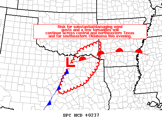
Areas affected...southeastern Oklahoma southwestward into central
Texas
Concerning...Tornado Watch 55...
Valid 030113Z - 030245Z
The severe weather threat for Tornado Watch 55 continues.
SUMMARY...Risk for locally substantial damaging wind gusts and a few
tornadoes will continue across the watch area.
DISCUSSION...Latest radar loop shows a well-organized line of
strong/severe storms extending from southeastern Oklahoma
south-southwestward across the Texas Hill County. With a very
strong upper-level system centered near the southeastern New
Mexico/Texas border, intense downstream flow aloft has contributed
to numerous damaging wind gusts across northern and central Texas
over the past hour or so -- including several measured gusts over 70
mph. As the line of storms continues moving eastward at around 40
kt through northern and central Texas, potential for
local/substantial wind gusts will continue. In addition, risk for
occasional tornadoes within the intense convective band will also
continue -- which would heighten local risk for damage with these
storms.
..Goss.. 03/03/2023
...Please see www.spc.noaa.gov for graphic product...
ATTN...WFO...LZK...SHV...TSA...FWD...OUN...
LAT...LON 31259780 32179749 34199618 34859440 33819451 33059471
31949570 31139779 31259780
|
|
Top/All Mesoscale Discussions/Forecast Products/Home
|
|


 @NWSSPC