Note:
The expiration time in the watch graphic is amended if the watch is
replaced, cancelled or extended.
Note:
Note:
The expiration time in the watch graphic is amended if the watch is
replaced, cancelled or extended.
Note: Click for
Watch Status Reports.
SEL3
URGENT - IMMEDIATE BROADCAST REQUESTED
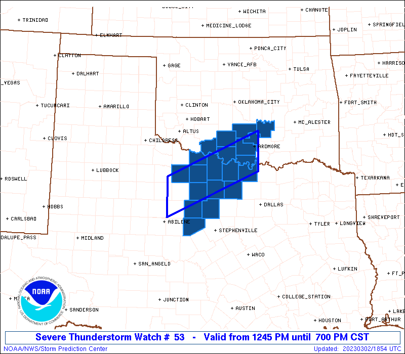
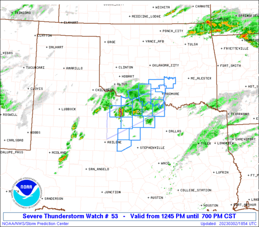
Severe Thunderstorm Watch Number 53
NWS Storm Prediction Center Norman OK
1245 PM CST Thu Mar 2 2023
The NWS Storm Prediction Center has issued a
* Severe Thunderstorm Watch for portions of
Southern Oklahoma
Western north Texas
* Effective this Thursday afternoon and evening from 1245 PM
until 700 PM CST.
* Primary threats include...
Scattered large hail and isolated very large hail events to 3
inches in diameter likely
Scattered damaging winds and isolated significant gusts to 75
mph possible
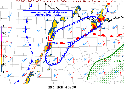
SUMMARY...Initially elevated thunderstorms will evolve into more
surface-based storms along a front from northwest Texas into
southern Oklahoma this afternoon. The storm environment will favor
clusters of supercells capable of producing swaths of very large
hail up to 3 inches in diameter, and occasional damaging gusts of
60-75 mph.
The severe thunderstorm watch area is approximately along and 35
statute miles north and south of a line from 10 miles southeast of
Ardmore OK to 90 miles southwest of Wichita Falls TX. For a complete
depiction of the watch see the associated watch outline update
(WOUS64 KWNS WOU3).
PRECAUTIONARY/PREPAREDNESS ACTIONS...
REMEMBER...A Severe Thunderstorm Watch means conditions are
favorable for severe thunderstorms in and close to the watch area.
Persons in these areas should be on the lookout for threatening
weather conditions and listen for later statements and possible
warnings. Severe thunderstorms can and occasionally do produce
tornadoes.
&&
AVIATION...A few severe thunderstorms with hail surface and aloft to
3 inches. Extreme turbulence and surface wind gusts to 65 knots. A
few cumulonimbi with maximum tops to 500. Mean storm motion vector
24035.
...Thompson
   SEL3

   URGENT - IMMEDIATE BROADCAST REQUESTED
   Severe Thunderstorm Watch Number 53
   NWS Storm Prediction Center Norman OK
   1245 PM CST Thu Mar 2 2023

   The NWS Storm Prediction Center has issued a

   * Severe Thunderstorm Watch for portions of
     Southern Oklahoma
     Western north Texas

   * Effective this Thursday afternoon and evening from 1245 PM
     until 700 PM CST.

   * Primary threats include...
     Scattered large hail and isolated very large hail events to 3
       inches in diameter likely
     Scattered damaging winds and isolated significant gusts to 75
       mph possible

   SUMMARY...Initially elevated thunderstorms will evolve into more
   surface-based storms along a front from northwest Texas into
   southern Oklahoma this afternoon.  The storm environment will favor
   clusters of supercells capable of producing swaths of very large
   hail up to 3 inches in diameter, and occasional damaging gusts of
   60-75 mph.

   The severe thunderstorm watch area is approximately along and 35
   statute miles north and south of a line from 10 miles southeast of
   Ardmore OK to 90 miles southwest of Wichita Falls TX. For a complete
   depiction of the watch see the associated watch outline update
   (WOUS64 KWNS WOU3).

   PRECAUTIONARY/PREPAREDNESS ACTIONS...

   REMEMBER...A Severe Thunderstorm Watch means conditions are
   favorable for severe thunderstorms in and close to the watch area.
   Persons in these areas should be on the lookout for threatening
   weather conditions and listen for later statements and possible
   warnings. Severe thunderstorms can and occasionally do produce
   tornadoes.

   &&

   AVIATION...A few severe thunderstorms with hail surface and aloft to
   3 inches. Extreme turbulence and surface wind gusts to 65 knots. A
   few cumulonimbi with maximum tops to 500. Mean storm motion vector
   24035.

   ...Thompson
 Note:
The Aviation Watch (SAW) product is an approximation to the watch area.
The actual watch is depicted by the shaded areas.
Note:
The Aviation Watch (SAW) product is an approximation to the watch area.
The actual watch is depicted by the shaded areas.
   SAW3
   WW 53 SEVERE TSTM OK TX 021845Z - 030100Z
   AXIS..35 STATUTE MILES NORTH AND SOUTH OF LINE..
   10SE ADM/ARDMORE OK/ - 90SW SPS/WICHITA FALLS TX/
   ..AVIATION COORDS.. 30NM N/S /14E ADM - 36NNE ABI/
   HAIL SURFACE AND ALOFT..3 INCHES. WIND GUSTS..65 KNOTS.
   MAX TOPS TO 500. MEAN STORM MOTION VECTOR 24035.

   LAT...LON 33689690 32549960 33559960 34689690

   THIS IS AN APPROXIMATION TO THE WATCH AREA.  FOR A
   COMPLETE DEPICTION OF THE WATCH SEE WOUS64 KWNS
   FOR WOU3.
Watch 53 Status Report Messages:
STATUS REPORT #5 ON WW 53

VALID 022330Z - 030040Z

SEVERE WEATHER THREAT CONTINUES RIGHT OF A LINE FROM 35 NNW FTW
TO 25 SSW ADM TO 35 N ADM.

..FLOURNOY..03/02/23

ATTN...WFO...OUN...FWD...

&&

STATUS REPORT FOR WS 53

SEVERE WEATHER THREAT CONTINUES FOR THE FOLLOWING AREAS

OKC019-029-069-085-095-099-123-030040-

OK
.    OKLAHOMA COUNTIES INCLUDED ARE

CARTER		     COAL		 JOHNSTON
LOVE		     MARSHALL		 MURRAY
PONTOTOC
$$


THE WATCH STATUS MESSAGE IS FOR GUIDANCE PURPOSES ONLY.  PLEASE
REFER TO WATCH COUNTY NOTIFICATION STATEMENTS FOR OFFICIAL
INFORMATION ON COUNTIES...INDEPENDENT CITIES AND MARINE ZONES
CLEARED FROM SEVERE THUNDERSTORM AND TORNADO WATCHES.
$$

STATUS REPORT #4 ON WW 53

VALID 022235Z - 022340Z

SEVERE WEATHER THREAT CONTINUES RIGHT OF A LINE FROM 35 W MWL TO
30 S SPS TO 30 SE FSI.

FOR ADDITIONAL INFORMATION SEE MESOSCALE DISCUSSION 230

..FLOURNOY..03/02/23

ATTN...WFO...OUN...FWD...

&&

STATUS REPORT FOR WS 53

SEVERE WEATHER THREAT CONTINUES FOR THE FOLLOWING AREAS

OKC019-029-049-067-069-085-095-099-123-137-022340-

OK
.    OKLAHOMA COUNTIES INCLUDED ARE

CARTER		     COAL		 GARVIN
JEFFERSON	     JOHNSTON		 LOVE
MARSHALL	     MURRAY		 PONTOTOC
STEPHENS
$$


TXC077-237-337-022340-

TX
.    TEXAS COUNTIES INCLUDED ARE

CLAY		     JACK		 MONTAGUE
$$


THE WATCH STATUS MESSAGE IS FOR GUIDANCE PURPOSES ONLY.  PLEASE
REFER TO WATCH COUNTY NOTIFICATION STATEMENTS FOR OFFICIAL
INFORMATION ON COUNTIES...INDEPENDENT CITIES AND MARINE ZONES
CLEARED FROM SEVERE THUNDERSTORM AND TORNADO WATCHES.
$$

STATUS REPORT #3 ON WW 53

VALID 022135Z - 022240Z

SEVERE WEATHER THREAT CONTINUES RIGHT OF A LINE FROM 55 NW ABI TO
25 NNW SPS.

FOR ADDITIONAL INFORMATION SEE MESOSCALE DISCUSSION 229

..THORNTON..03/02/23

ATTN...WFO...OUN...FWD...

&&

STATUS REPORT FOR WS 53

SEVERE WEATHER THREAT CONTINUES FOR THE FOLLOWING AREAS

OKC019-029-033-049-067-069-085-095-099-123-137-022240-

OK
.    OKLAHOMA COUNTIES INCLUDED ARE

CARTER		     COAL		 COTTON
GARVIN		     JEFFERSON		 JOHNSTON
LOVE		     MARSHALL		 MURRAY
PONTOTOC	     STEPHENS
$$


TXC009-023-077-237-337-485-503-022240-

TX
.    TEXAS COUNTIES INCLUDED ARE

ARCHER		     BAYLOR		 CLAY
JACK		     MONTAGUE		 WICHITA
YOUNG
$$


THE WATCH STATUS MESSAGE IS FOR GUIDANCE PURPOSES ONLY.  PLEASE
REFER TO WATCH COUNTY NOTIFICATION STATEMENTS FOR OFFICIAL
INFORMATION ON COUNTIES...INDEPENDENT CITIES AND MARINE ZONES
CLEARED FROM SEVERE THUNDERSTORM AND TORNADO WATCHES.
$$

STATUS REPORT #2 ON WW 53

VALID 022035Z - 022140Z

THE SEVERE WEATHER THREAT CONTINUES ACROSS THE ENTIRE WATCH AREA.

..THORNTON..03/02/23

ATTN...WFO...OUN...FWD...

&&

STATUS REPORT FOR WS 53

SEVERE WEATHER THREAT CONTINUES FOR THE FOLLOWING AREAS

OKC019-033-049-067-085-099-123-137-022140-

OK
.    OKLAHOMA COUNTIES INCLUDED ARE

CARTER		     COTTON		 GARVIN
JEFFERSON	     LOVE		 MURRAY
PONTOTOC	     STEPHENS
$$


TXC009-023-077-097-133-237-337-363-429-485-497-503-022140-

TX
.    TEXAS COUNTIES INCLUDED ARE

ARCHER		     BAYLOR		 CLAY
COOKE		     EASTLAND		 JACK
MONTAGUE	     PALO PINTO 	 STEPHENS
WICHITA 	     WISE		 YOUNG
$$


THE WATCH STATUS MESSAGE IS FOR GUIDANCE PURPOSES ONLY.  PLEASE
REFER TO WATCH COUNTY NOTIFICATION STATEMENTS FOR OFFICIAL
INFORMATION ON COUNTIES...INDEPENDENT CITIES AND MARINE ZONES
CLEARED FROM SEVERE THUNDERSTORM AND TORNADO WATCHES.
$$

STATUS REPORT #1 ON WW 53

VALID 021935Z - 022040Z

THE SEVERE WEATHER THREAT CONTINUES ACROSS THE ENTIRE WATCH AREA.

FOR ADDITIONAL INFORMATION SEE MESOSCALE DISCUSSION 226

..THORNTON..03/02/23

ATTN...WFO...OUN...FWD...

&&

STATUS REPORT FOR WS 53

SEVERE WEATHER THREAT CONTINUES FOR THE FOLLOWING AREAS

OKC019-033-049-067-085-099-123-137-022040-

OK
.    OKLAHOMA COUNTIES INCLUDED ARE

CARTER		     COTTON		 GARVIN
JEFFERSON	     LOVE		 MURRAY
PONTOTOC	     STEPHENS
$$


TXC009-023-077-097-133-237-337-363-429-485-497-503-022040-

TX
.    TEXAS COUNTIES INCLUDED ARE

ARCHER		     BAYLOR		 CLAY
COOKE		     EASTLAND		 JACK
MONTAGUE	     PALO PINTO 	 STEPHENS
WICHITA 	     WISE		 YOUNG
$$


THE WATCH STATUS MESSAGE IS FOR GUIDANCE PURPOSES ONLY.  PLEASE
REFER TO WATCH COUNTY NOTIFICATION STATEMENTS FOR OFFICIAL
INFORMATION ON COUNTIES...INDEPENDENT CITIES AND MARINE ZONES
CLEARED FROM SEVERE THUNDERSTORM AND TORNADO WATCHES.
$$
Note:
Click for Complete Product Text.
Tornadoes
Probability of 2 or more tornadoes
|
Low (10%)
|
Probability of 1 or more strong (EF2-EF5) tornadoes
|
Low (5%)
|
Wind
Probability of 10 or more severe wind events
|
Mod (50%)
|
Probability of 1 or more wind events > 65 knots
|
Mod (40%)
|
Hail
Probability of 10 or more severe hail events
|
High (70%)
|
Probability of 1 or more hailstones > 2 inches
|
High (70%)
|
Combined Severe Hail/Wind
Probability of 6 or more combined severe hail/wind events
|
High (>95%)
|
For each watch, probabilities for particular events inside the watch
(listed above in each table) are determined by the issuing forecaster.
The "Low" category contains probability values ranging from less than 2%
to 20% (EF2-EF5 tornadoes), less than 5% to 20% (all other probabilities),
"Moderate" from 30% to 60%, and "High" from 70% to greater than 95%.
High values are bolded and lighter in color to provide awareness of
an increased threat for a particular event.


 @NWSSPC