Note:
The expiration time in the watch graphic is amended if the watch is
replaced, cancelled or extended.
Note:
Note:
The expiration time in the watch graphic is amended if the watch is
replaced, cancelled or extended.
Note: Click for
Watch Status Reports.
SEL9
URGENT - IMMEDIATE BROADCAST REQUESTED
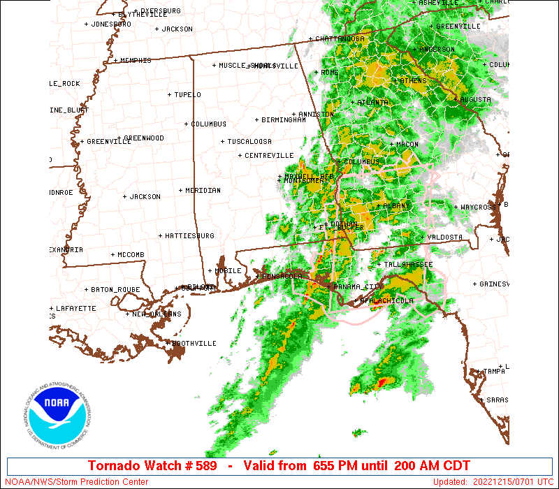
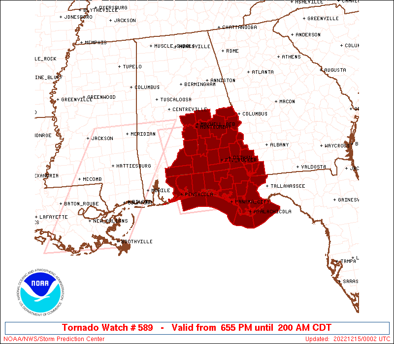
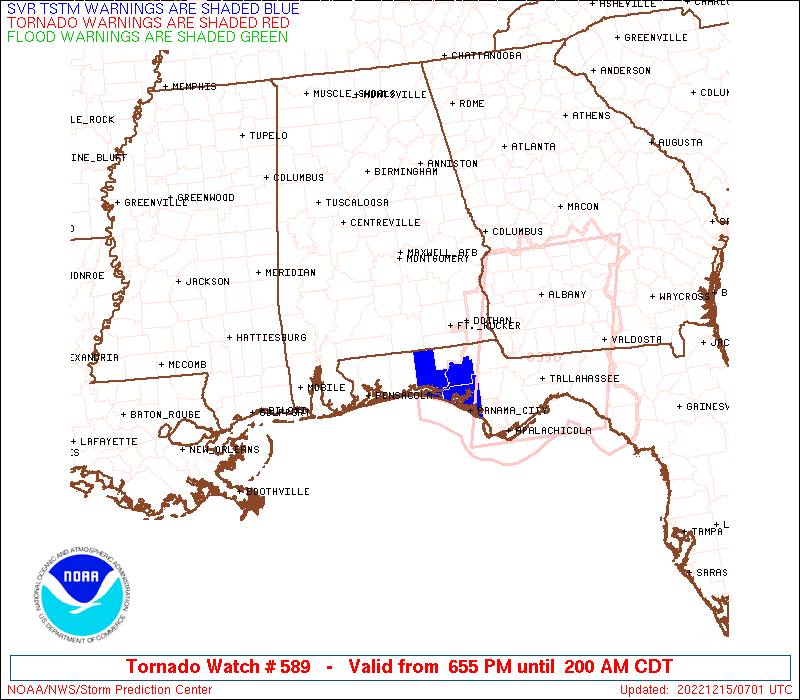
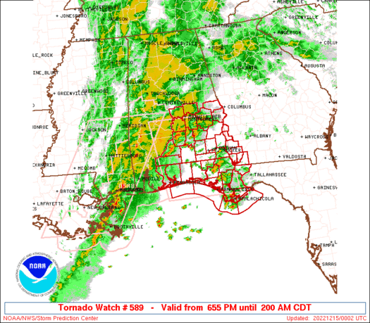
Tornado Watch Number 589
NWS Storm Prediction Center Norman OK
555 PM CST Wed Dec 14 2022
The NWS Storm Prediction Center has issued a
* Tornado Watch for portions of
Southern Alabama
Florida Panhandle
Southwest Georgia
Coastal Waters
* Effective this Wednesday night and Thursday morning from 555 PM
until 100 AM CST.
* Primary threats include...
Several tornadoes likely with a couple intense tornadoes
possible
Scattered damaging wind gusts to 65 mph possible
SUMMARY...Tornado potential is expected to increase across the
region as bands of semi-discrete/cluster supercells move
east-northeastward into the region, while additional storms develop
within the increasingly moist warm sector and near the
northwest/southeast-oriented warm front. Strengthening
deep-layer/low-level winds will support tornado potential, including
the possibility of strong/intense tornadoes (EF2+).
The tornado watch area is approximately along and 75 statute miles
east and west of a line from 5 miles north northwest of Montgomery
AL to 30 miles southwest of Panama City FL. For a complete depiction
of the watch see the associated watch outline update (WOUS64 KWNS
WOU9).
PRECAUTIONARY/PREPAREDNESS ACTIONS...
REMEMBER...A Tornado Watch means conditions are favorable for
tornadoes and severe thunderstorms in and close to the watch
area. Persons in these areas should be on the lookout for
threatening weather conditions and listen for later statements
and possible warnings.
&&
OTHER WATCH INFORMATION...CONTINUE...WW 588...
AVIATION...Tornadoes and a few severe thunderstorms with hail
surface and aloft to 1 inch. Extreme turbulence and surface wind
gusts to 55 knots. A few cumulonimbi with maximum tops to 450. Mean
storm motion vector 22035.
...Guyer
   SEL9

   URGENT - IMMEDIATE BROADCAST REQUESTED
   Tornado Watch Number 589
   NWS Storm Prediction Center Norman OK
   555 PM CST Wed Dec 14 2022

   The NWS Storm Prediction Center has issued a

   * Tornado Watch for portions of
     Southern Alabama
     Florida Panhandle
     Southwest Georgia
     Coastal Waters

   * Effective this Wednesday night and Thursday morning from 555 PM
     until 100 AM CST.

   * Primary threats include...
     Several tornadoes likely with a couple intense tornadoes
       possible
     Scattered damaging wind gusts to 65 mph possible

   SUMMARY...Tornado potential is expected to increase across the
   region as bands of semi-discrete/cluster supercells move
   east-northeastward into the region, while additional storms develop
   within the increasingly moist warm sector and near the
   northwest/southeast-oriented warm front. Strengthening
   deep-layer/low-level winds will support tornado potential, including

   the possibility of strong/intense tornadoes (EF2+).

   The tornado watch area is approximately along and 75 statute miles
   east and west of a line from 5 miles north northwest of Montgomery
   AL to 30 miles southwest of Panama City FL. For a complete depiction
   of the watch see the associated watch outline update (WOUS64 KWNS
   WOU9).

   PRECAUTIONARY/PREPAREDNESS ACTIONS...

   REMEMBER...A Tornado Watch means conditions are favorable for
   tornadoes and severe thunderstorms in and close to the watch
   area. Persons in these areas should be on the lookout for
   threatening weather conditions and listen for later statements
   and possible warnings.

   &&

   OTHER WATCH INFORMATION...CONTINUE...WW 588...

   AVIATION...Tornadoes and a few severe thunderstorms with hail
   surface and aloft to 1 inch. Extreme turbulence and surface wind
   gusts to 55 knots. A few cumulonimbi with maximum tops to 450. Mean
   storm motion vector 22035.

   ...Guyer
 Note:
The Aviation Watch (SAW) product is an approximation to the watch area.
The actual watch is depicted by the shaded areas.
Note:
The Aviation Watch (SAW) product is an approximation to the watch area.
The actual watch is depicted by the shaded areas.
   SAW9
   WW 589 TORNADO AL FL GA CW 142355Z - 150700Z
   AXIS..75 STATUTE MILES EAST AND WEST OF LINE..
   5NNW MGM/MONTGOMERY AL/ - 30SW PFN/PANAMA CITY FL/
   ..AVIATION COORDS.. 65NM E/W /10NW MGM - 64SSE CEW/
   HAIL SURFACE AND ALOFT..1 INCH. WIND GUSTS..55 KNOTS.
   MAX TOPS TO 450. MEAN STORM MOTION VECTOR 22035.

   LAT...LON 32348515 29918478 29918729 32348772

   THIS IS AN APPROXIMATION TO THE WATCH AREA.  FOR A
   COMPLETE DEPICTION OF THE WATCH SEE WOUS64 KWNS
   FOR WOU9.
Watch 589 Status Report Messages:
STATUS REPORT #3 ON WW 589
VALID 150550Z - 150640Z
SEVERE WEATHER THREAT CONTINUES RIGHT OF A LINE FROM 45 SSE PNS
TO 35 WSW DHN TO 30 NE DHN.
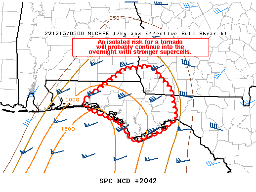
FOR ADDITIONAL INFORMATION SEE MESOSCALE DISCUSSION 2042
..SMITH..12/15/22
ATTN...WFO...BMX...MOB...TAE...
&&
STATUS REPORT FOR WT 589
SEVERE WEATHER THREAT CONTINUES FOR THE FOLLOWING AREAS
ALC045-061-067-069-150640-
AL
. ALABAMA COUNTIES INCLUDED ARE
DALE GENEVA HENRY
HOUSTON
$$
FLC005-013-037-039-045-059-063-073-077-091-129-131-133-150640-
FL
. FLORIDA COUNTIES INCLUDED ARE
BAY CALHOUN FRANKLIN
GADSDEN GULF HOLMES
JACKSON LEON LIBERTY
OKALOOSA WAKULLA WALTON
WASHINGTON
$$
GAC061-087-099-131-201-253-150640-
GA
. GEORGIA COUNTIES INCLUDED ARE
CLAY DECATUR EARLY
GRADY MILLER SEMINOLE
$$
GMZ635-636-655-750-752-755-150640-
CW
. ADJACENT COASTAL WATERS INCLUDED ARE
WESTERN CHOCTAWHATCHEE BAY
EASTERN CHOCTAWHATCHEE BAY
COASTAL WATERS FROM OKALOOSA-WALTON COUNTY LINE TO PENSACOLA FL
OUT 20 NM
COASTAL WATERS FROM OKALOOSA-WALTON COUNTY LINE TO MEXICO BEACH
OUT 20 NM
COASTAL WATERS FROM MEXICO BEACH TO APALACHICOLA OUT 20 NM
COASTAL WATERS FROM OCHLOCKONEE RIVER TO APALACHICOLA FL OUT TO
20 NM
$$
THE WATCH STATUS MESSAGE IS FOR GUIDANCE PURPOSES ONLY. PLEASE
REFER TO WATCH COUNTY NOTIFICATION STATEMENTS FOR OFFICIAL
INFORMATION ON COUNTIES...INDEPENDENT CITIES AND MARINE ZONES
CLEARED FROM SEVERE THUNDERSTORM AND TORNADO WATCHES.
$$
STATUS REPORT #2 ON WW 589
VALID 150355Z - 150440Z
SEVERE WEATHER THREAT CONTINUES RIGHT OF A LINE FROM 25 WSW PNS
TO 35 SSW GZH TO 15 SSE GZH TO 15 NNE GZH TO 15 WSW MGM TO 40 NW
AUO.
FOR ADDITIONAL INFORMATION SEE MESOSCALE DISCUSSION 2039
..LYONS..12/15/22
ATTN...WFO...BMX...MOB...TAE...
&&
STATUS REPORT FOR WT 589
SEVERE WEATHER THREAT CONTINUES FOR THE FOLLOWING AREAS
ALC005-011-013-031-039-041-045-051-061-067-069-081-087-101-109-
113-150440-
AL
. ALABAMA COUNTIES INCLUDED ARE
BARBOUR BULLOCK BUTLER
COFFEE COVINGTON CRENSHAW
DALE ELMORE GENEVA
HENRY HOUSTON LEE
MACON MONTGOMERY PIKE
RUSSELL
$$
FLC005-013-037-039-045-059-063-073-077-091-113-129-131-133-
150440-
FL
. FLORIDA COUNTIES INCLUDED ARE
BAY CALHOUN FRANKLIN
GADSDEN GULF HOLMES
JACKSON LEON LIBERTY
OKALOOSA SANTA ROSA WAKULLA
WALTON WASHINGTON
$$
GAC061-087-099-131-201-239-253-150440-
GA
. GEORGIA COUNTIES INCLUDED ARE
CLAY DECATUR EARLY
GRADY MILLER QUITMAN
SEMINOLE
$$
GMZ634-635-636-655-750-752-755-150440-
CW
. ADJACENT COASTAL WATERS INCLUDED ARE
PENSACOLA BAY AREA INCLUDING SANTA ROSA SOUND
WESTERN CHOCTAWHATCHEE BAY
EASTERN CHOCTAWHATCHEE BAY
COASTAL WATERS FROM OKALOOSA-WALTON COUNTY LINE TO PENSACOLA FL
OUT 20 NM
COASTAL WATERS FROM OKALOOSA-WALTON COUNTY LINE TO MEXICO BEACH
OUT 20 NM
COASTAL WATERS FROM MEXICO BEACH TO APALACHICOLA OUT 20 NM
COASTAL WATERS FROM OCHLOCKONEE RIVER TO APALACHICOLA FL OUT TO
20 NM
$$
THE WATCH STATUS MESSAGE IS FOR GUIDANCE PURPOSES ONLY. PLEASE
REFER TO WATCH COUNTY NOTIFICATION STATEMENTS FOR OFFICIAL
INFORMATION ON COUNTIES...INDEPENDENT CITIES AND MARINE ZONES
CLEARED FROM SEVERE THUNDERSTORM AND TORNADO WATCHES.
$$
STATUS REPORT #1 ON WW 589
VALID 150040Z - 150140Z
THE SEVERE WEATHER THREAT CONTINUES ACROSS THE ENTIRE WATCH AREA.
..THORNTON..12/15/22
ATTN...WFO...BMX...MOB...TAE...
&&
STATUS REPORT FOR WT 589
SEVERE WEATHER THREAT CONTINUES FOR THE FOLLOWING AREAS
ALC001-005-011-013-031-035-039-041-045-051-053-061-067-069-081-
085-087-101-109-113-150140-
AL
. ALABAMA COUNTIES INCLUDED ARE
AUTAUGA BARBOUR BULLOCK
BUTLER COFFEE CONECUH
COVINGTON CRENSHAW DALE
ELMORE ESCAMBIA GENEVA
HENRY HOUSTON LEE
LOWNDES MACON MONTGOMERY
PIKE RUSSELL
$$
FLC005-013-033-037-039-045-059-063-077-091-113-131-133-150140-
FL
. FLORIDA COUNTIES INCLUDED ARE
BAY CALHOUN ESCAMBIA
FRANKLIN GADSDEN GULF
HOLMES JACKSON LIBERTY
OKALOOSA SANTA ROSA WALTON
WASHINGTON
$$
GAC061-087-099-201-239-253-150140-
GA
. GEORGIA COUNTIES INCLUDED ARE
CLAY DECATUR EARLY
MILLER QUITMAN SEMINOLE
$$
GMZ633-634-635-636-655-750-752-755-150140-
CW
. ADJACENT COASTAL WATERS INCLUDED ARE
PERDIDO BAY AREA
PENSACOLA BAY AREA INCLUDING SANTA ROSA SOUND
WESTERN CHOCTAWHATCHEE BAY
EASTERN CHOCTAWHATCHEE BAY
COASTAL WATERS FROM OKALOOSA-WALTON COUNTY LINE TO PENSACOLA FL
OUT 20 NM
COASTAL WATERS FROM OKALOOSA-WALTON COUNTY LINE TO MEXICO BEACH
OUT 20 NM
COASTAL WATERS FROM MEXICO BEACH TO APALACHICOLA OUT 20 NM
COASTAL WATERS FROM OCHLOCKONEE RIVER TO APALACHICOLA FL OUT TO
20 NM
$$
THE WATCH STATUS MESSAGE IS FOR GUIDANCE PURPOSES ONLY. PLEASE
REFER TO WATCH COUNTY NOTIFICATION STATEMENTS FOR OFFICIAL
INFORMATION ON COUNTIES...INDEPENDENT CITIES AND MARINE ZONES
CLEARED FROM SEVERE THUNDERSTORM AND TORNADO WATCHES.
$$
Note:
Click for Complete Product Text.
Tornadoes
Probability of 2 or more tornadoes
|
High (80%)
|
Probability of 1 or more strong (EF2-EF5) tornadoes
|
Mod (50%)
|
Wind
Probability of 10 or more severe wind events
|
Mod (40%)
|
Probability of 1 or more wind events > 65 knots
|
Low (10%)
|
Hail
Probability of 10 or more severe hail events
|
Low (<5%)
|
Probability of 1 or more hailstones > 2 inches
|
Low (<5%)
|
Combined Severe Hail/Wind
Probability of 6 or more combined severe hail/wind events
|
Mod (50%)
|
For each watch, probabilities for particular events inside the watch
(listed above in each table) are determined by the issuing forecaster.
The "Low" category contains probability values ranging from less than 2%
to 20% (EF2-EF5 tornadoes), less than 5% to 20% (all other probabilities),
"Moderate" from 30% to 60%, and "High" from 70% to greater than 95%.
High values are bolded and lighter in color to provide awareness of
an increased threat for a particular event.


 @NWSSPC