 Note:
The expiration time in the watch graphic is amended if the watch is
replaced, cancelled or extended.
Note:
Note:
The expiration time in the watch graphic is amended if the watch is
replaced, cancelled or extended.
Note: Click for
Watch Status Reports.
SEL8
URGENT - IMMEDIATE BROADCAST REQUESTED
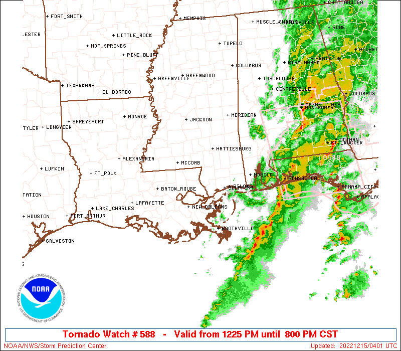
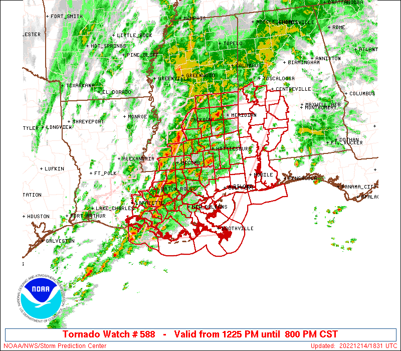
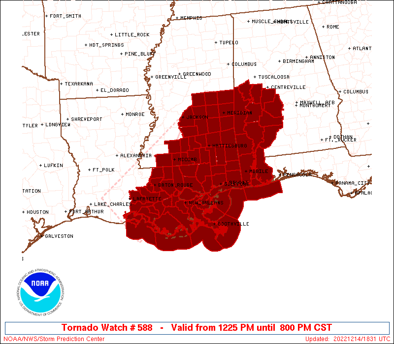
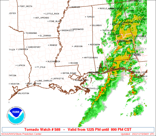
Tornado Watch Number 588
NWS Storm Prediction Center Norman OK
1225 PM CST Wed Dec 14 2022
The NWS Storm Prediction Center has issued a
* Tornado Watch for portions of
Southwest Alabama
Southeast Louisiana
Southern and Central Mississippi
Coastal Waters
* Effective this Wednesday afternoon and evening from 1225 PM
until 800 PM CST.
...THIS IS A PARTICULARLY DANGEROUS SITUATION...
* Primary threats include...
Numerous tornadoes expected with a few intense tornadoes likely
Scattered damaging wind gusts to 70 mph possible
Isolated large hail events to 1.5 inches in diameter possible
SUMMARY...Numerous supercell thunderstorms have formed and will
affect portions of the watch area through the afternoon and early
evening. Strong winds aloft and ample instability will pose a risk
of several tornadoes, including a few strong tornadoes.
The tornado watch area is approximately along and 80 statute miles
east and west of a line from 30 miles south southeast of Houma LA to
25 miles northeast of Meridian MS. For a complete depiction of the
watch see the associated watch outline update (WOUS64 KWNS WOU8).
PRECAUTIONARY/PREPAREDNESS ACTIONS...
REMEMBER...A Tornado Watch means conditions are favorable for
tornadoes and severe thunderstorms in and close to the watch
area. Persons in these areas should be on the lookout for
threatening weather conditions and listen for later statements
and possible warnings.
&&
OTHER WATCH INFORMATION...CONTINUE...WW 587...
AVIATION...Tornadoes and a few severe thunderstorms with hail
surface and aloft to 1.5 inches. Extreme turbulence and surface wind
gusts to 60 knots. A few cumulonimbi with maximum tops to 500. Mean
storm motion vector 23035.
...Hart

   SEL8

   URGENT - IMMEDIATE BROADCAST REQUESTED
   Tornado Watch Number 588
   NWS Storm Prediction Center Norman OK
   1225 PM CST Wed Dec 14 2022

   The NWS Storm Prediction Center has issued a

   * Tornado Watch for portions of
     Southwest Alabama
     Southeast Louisiana
     Southern and Central Mississippi
     Coastal Waters

   * Effective this Wednesday afternoon and evening from 1225 PM
     until 800 PM CST.

   ...THIS IS A PARTICULARLY DANGEROUS SITUATION...

   * Primary threats include...
     Numerous tornadoes expected with a few intense tornadoes likely
     Scattered damaging wind gusts to 70 mph possible
     Isolated large hail events to 1.5 inches in diameter possible

   SUMMARY...Numerous supercell thunderstorms have formed and will
   affect portions of the watch area through the afternoon and early
   evening.  Strong winds aloft and ample instability will pose a risk
   of several tornadoes, including a few strong tornadoes.

   The tornado watch area is approximately along and 80 statute miles
   east and west of a line from 30 miles south southeast of Houma LA to
   25 miles northeast of Meridian MS. For a complete depiction of the
   watch see the associated watch outline update (WOUS64 KWNS WOU8).

   PRECAUTIONARY/PREPAREDNESS ACTIONS...

   REMEMBER...A Tornado Watch means conditions are favorable for
   tornadoes and severe thunderstorms in and close to the watch
   area. Persons in these areas should be on the lookout for
   threatening weather conditions and listen for later statements
   and possible warnings.

   &&

   OTHER WATCH INFORMATION...CONTINUE...WW 587...

   AVIATION...Tornadoes and a few severe thunderstorms with hail
   surface and aloft to 1.5 inches. Extreme turbulence and surface wind
   gusts to 60 knots. A few cumulonimbi with maximum tops to 500. Mean
   storm motion vector 23035.

   ...Hart
 Note:
The Aviation Watch (SAW) product is an approximation to the watch area.
The actual watch is depicted by the shaded areas.
Note:
The Aviation Watch (SAW) product is an approximation to the watch area.
The actual watch is depicted by the shaded areas.
   SAW8
   WW 588 TORNADO AL LA MS CW 141825Z - 150200Z
   AXIS..80 STATUTE MILES EAST AND WEST OF LINE..
   30SSE HUM/HOUMA LA/ - 25NE MEI/MERIDIAN MS/
   ..AVIATION COORDS.. 70NM E/W /20W LEV - 22NE MEI/
   HAIL SURFACE AND ALOFT..1.5 INCHES. WIND GUSTS..60 KNOTS.
   MAX TOPS TO 500. MEAN STORM MOTION VECTOR 23035.

   LAT...LON 29169181 32588982 32588707 29168915

   THIS IS AN APPROXIMATION TO THE WATCH AREA.  FOR A
   COMPLETE DEPICTION OF THE WATCH SEE WOUS64 KWNS
   FOR WOU8.
Watch 588 Status Report Messages:
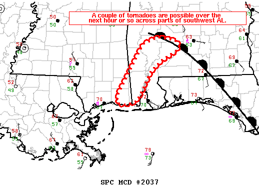
STATUS REPORT #4 ON WW 588

VALID 150030Z - 150140Z

SEVERE WEATHER THREAT CONTINUES RIGHT OF A LINE FROM 50 SE HUM TO
55 N MOB TO 35 WNW SEM TO 30 SE TCL.

FOR ADDITIONAL INFORMATION SEE MESOSCALE DISCUSSION 2037

..THORNTON..12/15/22

ATTN...WFO...MOB...BMX...LIX...LCH...JAN...

&&

STATUS REPORT FOR WT 588

SEVERE WEATHER THREAT CONTINUES FOR THE FOLLOWING AREAS

ALC003-025-047-097-099-105-129-131-150140-

AL
.    ALABAMA COUNTIES INCLUDED ARE

BALDWIN 	     CLARKE		 DALLAS
MOBILE		     MONROE		 PERRY
WASHINGTON	     WILCOX
$$


LAC075-150140-

LA
.    LOUISIANA PARISHES INCLUDED ARE

PLAQUEMINES
$$


MSC039-059-150140-

MS
.    MISSISSIPPI COUNTIES INCLUDED ARE

GEORGE		     JACKSON
$$


GMZ532-536-538-552-555-557-630-631-632-650-150140-

CW

.    ADJACENT COASTAL WATERS INCLUDED ARE

MISSISSIPPI SOUND

CHANDELEUR SOUND

BRETON SOUND

COASTAL WATERS FROM THE SOUTHWEST PASS OF THE MISSISSIPPI RIVER
TO PORT FOURCHON LOUISIANA OUT 20 NM

COASTAL WATERS FROM BOOTHVILLE LA TO SOUTHWEST PASS OF THE
MISSISSIPPI RIVER OUT 20 NM

COASTAL WATERS FROM PASCAGOULA MISSISSIPPI TO STAKE ISLAND OUT 20
NM

NORTH MOBILE BAY

SOUTH MOBILE BAY

MISSISSIPPI SOUND

COASTAL WATERS FROM PENSACOLA FL TO PASCAGOULA MS OUT 20 NM

$$
THE WATCH STATUS MESSAGE IS FOR GUIDANCE PURPOSES ONLY.  PLEASE
REFER TO WATCH COUNTY NOTIFICATION STATEMENTS FOR OFFICIAL
INFORMATION ON COUNTIES...INDEPENDENT CITIES AND MARINE ZONES
CLEARED FROM SEVERE THUNDERSTORM AND TORNADO WATCHES.
$$

STATUS REPORT #3 ON WW 588

VALID 142350Z - 150040Z

THE SEVERE WEATHER THREAT CONTINUES ACROSS THE ENTIRE WATCH AREA.

..THORNTON..12/14/22

ATTN...WFO...MOB...BMX...LIX...LCH...JAN...

&&

STATUS REPORT FOR WT 588

SEVERE WEATHER THREAT CONTINUES FOR THE FOLLOWING AREAS

ALC003-025-047-065-091-097-099-105-129-131-150040-

AL
.    ALABAMA COUNTIES INCLUDED ARE

BALDWIN 	     CLARKE		 DALLAS
HALE		     MARENGO		 MOBILE
MONROE		     PERRY		 WASHINGTON
WILCOX
$$


LAC075-150040-

LA
.    LOUISIANA PARISHES INCLUDED ARE

PLAQUEMINES
$$


MSC039-041-047-059-131-150040-

MS
.    MISSISSIPPI COUNTIES INCLUDED ARE

GEORGE		     GREENE		 HARRISON
JACKSON 	     STONE
$$


GMZ532-534-536-538-552-555-557-630-631-632-650-150040-

CW

.    ADJACENT COASTAL WATERS INCLUDED ARE

MISSISSIPPI SOUND

LAKE BORGNE

CHANDELEUR SOUND

BRETON SOUND

COASTAL WATERS FROM THE SOUTHWEST PASS OF THE MISSISSIPPI RIVER
TO PORT FOURCHON LOUISIANA OUT 20 NM

COASTAL WATERS FROM BOOTHVILLE LA TO SOUTHWEST PASS OF THE
MISSISSIPPI RIVER OUT 20 NM

COASTAL WATERS FROM PASCAGOULA MISSISSIPPI TO STAKE ISLAND OUT 20
NM

NORTH MOBILE BAY

SOUTH MOBILE BAY

MISSISSIPPI SOUND

COASTAL WATERS FROM PENSACOLA FL TO PASCAGOULA MS OUT 20 NM

$$
THE WATCH STATUS MESSAGE IS FOR GUIDANCE PURPOSES ONLY.  PLEASE
REFER TO WATCH COUNTY NOTIFICATION STATEMENTS FOR OFFICIAL
INFORMATION ON COUNTIES...INDEPENDENT CITIES AND MARINE ZONES
CLEARED FROM SEVERE THUNDERSTORM AND TORNADO WATCHES.
$$

STATUS REPORT #2 ON WW 588

VALID 142245Z - 142340Z

SEVERE WEATHER THREAT CONTINUES RIGHT OF A LINE FROM 25 S HUM TO
45 ENE MEI.

FOR ADDITIONAL INFORMATION SEE MESOSCALE DISCUSSION 2034

..SMITH..12/14/22

ATTN...WFO...MOB...BMX...LIX...LCH...JAN...

&&

STATUS REPORT FOR WT 588

SEVERE WEATHER THREAT CONTINUES FOR THE FOLLOWING AREAS

ALC003-023-025-047-063-065-091-097-099-105-119-129-131-142340-

AL
.    ALABAMA COUNTIES INCLUDED ARE

BALDWIN 	     CHOCTAW		 CLARKE
DALLAS		     GREENE		 HALE
MARENGO 	     MOBILE		 MONROE
PERRY		     SUMTER		 WASHINGTON
WILCOX
$$


LAC051-057-071-075-087-089-109-142340-

LA
.    LOUISIANA PARISHES INCLUDED ARE

JEFFERSON	     LAFOURCHE		 ORLEANS
PLAQUEMINES	     ST. BERNARD	 ST. CHARLES
TERREBONNE
$$


MSC039-041-045-047-059-111-131-153-142340-

MS
.    MISSISSIPPI COUNTIES INCLUDED ARE

GEORGE		     GREENE		 HANCOCK
HARRISON	     JACKSON		 PERRY
STONE		     WAYNE
$$


GMZ530-532-534-536-538-550-552-555-557-630-631-632-650-142340-

CW

.    ADJACENT COASTAL WATERS INCLUDED ARE

LAKE PONTCHARTRAIN AND LAKE MAUREPAS

MISSISSIPPI SOUND

LAKE BORGNE

CHANDELEUR SOUND

BRETON SOUND

COASTAL WATERS FROM PORT FOURCHON LA TO LOWER ATCHAFALAYA RIVER
LA OUT 20 NM

COASTAL WATERS FROM THE SOUTHWEST PASS OF THE MISSISSIPPI RIVER
TO PORT FOURCHON LOUISIANA OUT 20 NM

COASTAL WATERS FROM BOOTHVILLE LA TO SOUTHWEST PASS OF THE
MISSISSIPPI RIVER OUT 20 NM

COASTAL WATERS FROM PASCAGOULA MISSISSIPPI TO STAKE ISLAND OUT 20
NM

NORTH MOBILE BAY

SOUTH MOBILE BAY

MISSISSIPPI SOUND

COASTAL WATERS FROM PENSACOLA FL TO PASCAGOULA MS OUT 20 NM

$$
THE WATCH STATUS MESSAGE IS FOR GUIDANCE PURPOSES ONLY.  PLEASE
REFER TO WATCH COUNTY NOTIFICATION STATEMENTS FOR OFFICIAL
INFORMATION ON COUNTIES...INDEPENDENT CITIES AND MARINE ZONES
CLEARED FROM SEVERE THUNDERSTORM AND TORNADO WATCHES.
$$

STATUS REPORT #1 ON WW 588

VALID 142020Z - 142140Z

SEVERE WEATHER THREAT CONTINUES RIGHT OF A LINE FROM 50 S 7R4 TO
30 SE 7R4 TO 35 E 7R4 TO 45 NW HUM TO 25 S MCB TO 35 W PIB TO 50
W MEI TO 45 SE GWO.

..BENTLEY..12/14/22

ATTN...WFO...MOB...BMX...LIX...LCH...JAN...

&&

STATUS REPORT FOR WT 588

SEVERE WEATHER THREAT CONTINUES FOR THE FOLLOWING AREAS

ALC003-023-025-047-063-065-091-097-099-105-119-129-131-142140-

AL
.    ALABAMA COUNTIES INCLUDED ARE

BALDWIN 	     CHOCTAW		 CLARKE
DALLAS		     GREENE		 HALE
MARENGO 	     MOBILE		 MONROE
PERRY		     SUMTER		 WASHINGTON
WILCOX
$$


LAC005-007-051-057-063-071-075-087-089-093-095-101-103-105-109-
117-142140-

LA
.    LOUISIANA PARISHES INCLUDED ARE

ASCENSION	     ASSUMPTION 	 JEFFERSON
LAFOURCHE	     LIVINGSTON 	 ORLEANS
PLAQUEMINES	     ST. BERNARD	 ST. CHARLES
ST. JAMES	     ST. JOHN THE BAPTISTST. MARY
ST. TAMMANY	     TANGIPAHOA 	 TERREBONNE
WASHINGTON
$$


MSC023-031-035-039-041-045-047-059-061-065-067-069-073-075-079-
091-099-101-109-111-123-129-131-147-153-142140-

MS
.    MISSISSIPPI COUNTIES INCLUDED ARE

CLARKE		     COVINGTON		 FORREST
GEORGE		     GREENE		 HANCOCK
HARRISON	     JACKSON		 JASPER
JEFFERSON DAVIS      JONES		 KEMPER
LAMAR		     LAUDERDALE 	 LEAKE
MARION		     NESHOBA		 NEWTON
PEARL RIVER	     PERRY		 SCOTT
SMITH		     STONE		 WALTHALL
WAYNE
$$


GMZ455-530-532-534-536-538-550-552-555-557-630-631-632-650-
142140-

CW

.    ADJACENT COASTAL WATERS INCLUDED ARE

COASTAL WATERS FROM LOWER ATCHAFALAYA RIVER TO INTRACOASTAL CITY
LA OUT 20 NM

LAKE PONTCHARTRAIN AND LAKE MAUREPAS

MISSISSIPPI SOUND

LAKE BORGNE

CHANDELEUR SOUND

BRETON SOUND

COASTAL WATERS FROM PORT FOURCHON LA TO LOWER ATCHAFALAYA RIVER
LA OUT 20 NM

COASTAL WATERS FROM THE SOUTHWEST PASS OF THE MISSISSIPPI RIVER
TO PORT FOURCHON LOUISIANA OUT 20 NM

COASTAL WATERS FROM BOOTHVILLE LA TO SOUTHWEST PASS OF THE
MISSISSIPPI RIVER OUT 20 NM

COASTAL WATERS FROM PASCAGOULA MISSISSIPPI TO STAKE ISLAND OUT 20
NM

NORTH MOBILE BAY

SOUTH MOBILE BAY

MISSISSIPPI SOUND

COASTAL WATERS FROM PENSACOLA FL TO PASCAGOULA MS OUT 20 NM

$$
THE WATCH STATUS MESSAGE IS FOR GUIDANCE PURPOSES ONLY.  PLEASE
REFER TO WATCH COUNTY NOTIFICATION STATEMENTS FOR OFFICIAL
INFORMATION ON COUNTIES...INDEPENDENT CITIES AND MARINE ZONES
CLEARED FROM SEVERE THUNDERSTORM AND TORNADO WATCHES.
$$
Note:
Click for Complete Product Text.
Tornadoes
Probability of 2 or more tornadoes
|
High (>95%)
|
Probability of 1 or more strong (EF2-EF5) tornadoes
|
High (80%)
|
Wind
Probability of 10 or more severe wind events
|
Mod (40%)
|
Probability of 1 or more wind events > 65 knots
|
Low (20%)
|
Hail
Probability of 10 or more severe hail events
|
Low (20%)
|
Probability of 1 or more hailstones > 2 inches
|
Low (<5%)
|
Combined Severe Hail/Wind
Probability of 6 or more combined severe hail/wind events
|
High (70%)
|
For each watch, probabilities for particular events inside the watch
(listed above in each table) are determined by the issuing forecaster.
The "Low" category contains probability values ranging from less than 2%
to 20% (EF2-EF5 tornadoes), less than 5% to 20% (all other probabilities),
"Moderate" from 30% to 60%, and "High" from 70% to greater than 95%.
High values are bolded and lighter in color to provide awareness of
an increased threat for a particular event.


 @NWSSPC