|
| Mesoscale Discussion 2042 |
|
< Previous MD Next MD >
|
|
Mesoscale Discussion 2042
NWS Storm Prediction Center Norman OK
1128 PM CST Wed Dec 14 2022
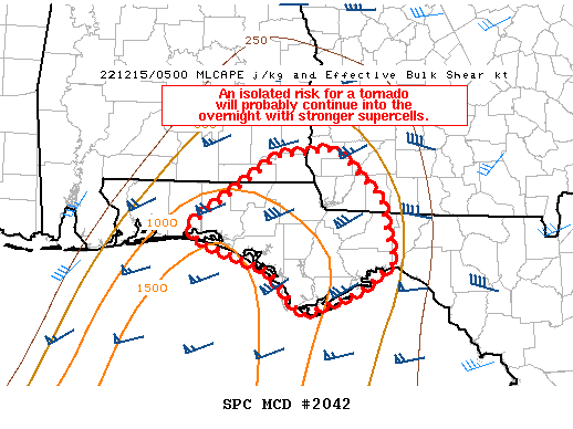
Areas affected...far southeast AL...far southwest GA...FL Panhandle
Concerning...Tornado Watch 589...
Valid 150528Z - 150730Z
The severe weather threat for Tornado Watch 589 continues.
SUMMARY...An isolated risk for a tornado will probably continue into
the overnight with stronger supercells. The primary limiting
factors for tornado potential may be weak low-level lapse rates and
the mid-level disturbance over the MS Valley and associated strong
forcing for ascent becoming increasingly displaced from the region.
Convective trends will be monitored for a possible small tornado
watch located to the east of Tornado Watch 589.
DISCUSSION...Radar mosaic shows a north-south zone of storms near
Apalachicola and a squall line on the front over the western FL
Panhandle extending southwest into the Gulf. The airmass over the
FL Panhandle is moist and marginally unstable 750-1000 J/kg MLCAPE
according to the latest RAP soundings when modified for current
surface conditions. Despite adequately large low-level hodographs,
water-vapor imagery suggests the strongest large-scale forcing for
ascent is becoming increasingly displaced from the northeast Gulf
Coast tonight. Furthermore, the relatively weak surface to 1.5 km
lapse rates are likely not favoring robust low-level updraft
acceleration, and consequently stronger low-level mesocyclones,
other than transient storm-scale rotation. However, with these
competing factors will probably maintain some risk for a tornado and
localized damaging gusts into the overnight hours.
..Smith.. 12/15/2022
...Please see www.spc.noaa.gov for graphic product...
ATTN...WFO...TAE...MOB...
LAT...LON 30538652 31278544 31348476 30858421 30168405 29868446
29628516 30088555 30378638 30538652
|
|
Top/All Mesoscale Discussions/Forecast Products/Home
|
|


 @NWSSPC