 Note:
The expiration time in the watch graphic is amended if the watch is
replaced, cancelled or extended.
Note:
Note:
The expiration time in the watch graphic is amended if the watch is
replaced, cancelled or extended.
Note: Click for
Watch Status Reports.
SEL7
URGENT - IMMEDIATE BROADCAST REQUESTED
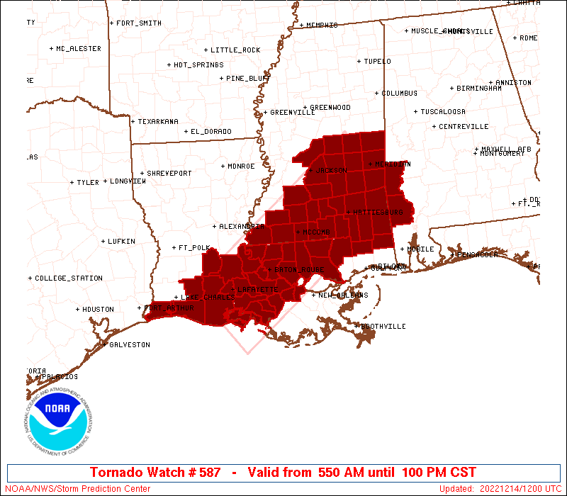
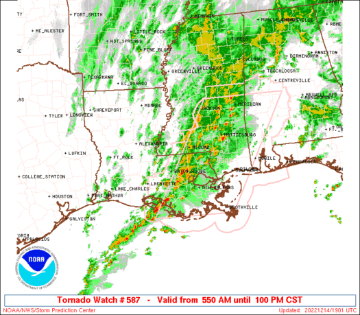
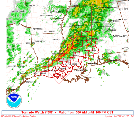
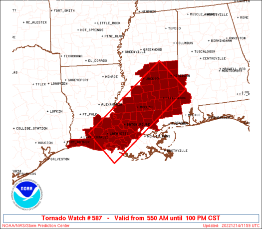
Tornado Watch Number 587
NWS Storm Prediction Center Norman OK
550 AM CST Wed Dec 14 2022
The NWS Storm Prediction Center has issued a
* Tornado Watch for portions of
Southwestern Alabama
Southern Louisiana
Central and southern Mississippi
Coastal Waters
* Effective this Wednesday morning and afternoon from 550 AM
until 100 PM CST.
* Primary threats include...
A few tornadoes and a couple intense tornadoes likely
Scattered damaging wind gusts to 70 mph possible
Isolated large hail events to 1.5 inches in diameter possible
SUMMARY...A primary band of severe thunderstorms should shift
eastward gradually across the watch area into early afternoon, with
embedded supercells and QLCS mesovortices offering tornado
potential. Any isolated to widely scattered thunderstorms ahead of
the line and along and south of a warm front also may persist long
enough, in a very favorable environment, to pose a tornado threat.
The tornado watch area is approximately along and 55 statute miles
either side of a line from 15 miles southwest of Intracoastal City
LA to 5 miles east northeast of Meridian MS. For a complete
depiction of the watch see the associated watch outline update
(WOUS64 KWNS WOU7).
PRECAUTIONARY/PREPAREDNESS ACTIONS...
REMEMBER...A Tornado Watch means conditions are favorable for
tornadoes and severe thunderstorms in and close to the watch
area. Persons in these areas should be on the lookout for
threatening weather conditions and listen for later statements
and possible warnings.
&&
OTHER WATCH INFORMATION...This tornado watch replaces tornado
watch number 586. Watch number 586 will not be in effect after
550 AM CST.
AVIATION...Tornadoes and a few severe thunderstorms with hail
surface and aloft to 1.5 inches. Extreme turbulence and surface wind
gusts to 60 knots. A few cumulonimbi with maximum tops to 500. Mean
storm motion vector 23035.
...Edwards
   SEL7

   URGENT - IMMEDIATE BROADCAST REQUESTED
   Tornado Watch Number 587
   NWS Storm Prediction Center Norman OK
   550 AM CST Wed Dec 14 2022

   The NWS Storm Prediction Center has issued a

   * Tornado Watch for portions of
     Southwestern Alabama
     Southern Louisiana
     Central and southern Mississippi
     Coastal Waters

   * Effective this Wednesday morning and afternoon from 550 AM
     until 100 PM CST.

   * Primary threats include...
     A few tornadoes and a couple intense tornadoes likely
     Scattered damaging wind gusts to 70 mph possible
     Isolated large hail events to 1.5 inches in diameter possible

   SUMMARY...A primary band of severe thunderstorms should shift
   eastward gradually across the watch area into early afternoon, with
   embedded supercells and QLCS mesovortices offering tornado
   potential.  Any isolated to widely scattered thunderstorms ahead of
   the line and along and south of a warm front also may persist long
   enough, in a very favorable environment, to pose a tornado threat.

   The tornado watch area is approximately along and 55 statute miles
   either side of a line from 15 miles southwest of Intracoastal City
   LA to 5 miles east northeast of Meridian MS. For a complete
   depiction of the watch see the associated watch outline update
   (WOUS64 KWNS WOU7).

   PRECAUTIONARY/PREPAREDNESS ACTIONS...

   REMEMBER...A Tornado Watch means conditions are favorable for
   tornadoes and severe thunderstorms in and close to the watch
   area. Persons in these areas should be on the lookout for
   threatening weather conditions and listen for later statements
   and possible warnings.

   &&

   OTHER WATCH INFORMATION...This tornado watch replaces tornado
   watch number 586. Watch number 586 will not be in effect after
   550 AM CST.

   AVIATION...Tornadoes and a few severe thunderstorms with hail
   surface and aloft to 1.5 inches. Extreme turbulence and surface wind
   gusts to 60 knots. A few cumulonimbi with maximum tops to 500. Mean
   storm motion vector 23035.

   ...Edwards
 Note:
The Aviation Watch (SAW) product is an approximation to the watch area.
The actual watch is depicted by the shaded areas.
Note:
The Aviation Watch (SAW) product is an approximation to the watch area.
The actual watch is depicted by the shaded areas.
   SAW7
   WW 587 TORNADO AL LA MS CW 141150Z - 141900Z
   AXIS..55 STATUTE MILES EITHER SIDE OF LINE..
   15SW 7R4/INTRACOASTAL CITY LA/ - 5ENE MEI/MERIDIAN MS/
   ..AVIATION COORDS.. 50NM EITHER SIDE /52SE LCH - 7ESE MEI/
   HAIL SURFACE AND ALOFT..1.5 INCHES. WIND GUSTS..60 KNOTS.
   MAX TOPS TO 500. MEAN STORM MOTION VECTOR 23035.

   REPLACES WW 586..LA MS

   LAT...LON 30269286 32998924 31728811 28999176

   THIS IS AN APPROXIMATION TO THE WATCH AREA.  FOR A
   COMPLETE DEPICTION OF THE WATCH SEE WOUS64 KWNS
   FOR WOU7.
Watch 587 Status Report Messages:
STATUS REPORT #2 ON WW 587
VALID 141630Z - 141740Z
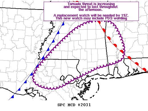
THE SEVERE WEATHER THREAT CONTINUES ACROSS THE ENTIRE WATCH AREA.
FOR ADDITIONAL INFORMATION SEE MESOSCALE DISCUSSION 2030
..BENTLEY..12/14/22
ATTN...WFO...MOB...LCH...LIX...JAN...
&&
STATUS REPORT FOR WT 587
SEVERE WEATHER THREAT CONTINUES FOR THE FOLLOWING AREAS
ALC023-129-141740-
AL
. ALABAMA COUNTIES INCLUDED ARE
CHOCTAW WASHINGTON
$$
LAC001-005-007-023-033-037-039-045-047-053-055-063-077-091-093-
095-097-099-101-103-105-113-117-121-125-141740-
LA
. LOUISIANA PARISHES INCLUDED ARE
ACADIA ASCENSION ASSUMPTION
CAMERON EAST BATON ROUGE EAST FELICIANA
EVANGELINE IBERIA IBERVILLE
JEFFERSON DAVIS LAFAYETTE LIVINGSTON
POINTE COUPEE ST. HELENA ST. JAMES
ST. JOHN THE BAPTIST ST. LANDRY ST. MARTIN
ST. MARY ST. TAMMANY TANGIPAHOA
VERMILION WASHINGTON WEST BATON ROUGE
WEST FELICIANA
$$
MSC005-023-029-031-035-037-039-041-061-065-067-069-073-075-077-
079-085-089-091-099-101-109-111-113-121-123-127-129-131-147-153-
157-141740-
MS
. MISSISSIPPI COUNTIES INCLUDED ARE
AMITE CLARKE COPIAH
COVINGTON FORREST FRANKLIN
GEORGE GREENE JASPER
JEFFERSON DAVIS JONES KEMPER
LAMAR LAUDERDALE LAWRENCE
LEAKE LINCOLN MADISON
MARION NESHOBA NEWTON
PEARL RIVER PERRY PIKE
RANKIN SCOTT SIMPSON
SMITH STONE WALTHALL
WAYNE WILKINSON
$$
GMZ432-435-141740-
CW
. ADJACENT COASTAL WATERS INCLUDED ARE
CALCASIEU LAKE
VERMILION BAY
$$
THE WATCH STATUS MESSAGE IS FOR GUIDANCE PURPOSES ONLY. PLEASE
REFER TO WATCH COUNTY NOTIFICATION STATEMENTS FOR OFFICIAL
INFORMATION ON COUNTIES...INDEPENDENT CITIES AND MARINE ZONES
CLEARED FROM SEVERE THUNDERSTORM AND TORNADO WATCHES.
$$
STATUS REPORT #1 ON WW 587
VALID 141340Z - 141440Z
THE SEVERE WEATHER THREAT CONTINUES ACROSS THE ENTIRE WATCH AREA.
..LEITMAN..12/14/22
ATTN...WFO...MOB...LCH...LIX...JAN...
&&
STATUS REPORT FOR WT 587
SEVERE WEATHER THREAT CONTINUES FOR THE FOLLOWING AREAS
ALC023-129-141440-
AL
. ALABAMA COUNTIES INCLUDED ARE
CHOCTAW WASHINGTON
$$
LAC001-005-007-023-033-037-039-045-047-053-055-063-077-091-093-
095-097-099-101-103-105-113-117-121-125-141440-
LA
. LOUISIANA PARISHES INCLUDED ARE
ACADIA ASCENSION ASSUMPTION
CAMERON EAST BATON ROUGE EAST FELICIANA
EVANGELINE IBERIA IBERVILLE
JEFFERSON DAVIS LAFAYETTE LIVINGSTON
POINTE COUPEE ST. HELENA ST. JAMES
ST. JOHN THE BAPTIST ST. LANDRY ST. MARTIN
ST. MARY ST. TAMMANY TANGIPAHOA
VERMILION WASHINGTON WEST BATON ROUGE
WEST FELICIANA
$$
MSC005-023-029-031-035-037-039-041-061-065-067-069-073-075-077-
079-085-089-091-099-101-109-111-113-121-123-127-129-131-147-153-
157-141440-
MS
. MISSISSIPPI COUNTIES INCLUDED ARE
AMITE CLARKE COPIAH
COVINGTON FORREST FRANKLIN
GEORGE GREENE JASPER
JEFFERSON DAVIS JONES KEMPER
LAMAR LAUDERDALE LAWRENCE
LEAKE LINCOLN MADISON
MARION NESHOBA NEWTON
PEARL RIVER PERRY PIKE
RANKIN SCOTT SIMPSON
SMITH STONE WALTHALL
WAYNE WILKINSON
$$
GMZ432-435-141440-
CW
. ADJACENT COASTAL WATERS INCLUDED ARE
CALCASIEU LAKE
VERMILION BAY
$$
THE WATCH STATUS MESSAGE IS FOR GUIDANCE PURPOSES ONLY. PLEASE
REFER TO WATCH COUNTY NOTIFICATION STATEMENTS FOR OFFICIAL
INFORMATION ON COUNTIES...INDEPENDENT CITIES AND MARINE ZONES
CLEARED FROM SEVERE THUNDERSTORM AND TORNADO WATCHES.
$$
Note:
Click for Complete Product Text.
Tornadoes
Probability of 2 or more tornadoes
|
High (70%)
|
Probability of 1 or more strong (EF2-EF5) tornadoes
|
Mod (60%)
|
Wind
Probability of 10 or more severe wind events
|
Mod (40%)
|
Probability of 1 or more wind events > 65 knots
|
Low (20%)
|
Hail
Probability of 10 or more severe hail events
|
Low (20%)
|
Probability of 1 or more hailstones > 2 inches
|
Low (10%)
|
Combined Severe Hail/Wind
Probability of 6 or more combined severe hail/wind events
|
Mod (60%)
|
For each watch, probabilities for particular events inside the watch
(listed above in each table) are determined by the issuing forecaster.
The "Low" category contains probability values ranging from less than 2%
to 20% (EF2-EF5 tornadoes), less than 5% to 20% (all other probabilities),
"Moderate" from 30% to 60%, and "High" from 70% to greater than 95%.
High values are bolded and lighter in color to provide awareness of
an increased threat for a particular event.


 @NWSSPC