Note:
The expiration time in the watch graphic is amended if the watch is
replaced, cancelled or extended.
Note:
Note:
The expiration time in the watch graphic is amended if the watch is
replaced, cancelled or extended.
Note: Click for
Watch Status Reports.
SEL6
URGENT - IMMEDIATE BROADCAST REQUESTED
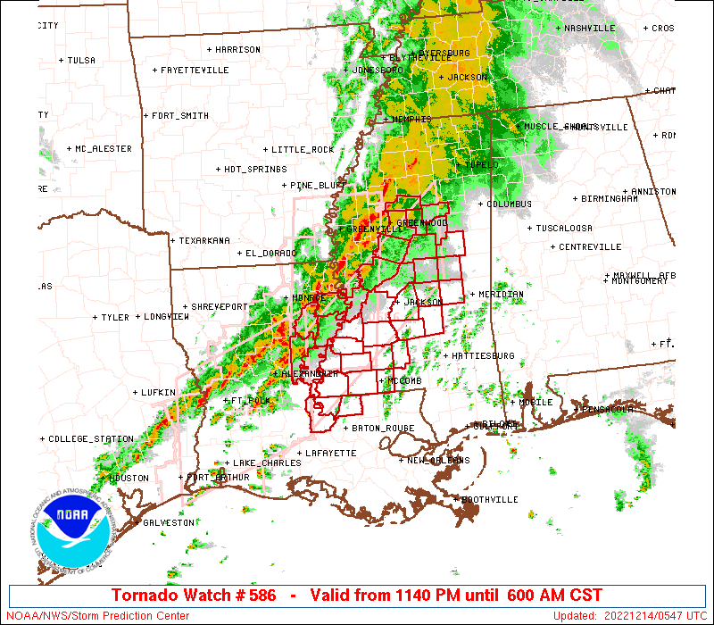
Tornado Watch Number 586
NWS Storm Prediction Center Norman OK
1140 PM CST Tue Dec 13 2022
The NWS Storm Prediction Center has issued a
* Tornado Watch for portions of
Central to northeast Louisiana
Southwest to central Mississippi
* Effective this Tuesday night and Wednesday morning from 1140 PM
until 600 AM CST.
* Primary threats include...
A few tornadoes likely with a couple intense tornadoes possible
Scattered damaging winds and isolated significant gusts to 75
mph possible
SUMMARY...A slow-moving line of thunderstorms will sag
east-southeast through daybreak. Discrete supercells ahead of this
line will pose the greatest threat for tornadoes.
The tornado watch area is approximately along and 50 statute miles
north and south of a line from 35 miles southwest of Natchez MS to
170 miles northeast of Natchez MS. For a complete depiction of the
watch see the associated watch outline update (WOUS64 KWNS WOU6).
PRECAUTIONARY/PREPAREDNESS ACTIONS...
REMEMBER...A Tornado Watch means conditions are favorable for
tornadoes and severe thunderstorms in and close to the watch
area. Persons in these areas should be on the lookout for
threatening weather conditions and listen for later statements
and possible warnings.
&&
OTHER WATCH INFORMATION...CONTINUE...WW 584...WW 585...
AVIATION...Tornadoes and a few severe thunderstorms with hail
surface and aloft to 1 inch. Extreme turbulence and surface wind
gusts to 65 knots. A few cumulonimbi with maximum tops to 450. Mean
storm motion vector 24035.
...Grams
 Note:
The Aviation Watch (SAW) product is an approximation to the watch area.
The actual watch is depicted by the shaded areas.
Note:
The Aviation Watch (SAW) product is an approximation to the watch area.
The actual watch is depicted by the shaded areas.
   SAW6
   WW 586 TORNADO LA MS 140540Z - 141200Z
   AXIS..50 STATUTE MILES NORTH AND SOUTH OF LINE..
   35SW HEZ/NATCHEZ MS/ - 170NE HEZ/NATCHEZ MS/
   ..AVIATION COORDS.. 45NM N/S /40E AEX - 36WSW IGB/
   HAIL SURFACE AND ALOFT..1 INCH. WIND GUSTS..65 KNOTS.
   MAX TOPS TO 450. MEAN STORM MOTION VECTOR 24035.

   LAT...LON 31989172 34078922 32628922 30549172

   THIS IS AN APPROXIMATION TO THE WATCH AREA.  FOR A
   COMPLETE DEPICTION OF THE WATCH SEE WOUS64 KWNS
   FOR WOU6.
Watch 586 Status Report Messages:
STATUS REPORT #6 ON WW 586

VALID 140940Z - 141040Z

SEVERE WEATHER THREAT CONTINUES RIGHT OF A LINE FROM 20 ESE ESF
TO 10 NE HEZ TO 55 NE HEZ TO 40 SSE GWO TO 30 WNW CBM.

..LEITMAN..12/14/22

ATTN...WFO...JAN...LIX...

&&

STATUS REPORT FOR WT 586

SEVERE WEATHER THREAT CONTINUES FOR THE FOLLOWING AREAS

LAC029-037-077-125-141040-

LA
.    LOUISIANA PARISHES INCLUDED ARE

CONCORDIA	     EAST FELICIANA	 POINTE COUPEE
WEST FELICIANA
$$


MSC001-005-007-019-021-029-037-049-051-063-077-079-085-089-099-
101-113-121-123-127-129-149-157-159-163-141040-

MS
.    MISSISSIPPI COUNTIES INCLUDED ARE

ADAMS		     AMITE		 ATTALA
CHOCTAW 	     CLAIBORNE		 COPIAH
FRANKLIN	     HINDS		 HOLMES
JEFFERSON	     LAWRENCE		 LEAKE
LINCOLN 	     MADISON		 NESHOBA
NEWTON		     PIKE		 RANKIN
SCOTT		     SIMPSON		 SMITH
WARREN		     WILKINSON		 WINSTON
YAZOO
$$


THE WATCH STATUS MESSAGE IS FOR GUIDANCE PURPOSES ONLY.  PLEASE
REFER TO WATCH COUNTY NOTIFICATION STATEMENTS FOR OFFICIAL
INFORMATION ON COUNTIES...INDEPENDENT CITIES AND MARINE ZONES
CLEARED FROM SEVERE THUNDERSTORM AND TORNADO WATCHES.
$$

STATUS REPORT #5 ON WW 586

VALID 140840Z - 140940Z

SEVERE WEATHER THREAT CONTINUES RIGHT OF A LINE FROM 15 ENE ESF
TO 35 NNE HEZ TO 30 ESE GWO TO 35 SW TUP.

FOR ADDITIONAL INFORMATION SEE MESOSCALE DISCUSSION 2027.

..LEITMAN..12/14/22

ATTN...WFO...JAN...LIX...

&&

STATUS REPORT FOR WT 586

SEVERE WEATHER THREAT CONTINUES FOR THE FOLLOWING AREAS

LAC025-029-037-077-107-125-140940-

LA
.    LOUISIANA PARISHES INCLUDED ARE

CATAHOULA	     CONCORDIA		 EAST FELICIANA
POINTE COUPEE	     TENSAS		 WEST FELICIANA
$$


MSC001-005-007-019-021-029-037-049-051-063-077-079-085-089-097-
099-101-113-121-123-127-129-149-155-157-159-163-140940-

MS
.    MISSISSIPPI COUNTIES INCLUDED ARE

ADAMS		     AMITE		 ATTALA
CHOCTAW 	     CLAIBORNE		 COPIAH
FRANKLIN	     HINDS		 HOLMES
JEFFERSON	     LAWRENCE		 LEAKE
LINCOLN 	     MADISON		 MONTGOMERY
NESHOBA 	     NEWTON		 PIKE
RANKIN		     SCOTT		 SIMPSON
SMITH		     WARREN		 WEBSTER
WILKINSON	     WINSTON		 YAZOO
$$


THE WATCH STATUS MESSAGE IS FOR GUIDANCE PURPOSES ONLY.  PLEASE
REFER TO WATCH COUNTY NOTIFICATION STATEMENTS FOR OFFICIAL
INFORMATION ON COUNTIES...INDEPENDENT CITIES AND MARINE ZONES
CLEARED FROM SEVERE THUNDERSTORM AND TORNADO WATCHES.
$$

STATUS REPORT #4 ON WW 586

VALID 140735Z - 140840Z

SEVERE WEATHER THREAT CONTINUES RIGHT OF A LINE FROM 15 NNE ESF
TO 40 N HEZ TO 50 SSW GWO TO 30 S UOX.

..LEITMAN..12/14/22

ATTN...WFO...JAN...LIX...

&&

STATUS REPORT FOR WT 586

SEVERE WEATHER THREAT CONTINUES FOR THE FOLLOWING AREAS

LAC025-029-037-065-077-107-125-140840-

LA
.    LOUISIANA PARISHES INCLUDED ARE

CATAHOULA	     CONCORDIA		 EAST FELICIANA
MADISON 	     POINTE COUPEE	 TENSAS
WEST FELICIANA
$$


MSC001-005-007-015-019-021-029-037-043-049-051-063-077-079-085-
089-097-099-101-113-121-123-127-129-149-155-157-159-163-
140840-

MS
.    MISSISSIPPI COUNTIES INCLUDED ARE

ADAMS		     AMITE		 ATTALA
CARROLL 	     CHOCTAW		 CLAIBORNE
COPIAH		     FRANKLIN		 GRENADA
HINDS		     HOLMES		 JEFFERSON
LAWRENCE	     LEAKE		 LINCOLN
MADISON 	     MONTGOMERY 	 NESHOBA
NEWTON		     PIKE		 RANKIN
SCOTT		     SIMPSON		 SMITH
WARREN		     WEBSTER		 WILKINSON
WINSTON 	     YAZOO
$$


THE WATCH STATUS MESSAGE IS FOR GUIDANCE PURPOSES ONLY.  PLEASE
REFER TO WATCH COUNTY NOTIFICATION STATEMENTS FOR OFFICIAL
INFORMATION ON COUNTIES...INDEPENDENT CITIES AND MARINE ZONES
CLEARED FROM SEVERE THUNDERSTORM AND TORNADO WATCHES.
$$

STATUS REPORT #3 ON WW 586

VALID 140640Z - 140740Z

THE SEVERE WEATHER THREAT CONTINUES ACROSS THE ENTIRE WATCH AREA.

..LEITMAN..12/14/22

ATTN...WFO...JAN...LIX...

&&

STATUS REPORT FOR WT 586

SEVERE WEATHER THREAT CONTINUES FOR THE FOLLOWING AREAS

LAC025-029-037-041-065-077-107-125-140740-

LA
.    LOUISIANA PARISHES INCLUDED ARE

CATAHOULA	     CONCORDIA		 EAST FELICIANA
FRANKLIN	     MADISON		 POINTE COUPEE
TENSAS		     WEST FELICIANA
$$


MSC001-005-007-015-019-021-029-037-043-049-051-063-077-079-085-
089-097-099-101-113-121-123-127-129-149-155-157-159-163-
140740-

MS
.    MISSISSIPPI COUNTIES INCLUDED ARE

ADAMS		     AMITE		 ATTALA
CARROLL 	     CHOCTAW		 CLAIBORNE
COPIAH		     FRANKLIN		 GRENADA
HINDS		     HOLMES		 JEFFERSON
LAWRENCE	     LEAKE		 LINCOLN
MADISON 	     MONTGOMERY 	 NESHOBA
NEWTON		     PIKE		 RANKIN
SCOTT		     SIMPSON		 SMITH
WARREN		     WEBSTER		 WILKINSON
WINSTON 	     YAZOO
$$


THE WATCH STATUS MESSAGE IS FOR GUIDANCE PURPOSES ONLY.  PLEASE
REFER TO WATCH COUNTY NOTIFICATION STATEMENTS FOR OFFICIAL
INFORMATION ON COUNTIES...INDEPENDENT CITIES AND MARINE ZONES
CLEARED FROM SEVERE THUNDERSTORM AND TORNADO WATCHES.
$$

STATUS REPORT #2 ON WW 586

VALID 140640Z - 140740Z

THE SEVERE WEATHER THREAT CONTINUES ACROSS THE ENTIRE WATCH AREA.

..LEITMAN..12/14/22

ATTN...WFO...JAN...LIX...

&&

STATUS REPORT FOR WT 586

SEVERE WEATHER THREAT CONTINUES FOR THE FOLLOWING AREAS

LAC025-029-037-041-065-077-107-125-140740-

LA
.    LOUISIANA PARISHES INCLUDED ARE

CATAHOULA	     CONCORDIA		 EAST FELICIANA
FRANKLIN	     MADISON		 POINTE COUPEE
TENSAS		     WEST FELICIANA
$$


MSC001-005-007-015-019-021-029-037-043-049-051-063-077-079-085-
089-097-099-101-113-121-123-127-129-149-155-157-159-163-
140740-

MS
.    MISSISSIPPI COUNTIES INCLUDED ARE

ADAMS		     AMITE		 ATTALA
CARROLL 	     CHOCTAW		 CLAIBORNE
COPIAH		     FRANKLIN		 GRENADA
HINDS		     HOLMES		 JEFFERSON
LAWRENCE	     LEAKE		 LINCOLN
MADISON 	     MONTGOMERY 	 NESHOBA
NEWTON		     PIKE		 RANKIN
SCOTT		     SIMPSON		 SMITH
WARREN		     WEBSTER		 WILKINSON
WINSTON 	     YAZOO
$$


THE WATCH STATUS MESSAGE IS FOR GUIDANCE PURPOSES ONLY.  PLEASE
REFER TO WATCH COUNTY NOTIFICATION STATEMENTS FOR OFFICIAL
INFORMATION ON COUNTIES...INDEPENDENT CITIES AND MARINE ZONES
CLEARED FROM SEVERE THUNDERSTORM AND TORNADO WATCHES.
$$

STATUS REPORT #1 ON WW 586

VALID 140545Z - 140640Z

THE SEVERE WEATHER THREAT CONTINUES ACROSS THE ENTIRE WATCH AREA.

..BROYLES..12/14/22

ATTN...WFO...JAN...LIX...

&&

STATUS REPORT FOR WT 586

SEVERE WEATHER THREAT CONTINUES FOR THE FOLLOWING AREAS

LAC025-029-037-041-065-077-107-125-140640-

LA
.    LOUISIANA PARISHES INCLUDED ARE

CATAHOULA	     CONCORDIA		 EAST FELICIANA
FRANKLIN	     MADISON		 POINTE COUPEE
TENSAS		     WEST FELICIANA
$$


MSC001-005-007-015-019-021-029-037-043-049-051-063-077-079-085-
089-097-099-101-113-121-123-127-129-149-155-157-159-163-
140640-

MS
.    MISSISSIPPI COUNTIES INCLUDED ARE

ADAMS		     AMITE		 ATTALA
CARROLL 	     CHOCTAW		 CLAIBORNE
COPIAH		     FRANKLIN		 GRENADA
HINDS		     HOLMES		 JEFFERSON
LAWRENCE	     LEAKE		 LINCOLN
MADISON 	     MONTGOMERY 	 NESHOBA
NEWTON		     PIKE		 RANKIN
SCOTT		     SIMPSON		 SMITH
WARREN		     WEBSTER		 WILKINSON
WINSTON 	     YAZOO
$$


THE WATCH STATUS MESSAGE IS FOR GUIDANCE PURPOSES ONLY.  PLEASE
REFER TO WATCH COUNTY NOTIFICATION STATEMENTS FOR OFFICIAL
INFORMATION ON COUNTIES...INDEPENDENT CITIES AND MARINE ZONES
CLEARED FROM SEVERE THUNDERSTORM AND TORNADO WATCHES.
$$
Note:
Click for Complete Product Text.
Tornadoes
Probability of 2 or more tornadoes
|
Mod (60%)
|
Probability of 1 or more strong (EF2-EF5) tornadoes
|
Mod (40%)
|
Wind
Probability of 10 or more severe wind events
|
Mod (40%)
|
Probability of 1 or more wind events > 65 knots
|
Mod (30%)
|
Hail
Probability of 10 or more severe hail events
|
Low (10%)
|
Probability of 1 or more hailstones > 2 inches
|
Low (10%)
|
Combined Severe Hail/Wind
Probability of 6 or more combined severe hail/wind events
|
Mod (60%)
|
For each watch, probabilities for particular events inside the watch
(listed above in each table) are determined by the issuing forecaster.
The "Low" category contains probability values ranging from less than 2%
to 20% (EF2-EF5 tornadoes), less than 5% to 20% (all other probabilities),
"Moderate" from 30% to 60%, and "High" from 70% to greater than 95%.
High values are bolded and lighter in color to provide awareness of
an increased threat for a particular event.


 @NWSSPC