Note:
The expiration time in the watch graphic is amended if the watch is
replaced, cancelled or extended.
Note:
Note:
The expiration time in the watch graphic is amended if the watch is
replaced, cancelled or extended.
Note: Click for
Watch Status Reports.
SEL2
URGENT - IMMEDIATE BROADCAST REQUESTED
Tornado Watch Number 552
NWS Storm Prediction Center Norman OK
300 PM CST Fri Dec 10 2021
The NWS Storm Prediction Center has issued a
* Tornado Watch for portions of
Central and northeastern Arkansas
Southern Illinois
Southwestern Indiana
Western Kentucky
Southeastern Missouri
Northwestern Mississippi
Western Tennessee
* Effective this Friday afternoon and evening from 300 PM until
1100 PM CST.
* Primary threats include...
Several tornadoes and a couple intense tornadoes likely
Scattered damaging winds likely with isolated significant gusts
to 75 mph possible
Scattered large hail and isolated very large hail events to 2
inches in diameter possible
SUMMARY...Scattered supercell development is expected this afternoon
through early tonight from central Arkansas northeastward toward the
confluence of the Mississippi and Ohio Rivers. Other storm
development is expected early tonight along a cold front moving into
Missouri and Arkansas. The storm environment will favor the
potential for a few strong tornadoes this evening through early
tonight, as well as damaging winds and large hail.
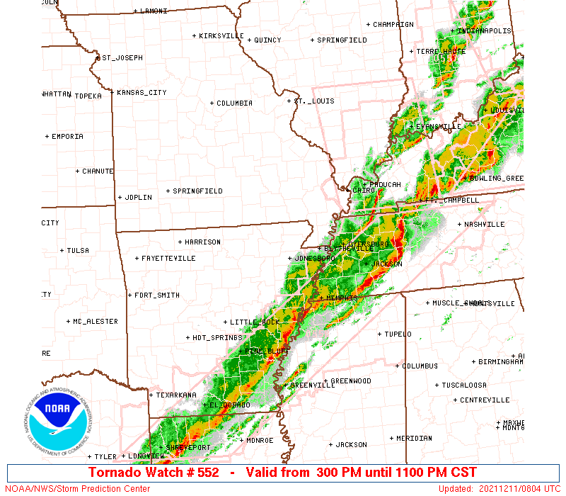
The tornado watch area is approximately along and 100 statute miles
east and west of a line from 10 miles west southwest of Pine Bluff
AR to 35 miles northeast of Carbondale IL. For a complete depiction
of the watch see the associated watch outline update (WOUS64 KWNS
WOU2).
PRECAUTIONARY/PREPAREDNESS ACTIONS...
REMEMBER...A Tornado Watch means conditions are favorable for
tornadoes and severe thunderstorms in and close to the watch
area. Persons in these areas should be on the lookout for
threatening weather conditions and listen for later statements
and possible warnings.
&&
AVIATION...Tornadoes and a few severe thunderstorms with hail
surface and aloft to 2 inches. Extreme turbulence and surface wind
gusts to 65 knots. A few cumulonimbi with maximum tops to 500. Mean
storm motion vector 24050.
...Thompson

   SEL2

   URGENT - IMMEDIATE BROADCAST REQUESTED
   Tornado Watch Number 552
   NWS Storm Prediction Center Norman OK
   300 PM CST Fri Dec 10 2021

   The NWS Storm Prediction Center has issued a

   * Tornado Watch for portions of
     Central and northeastern Arkansas
     Southern Illinois
     Southwestern Indiana
     Western Kentucky
     Southeastern Missouri
     Northwestern Mississippi
     Western Tennessee

   * Effective this Friday afternoon and evening from 300 PM until
     1100 PM CST.

   * Primary threats include...
     Several tornadoes and a couple intense tornadoes likely
     Scattered damaging winds likely with isolated significant gusts
       to 75 mph possible
     Scattered large hail and isolated very large hail events to 2
       inches in diameter possible

   SUMMARY...Scattered supercell development is expected this afternoon
   through early tonight from central Arkansas northeastward toward the
   confluence of the Mississippi and Ohio Rivers.  Other storm
   development is expected early tonight along a cold front moving into
   Missouri and Arkansas.  The storm environment will favor the
   potential for a few strong tornadoes this evening through early
   tonight, as well as damaging winds and large hail.

   The tornado watch area is approximately along and 100 statute miles
   east and west of a line from 10 miles west southwest of Pine Bluff
   AR to 35 miles northeast of Carbondale IL. For a complete depiction
   of the watch see the associated watch outline update (WOUS64 KWNS
   WOU2).

   PRECAUTIONARY/PREPAREDNESS ACTIONS...

   REMEMBER...A Tornado Watch means conditions are favorable for
   tornadoes and severe thunderstorms in and close to the watch
   area. Persons in these areas should be on the lookout for
   threatening weather conditions and listen for later statements
   and possible warnings.

   &&

   AVIATION...Tornadoes and a few severe thunderstorms with hail
   surface and aloft to 2 inches. Extreme turbulence and surface wind
   gusts to 65 knots. A few cumulonimbi with maximum tops to 500. Mean
   storm motion vector 24050.

   ...Thompson
 Note:
The Aviation Watch (SAW) product is an approximation to the watch area.
The actual watch is depicted by the shaded areas.
Note:
The Aviation Watch (SAW) product is an approximation to the watch area.
The actual watch is depicted by the shaded areas.
   SAW2
   WW 552 TORNADO AR IL IN KY MO MS TN 102100Z - 110500Z
   AXIS..100 STATUTE MILES EAST AND WEST OF LINE..
   10WSW PBF/PINE BLUFF AR/ - 35NE MDH/CARBONDALE IL/
   ..AVIATION COORDS.. 85NM E/W /34S LIT - 50WNW PXV/
   HAIL SURFACE AND ALOFT..2 INCHES. WIND GUSTS..65 KNOTS.
   MAX TOPS TO 500. MEAN STORM MOTION VECTOR 24050.

   LAT...LON 34099384 38129063 38128695 34099034

   THIS IS AN APPROXIMATION TO THE WATCH AREA.  FOR A
   COMPLETE DEPICTION OF THE WATCH SEE WOUS64 KWNS
   FOR WOU2.
Watch 552 Status Report Messages:
STATUS REPORT #4 ON WW 552

VALID 110220Z - 110340Z

THE SEVERE WEATHER THREAT CONTINUES ACROSS THE ENTIRE WATCH AREA.

FOR ADDITIONAL INFORMATION SEE MESOSCALE DISCUSSION 1992

..BENTLEY..12/11/21

ATTN...WFO...LZK...MEG...PAH...LSX...SGF...

&&

STATUS REPORT FOR WT 552

SEVERE WEATHER THREAT CONTINUES FOR THE FOLLOWING AREAS

ARC001-019-021-023-025-029-031-035-037-039-045-049-051-053-055-
059-063-065-067-069-075-077-079-085-093-095-097-105-107-109-111-
115-117-119-121-123-125-135-137-141-145-147-149-110340-

AR
.    ARKANSAS COUNTIES INCLUDED ARE

ARKANSAS	     CLARK		 CLAY
CLEBURNE	     CLEVELAND		 CONWAY
CRAIGHEAD	     CRITTENDEN 	 CROSS
DALLAS		     FAULKNER		 FULTON
GARLAND 	     GRANT		 GREENE
HOT SPRING	     INDEPENDENCE	 IZARD
JACKSON 	     JEFFERSON		 LAWRENCE
LEE		     LINCOLN		 LONOKE
MISSISSIPPI	     MONROE		 MONTGOMERY
PERRY		     PHILLIPS		 PIKE
POINSETT	     POPE		 PRAIRIE
PULASKI 	     RANDOLPH		 ST. FRANCIS
SALINE		     SHARP		 STONE
VAN BUREN	     WHITE		 WOODRUFF
YELL
$$


ILC003-047-055-059-065-069-077-081-087-127-133-145-151-153-157-
163-165-181-185-189-191-193-199-110340-

IL
.    ILLINOIS COUNTIES INCLUDED ARE

ALEXANDER	     EDWARDS		 FRANKLIN
GALLATIN	     HAMILTON		 HARDIN
JACKSON 	     JEFFERSON		 JOHNSON
MASSAC		     MONROE		 PERRY
POPE		     PULASKI		 RANDOLPH
ST. CLAIR	     SALINE		 UNION
WABASH		     WASHINGTON 	 WAYNE
WHITE		     WILLIAMSON
$$


INC051-125-129-147-163-173-110340-

IN
.    INDIANA COUNTIES INCLUDED ARE

GIBSON		     PIKE		 POSEY
SPENCER 	     VANDERBURGH	 WARRICK
$$


KYC007-033-035-039-055-059-075-083-101-105-107-139-143-145-149-
157-221-225-233-110340-

KY
.    KENTUCKY COUNTIES INCLUDED ARE

BALLARD 	     CALDWELL		 CALLOWAY
CARLISLE	     CRITTENDEN 	 DAVIESS
FULTON		     GRAVES		 HENDERSON
HICKMAN 	     HOPKINS		 LIVINGSTON
LYON		     MCCRACKEN		 MCLEAN
MARSHALL	     TRIGG		 UNION
WEBSTER
$$


MSC027-033-093-107-119-137-143-110340-

MS
.    MISSISSIPPI COUNTIES INCLUDED ARE

COAHOMA 	     DESOTO		 MARSHALL
PANOLA		     QUITMAN		 TATE
TUNICA
$$


MOC017-023-031-035-055-065-069-091-093-099-123-133-143-149-155-
157-179-181-186-187-201-203-207-215-221-223-110340-

MO
.    MISSOURI COUNTIES INCLUDED ARE

BOLLINGER	     BUTLER		 CAPE GIRARDEAU
CARTER		     CRAWFORD		 DENT
DUNKLIN 	     HOWELL		 IRON
JEFFERSON	     MADISON		 MISSISSIPPI
NEW MADRID	     OREGON		 PEMISCOT
PERRY		     REYNOLDS		 RIPLEY
STE. GENEVIEVE	     ST. FRANCOIS	 SCOTT
SHANNON 	     STODDARD		 TEXAS
WASHINGTON	     WAYNE
$$


TNC017-033-045-047-053-069-075-079-095-097-113-131-157-167-183-
110340-

TN
.    TENNESSEE COUNTIES INCLUDED ARE

CARROLL 	     CROCKETT		 DYER
FAYETTE 	     GIBSON		 HARDEMAN
HAYWOOD 	     HENRY		 LAKE
LAUDERDALE	     MADISON		 OBION
SHELBY		     TIPTON		 WEAKLEY
$$


THE WATCH STATUS MESSAGE IS FOR GUIDANCE PURPOSES ONLY.  PLEASE
REFER TO WATCH COUNTY NOTIFICATION STATEMENTS FOR OFFICIAL
INFORMATION ON COUNTIES...INDEPENDENT CITIES AND MARINE ZONES
CLEARED FROM SEVERE THUNDERSTORM AND TORNADO WATCHES.
$$

STATUS REPORT #3 ON WW 552

VALID 110055Z - 110140Z

THE SEVERE WEATHER THREAT CONTINUES ACROSS THE ENTIRE WATCH AREA.

..BENTLEY..12/11/21

ATTN...WFO...LZK...MEG...PAH...LSX...SGF...

&&

STATUS REPORT FOR WT 552

SEVERE WEATHER THREAT CONTINUES FOR THE FOLLOWING AREAS

ARC001-019-021-023-025-029-031-035-037-039-045-049-051-053-055-
059-063-065-067-069-075-077-079-085-093-095-097-105-107-109-111-
115-117-119-121-123-125-135-137-141-145-147-149-110140-

AR
.    ARKANSAS COUNTIES INCLUDED ARE

ARKANSAS	     CLARK		 CLAY
CLEBURNE	     CLEVELAND		 CONWAY
CRAIGHEAD	     CRITTENDEN 	 CROSS
DALLAS		     FAULKNER		 FULTON
GARLAND 	     GRANT		 GREENE
HOT SPRING	     INDEPENDENCE	 IZARD
JACKSON 	     JEFFERSON		 LAWRENCE
LEE		     LINCOLN		 LONOKE
MISSISSIPPI	     MONROE		 MONTGOMERY
PERRY		     PHILLIPS		 PIKE
POINSETT	     POPE		 PRAIRIE
PULASKI 	     RANDOLPH		 ST. FRANCIS
SALINE		     SHARP		 STONE
VAN BUREN	     WHITE		 WOODRUFF
YELL
$$


ILC003-047-055-059-065-069-077-081-087-127-133-145-151-153-157-
163-165-181-185-189-191-193-199-110140-

IL
.    ILLINOIS COUNTIES INCLUDED ARE

ALEXANDER	     EDWARDS		 FRANKLIN
GALLATIN	     HAMILTON		 HARDIN
JACKSON 	     JEFFERSON		 JOHNSON
MASSAC		     MONROE		 PERRY
POPE		     PULASKI		 RANDOLPH
ST. CLAIR	     SALINE		 UNION
WABASH		     WASHINGTON 	 WAYNE
WHITE		     WILLIAMSON
$$


INC051-125-129-147-163-173-110140-

IN
.    INDIANA COUNTIES INCLUDED ARE

GIBSON		     PIKE		 POSEY
SPENCER 	     VANDERBURGH	 WARRICK
$$


KYC007-033-035-039-055-059-075-083-101-105-107-139-143-145-149-
157-221-225-233-110140-

KY
.    KENTUCKY COUNTIES INCLUDED ARE

BALLARD 	     CALDWELL		 CALLOWAY
CARLISLE	     CRITTENDEN 	 DAVIESS
FULTON		     GRAVES		 HENDERSON
HICKMAN 	     HOPKINS		 LIVINGSTON
LYON		     MCCRACKEN		 MCLEAN
MARSHALL	     TRIGG		 UNION
WEBSTER
$$


MSC027-033-093-107-119-137-143-110140-

MS
.    MISSISSIPPI COUNTIES INCLUDED ARE

COAHOMA 	     DESOTO		 MARSHALL
PANOLA		     QUITMAN		 TATE
TUNICA
$$


MOC017-023-031-035-055-065-069-091-093-099-123-133-143-149-155-
157-179-181-186-187-201-203-207-215-221-223-110140-

MO
.    MISSOURI COUNTIES INCLUDED ARE

BOLLINGER	     BUTLER		 CAPE GIRARDEAU
CARTER		     CRAWFORD		 DENT
DUNKLIN 	     HOWELL		 IRON
JEFFERSON	     MADISON		 MISSISSIPPI
NEW MADRID	     OREGON		 PEMISCOT
PERRY		     REYNOLDS		 RIPLEY
STE. GENEVIEVE	     ST. FRANCOIS	 SCOTT
SHANNON 	     STODDARD		 TEXAS
WASHINGTON	     WAYNE
$$


TNC017-033-045-047-053-069-075-079-095-097-113-131-157-167-183-
110140-

TN
.    TENNESSEE COUNTIES INCLUDED ARE

CARROLL 	     CROCKETT		 DYER
FAYETTE 	     GIBSON		 HARDEMAN
HAYWOOD 	     HENRY		 LAKE
LAUDERDALE	     MADISON		 OBION
SHELBY		     TIPTON		 WEAKLEY
$$


THE WATCH STATUS MESSAGE IS FOR GUIDANCE PURPOSES ONLY.  PLEASE
REFER TO WATCH COUNTY NOTIFICATION STATEMENTS FOR OFFICIAL
INFORMATION ON COUNTIES...INDEPENDENT CITIES AND MARINE ZONES
CLEARED FROM SEVERE THUNDERSTORM AND TORNADO WATCHES.
$$

STATUS REPORT #2 ON WW 552

VALID 102330Z - 110040Z

THE SEVERE WEATHER THREAT CONTINUES ACROSS THE ENTIRE WATCH AREA.

..BENTLEY..12/10/21

ATTN...WFO...LZK...MEG...PAH...LSX...SGF...

&&

STATUS REPORT FOR WT 552

SEVERE WEATHER THREAT CONTINUES FOR THE FOLLOWING AREAS

ARC001-019-021-023-025-029-031-035-037-039-045-049-051-053-055-
059-063-065-067-069-075-077-079-085-093-095-097-105-107-109-111-
115-117-119-121-123-125-135-137-141-145-147-149-110040-

AR
.    ARKANSAS COUNTIES INCLUDED ARE

ARKANSAS	     CLARK		 CLAY
CLEBURNE	     CLEVELAND		 CONWAY
CRAIGHEAD	     CRITTENDEN 	 CROSS
DALLAS		     FAULKNER		 FULTON
GARLAND 	     GRANT		 GREENE
HOT SPRING	     INDEPENDENCE	 IZARD
JACKSON 	     JEFFERSON		 LAWRENCE
LEE		     LINCOLN		 LONOKE
MISSISSIPPI	     MONROE		 MONTGOMERY
PERRY		     PHILLIPS		 PIKE
POINSETT	     POPE		 PRAIRIE
PULASKI 	     RANDOLPH		 ST. FRANCIS
SALINE		     SHARP		 STONE
VAN BUREN	     WHITE		 WOODRUFF
YELL
$$


ILC003-047-055-059-065-069-077-081-087-127-133-145-151-153-157-
163-165-181-185-189-191-193-199-110040-

IL
.    ILLINOIS COUNTIES INCLUDED ARE

ALEXANDER	     EDWARDS		 FRANKLIN
GALLATIN	     HAMILTON		 HARDIN
JACKSON 	     JEFFERSON		 JOHNSON
MASSAC		     MONROE		 PERRY
POPE		     PULASKI		 RANDOLPH
ST. CLAIR	     SALINE		 UNION
WABASH		     WASHINGTON 	 WAYNE
WHITE		     WILLIAMSON
$$


INC051-125-129-147-163-173-110040-

IN
.    INDIANA COUNTIES INCLUDED ARE

GIBSON		     PIKE		 POSEY
SPENCER 	     VANDERBURGH	 WARRICK
$$


KYC007-033-035-039-055-059-075-083-101-105-107-139-143-145-149-
157-221-225-233-110040-

KY
.    KENTUCKY COUNTIES INCLUDED ARE

BALLARD 	     CALDWELL		 CALLOWAY
CARLISLE	     CRITTENDEN 	 DAVIESS
FULTON		     GRAVES		 HENDERSON
HICKMAN 	     HOPKINS		 LIVINGSTON
LYON		     MCCRACKEN		 MCLEAN
MARSHALL	     TRIGG		 UNION
WEBSTER
$$


MSC027-033-093-107-119-137-143-110040-

MS
.    MISSISSIPPI COUNTIES INCLUDED ARE

COAHOMA 	     DESOTO		 MARSHALL
PANOLA		     QUITMAN		 TATE
TUNICA
$$


MOC017-023-031-035-055-065-069-091-093-099-123-133-143-149-155-
157-179-181-186-187-201-203-207-215-221-223-110040-

MO
.    MISSOURI COUNTIES INCLUDED ARE

BOLLINGER	     BUTLER		 CAPE GIRARDEAU
CARTER		     CRAWFORD		 DENT
DUNKLIN 	     HOWELL		 IRON
JEFFERSON	     MADISON		 MISSISSIPPI
NEW MADRID	     OREGON		 PEMISCOT
PERRY		     REYNOLDS		 RIPLEY
STE. GENEVIEVE	     ST. FRANCOIS	 SCOTT
SHANNON 	     STODDARD		 TEXAS
WASHINGTON	     WAYNE
$$


TNC017-033-045-047-053-069-075-079-095-097-113-131-157-167-183-
110040-

TN
.    TENNESSEE COUNTIES INCLUDED ARE

CARROLL 	     CROCKETT		 DYER
FAYETTE 	     GIBSON		 HARDEMAN
HAYWOOD 	     HENRY		 LAKE
LAUDERDALE	     MADISON		 OBION
SHELBY		     TIPTON		 WEAKLEY
$$


THE WATCH STATUS MESSAGE IS FOR GUIDANCE PURPOSES ONLY.  PLEASE
REFER TO WATCH COUNTY NOTIFICATION STATEMENTS FOR OFFICIAL
INFORMATION ON COUNTIES...INDEPENDENT CITIES AND MARINE ZONES
CLEARED FROM SEVERE THUNDERSTORM AND TORNADO WATCHES.
$$

STATUS REPORT #1 ON WW 552

VALID 102255Z - 102340Z

THE SEVERE WEATHER THREAT CONTINUES ACROSS THE ENTIRE WATCH AREA.

FOR ADDITIONAL INFORMATION SEE MESOSCALE DISCUSSION 1982

..BENTLEY..12/10/21

ATTN...WFO...LZK...MEG...PAH...LSX...SGF...

&&

STATUS REPORT FOR WT 552

SEVERE WEATHER THREAT CONTINUES FOR THE FOLLOWING AREAS

ARC001-019-021-023-025-029-031-035-037-039-045-049-051-053-055-
059-063-065-067-069-075-077-079-085-093-095-097-105-107-109-111-
115-117-119-121-123-125-135-137-141-145-147-149-102340-

AR
.    ARKANSAS COUNTIES INCLUDED ARE

ARKANSAS	     CLARK		 CLAY
CLEBURNE	     CLEVELAND		 CONWAY
CRAIGHEAD	     CRITTENDEN 	 CROSS
DALLAS		     FAULKNER		 FULTON
GARLAND 	     GRANT		 GREENE
HOT SPRING	     INDEPENDENCE	 IZARD
JACKSON 	     JEFFERSON		 LAWRENCE
LEE		     LINCOLN		 LONOKE
MISSISSIPPI	     MONROE		 MONTGOMERY
PERRY		     PHILLIPS		 PIKE
POINSETT	     POPE		 PRAIRIE
PULASKI 	     RANDOLPH		 ST. FRANCIS
SALINE		     SHARP		 STONE
VAN BUREN	     WHITE		 WOODRUFF
YELL
$$


ILC003-047-055-059-065-069-077-081-087-127-133-145-151-153-157-
163-165-181-185-189-191-193-199-102340-

IL
.    ILLINOIS COUNTIES INCLUDED ARE

ALEXANDER	     EDWARDS		 FRANKLIN
GALLATIN	     HAMILTON		 HARDIN
JACKSON 	     JEFFERSON		 JOHNSON
MASSAC		     MONROE		 PERRY
POPE		     PULASKI		 RANDOLPH
ST. CLAIR	     SALINE		 UNION
WABASH		     WASHINGTON 	 WAYNE
WHITE		     WILLIAMSON
$$


INC051-125-129-147-163-173-102340-

IN
.    INDIANA COUNTIES INCLUDED ARE

GIBSON		     PIKE		 POSEY
SPENCER 	     VANDERBURGH	 WARRICK
$$


KYC007-033-035-039-055-059-075-083-101-105-107-139-143-145-149-
157-221-225-233-102340-

KY
.    KENTUCKY COUNTIES INCLUDED ARE

BALLARD 	     CALDWELL		 CALLOWAY
CARLISLE	     CRITTENDEN 	 DAVIESS
FULTON		     GRAVES		 HENDERSON
HICKMAN 	     HOPKINS		 LIVINGSTON
LYON		     MCCRACKEN		 MCLEAN
MARSHALL	     TRIGG		 UNION
WEBSTER
$$


MSC027-033-093-107-119-137-143-102340-

MS
.    MISSISSIPPI COUNTIES INCLUDED ARE

COAHOMA 	     DESOTO		 MARSHALL
PANOLA		     QUITMAN		 TATE
TUNICA
$$


MOC017-023-031-035-055-065-069-091-093-099-123-133-143-149-155-
157-179-181-186-187-201-203-207-215-221-223-102340-

MO
.    MISSOURI COUNTIES INCLUDED ARE

BOLLINGER	     BUTLER		 CAPE GIRARDEAU
CARTER		     CRAWFORD		 DENT
DUNKLIN 	     HOWELL		 IRON
JEFFERSON	     MADISON		 MISSISSIPPI
NEW MADRID	     OREGON		 PEMISCOT
PERRY		     REYNOLDS		 RIPLEY
STE. GENEVIEVE	     ST. FRANCOIS	 SCOTT
SHANNON 	     STODDARD		 TEXAS
WASHINGTON	     WAYNE
$$


TNC017-033-045-047-053-069-075-079-095-097-113-131-157-167-183-
102340-

TN
.    TENNESSEE COUNTIES INCLUDED ARE

CARROLL 	     CROCKETT		 DYER
FAYETTE 	     GIBSON		 HARDEMAN
HAYWOOD 	     HENRY		 LAKE
LAUDERDALE	     MADISON		 OBION
SHELBY		     TIPTON		 WEAKLEY
$$


THE WATCH STATUS MESSAGE IS FOR GUIDANCE PURPOSES ONLY.  PLEASE
REFER TO WATCH COUNTY NOTIFICATION STATEMENTS FOR OFFICIAL
INFORMATION ON COUNTIES...INDEPENDENT CITIES AND MARINE ZONES
CLEARED FROM SEVERE THUNDERSTORM AND TORNADO WATCHES.
$$
Note:
Click for Complete Product Text.
Tornadoes
Probability of 2 or more tornadoes
|
High (90%)
|
Probability of 1 or more strong (EF2-EF5) tornadoes
|
High (70%)
|
Wind
Probability of 10 or more severe wind events
|
High (70%)
|
Probability of 1 or more wind events > 65 knots
|
Mod (30%)
|
Hail
Probability of 10 or more severe hail events
|
Mod (40%)
|
Probability of 1 or more hailstones > 2 inches
|
Mod (30%)
|
Combined Severe Hail/Wind
Probability of 6 or more combined severe hail/wind events
|
High (>95%)
|
For each watch, probabilities for particular events inside the watch
(listed above in each table) are determined by the issuing forecaster.
The "Low" category contains probability values ranging from less than 2%
to 20% (EF2-EF5 tornadoes), less than 5% to 20% (all other probabilities),
"Moderate" from 30% to 60%, and "High" from 70% to greater than 95%.
High values are bolded and lighter in color to provide awareness of
an increased threat for a particular event.


 @NWSSPC