 Note:
The expiration time in the watch graphic is amended if the watch is
replaced, cancelled or extended.
Note:
Note:
The expiration time in the watch graphic is amended if the watch is
replaced, cancelled or extended.
Note: Click for
Watch Status Reports.
SEL7
URGENT - IMMEDIATE BROADCAST REQUESTED
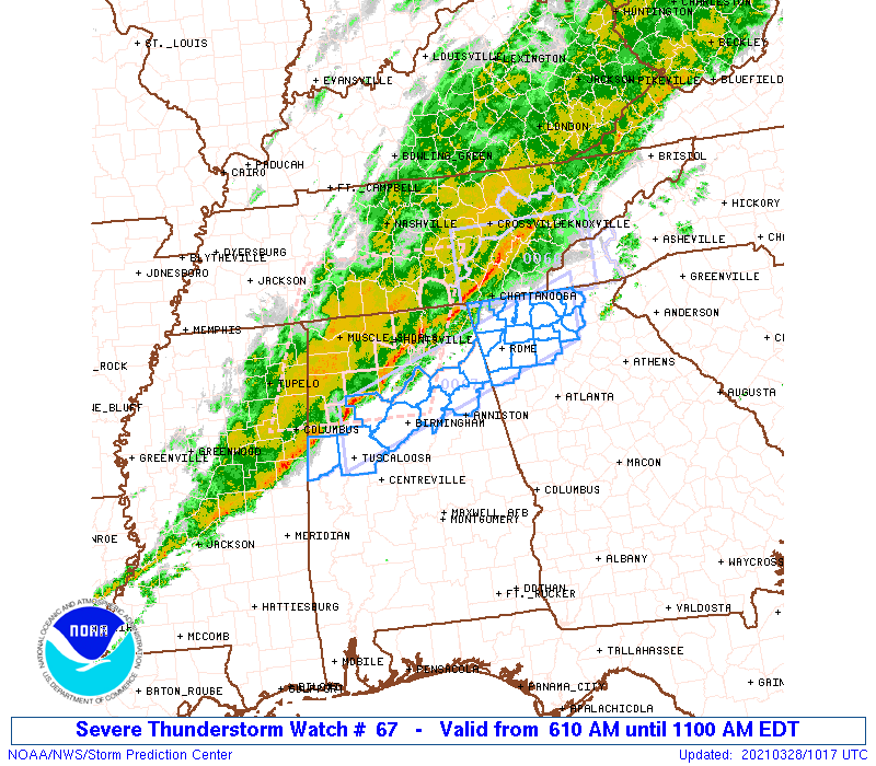
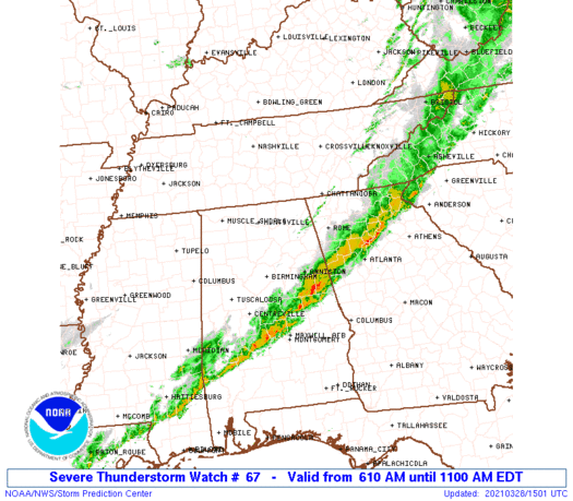
Severe Thunderstorm Watch Number 67
NWS Storm Prediction Center Norman OK
610 AM EDT Sun Mar 28 2021
The NWS Storm Prediction Center has issued a
* Severe Thunderstorm Watch for portions of
North-central/Northeast Alabama
Northern Georgia
* Effective this Sunday morning from 610 AM until 1100 AM EDT.
* Primary threats include...
Isolated damaging wind gusts to 65 mph possible
A tornado or two possible
SUMMARY...A broken cluster of storms will continue eastward through
the pre-dawn/early morning hours across north-central/northeast
Alabama into northwest/far northern Georgia. Isolated damaging winds
are the primary concern, but a brief tornado embedded within the
convective line cannot be ruled out.
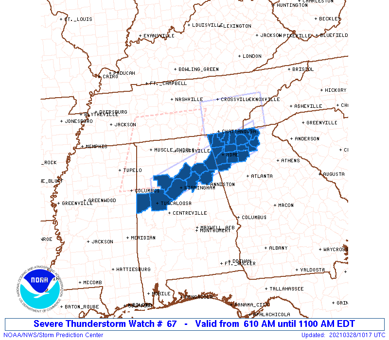
The severe thunderstorm watch area is approximately along and 30
statute miles north and south of a line from 20 miles north
northwest of Tuscaloosa AL to 75 miles east northeast of Rome GA.
For a complete depiction of the watch see the associated watch
outline update (WOUS64 KWNS WOU7).
PRECAUTIONARY/PREPAREDNESS ACTIONS...
REMEMBER...A Severe Thunderstorm Watch means conditions are
favorable for severe thunderstorms in and close to the watch area.
Persons in these areas should be on the lookout for threatening
weather conditions and listen for later statements and possible
warnings. Severe thunderstorms can and occasionally do produce
tornadoes.
&&
OTHER WATCH INFORMATION...CONTINUE...WW 65...WW 66...
AVIATION...A few severe thunderstorms with hail surface and aloft to
1 inch. Extreme turbulence and surface wind gusts to 55 knots. A few
cumulonimbi with maximum tops to 450. Mean storm motion vector
24030.
...Guyer

   SEL7

   URGENT - IMMEDIATE BROADCAST REQUESTED
   Severe Thunderstorm Watch Number 67
   NWS Storm Prediction Center Norman OK
   610 AM EDT Sun Mar 28 2021

   The NWS Storm Prediction Center has issued a

   * Severe Thunderstorm Watch for portions of
     North-central/Northeast Alabama
     Northern Georgia

   * Effective this Sunday morning from 610 AM until 1100 AM EDT.

   * Primary threats include...
     Isolated damaging wind gusts to 65 mph possible
     A tornado or two possible

   SUMMARY...A broken cluster of storms will continue eastward through
   the pre-dawn/early morning hours across north-central/northeast
   Alabama into northwest/far northern Georgia. Isolated damaging winds
   are the primary concern, but a brief tornado embedded within the
   convective line cannot be ruled out.

   The severe thunderstorm watch area is approximately along and 30
   statute miles north and south of a line from 20 miles north
   northwest of Tuscaloosa AL to 75 miles east northeast of Rome GA.
   For a complete depiction of the watch see the associated watch
   outline update (WOUS64 KWNS WOU7).

   PRECAUTIONARY/PREPAREDNESS ACTIONS...

   REMEMBER...A Severe Thunderstorm Watch means conditions are
   favorable for severe thunderstorms in and close to the watch area.
   Persons in these areas should be on the lookout for threatening
   weather conditions and listen for later statements and possible
   warnings. Severe thunderstorms can and occasionally do produce
   tornadoes.

   &&

   OTHER WATCH INFORMATION...CONTINUE...WW 65...WW 66...

   AVIATION...A few severe thunderstorms with hail surface and aloft to
   1 inch. Extreme turbulence and surface wind gusts to 55 knots. A few
   cumulonimbi with maximum tops to 450. Mean storm motion vector
   24030.

   ...Guyer
 Note:
The Aviation Watch (SAW) product is an approximation to the watch area.
The actual watch is depicted by the shaded areas.
Note:
The Aviation Watch (SAW) product is an approximation to the watch area.
The actual watch is depicted by the shaded areas.
   SAW7
   WW 67 SEVERE TSTM AL GA 281010Z - 281500Z
   AXIS..30 STATUTE MILES NORTH AND SOUTH OF LINE..
   20NNW TCL/TUSCALOOSA AL/ - 75ENE RMG/ROME GA/
   ..AVIATION COORDS.. 25NM N/S /38E IGB - 32W ODF/
   HAIL SURFACE AND ALOFT..1 INCH. WIND GUSTS..55 KNOTS.
   MAX TOPS TO 450. MEAN STORM MOTION VECTOR 24030.

   LAT...LON 33918775 35188395 34338395 33058775

   THIS IS AN APPROXIMATION TO THE WATCH AREA.  FOR A
   COMPLETE DEPICTION OF THE WATCH SEE WOUS64 KWNS
   FOR WOU7.
Watch 67 Status Report Messages:
STATUS REPORT #1 ON WW 67

VALID 281345Z - 281440Z

SEVERE WEATHER THREAT CONTINUES RIGHT OF A LINE FROM 40 S BHM TO
10 ESE ANB TO 25 SSW RMG TO 65 ENE RMG TO 50 S TYS.

FOR ADDITIONAL INFORMATION SEE MESOSCALE DISCUSSION 297

..GLEASON..03/28/21

ATTN...WFO...BMX...FFC...

&&

STATUS REPORT FOR WS 67

SEVERE WEATHER THREAT CONTINUES FOR THE FOLLOWING AREAS

ALC027-029-111-121-281440-

AL
.    ALABAMA COUNTIES INCLUDED ARE

CLAY		     CLEBURNE		 RANDOLPH
TALLADEGA
$$


GAC015-057-085-187-227-233-291-281440-

GA
.    GEORGIA COUNTIES INCLUDED ARE

BARTOW		     CHEROKEE		 DAWSON
LUMPKIN 	     PICKENS		 POLK
UNION
$$


THE WATCH STATUS MESSAGE IS FOR GUIDANCE PURPOSES ONLY.  PLEASE
REFER TO WATCH COUNTY NOTIFICATION STATEMENTS FOR OFFICIAL
INFORMATION ON COUNTIES...INDEPENDENT CITIES AND MARINE ZONES
CLEARED FROM SEVERE THUNDERSTORM AND TORNADO WATCHES.
$$
Note:
Click for Complete Product Text.
Tornadoes
Probability of 2 or more tornadoes
|
Low (20%)
|
Probability of 1 or more strong (EF2-EF5) tornadoes
|
Low (<2%)
|
Wind
Probability of 10 or more severe wind events
|
Mod (30%)
|
Probability of 1 or more wind events > 65 knots
|
Low (<5%)
|
Hail
Probability of 10 or more severe hail events
|
Low (<5%)
|
Probability of 1 or more hailstones > 2 inches
|
Low (<5%)
|
Combined Severe Hail/Wind
Probability of 6 or more combined severe hail/wind events
|
Mod (50%)
|
For each watch, probabilities for particular events inside the watch
(listed above in each table) are determined by the issuing forecaster.
The "Low" category contains probability values ranging from less than 2%
to 20% (EF2-EF5 tornadoes), less than 5% to 20% (all other probabilities),
"Moderate" from 30% to 60%, and "High" from 70% to greater than 95%.
High values are bolded and lighter in color to provide awareness of
an increased threat for a particular event.


 @NWSSPC