 Note:
The expiration time in the watch graphic is amended if the watch is
replaced, cancelled or extended.
Note:
Note:
The expiration time in the watch graphic is amended if the watch is
replaced, cancelled or extended.
Note: Click for
Watch Status Reports.
SEL6
URGENT - IMMEDIATE BROADCAST REQUESTED
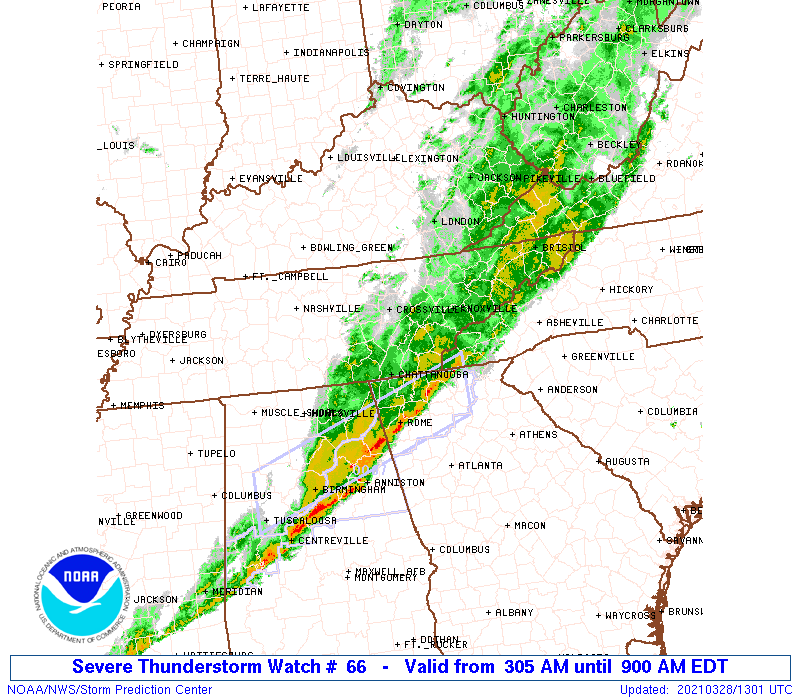
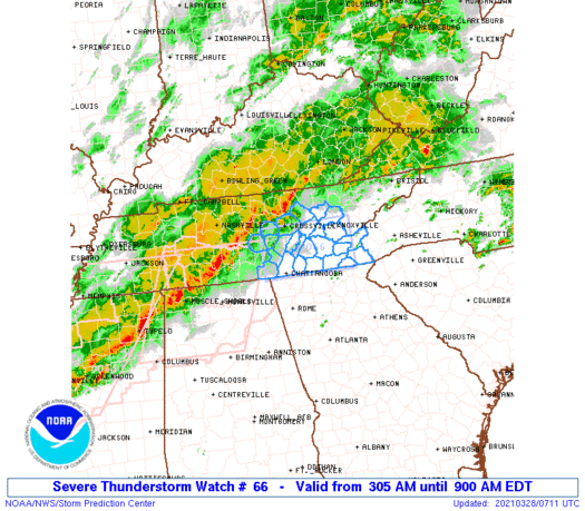
Severe Thunderstorm Watch Number 66
NWS Storm Prediction Center Norman OK
305 AM EDT Sun Mar 28 2021
The NWS Storm Prediction Center has issued a
* Severe Thunderstorm Watch for portions of
Western North Carolina
Eastern Tennessee
* Effective this Sunday morning from 305 AM until 900 AM EDT.
* Primary threats include...
Scattered damaging wind gusts to 70 mph possible
A tornado or two possible
SUMMARY...A well-organized band of storms will continue eastward
across eastern Tennessee into far western North Carolina through the
early morning. Isolated thunderstorm wind damage can be expected,
and a brief tornado risk cannot be entirely ruled out.
The severe thunderstorm watch area is approximately along and 35
statute miles north and south of a line from 35 miles southeast of
Knoxville TN to 40 miles northwest of Chattanooga TN. For a complete
depiction of the watch see the associated watch outline update
(WOUS64 KWNS WOU6).
PRECAUTIONARY/PREPAREDNESS ACTIONS...
REMEMBER...A Severe Thunderstorm Watch means conditions are
favorable for severe thunderstorms in and close to the watch area.
Persons in these areas should be on the lookout for threatening
weather conditions and listen for later statements and possible
warnings. Severe thunderstorms can and occasionally do produce
tornadoes.
&&
OTHER WATCH INFORMATION...CONTINUE...WW 64...WW 65...
AVIATION...A few severe thunderstorms with hail surface and aloft to
1 inch. Extreme turbulence and surface wind gusts to 60 knots. A few
cumulonimbi with maximum tops to 500. Mean storm motion vector
26035.
...Guyer
   SEL6

   URGENT - IMMEDIATE BROADCAST REQUESTED
   Severe Thunderstorm Watch Number 66
   NWS Storm Prediction Center Norman OK
   305 AM EDT Sun Mar 28 2021

   The NWS Storm Prediction Center has issued a

   * Severe Thunderstorm Watch for portions of
     Western North Carolina
     Eastern Tennessee

   * Effective this Sunday morning from 305 AM until 900 AM EDT.

   * Primary threats include...
     Scattered damaging wind gusts to 70 mph possible
     A tornado or two possible

   SUMMARY...A well-organized band of storms will continue eastward
   across eastern Tennessee into far western North Carolina through the
   early morning. Isolated thunderstorm wind damage can be expected,
   and a brief tornado risk cannot be entirely ruled out.

   The severe thunderstorm watch area is approximately along and 35
   statute miles north and south of a line from 35 miles southeast of
   Knoxville TN to 40 miles northwest of Chattanooga TN. For a complete
   depiction of the watch see the associated watch outline update
   (WOUS64 KWNS WOU6).

   PRECAUTIONARY/PREPAREDNESS ACTIONS...

   REMEMBER...A Severe Thunderstorm Watch means conditions are
   favorable for severe thunderstorms in and close to the watch area.
   Persons in these areas should be on the lookout for threatening
   weather conditions and listen for later statements and possible
   warnings. Severe thunderstorms can and occasionally do produce
   tornadoes.

   &&

   OTHER WATCH INFORMATION...CONTINUE...WW 64...WW 65...

   AVIATION...A few severe thunderstorms with hail surface and aloft to
   1 inch. Extreme turbulence and surface wind gusts to 60 knots. A few
   cumulonimbi with maximum tops to 500. Mean storm motion vector
   26035.

   ...Guyer
 Note:
The Aviation Watch (SAW) product is an approximation to the watch area.
The actual watch is depicted by the shaded areas.
Note:
The Aviation Watch (SAW) product is an approximation to the watch area.
The actual watch is depicted by the shaded areas.
   SAW6
   WW 66 SEVERE TSTM NC TN 280705Z - 281300Z
   AXIS..35 STATUTE MILES NORTH AND SOUTH OF LINE..
   35SE TYS/KNOXVILLE TN/ - 40NW CHA/CHATTANOOGA TN/
   ..AVIATION COORDS.. 30NM N/S /31SSE VXV - 39NW GQO/
   HAIL SURFACE AND ALOFT..1 INCH. WIND GUSTS..60 KNOTS.
   MAX TOPS TO 500. MEAN STORM MOTION VECTOR 26035.

   LAT...LON 34958356 34938570 35938570 35978356

   THIS IS AN APPROXIMATION TO THE WATCH AREA.  FOR A
   COMPLETE DEPICTION OF THE WATCH SEE WOUS64 KWNS
   FOR WOU6.
Watch 66 Status Report Message has not been issued yet.
Note:
Click for Complete Product Text.
Tornadoes
Probability of 2 or more tornadoes
|
Low (20%)
|
Probability of 1 or more strong (EF2-EF5) tornadoes
|
Low (5%)
|
Wind
Probability of 10 or more severe wind events
|
Mod (40%)
|
Probability of 1 or more wind events > 65 knots
|
Low (<5%)
|
Hail
Probability of 10 or more severe hail events
|
Low (10%)
|
Probability of 1 or more hailstones > 2 inches
|
Low (<5%)
|
Combined Severe Hail/Wind
Probability of 6 or more combined severe hail/wind events
|
High (70%)
|
For each watch, probabilities for particular events inside the watch
(listed above in each table) are determined by the issuing forecaster.
The "Low" category contains probability values ranging from less than 2%
to 20% (EF2-EF5 tornadoes), less than 5% to 20% (all other probabilities),
"Moderate" from 30% to 60%, and "High" from 70% to greater than 95%.
High values are bolded and lighter in color to provide awareness of
an increased threat for a particular event.


 @NWSSPC