 Note:
The expiration time in the watch graphic is amended if the watch is
replaced, cancelled or extended.
Note:
Note:
The expiration time in the watch graphic is amended if the watch is
replaced, cancelled or extended.
Note: Click for
Watch Status Reports.
SEL8
URGENT - IMMEDIATE BROADCAST REQUESTED
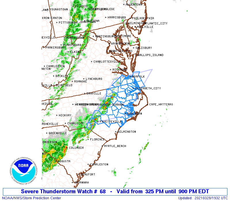
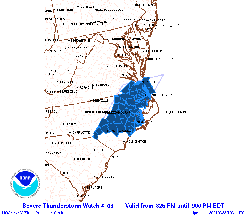
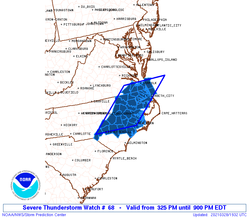
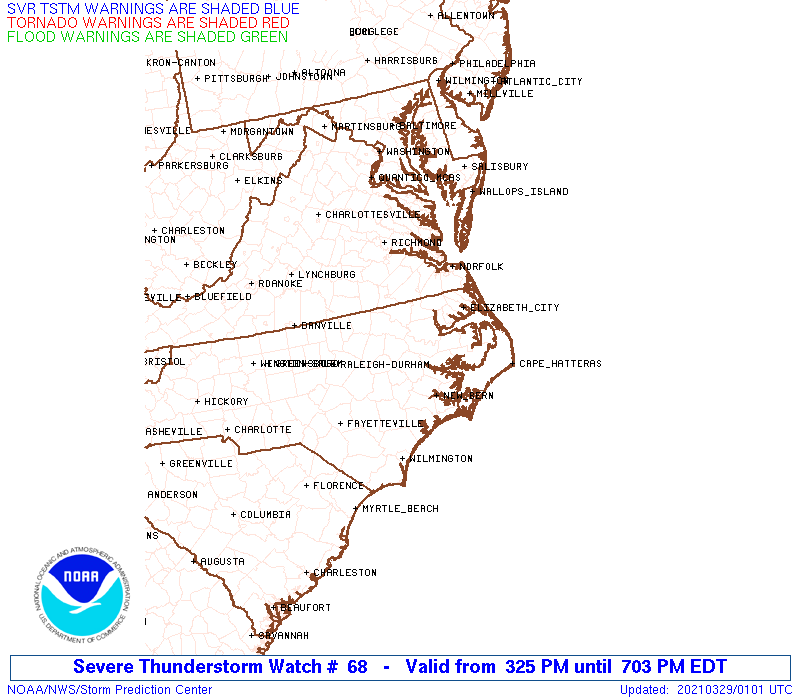
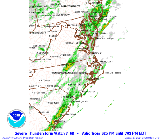
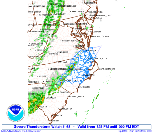
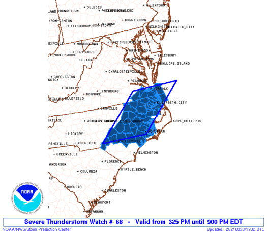
Severe Thunderstorm Watch Number 68
NWS Storm Prediction Center Norman OK
325 PM EDT Sun Mar 28 2021
The NWS Storm Prediction Center has issued a
* Severe Thunderstorm Watch for portions of
East central and northeast North Carolina
Southeast Virginia
Coastal Waters
* Effective this Sunday afternoon and evening from 325 PM until
900 PM EDT.
* Primary threats include...
Scattered damaging wind gusts to 70 mph possible
Isolated large hail events to 1 inch in diameter possible
A tornado or two possible
SUMMARY...Scattered thunderstorms have developed along a pre-frontal
trough across North Carolina, and additional storms may form along a
sea breeze boundary farther to the east. The storms will spread
northeastward toward southeast Virginia and will be capable of
producing damaging winds, as well as an isolated tornado and
marginally severe hail through this evening.
The severe thunderstorm watch area is approximately along and 70
statute miles east and west of a line from 35 miles east of
Fayetteville NC to 15 miles east northeast of Norfolk VA. For a
complete depiction of the watch see the associated watch outline
update (WOUS64 KWNS WOU8).
PRECAUTIONARY/PREPAREDNESS ACTIONS...
REMEMBER...A Severe Thunderstorm Watch means conditions are
favorable for severe thunderstorms in and close to the watch area.
Persons in these areas should be on the lookout for threatening
weather conditions and listen for later statements and possible
warnings. Severe thunderstorms can and occasionally do produce
tornadoes.
&&
AVIATION...A few severe thunderstorms with hail surface and aloft to
1 inch. Extreme turbulence and surface wind gusts to 60 knots. A few
cumulonimbi with maximum tops to 500. Mean storm motion vector
24045.
...Thompson
   SEL8

   URGENT - IMMEDIATE BROADCAST REQUESTED
   Severe Thunderstorm Watch Number 68
   NWS Storm Prediction Center Norman OK
   325 PM EDT Sun Mar 28 2021

   The NWS Storm Prediction Center has issued a

   * Severe Thunderstorm Watch for portions of
     East central and northeast North Carolina
     Southeast Virginia
     Coastal Waters

   * Effective this Sunday afternoon and evening from 325 PM until
     900 PM EDT.

   * Primary threats include...
     Scattered damaging wind gusts to 70 mph possible
     Isolated large hail events to 1 inch in diameter possible
     A tornado or two possible

   SUMMARY...Scattered thunderstorms have developed along a pre-frontal
   trough across North Carolina, and additional storms may form along a
   sea breeze boundary farther to the east.  The storms will spread
   northeastward toward southeast Virginia and will be capable of
   producing damaging winds, as well as an isolated tornado and
   marginally severe hail through this evening.

   The severe thunderstorm watch area is approximately along and 70
   statute miles east and west of a line from 35 miles east of
   Fayetteville NC to 15 miles east northeast of Norfolk VA. For a
   complete depiction of the watch see the associated watch outline
   update (WOUS64 KWNS WOU8).

   PRECAUTIONARY/PREPAREDNESS ACTIONS...

   REMEMBER...A Severe Thunderstorm Watch means conditions are
   favorable for severe thunderstorms in and close to the watch area.
   Persons in these areas should be on the lookout for threatening
   weather conditions and listen for later statements and possible
   warnings. Severe thunderstorms can and occasionally do produce
   tornadoes.

   &&

   AVIATION...A few severe thunderstorms with hail surface and aloft to
   1 inch. Extreme turbulence and surface wind gusts to 60 knots. A few
   cumulonimbi with maximum tops to 500. Mean storm motion vector
   24045.

   ...Thompson
 Note:
The Aviation Watch (SAW) product is an approximation to the watch area.
The actual watch is depicted by the shaded areas.
Note:
The Aviation Watch (SAW) product is an approximation to the watch area.
The actual watch is depicted by the shaded areas.
   SAW8
   WW 68 SEVERE TSTM NC VA CW 281925Z - 290100Z
   AXIS..70 STATUTE MILES EAST AND WEST OF LINE..
   35E FAY/FAYETTEVILLE NC/ - 15ENE ORF/NORFOLK VA/
   ..AVIATION COORDS.. 60NM E/W /42NNW ILM - 13ENE ORF/
   HAIL SURFACE AND ALOFT..1 INCH. WIND GUSTS..60 KNOTS.
   MAX TOPS TO 500. MEAN STORM MOTION VECTOR 24045.

   LAT...LON 34967950 36987722 36987468 34967703

   THIS IS AN APPROXIMATION TO THE WATCH AREA.  FOR A
   COMPLETE DEPICTION OF THE WATCH SEE WOUS64 KWNS
   FOR WOU8.
Watch 68 Status Report Messages:
STATUS REPORT #2 ON WW 68

VALID 282140Z - 282240Z

SEVERE WEATHER THREAT CONTINUES RIGHT OF A LINE FROM 25 E FAY TO
15 SW GSB TO 30 E RWI TO 40 SE RZZ TO 30 SW ORF TO 25 NNW ORF.

..JEWELL..03/28/21

ATTN...WFO...MHX...AKQ...RAH...

&&

STATUS REPORT FOR WS 68

SEVERE WEATHER THREAT CONTINUES FOR THE FOLLOWING AREAS

NCC013-015-029-041-049-053-061-079-103-107-117-133-137-139-143-
147-177-187-282240-

NC
.    NORTH CAROLINA COUNTIES INCLUDED ARE

BEAUFORT	     BERTIE		 CAMDEN
CHOWAN		     CRAVEN		 CURRITUCK
DUPLIN		     GREENE		 JONES
LENOIR		     MARTIN		 ONSLOW
PAMLICO 	     PASQUOTANK 	 PERQUIMANS
PITT		     TYRRELL		 WASHINGTON
$$


VAC550-710-740-810-282240-

VA
.    VIRGINIA COUNTIES INCLUDED ARE


VIRGINIA INDEPENDENT CITIES INCLUDED ARE

CHESAPEAKE	     NORFOLK		 PORTSMOUTH
VIRGINIA BEACH
$$


AMZ136-137-230-ANZ633-656-658-282240-

CW

.    ADJACENT COASTAL WATERS INCLUDED ARE

PAMLICO AND PUNGO RIVERS

NEUSE AND BAY RIVERS

ALBEMARLE SOUND

CURRITUCK SOUND

COASTAL WATERS FROM CAPE CHARLES LIGHT TO VIRGINIA-NORTH CAROLINA
BORDER OUT TO 20 NM

COASTAL WATERS FROM NC VA BORDER TO CURRITUCK BEACH LIGHT NC OUT
20 NM

$$
THE WATCH STATUS MESSAGE IS FOR GUIDANCE PURPOSES ONLY.  PLEASE
REFER TO WATCH COUNTY NOTIFICATION STATEMENTS FOR OFFICIAL
INFORMATION ON COUNTIES...INDEPENDENT CITIES AND MARINE ZONES
CLEARED FROM SEVERE THUNDERSTORM AND TORNADO WATCHES.
$$

STATUS REPORT #1 ON WW 68

VALID 282055Z - 282140Z

SEVERE WEATHER THREAT CONTINUES RIGHT OF A LINE FROM 25 E FAY TO
10 NE GSB TO 40 SE RZZ TO 35 NW ECG TO 20 NW ORF.

FOR ADDITIONAL INFORMATION SEE MESOSCALE DISCUSSION 301

..LYONS..03/28/21

ATTN...WFO...MHX...AKQ...RAH...

&&

STATUS REPORT FOR WS 68

SEVERE WEATHER THREAT CONTINUES FOR THE FOLLOWING AREAS

NCC013-015-029-041-049-053-061-073-079-103-107-117-133-137-139-
143-147-177-187-282140-

NC
.    NORTH CAROLINA COUNTIES INCLUDED ARE

BEAUFORT	     BERTIE		 CAMDEN
CHOWAN		     CRAVEN		 CURRITUCK
DUPLIN		     GATES		 GREENE
JONES		     LENOIR		 MARTIN
ONSLOW		     PAMLICO		 PASQUOTANK
PERQUIMANS	     PITT		 TYRRELL
WASHINGTON
$$


VAC550-710-740-810-282140-

VA
.    VIRGINIA COUNTIES INCLUDED ARE


VIRGINIA INDEPENDENT CITIES INCLUDED ARE

CHESAPEAKE	     NORFOLK		 PORTSMOUTH
VIRGINIA BEACH
$$


AMZ136-137-230-ANZ633-656-658-282140-

CW

.    ADJACENT COASTAL WATERS INCLUDED ARE

PAMLICO AND PUNGO RIVERS

NEUSE AND BAY RIVERS

ALBEMARLE SOUND

CURRITUCK SOUND

COASTAL WATERS FROM CAPE CHARLES LIGHT TO VIRGINIA-NORTH CAROLINA
BORDER OUT TO 20 NM

COASTAL WATERS FROM NC VA BORDER TO CURRITUCK BEACH LIGHT NC OUT
20 NM

$$
THE WATCH STATUS MESSAGE IS FOR GUIDANCE PURPOSES ONLY.  PLEASE
REFER TO WATCH COUNTY NOTIFICATION STATEMENTS FOR OFFICIAL
INFORMATION ON COUNTIES...INDEPENDENT CITIES AND MARINE ZONES
CLEARED FROM SEVERE THUNDERSTORM AND TORNADO WATCHES.
$$
Note:
Click for Complete Product Text.
Tornadoes
Probability of 2 or more tornadoes
|
Low (20%)
|
Probability of 1 or more strong (EF2-EF5) tornadoes
|
Low (5%)
|
Wind
Probability of 10 or more severe wind events
|
Mod (50%)
|
Probability of 1 or more wind events > 65 knots
|
Low (20%)
|
Hail
Probability of 10 or more severe hail events
|
Low (20%)
|
Probability of 1 or more hailstones > 2 inches
|
Low (10%)
|
Combined Severe Hail/Wind
Probability of 6 or more combined severe hail/wind events
|
High (70%)
|
For each watch, probabilities for particular events inside the watch
(listed above in each table) are determined by the issuing forecaster.
The "Low" category contains probability values ranging from less than 2%
to 20% (EF2-EF5 tornadoes), less than 5% to 20% (all other probabilities),
"Moderate" from 30% to 60%, and "High" from 70% to greater than 95%.
High values are bolded and lighter in color to provide awareness of
an increased threat for a particular event.


 @NWSSPC