 Note:
The expiration time in the watch graphic is amended if the watch is
replaced, cancelled or extended.
Note:
Note:
The expiration time in the watch graphic is amended if the watch is
replaced, cancelled or extended.
Note: Click for
Watch Status Reports.
SEL2
URGENT - IMMEDIATE BROADCAST REQUESTED
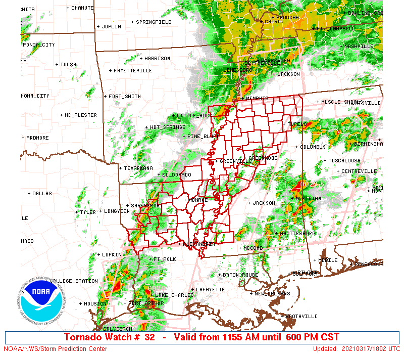
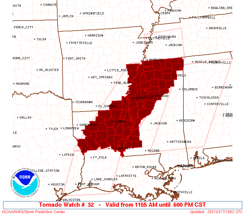
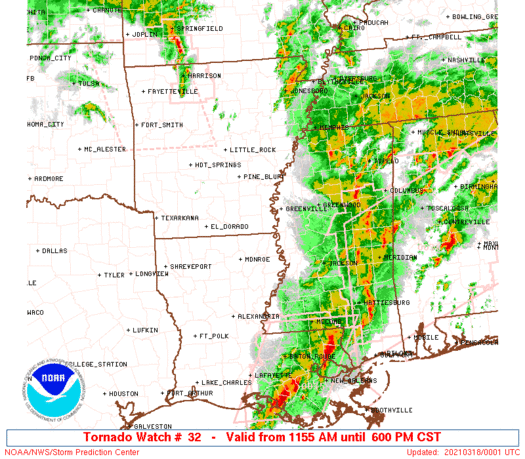
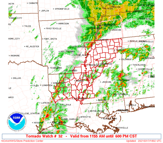
Tornado Watch Number 32
NWS Storm Prediction Center Norman OK
1155 AM CST Wed Mar 17 2021
The NWS Storm Prediction Center has issued a
* Tornado Watch for portions of
Southeast Arkansas
Northern Louisiana
Northern and western Mississippi
* Effective this Wednesday morning and evening from 1155 AM until
600 PM CST.
...THIS IS A PARTICULARLY DANGEROUS SITUATION...
* Primary threats include...
Several tornadoes and a few intense tornadoes likely
Widespread damaging winds and scattered significant gusts to 85
mph likely
Scattered large hail likely with isolated very large hail events
to 2.5 inches in diameter possible
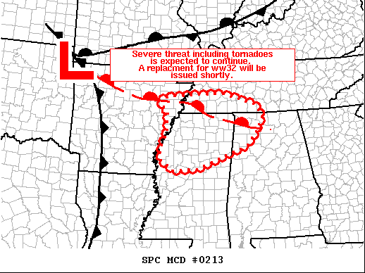
SUMMARY...Discrete supercells and linear clusters are expected to
intensify and becoming increasingly widespread across the
Ark-La-Miss region through this evening. At least a few significant
tornadoes are expected, one or more of which may become
long-tracked.
The tornado watch area is approximately along and 80 statute miles
east and west of a line from 40 miles north of Oxford MS to 25 miles
west of Alexandria LA. For a complete depiction of the watch see the
associated watch outline update (WOUS64 KWNS WOU2).
PRECAUTIONARY/PREPAREDNESS ACTIONS...
REMEMBER...A Tornado Watch means conditions are favorable for
tornadoes and severe thunderstorms in and close to the watch
area. Persons in these areas should be on the lookout for
threatening weather conditions and listen for later statements
and possible warnings.
&&
OTHER WATCH INFORMATION...CONTINUE...WW 26...WW 27...WW 28...WW
29...WW 30...WW 31...
AVIATION...Tornadoes and a few severe thunderstorms with hail
surface and aloft to 2.5 inches. Extreme turbulence and surface wind
gusts to 75 knots. A few cumulonimbi with maximum tops to 500. Mean
storm motion vector 24035.
...Grams
   SEL2

   URGENT - IMMEDIATE BROADCAST REQUESTED
   Tornado Watch Number 32
   NWS Storm Prediction Center Norman OK
   1155 AM CST Wed Mar 17 2021

   The NWS Storm Prediction Center has issued a

   * Tornado Watch for portions of
     Southeast Arkansas
     Northern Louisiana
     Northern and western Mississippi

   * Effective this Wednesday morning and evening from 1155 AM until
     600 PM CST.

   ...THIS IS A PARTICULARLY DANGEROUS SITUATION...

   * Primary threats include...
     Several tornadoes and a few intense tornadoes likely
     Widespread damaging winds and scattered significant gusts to 85
       mph likely
     Scattered large hail likely with isolated very large hail events
       to 2.5 inches in diameter possible

   SUMMARY...Discrete supercells and linear clusters are expected to
   intensify and becoming increasingly widespread across the
   Ark-La-Miss region through this evening. At least a few significant
   tornadoes are expected, one or more of which may become
   long-tracked.

   The tornado watch area is approximately along and 80 statute miles
   east and west of a line from 40 miles north of Oxford MS to 25 miles
   west of Alexandria LA. For a complete depiction of the watch see the
   associated watch outline update (WOUS64 KWNS WOU2).

   PRECAUTIONARY/PREPAREDNESS ACTIONS...

   REMEMBER...A Tornado Watch means conditions are favorable for
   tornadoes and severe thunderstorms in and close to the watch
   area. Persons in these areas should be on the lookout for
   threatening weather conditions and listen for later statements
   and possible warnings.

   &&

   OTHER WATCH INFORMATION...CONTINUE...WW 26...WW 27...WW 28...WW
   29...WW 30...WW 31...

   AVIATION...Tornadoes and a few severe thunderstorms with hail
   surface and aloft to 2.5 inches. Extreme turbulence and surface wind
   gusts to 75 knots. A few cumulonimbi with maximum tops to 500. Mean
   storm motion vector 24035.

   ...Grams
 Note:
The Aviation Watch (SAW) product is an approximation to the watch area.
The actual watch is depicted by the shaded areas.
Note:
The Aviation Watch (SAW) product is an approximation to the watch area.
The actual watch is depicted by the shaded areas.
SAW2
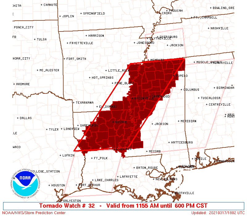
WW 32 TORNADO AR LA MS 171755Z - 180000Z
AXIS..80 STATUTE MILES EAST AND WEST OF LINE..
40N UOX/OXFORD MS/ - 25W ESF/ALEXANDRIA LA/
..AVIATION COORDS.. 70NM E/W /23ESE MEM - 14NW AEX/
HAIL SURFACE AND ALOFT..2.5 INCHES. WIND GUSTS..75 KNOTS.
MAX TOPS TO 500. MEAN STORM MOTION VECTOR 24035.
LAT...LON 34958812 31399137 31399408 34959094
THIS IS AN APPROXIMATION TO THE WATCH AREA. FOR A
COMPLETE DEPICTION OF THE WATCH SEE WOUS64 KWNS
FOR WOU2.
Watch 32 Status Report Messages:
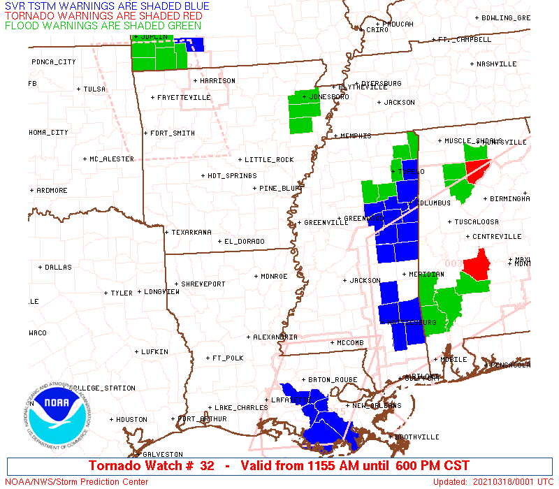
STATUS REPORT #3 ON WW 32

VALID 172255Z - 172340Z

SEVERE WEATHER THREAT CONTINUES RIGHT OF A LINE FROM 30 E ESF TO
35 NE MLU TO 40 E PBF TO 45 ENE LIT.

..LYONS..03/17/21

ATTN...WFO...JAN...MEG...SHV...

&&

STATUS REPORT FOR WT 32

SEVERE WEATHER THREAT CONTINUES FOR THE FOLLOWING AREAS

ARC017-077-107-172340-

AR
.    ARKANSAS COUNTIES INCLUDED ARE

CHICOT		     LEE		 PHILLIPS
$$


LAC035-065-107-172340-

LA
.    LOUISIANA PARISHES INCLUDED ARE

EAST CARROLL	     MADISON		 TENSAS
$$


MSC001-003-009-011-013-015-017-021-027-033-037-043-051-053-055-
063-071-081-083-093-097-107-115-117-119-125-133-135-137-139-141-
143-145-149-151-155-161-163-172340-

MS
.    MISSISSIPPI COUNTIES INCLUDED ARE

ADAMS		     ALCORN		 BENTON
BOLIVAR 	     CALHOUN		 CARROLL
CHICKASAW	     CLAIBORNE		 COAHOMA
DESOTO		     FRANKLIN		 GRENADA
HOLMES		     HUMPHREYS		 ISSAQUENA
JEFFERSON	     LAFAYETTE		 LEE
LEFLORE 	     MARSHALL		 MONTGOMERY
PANOLA		     PONTOTOC		 PRENTISS
QUITMAN 	     SHARKEY		 SUNFLOWER
TALLAHATCHIE	     TATE		 TIPPAH
TISHOMINGO	     TUNICA		 UNION
WARREN		     WASHINGTON 	 WEBSTER
YALOBUSHA	     YAZOO
$$


THE WATCH STATUS MESSAGE IS FOR GUIDANCE PURPOSES ONLY.  PLEASE
REFER TO WATCH COUNTY NOTIFICATION STATEMENTS FOR OFFICIAL
INFORMATION ON COUNTIES...INDEPENDENT CITIES AND MARINE ZONES
CLEARED FROM SEVERE THUNDERSTORM AND TORNADO WATCHES.
$$

STATUS REPORT #2 ON WW 32

VALID 172055Z - 172140Z

SEVERE WEATHER THREAT CONTINUES RIGHT OF A LINE FROM 15 N POE TO
15 NE IER TO 25 W MLU TO 25 SW PBF.

FOR ADDITIONAL INFORMATION SEE MESOSCALE DISCUSSION 210

..BENTLEY..03/17/21

ATTN...WFO...JAN...MEG...SHV...

&&

STATUS REPORT FOR WT 32

SEVERE WEATHER THREAT CONTINUES FOR THE FOLLOWING AREAS

ARC003-017-077-107-172140-

AR
.    ARKANSAS COUNTIES INCLUDED ARE

ASHLEY		     CHICOT		 LEE
PHILLIPS
$$


LAC021-025-029-035-041-043-049-059-061-065-067-069-073-083-107-
111-123-127-172140-

LA
.    LOUISIANA PARISHES INCLUDED ARE

CALDWELL	     CATAHOULA		 CONCORDIA
EAST CARROLL	     FRANKLIN		 GRANT
JACKSON 	     LA SALLE		 LINCOLN
MADISON 	     MOREHOUSE		 NATCHITOCHES
OUACHITA	     RICHLAND		 TENSAS
UNION		     WEST CARROLL	 WINN
$$


MSC001-003-009-011-013-015-017-021-027-033-037-043-051-053-055-
063-071-081-083-093-097-107-115-117-119-125-133-135-137-139-141-
143-145-149-151-155-161-163-172140-

MS
.    MISSISSIPPI COUNTIES INCLUDED ARE

ADAMS		     ALCORN		 BENTON
BOLIVAR 	     CALHOUN		 CARROLL
CHICKASAW	     CLAIBORNE		 COAHOMA
DESOTO		     FRANKLIN		 GRENADA
HOLMES		     HUMPHREYS		 ISSAQUENA
JEFFERSON	     LAFAYETTE		 LEE
LEFLORE 	     MARSHALL		 MONTGOMERY
PANOLA		     PONTOTOC		 PRENTISS
QUITMAN 	     SHARKEY		 SUNFLOWER
TALLAHATCHIE	     TATE		 TIPPAH
TISHOMINGO	     TUNICA		 UNION
WARREN		     WASHINGTON 	 WEBSTER
YALOBUSHA	     YAZOO
$$


THE WATCH STATUS MESSAGE IS FOR GUIDANCE PURPOSES ONLY.  PLEASE
REFER TO WATCH COUNTY NOTIFICATION STATEMENTS FOR OFFICIAL
INFORMATION ON COUNTIES...INDEPENDENT CITIES AND MARINE ZONES
CLEARED FROM SEVERE THUNDERSTORM AND TORNADO WATCHES.
$$

STATUS REPORT #1 ON WW 32

VALID 171935Z - 172040Z

THE SEVERE WEATHER THREAT CONTINUES ACROSS THE ENTIRE WATCH AREA.

..BENTLEY..03/17/21

ATTN...WFO...JAN...MEG...SHV...

&&

STATUS REPORT FOR WT 32

SEVERE WEATHER THREAT CONTINUES FOR THE FOLLOWING AREAS

ARC003-017-077-107-172040-

AR
.    ARKANSAS COUNTIES INCLUDED ARE

ASHLEY		     CHICOT		 LEE
PHILLIPS
$$


LAC013-021-025-029-035-041-043-049-059-061-065-067-069-073-081-
083-085-107-111-123-127-172040-

LA
.    LOUISIANA PARISHES INCLUDED ARE

BIENVILLE	     CALDWELL		 CATAHOULA
CONCORDIA	     EAST CARROLL	 FRANKLIN
GRANT		     JACKSON		 LA SALLE
LINCOLN 	     MADISON		 MOREHOUSE
NATCHITOCHES	     OUACHITA		 RED RIVER
RICHLAND	     SABINE		 TENSAS
UNION		     WEST CARROLL	 WINN
$$


MSC001-003-009-011-013-015-017-021-027-033-037-043-051-053-055-
063-071-081-083-093-097-107-115-117-119-125-133-135-137-139-141-
143-145-149-151-155-161-163-172040-

MS
.    MISSISSIPPI COUNTIES INCLUDED ARE

ADAMS		     ALCORN		 BENTON
BOLIVAR 	     CALHOUN		 CARROLL
CHICKASAW	     CLAIBORNE		 COAHOMA
DESOTO		     FRANKLIN		 GRENADA
HOLMES		     HUMPHREYS		 ISSAQUENA
JEFFERSON	     LAFAYETTE		 LEE
LEFLORE 	     MARSHALL		 MONTGOMERY
PANOLA		     PONTOTOC		 PRENTISS
QUITMAN 	     SHARKEY		 SUNFLOWER
TALLAHATCHIE	     TATE		 TIPPAH
TISHOMINGO	     TUNICA		 UNION
WARREN		     WASHINGTON 	 WEBSTER
YALOBUSHA	     YAZOO
$$


THE WATCH STATUS MESSAGE IS FOR GUIDANCE PURPOSES ONLY.  PLEASE
REFER TO WATCH COUNTY NOTIFICATION STATEMENTS FOR OFFICIAL
INFORMATION ON COUNTIES...INDEPENDENT CITIES AND MARINE ZONES
CLEARED FROM SEVERE THUNDERSTORM AND TORNADO WATCHES.
$$
Note:
Click for Complete Product Text.
Tornadoes
Probability of 2 or more tornadoes
|
High (90%)
|
Probability of 1 or more strong (EF2-EF5) tornadoes
|
High (80%)
|
Wind
Probability of 10 or more severe wind events
|
High (80%)
|
Probability of 1 or more wind events > 65 knots
|
High (80%)
|
Hail
Probability of 10 or more severe hail events
|
Mod (60%)
|
Probability of 1 or more hailstones > 2 inches
|
Mod (50%)
|
Combined Severe Hail/Wind
Probability of 6 or more combined severe hail/wind events
|
High (>95%)
|
For each watch, probabilities for particular events inside the watch
(listed above in each table) are determined by the issuing forecaster.
The "Low" category contains probability values ranging from less than 2%
to 20% (EF2-EF5 tornadoes), less than 5% to 20% (all other probabilities),
"Moderate" from 30% to 60%, and "High" from 70% to greater than 95%.
High values are bolded and lighter in color to provide awareness of
an increased threat for a particular event.


 @NWSSPC