Note:
The expiration time in the watch graphic is amended if the watch is
replaced, cancelled or extended.
Note:
Note:
The expiration time in the watch graphic is amended if the watch is
replaced, cancelled or extended.
Note: Click for
Watch Status Reports.
SEL4
URGENT - IMMEDIATE BROADCAST REQUESTED
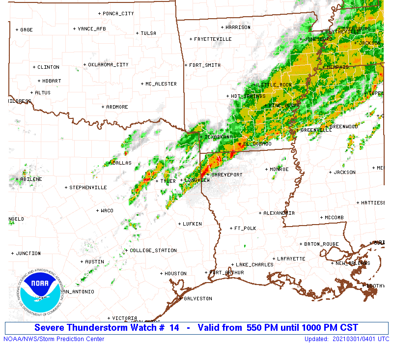
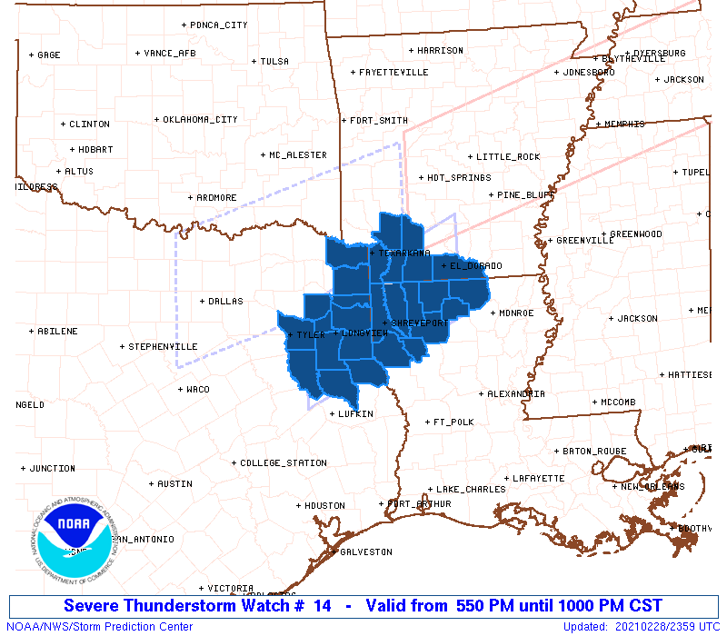
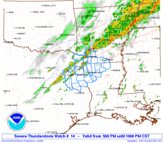
Severe Thunderstorm Watch Number 14
NWS Storm Prediction Center Norman OK
550 PM CST Sun Feb 28 2021
The NWS Storm Prediction Center has issued a
* Severe Thunderstorm Watch for portions of
Southwest Arkansas
Northwest Louisiana
Northeast Texas
* Effective this Sunday afternoon and evening from 550 PM until
1000 PM CST.
* Primary threats include...
Isolated damaging wind gusts to 65 mph possible
Isolated large hail events to 1.5 inches in diameter possible
A tornado or two possible
SUMMARY...Multiple discrete cells should persist along a cold front
that will shift southeast this evening, and may consolidate into a
cluster across the Arklatex region. Large hail and damaging winds
should be the primary threats.
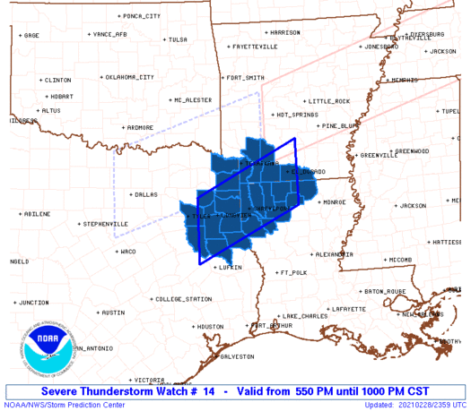
The severe thunderstorm watch area is approximately along and 50
statute miles north and south of a line from 15 miles east of El
Dorado AR to 35 miles southwest of Longview TX. For a complete
depiction of the watch see the associated watch outline update
(WOUS64 KWNS WOU4).
PRECAUTIONARY/PREPAREDNESS ACTIONS...
REMEMBER...A Severe Thunderstorm Watch means conditions are
favorable for severe thunderstorms in and close to the watch area.
Persons in these areas should be on the lookout for threatening
weather conditions and listen for later statements and possible
warnings. Severe thunderstorms can and occasionally do produce
tornadoes.
&&
OTHER WATCH INFORMATION...CONTINUE...WW 12...WW 13...
AVIATION...A few severe thunderstorms with hail surface and aloft to
1.5 inches. Extreme turbulence and surface wind gusts to 55 knots. A
few cumulonimbi with maximum tops to 500. Mean storm motion vector
23030.
...Grams
   SEL4

   URGENT - IMMEDIATE BROADCAST REQUESTED
   Severe Thunderstorm Watch Number 14
   NWS Storm Prediction Center Norman OK
   550 PM CST Sun Feb 28 2021

   The NWS Storm Prediction Center has issued a

   * Severe Thunderstorm Watch for portions of
     Southwest Arkansas
     Northwest Louisiana
     Northeast Texas

   * Effective this Sunday afternoon and evening from 550 PM until
     1000 PM CST.

   * Primary threats include...
     Isolated damaging wind gusts to 65 mph possible
     Isolated large hail events to 1.5 inches in diameter possible
     A tornado or two possible

   SUMMARY...Multiple discrete cells should persist along a cold front
   that will shift southeast this evening, and may consolidate into a
   cluster across the Arklatex region. Large hail and damaging winds
   should be the primary threats.

   The severe thunderstorm watch area is approximately along and 50
   statute miles north and south of a line from 15 miles east of El
   Dorado AR to 35 miles southwest of Longview TX. For a complete
   depiction of the watch see the associated watch outline update
   (WOUS64 KWNS WOU4).

   PRECAUTIONARY/PREPAREDNESS ACTIONS...

   REMEMBER...A Severe Thunderstorm Watch means conditions are
   favorable for severe thunderstorms in and close to the watch area.
   Persons in these areas should be on the lookout for threatening
   weather conditions and listen for later statements and possible
   warnings. Severe thunderstorms can and occasionally do produce
   tornadoes.

   &&

   OTHER WATCH INFORMATION...CONTINUE...WW 12...WW 13...

   AVIATION...A few severe thunderstorms with hail surface and aloft to
   1.5 inches. Extreme turbulence and surface wind gusts to 55 knots. A
   few cumulonimbi with maximum tops to 500. Mean storm motion vector
   23030.

   ...Grams
 Note:
The Aviation Watch (SAW) product is an approximation to the watch area.
The actual watch is depicted by the shaded areas.
Note:
The Aviation Watch (SAW) product is an approximation to the watch area.
The actual watch is depicted by the shaded areas.
   SAW4
   WW 14 SEVERE TSTM AR LA TX 282350Z - 010400Z
   AXIS..50 STATUTE MILES NORTH AND SOUTH OF LINE..
   15E ELD/EL DORADO AR/ - 35SW GGG/LONGVIEW TX/
   ..AVIATION COORDS.. 45NM N/S /9ESE ELD - 31SW GGG/
   HAIL SURFACE AND ALOFT..1.5 INCHES. WIND GUSTS..55 KNOTS.
   MAX TOPS TO 500. MEAN STORM MOTION VECTOR 23030.

   LAT...LON 32509256 31309514 32749514 33939256

   THIS IS AN APPROXIMATION TO THE WATCH AREA.  FOR A
   COMPLETE DEPICTION OF THE WATCH SEE WOUS64 KWNS
   FOR WOU4.
Watch 14 Status Report Messages:
STATUS REPORT #2 ON WW 14

VALID 010340Z - 010440Z

THE SEVERE WEATHER THREAT CONTINUES ACROSS THE ENTIRE WATCH AREA.

..BROYLES..03/01/21

ATTN...WFO...SHV...

&&

STATUS REPORT FOR WS 14

SEVERE WEATHER THREAT CONTINUES FOR THE FOLLOWING AREAS

ARC027-057-073-091-099-139-010440-

AR
.    ARKANSAS COUNTIES INCLUDED ARE

COLUMBIA	     HEMPSTEAD		 LAFAYETTE
MILLER		     NEVADA		 UNION
$$


LAC013-015-017-027-031-061-081-111-119-010440-

LA
.    LOUISIANA PARISHES INCLUDED ARE

BIENVILLE	     BOSSIER		 CADDO
CLAIBORNE	     DE SOTO		 LINCOLN
RED RIVER	     UNION		 WEBSTER
$$


TXC037-067-073-183-203-315-347-365-401-419-423-459-010440-

TX
.    TEXAS COUNTIES INCLUDED ARE

BOWIE		     CASS		 CHEROKEE
GREGG		     HARRISON		 MARION
NACOGDOCHES	     PANOLA		 RUSK
SHELBY		     SMITH		 UPSHUR
$$


THE WATCH STATUS MESSAGE IS FOR GUIDANCE PURPOSES ONLY.  PLEASE
REFER TO WATCH COUNTY NOTIFICATION STATEMENTS FOR OFFICIAL
INFORMATION ON COUNTIES...INDEPENDENT CITIES AND MARINE ZONES
CLEARED FROM SEVERE THUNDERSTORM AND TORNADO WATCHES.
$$

STATUS REPORT #1 ON WW 14

VALID 010035Z - 010140Z

THE SEVERE WEATHER THREAT CONTINUES ACROSS THE ENTIRE WATCH AREA.

..BROYLES..03/01/21

ATTN...WFO...SHV...

&&

STATUS REPORT FOR WS 14

SEVERE WEATHER THREAT CONTINUES FOR THE FOLLOWING AREAS

ARC027-057-073-091-099-139-010140-

AR
.    ARKANSAS COUNTIES INCLUDED ARE

COLUMBIA	     HEMPSTEAD		 LAFAYETTE
MILLER		     NEVADA		 UNION
$$


LAC013-015-017-027-031-061-081-111-119-010140-

LA
.    LOUISIANA PARISHES INCLUDED ARE

BIENVILLE	     BOSSIER		 CADDO
CLAIBORNE	     DE SOTO		 LINCOLN
RED RIVER	     UNION		 WEBSTER
$$


TXC037-067-073-183-203-315-347-365-401-419-423-459-010140-

TX
.    TEXAS COUNTIES INCLUDED ARE

BOWIE		     CASS		 CHEROKEE
GREGG		     HARRISON		 MARION
NACOGDOCHES	     PANOLA		 RUSK
SHELBY		     SMITH		 UPSHUR
$$


THE WATCH STATUS MESSAGE IS FOR GUIDANCE PURPOSES ONLY.  PLEASE
REFER TO WATCH COUNTY NOTIFICATION STATEMENTS FOR OFFICIAL
INFORMATION ON COUNTIES...INDEPENDENT CITIES AND MARINE ZONES
CLEARED FROM SEVERE THUNDERSTORM AND TORNADO WATCHES.
$$
Note:
Click for Complete Product Text.
Tornadoes
Probability of 2 or more tornadoes
|
Low (20%)
|
Probability of 1 or more strong (EF2-EF5) tornadoes
|
Low (5%)
|
Wind
Probability of 10 or more severe wind events
|
Mod (30%)
|
Probability of 1 or more wind events > 65 knots
|
Low (20%)
|
Hail
Probability of 10 or more severe hail events
|
Mod (30%)
|
Probability of 1 or more hailstones > 2 inches
|
Low (10%)
|
Combined Severe Hail/Wind
Probability of 6 or more combined severe hail/wind events
|
Mod (60%)
|
For each watch, probabilities for particular events inside the watch
(listed above in each table) are determined by the issuing forecaster.
The "Low" category contains probability values ranging from less than 2%
to 20% (EF2-EF5 tornadoes), less than 5% to 20% (all other probabilities),
"Moderate" from 30% to 60%, and "High" from 70% to greater than 95%.
High values are bolded and lighter in color to provide awareness of
an increased threat for a particular event.


 @NWSSPC