 Note:
The expiration time in the watch graphic is amended if the watch is
replaced, cancelled or extended.
Note:
Note:
The expiration time in the watch graphic is amended if the watch is
replaced, cancelled or extended.
Note: Click for
Watch Status Reports.
SEL3
URGENT - IMMEDIATE BROADCAST REQUESTED
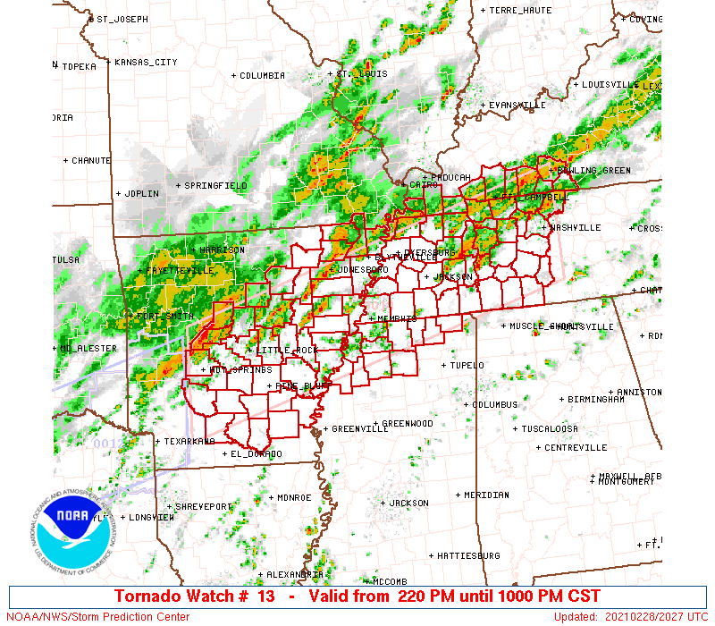
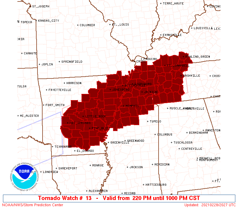
Tornado Watch Number 13
NWS Storm Prediction Center Norman OK
220 PM CST Sun Feb 28 2021
The NWS Storm Prediction Center has issued a
* Tornado Watch for portions of
Central and Eastern Arkansas
Southwest Kentucky
Missouri Bootheel
Northern Mississippi
Western and Middle Tennessee
* Effective this Sunday afternoon and evening from 220 PM until
1000 PM CST.
* Primary threats include...
A few tornadoes likely
Widespread damaging winds likely with isolated significant gusts
to 75 mph possible
Isolated very large hail events to 2 inches in diameter possible
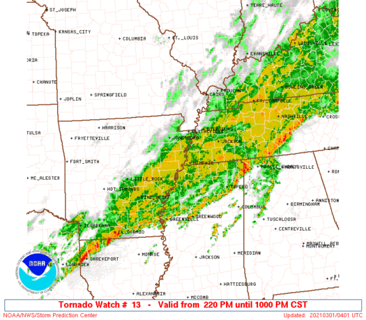
SUMMARY...Thunderstorms are forecast to develop across the watch
area through the afternoon and evening hours - with a few intense
thunderstorms expected. Damaging winds are the most likely threat,
but large hail and a few tornadoes are also possible from the most
organized storms.
The tornado watch area is approximately along and 60 statute miles
north and south of a line from 20 miles southwest of Hot Springs AR
to 15 miles east northeast of Nashville TN. For a complete depiction
of the watch see the associated watch outline update (WOUS64 KWNS
WOU3).
PRECAUTIONARY/PREPAREDNESS ACTIONS...
REMEMBER...A Tornado Watch means conditions are favorable for
tornadoes and severe thunderstorms in and close to the watch
area. Persons in these areas should be on the lookout for
threatening weather conditions and listen for later statements
and possible warnings.
&&
OTHER WATCH INFORMATION...CONTINUE...WW 12...
AVIATION...Tornadoes and a few severe thunderstorms with hail
surface and aloft to 2 inches. Extreme turbulence and surface wind
gusts to 65 knots. A few cumulonimbi with maximum tops to 450. Mean
storm motion vector 25035.
...Hart

   SEL3

   URGENT - IMMEDIATE BROADCAST REQUESTED
   Tornado Watch Number 13
   NWS Storm Prediction Center Norman OK
   220 PM CST Sun Feb 28 2021

   The NWS Storm Prediction Center has issued a

   * Tornado Watch for portions of
     Central and Eastern Arkansas
     Southwest Kentucky
     Missouri Bootheel
     Northern Mississippi
     Western and Middle Tennessee

   * Effective this Sunday afternoon and evening from 220 PM until
     1000 PM CST.

   * Primary threats include...
     A few tornadoes likely
     Widespread damaging winds likely with isolated significant gusts
       to 75 mph possible
     Isolated very large hail events to 2 inches in diameter possible

   SUMMARY...Thunderstorms are forecast to develop across the watch
   area through the afternoon and evening hours - with a few intense
   thunderstorms expected.  Damaging winds are the most likely threat,
   but large hail and a few tornadoes are also possible from the most
   organized storms.

   The tornado watch area is approximately along and 60 statute miles
   north and south of a line from 20 miles southwest of Hot Springs AR
   to 15 miles east northeast of Nashville TN. For a complete depiction
   of the watch see the associated watch outline update (WOUS64 KWNS
   WOU3).

   PRECAUTIONARY/PREPAREDNESS ACTIONS...

   REMEMBER...A Tornado Watch means conditions are favorable for
   tornadoes and severe thunderstorms in and close to the watch
   area. Persons in these areas should be on the lookout for
   threatening weather conditions and listen for later statements
   and possible warnings.

   &&

   OTHER WATCH INFORMATION...CONTINUE...WW 12...

   AVIATION...Tornadoes and a few severe thunderstorms with hail
   surface and aloft to 2 inches. Extreme turbulence and surface wind
   gusts to 65 knots. A few cumulonimbi with maximum tops to 450. Mean
   storm motion vector 25035.

   ...Hart
 Note:
The Aviation Watch (SAW) product is an approximation to the watch area.
The actual watch is depicted by the shaded areas.
Note:
The Aviation Watch (SAW) product is an approximation to the watch area.
The actual watch is depicted by the shaded areas.
   SAW3
   WW 13 TORNADO AR KY MO MS TN 282020Z - 010400Z
   AXIS..60 STATUTE MILES NORTH AND SOUTH OF LINE..
   20SW HOT/HOT SPRINGS AR/ - 15ENE BNA/NASHVILLE TN/
   ..AVIATION COORDS.. 50NM N/S /58NE TXK - 13ENE BNA/
   HAIL SURFACE AND ALOFT..2 INCHES. WIND GUSTS..65 KNOTS.
   MAX TOPS TO 450. MEAN STORM MOTION VECTOR 25035.

   LAT...LON 35139335 37088643 35348643 33409335

   THIS IS AN APPROXIMATION TO THE WATCH AREA.  FOR A
   COMPLETE DEPICTION OF THE WATCH SEE WOUS64 KWNS
   FOR WOU3.
Watch 13 Status Report Messages:
STATUS REPORT #5 ON WW 13

VALID 010345Z - 010440Z

SEVERE WEATHER THREAT CONTINUES RIGHT OF A LINE FROM 25 ENE TXK
TO 40 NW ELD TO 5 ENE PBF TO 45 E PBF TO 50 NNW GWO TO 35 WNW MSL
TO 50 WSW BNA TO 30 NE BNA.

..BROYLES..03/01/21

ATTN...WFO...LZK...MEG...LMK...PAH...OHX...

&&

STATUS REPORT FOR WT 13

SEVERE WEATHER THREAT CONTINUES FOR THE FOLLOWING AREAS

ARC011-013-041-043-079-103-010440-

AR
.    ARKANSAS COUNTIES INCLUDED ARE

BRADLEY 	     CALHOUN		 DESHA
DREW		     LINCOLN		 OUACHITA
$$


TNC055-099-101-117-119-181-187-010440-

TN
.    TENNESSEE COUNTIES INCLUDED ARE

GILES		     LAWRENCE		 LEWIS
MARSHALL	     MAURY		 WAYNE
WILLIAMSON
$$


THE WATCH STATUS MESSAGE IS FOR GUIDANCE PURPOSES ONLY.  PLEASE
REFER TO WATCH COUNTY NOTIFICATION STATEMENTS FOR OFFICIAL
INFORMATION ON COUNTIES...INDEPENDENT CITIES AND MARINE ZONES
CLEARED FROM SEVERE THUNDERSTORM AND TORNADO WATCHES.
$$

STATUS REPORT #4 ON WW 13

VALID 010225Z - 010340Z

SEVERE WEATHER THREAT CONTINUES RIGHT OF A LINE FROM 35 ENE TXK
TO 30 ESE PBF TO 45 W UOX TO 20 SE MEM TO 25 S MKL TO 50 E MKL TO
5 SW BNA TO 25 SSE BWG.

..BENTLEY..03/01/21

ATTN...WFO...LZK...MEG...LMK...PAH...OHX...

&&

STATUS REPORT FOR WT 13

SEVERE WEATHER THREAT CONTINUES FOR THE FOLLOWING AREAS

ARC011-013-041-043-079-103-010340-

AR
.    ARKANSAS COUNTIES INCLUDED ARE

BRADLEY 	     CALHOUN		 DESHA
DREW		     LINCOLN		 OUACHITA
$$


MSC003-009-027-071-093-107-119-139-010340-

MS
.    MISSISSIPPI COUNTIES INCLUDED ARE

ALCORN		     BENTON		 COAHOMA
LAFAYETTE	     MARSHALL		 PANOLA
QUITMAN 	     TIPPAH
$$


TNC037-039-055-069-071-081-099-101-109-117-119-135-165-181-187-
010340-

TN
.    TENNESSEE COUNTIES INCLUDED ARE

DAVIDSON	     DECATUR		 GILES
HARDEMAN	     HARDIN		 HICKMAN
LAWRENCE	     LEWIS		 MCNAIRY
MARSHALL	     MAURY		 PERRY
SUMNER		     WAYNE		 WILLIAMSON
$$


THE WATCH STATUS MESSAGE IS FOR GUIDANCE PURPOSES ONLY.  PLEASE
REFER TO WATCH COUNTY NOTIFICATION STATEMENTS FOR OFFICIAL
INFORMATION ON COUNTIES...INDEPENDENT CITIES AND MARINE ZONES
CLEARED FROM SEVERE THUNDERSTORM AND TORNADO WATCHES.
$$

STATUS REPORT #3 ON WW 13

VALID 010105Z - 010240Z

SEVERE WEATHER THREAT CONTINUES RIGHT OF A LINE FROM 45 NE TXK TO
30 WSW PBF TO 30 ENE PBF TO 45 WSW MEM TO 30 NE MEM TO 5 NE MKL
TO 45 ENE MKL TO 20 SSW CKV TO 10 E CKV TO 15 SW BWG TO 20 NE BWG.

FOR ADDITIONAL INFORMATION SEE MESOSCALE DISCUSSION 140

..BENTLEY..03/01/21

ATTN...WFO...LZK...MEG...LMK...PAH...OHX...

&&

STATUS REPORT FOR WT 13

SEVERE WEATHER THREAT CONTINUES FOR THE FOLLOWING AREAS

ARC001-011-013-019-025-039-041-043-079-103-107-010240-

AR
.    ARKANSAS COUNTIES INCLUDED ARE

ARKANSAS	     BRADLEY		 CALHOUN
CLARK		     CLEVELAND		 DALLAS
DESHA		     DREW		 LINCOLN
OUACHITA	     PHILLIPS
$$


KYC003-213-227-010240-

KY
.    KENTUCKY COUNTIES INCLUDED ARE

ALLEN		     SIMPSON		 WARREN
$$


MSC003-009-027-033-071-093-107-119-137-139-143-010240-

MS
.    MISSISSIPPI COUNTIES INCLUDED ARE

ALCORN		     BENTON		 COAHOMA
DESOTO		     LAFAYETTE		 MARSHALL
PANOLA		     QUITMAN		 TATE
TIPPAH		     TUNICA
$$


TNC021-023-037-039-043-047-055-069-071-077-081-083-085-099-101-
109-113-117-119-125-135-147-157-165-181-187-010240-

TN
.    TENNESSEE COUNTIES INCLUDED ARE

CHEATHAM	     CHESTER		 DAVIDSON
DECATUR 	     DICKSON		 FAYETTE
GILES		     HARDEMAN		 HARDIN
HENDERSON	     HICKMAN		 HOUSTON
HUMPHREYS	     LAWRENCE		 LEWIS
MCNAIRY 	     MADISON		 MARSHALL
MAURY		     MONTGOMERY 	 PERRY
ROBERTSON	     SHELBY		 SUMNER
WAYNE		     WILLIAMSON
$$


THE WATCH STATUS MESSAGE IS FOR GUIDANCE PURPOSES ONLY.  PLEASE
REFER TO WATCH COUNTY NOTIFICATION STATEMENTS FOR OFFICIAL
INFORMATION ON COUNTIES...INDEPENDENT CITIES AND MARINE ZONES
CLEARED FROM SEVERE THUNDERSTORM AND TORNADO WATCHES.
$$

STATUS REPORT #2 ON WW 13

VALID 010005Z - 010140Z

SEVERE WEATHER THREAT CONTINUES RIGHT OF A LINE FROM 35 SW HOT TO
25 SE HOT TO 25 ESE LIT TO 55 W MEM TO 30 NW MEM TO 20 SSW DYR TO
20 NNW MKL TO 45 NNE MKL TO 35 WSW HOP TO 25 NW HOP.

..BENTLEY..03/01/21

ATTN...WFO...LZK...MEG...LMK...PAH...OHX...

&&

STATUS REPORT FOR WT 13

SEVERE WEATHER THREAT CONTINUES FOR THE FOLLOWING AREAS

ARC001-011-013-019-025-035-039-041-043-053-069-077-079-085-095-
103-107-123-010140-

AR
.    ARKANSAS COUNTIES INCLUDED ARE

ARKANSAS	     BRADLEY		 CALHOUN
CLARK		     CLEVELAND		 CRITTENDEN
DALLAS		     DESHA		 DREW
GRANT		     JEFFERSON		 LEE
LINCOLN 	     LONOKE		 MONROE
OUACHITA	     PHILLIPS		 ST. FRANCIS
$$


KYC003-047-141-213-219-221-227-010140-

KY
.    KENTUCKY COUNTIES INCLUDED ARE

ALLEN		     CHRISTIAN		 LOGAN
SIMPSON 	     TODD		 TRIGG
WARREN
$$


MSC003-009-027-033-071-093-107-119-137-139-143-010140-

MS
.    MISSISSIPPI COUNTIES INCLUDED ARE

ALCORN		     BENTON		 COAHOMA
DESOTO		     LAFAYETTE		 MARSHALL
PANOLA		     QUITMAN		 TATE
TIPPAH		     TUNICA
$$


TNC005-017-021-023-033-037-039-043-047-055-069-071-075-077-079-
081-083-085-097-099-101-109-113-117-119-125-135-147-157-161-165-
167-181-187-010140-

TN
.    TENNESSEE COUNTIES INCLUDED ARE

BENTON		     CARROLL		 CHEATHAM
CHESTER 	     CROCKETT		 DAVIDSON
DECATUR 	     DICKSON		 FAYETTE
GILES		     HARDEMAN		 HARDIN
HAYWOOD 	     HENDERSON		 HENRY
HICKMAN 	     HOUSTON		 HUMPHREYS
LAUDERDALE	     LAWRENCE		 LEWIS
MCNAIRY 	     MADISON		 MARSHALL
MAURY		     MONTGOMERY 	 PERRY
ROBERTSON	     SHELBY		 STEWART
SUMNER		     TIPTON		 WAYNE
WILLIAMSON
$$


THE WATCH STATUS MESSAGE IS FOR GUIDANCE PURPOSES ONLY.  PLEASE
REFER TO WATCH COUNTY NOTIFICATION STATEMENTS FOR OFFICIAL
INFORMATION ON COUNTIES...INDEPENDENT CITIES AND MARINE ZONES
CLEARED FROM SEVERE THUNDERSTORM AND TORNADO WATCHES.
$$

STATUS REPORT #1 ON WW 13

VALID 282300Z - 010040Z

SEVERE WEATHER THREAT CONTINUES RIGHT OF A LINE FROM 35 SW HOT TO
10 ESE HOT TO 5 ESE LIT TO 45 SSE BVX TO 30 SSW JBR TO 10 S JBR
TO 30 E JBR TO 15 WNW DYR TO 40 NNE DYR.

FOR ADDITIONAL INFORMATION SEE MESOSCALE DISCUSSION 138

..BENTLEY..02/28/21

ATTN...WFO...LZK...MEG...LMK...PAH...OHX...

&&

STATUS REPORT FOR WT 13

SEVERE WEATHER THREAT CONTINUES FOR THE FOLLOWING AREAS

ARC001-011-013-019-025-035-037-039-041-043-053-059-069-077-079-
085-093-095-103-107-111-117-123-147-010040-

AR
.    ARKANSAS COUNTIES INCLUDED ARE

ARKANSAS	     BRADLEY		 CALHOUN
CLARK		     CLEVELAND		 CRITTENDEN
CROSS		     DALLAS		 DESHA
DREW		     GRANT		 HOT SPRING
JEFFERSON	     LEE		 LINCOLN
LONOKE		     MISSISSIPPI	 MONROE
OUACHITA	     PHILLIPS		 POINSETT
PRAIRIE 	     ST. FRANCIS	 WOODRUFF
$$


KYC003-035-047-075-083-105-141-213-219-221-227-010040-

KY
.    KENTUCKY COUNTIES INCLUDED ARE

ALLEN		     CALLOWAY		 CHRISTIAN
FULTON		     GRAVES		 HICKMAN
LOGAN		     SIMPSON		 TODD
TRIGG		     WARREN
$$


MSC003-009-027-033-071-093-107-119-137-139-143-010040-

MS
.    MISSISSIPPI COUNTIES INCLUDED ARE

ALCORN		     BENTON		 COAHOMA
DESOTO		     LAFAYETTE		 MARSHALL
PANOLA		     QUITMAN		 TATE
TIPPAH		     TUNICA
$$


TNC005-017-021-023-033-037-039-043-045-047-053-055-069-071-075-
077-079-081-083-085-097-099-101-109-113-117-119-125-131-135-147-
157-161-165-167-181-183-187-010040-

TN
.    TENNESSEE COUNTIES INCLUDED ARE

BENTON		     CARROLL		 CHEATHAM
CHESTER 	     CROCKETT		 DAVIDSON
DECATUR 	     DICKSON		 DYER
FAYETTE 	     GIBSON		 GILES
HARDEMAN	     HARDIN		 HAYWOOD
HENDERSON	     HENRY		 HICKMAN
HOUSTON 	     HUMPHREYS		 LAUDERDALE
LAWRENCE	     LEWIS		 MCNAIRY
MADISON 	     MARSHALL		 MAURY
MONTGOMERY	     OBION		 PERRY
ROBERTSON	     SHELBY		 STEWART
SUMNER		     TIPTON		 WAYNE
WEAKLEY 	     WILLIAMSON
$$


THE WATCH STATUS MESSAGE IS FOR GUIDANCE PURPOSES ONLY.  PLEASE
REFER TO WATCH COUNTY NOTIFICATION STATEMENTS FOR OFFICIAL
INFORMATION ON COUNTIES...INDEPENDENT CITIES AND MARINE ZONES
CLEARED FROM SEVERE THUNDERSTORM AND TORNADO WATCHES.
$$
Note:
Click for Complete Product Text.
Tornadoes
Probability of 2 or more tornadoes
|
Mod (60%)
|
Probability of 1 or more strong (EF2-EF5) tornadoes
|
Low (20%)
|
Wind
Probability of 10 or more severe wind events
|
High (80%)
|
Probability of 1 or more wind events > 65 knots
|
Mod (30%)
|
Hail
Probability of 10 or more severe hail events
|
Mod (30%)
|
Probability of 1 or more hailstones > 2 inches
|
Mod (30%)
|
Combined Severe Hail/Wind
Probability of 6 or more combined severe hail/wind events
|
High (>95%)
|
For each watch, probabilities for particular events inside the watch
(listed above in each table) are determined by the issuing forecaster.
The "Low" category contains probability values ranging from less than 2%
to 20% (EF2-EF5 tornadoes), less than 5% to 20% (all other probabilities),
"Moderate" from 30% to 60%, and "High" from 70% to greater than 95%.
High values are bolded and lighter in color to provide awareness of
an increased threat for a particular event.


 @NWSSPC