SPC AC 260741
Day 3 Convective Outlook
NWS Storm Prediction Center Norman OK
0241 AM CDT Sat Apr 26 2025
Valid 281200Z - 291200Z
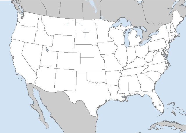
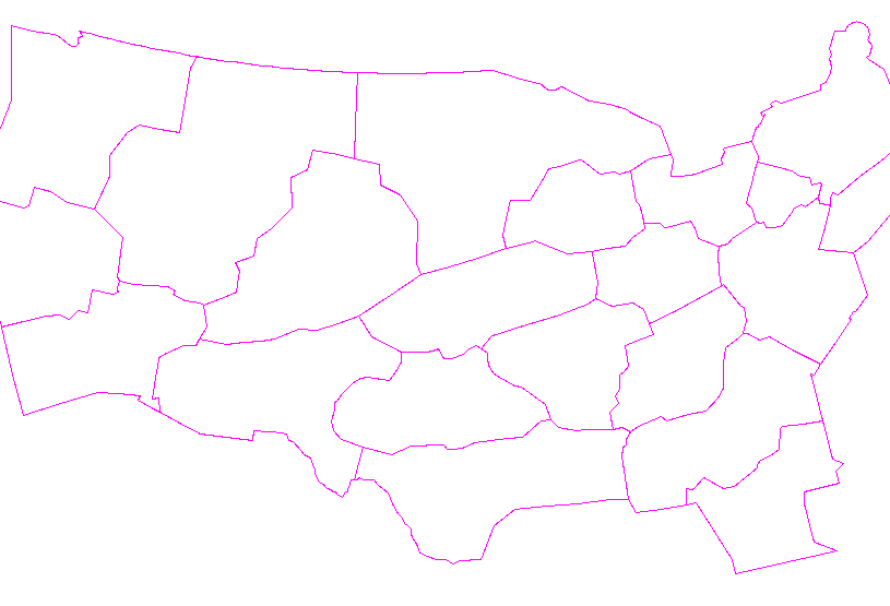
...THERE IS A MODERATE RISK OF SEVERE THUNDERSTORMS FROM CENTRAL
IOWA INTO SOUTHEAST MINNESOTA AND WESTERN WISCONSIN...
...SUMMARY...
An outbreak of severe weather is likely across portions of the
Midwest and Upper Midwest. Large hail, severe wind gusts, and strong
to intense tornadoes are likely.
...A tornado outbreak with the potential for strong to intense
tornadoes is possible on Monday...
...Midwest into the Upper Midwest...
A strong mid-level jet streak will move rapidly northeastward from
the Southwest to the Upper Midwest on Monday. As this occurs, a
surface low will deepen and move from the northern Plains to the
northern Great Lakes. Strong southwesterly lower tropospheric flow
will advect high theta-e air northward across the Midwest and into
parts of the Upper Midwest. Broken to scattered cloud cover will
support surface heating and strong destabilization across the warm
sector in Iowa and into southeast Minnesota and western Wisconsin.
Severe storms may develop as early as mid-day across western
Minnesota and western Iowa on the nose of a 70-80 knot mid-level jet
streak. These storms may begin as supercells, but mode may become
more linear as the cold front intersects the dryline across
Minnesota during the afternoon. Even if mode is more linear,
embedded tornadoes will be possible given the strengthening
low-level shear.
Farther south and east, a more discrete mode will be favored within
a weakly capped warm sector. As lower tropospheric flow strengthens
through the day, the warm sector will expand rapidly northeastward,
creating a broad warm-sector featuring moderate to strong
instability and very strong (60+ knots) shear. Increasing forcing
during the afternoon should be sufficient to overcome weak capping
across the warm sector. Therefore open warm sector supercells will
be possible in addition to supercells along the eastward advancing
dryline. Any supercells which can develop within this increasingly
favorable environment Monday afternoon/evening will be capable of
strong to intense tornadoes. By late evening, a squall line will
likely overtake much of the discrete convection as the cold front
advances rapidly southeast. Severe wind gusts and embedded tornadoes
will remain possible through the late evening and perhaps into the
overnight hours.
...Central/Southern Plains...
A strongly unstable and strongly sheared warm sector will exist
along and east of the dryline from eastern Kansas southward to West
Texas. Forcing is much weaker than farther north with only weak
height falls along the dryline. However, most guidance shows minimal
inhibition along the dryline and at least isolated storm
development, perhaps aided by some nocturnal low-level jet increase
during the evening. Any supercells which develop will pose a threat
for all severe hazards including the potential for strong tornadoes.
..Bentley.. 04/26/2025
CLICK TO GET WUUS03 PTSDY3 PRODUCT
NOTE: THE NEXT DAY 3 OUTLOOK IS SCHEDULED BY 1930Z


 @NWSSPC