SPC Convective Outlooks
Jeremy Grams and Bill Bunting, Storm Prediction Center
Days 1, 2, and 3
Overview: Convective outlooks for days 1, 2, and 3 consist of categorical and probabilistic graphics that depict severe and general thunderstorm threats across the continental United States, along with a text narrative.
Graphical categorical risk: Using numbers, words, and colors, the categorical graphic depicts general thunderstorm areas (TSTM-light green) and up to five risk types (1-MRGL-dark green, 2-SLGT-yellow, 3-ENH-orange, 4-MDT-red, and 5-HIGH-magenta) based on the coverage and intensity of organized severe weather such as supercells, squall lines, and multicell thunderstorm complexes. Pulse type thunderstorms, consisting primarily of solitary brief severe updrafts (often found in weakly sheared environments), are not considered organized.
The TSTM area encloses where a 10% or higher probability of thunderstorms is forecast during the valid period. A 1-MRGL-dark green risk area includes severe storms of either limited organization and longevity, or very low coverage and marginal intensity. A 2-SLGT-yellow risk area implies organized severe thunderstorms are expected, but usually in low coverage with varying levels of intensity. A 3-ENH-orange risk area depicts a greater concentration of organized severe thunderstorms with varying levels of intensity. A 4-MDT-red risk indicates potential for widespread severe weather with several tornadoes and/or numerous severe thunderstorms, some of which may be intense. A 5-HIGH-magenta risk area suggests a severe weather outbreak is expected from either numerous intense and long-track tornadoes, or a long-lived derecho system with hurricane-force wind gusts producing widespread damage.
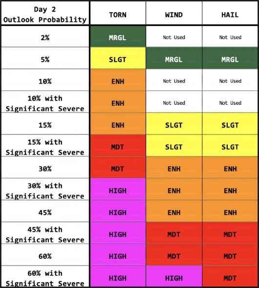
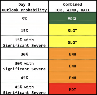
Graphical probabilistic risk: The probability of severe weather drives the outlook categories, with the tables below showing the conversion for each threshold. On days 1 and 2, the outlook contains individual severe probabilities for tornadoes, wind, and hail. With greater uncertainty about severe-storm type into the future, the outlook on day 3 only forecast the combined probability of all three types of severe weather. For all outlooks, the probability values represent the chance of severe weather occurring within 25 miles of any point, which is about the size of a major metropolitan area.
As an example, if you have a 15% probability for tornadoes, this means you have a 15% chance of a tornado occurring within 25 miles of your location. This may seem like a low number, but a tornado is very uncommon at any one location. Normally, your chances of getting hit by a tornado or other severe weather are small, purely based on statistical average. Let's say you have a 1% statistical (climatology) history of tornadoes within 25 miles on this day, which still is large. Having a 15% probability means 15 times the normal odds of a tornado nearby, meaning it should be taken seriously. The probabilities for severe thunderstorm wind and hail also have the same meaning as they do for tornadoes, but typically will be higher numbers than for tornadoes, since they are much more common.
Sometimes, a black hatched area will be overlaid with the severe probabilities. Black hatching means a 10% or higher probability for significant severe events within 25 miles of any point. "Significant" is defined as: tornadoes rated EF2 or greater, thunderstorm wind gusts of hurricane force (74 mph) or higher, or hail 2 inches or larger in diameter.
The outlook on day 3 combine all forms (tornado, wind, and hail) into a single black hatched area for a 10% or higher significant-severe risk. In addition, for tropical cyclones (hurricanes, tropical storms and depressions), the outlook on day 3 allows a 5% total severe probability to be a SLGT risk because they are specifically tornado-driven.
Day 1 Outlook Probability to Category
Conversion

Day 2 Outlook Probability to Category
Conversion
Day 3 Outlook Probability to Category
Conversion
Text narrative: The outlook text begins with a listing of severe thunderstorm risk areas by state and/or geographic region, followed by a succinct summary of the type(s) of threat along with timing that is focused on the highest-risk areas. The rest of the outlook text is written in scientific language for sophisticated users. A synopsis section is usually included and gives a general overview of the weather pattern, emphasizing features that will influence the severe and general thunderstorm threats. The narrative technical discussion is usually separated by geographic areas. Within these individual geographic areas, the text offers meteorological reasoning and justification for the type of coverage and intensity attendant to the severe weather threat.
Day 4-8
Overview: The Day 4-8 Severe Weather Outlook consists of probabilistic forecasts depicting the severe weather threat with a separate graphic for each day, along with a text narrative for the entire period. This outlook is issued once a day by 400 am CST/CDT and covers the period of 72 to 192 hours from 1200 UTC on the morning of product issuance.
Graphical probabilistic risk: Two probabilistic thresholds of 15% and 30% can be forecast. Highlighted areas are equivalent to 2-SLGT-yellow or 3-ENH-orange risks on the Day 1-3 Convective Outlooks. On rare occasions, the outlook text will begin with a headline for the possibility of a severe weather outbreak. If no 15% areas are forecast, one of the following phrases will be used:
PREDICTABILITY TOO LOW: Used to indicate severe storms may be possible based on some model scenarios. However, the location or occurrence of severe storms is in doubt due to large spread in model guidance and/or minimal run-to-run continuity.
POTENTIAL TOO LOW: Used to indicate that 15% or greater severe probabilities appear highly unlikely on that day.
|
D4 |
Day 4 |
D7 |
Day 7 |
|
D5 |
Day 5 |
D8 |
Day 8 |
|
D6 |
Day 6 |
Each
day is 12 UTC-12 UTC
|
|
Text narrative: The outlook text is written in scientific language for sophisticated users with a technical discussion that offers a general overview of the weather pattern that will influence the severe thunderstorm threat during the entire 5-day period, along with meteorological reasoning and justification. The text narrative is provided regardless of whether severe thunderstorm areas are included. On rare occasions, the outlook text will begin with a headline for the possibility of a severe weather outbreak.
Updated: February 29, 2020