|
| Mesoscale Discussion 1599 |
|
< Previous MD Next MD >
|
|
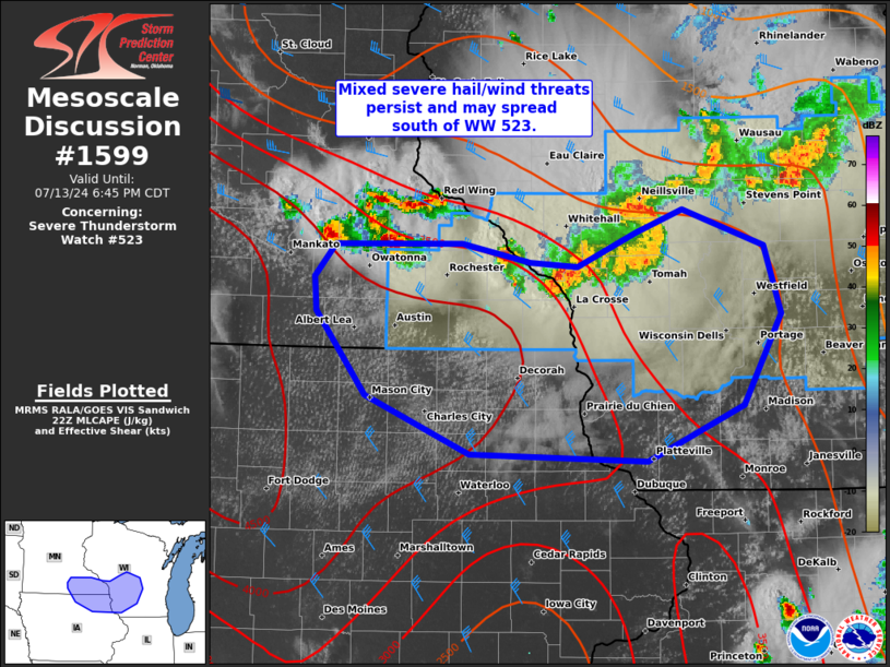
   Mesoscale Discussion 1599
   NWS Storm Prediction Center Norman OK
   0514 PM CDT Sat Jul 13 2024

   Areas affected...Southwest WI...southeast MN...northeast IA

   Concerning...Severe Thunderstorm Watch 523...

   Valid 132214Z - 132345Z

   The severe weather threat for Severe Thunderstorm Watch 523
   continues.

   SUMMARY...An arc of strong to severe thunderstorms within and just
   west of WW 523 across southwest Wisconsin and southeast Minnesota
   may spread to the south of WW 523 across parts of northeast Iowa and
   far southern Wisconsin. Monitoring for the possibility of an
   additional severe thunderstorm watch farther south.

   DISCUSSION...Primary near-term severe potential has been
   increasingly focused along the trailing outflow behind a small
   linear cluster in southwest WI that has produced strong measured
   gusts and at least one report of tree damage thus far. The discrete
   supercells along the outflow boundary have held nearly stationary
   with a slow, east-southeastward drift. A tornado or two, large hail
   to around 2 inches in diameter, and localized damaging winds will
   remain the primary near-term threats.

   With an extremely unstable airmass prevalent over southwest MN and
   northwest IA, it is plausible that a similar upscale growth
   evolution with small-scale bowing structures will occur towards the
   MS Valley in northeast IA and far southern WI. Should this occur, an
   additional severe thunderstorm watch may be needed south of WW 423.

   ..Grams.. 07/13/2024

   ...Please see www.spc.noaa.gov for graphic product...

   ATTN...WFO...GRB...MKX...ARX...MPX...DMX...

   LAT...LON   44229354 44249231 44119165 44089119 44319062 44489018
               44218938 43748922 43108960 42719052 42759223 43179325
               43769372 43999375 44229354
|
|
Top/All Mesoscale Discussions/Forecast Products/Home
|
|


 @NWSSPC