|
| Mesoscale Discussion 1598 |
|
< Previous MD Next MD >
|
|
Mesoscale Discussion 1598
NWS Storm Prediction Center Norman OK
0357 PM CDT Sat Jul 13 2024
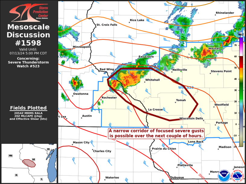
Areas affected...portions of central Wisconsin
Concerning...Severe Thunderstorm Watch 523...
Valid 132057Z - 132200Z
The severe weather threat for Severe Thunderstorm Watch 523
continues.
SUMMARY...A narrow corridor of focused damaging winds (perhaps
severe) may accompany a small bowing segment over the next couple of
hours. Longevity of this bowing complex however is uncertain.
DISCUSSION...MRMS mosaic radar imagery depicts a small bowing
complex that has recently materialized over portions of far western
WI in the past hour. KARX regional radar shows a rear-inflow jet
present, with inbound velocities approaching 80 kts about 1 km AGL.
Assuming efficient downward momentum transport, the ongoing complex
may be producing damaging, perhaps severe gusts in abundance. The
complex is currently traversing a buoyancy gradient, with MLCAPE
exceeding 2000 J/kg amid 30+ kts of effective bulk shear. However,
the ARX VAD profile suggests that vertical wind shear (including
low-level shear) is not particularly strong, so questions remain
regarding how long the bow echo complex will last. Nonetheless,
there is some potential for a continued narrow swath of focused
damaging winds (perhaps severe, with gusts peaking in the 65-80 mph
range) over the next couple of hours.
..Squitieri.. 07/13/2024
...Please see www.spc.noaa.gov for graphic product...
ATTN...WFO...GRB...ARX...MPX...
LAT...LON 44629194 44639114 44299028 43948991 43679016 43629065
43799132 44009181 44309226 44409229 44629194
|
|
Top/All Mesoscale Discussions/Forecast Products/Home
|
|


 @NWSSPC