|
| Mesoscale Discussion 1600 |
|
< Previous MD Next MD >
|
|
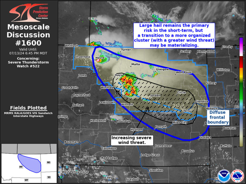
   Mesoscale Discussion 1600
   NWS Storm Prediction Center Norman OK
   0541 PM CDT Sat Jul 13 2024

   Areas affected...Northern to eastern Montana

   Concerning...Severe Thunderstorm Watch 522...

   Valid 132241Z - 140045Z

   The severe weather threat for Severe Thunderstorm Watch 522
   continues.

   SUMMARY...Large hail remains the primary severe threat for the
   short-term across north-central Montana, but a transition into a
   more organized cluster/linear segment may occur within the next 1-2
   hours. This would support an increasing wind threat downstream
   across eastern Montana.

   DISCUSSION...Over the past hour, a leading supercell across
   north-central MT continues to show strong deviant motion to the
   south/southeast and has a history of producing severe hail (1.0 to
   1.75 inch) per recent storm reports. For the next 30-60 minutes,
   this cell should continue to pose a risk for large to very large
   hail given a very favorable supercell environment. Radar and
   satellite trends over the past 30 minutes show increasing cumulus
   congestus and new cell development in the vicinity of the supercell
   - likely a result of strengthening ascent in close proximity to the
   supercell and its robust pressure perturbation responsible for the
   strong deviant motion. As new cells develop, cold pools will
   amalgamate leading to gradual upscale growth, likely within the next
   1-2 hours. Evolution into an organized line appears probable given
   strong (nearly 50 knots) deep-layer wind shear nearly parallel to
   the diffuse frontal boundary. Consequently, the threat for severe
   wind should increase in the coming hours downstream. Based on the
   current position of the frontal boundary, the severe threat should
   mostly remain in WW 522, but additional watch issuance may be needed
   across southeast MT in the coming hours if it becomes apparent
   convection will maintain a more southeasterly track.

   ..Moore.. 07/13/2024

   ...Please see www.spc.noaa.gov for graphic product...

   ATTN...WFO...BIS...BYZ...GGW...TFX...

   LAT...LON   47270869 47990950 48350973 48670981 48950966 48990944
               48750863 48570771 48080476 47610416 47180401 46310404
               46130419 46000443 45910468 45870500 45880530 46010583
               46270675 46600754 47270869
|
|
Top/All Mesoscale Discussions/Forecast Products/Home
|
|


 @NWSSPC