 Note:
The expiration time in the watch graphic is amended if the watch is
replaced, cancelled or extended.
Note:
Note:
The expiration time in the watch graphic is amended if the watch is
replaced, cancelled or extended.
Note: Click for
Watch Status Reports.
   SEL4

   URGENT - IMMEDIATE BROADCAST REQUESTED
   Tornado Watch Number 144
   NWS Storm Prediction Center Norman OK
   625 AM CDT Sat Apr 27 2024

   The NWS Storm Prediction Center has issued a

   * Tornado Watch for portions of
     Western Oklahoma
     Northwest Texas

   * Effective this Saturday morning and afternoon from 625 AM until
     100 PM CDT.

   * Primary threats include...
     A few tornadoes likely
     Scattered large hail and isolated very large hail events to 2.5
       inches in diameter likely
     Scattered damaging wind gusts to 70 mph possible

   SUMMARY...Thunderstorm development is underway across northwest
   Texas, and these storms will spread northeastward across western
   Oklahoma through the morning.  Despite the time of day, the
   environment will favor supercell clusters capable of producing a few
   tornadoes, very large hail up to 2.5 inches in diameter, and
   isolated damaging gusts of 60-70 mph.

   The tornado watch area is approximately along and 50 statute miles
   east and west of a line from 40 miles south of Childress TX to 20
   miles northeast of Alva OK. For a complete depiction of the watch
   see the associated watch outline update (WOUS64 KWNS WOU4).

   PRECAUTIONARY/PREPAREDNESS ACTIONS...

   REMEMBER...A Tornado Watch means conditions are favorable for
   tornadoes and severe thunderstorms in and close to the watch
   area. Persons in these areas should be on the lookout for
   threatening weather conditions and listen for later statements
   and possible warnings.

   &&

   AVIATION...Tornadoes and a few severe thunderstorms with hail
   surface and aloft to 2.5 inches. Extreme turbulence and surface wind
   gusts to 60 knots. A few cumulonimbi with maximum tops to 500. Mean
   storm motion vector 22035.

   ...Thompson
 Note:
The Aviation Watch (SAW) product is an approximation to the watch area.
The actual watch is depicted by the shaded areas.
Note:
The Aviation Watch (SAW) product is an approximation to the watch area.
The actual watch is depicted by the shaded areas.
   SAW4
   WW 144 TORNADO OK TX 271125Z - 271800Z
   AXIS..50 STATUTE MILES EAST AND WEST OF LINE..
   40S CDS/CHILDRESS TX/ - 20NE AVK/ALVA OK/
   ..AVIATION COORDS.. 45NM E/W /31S CDS - 44NNW END/
   HAIL SURFACE AND ALOFT..2.5 INCHES. WIND GUSTS..60 KNOTS.
   MAX TOPS TO 500. MEAN STORM MOTION VECTOR 22035.

   LAT...LON 33840115 36979932 36979751 33849941

   THIS IS AN APPROXIMATION TO THE WATCH AREA.  FOR A
   COMPLETE DEPICTION OF THE WATCH SEE WOUS64 KWNS
   FOR WOU4.
Watch 144 Status Report Messages:
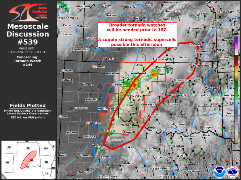
STATUS REPORT #4 ON WW 144

VALID 271635Z - 271740Z

THE SEVERE WEATHER THREAT CONTINUES ACROSS THE ENTIRE WATCH AREA.

FOR ADDITIONAL INFORMATION SEE MESOSCALE DISCUSSION 539.

..GRAMS..04/27/24

ATTN...WFO...OUN...LUB...AMA...

&&

STATUS REPORT FOR WT 144

SEVERE WEATHER THREAT CONTINUES FOR THE FOLLOWING AREAS

OKC003-009-011-039-043-045-047-053-055-057-059-065-075-093-129-
141-149-151-153-271740-

OK
.    OKLAHOMA COUNTIES INCLUDED ARE

ALFALFA 	     BECKHAM		 BLAINE
CUSTER		     DEWEY		 ELLIS
GARFIELD	     GRANT		 GREER
HARMON		     HARPER		 JACKSON
KIOWA		     MAJOR		 ROGER MILLS
TILLMAN 	     WASHITA		 WOODS
WOODWARD
$$


TXC075-087-101-155-191-197-345-483-487-271740-

TX
.    TEXAS COUNTIES INCLUDED ARE

CHILDRESS	     COLLINGSWORTH	 COTTLE
FOARD		     HALL		 HARDEMAN
MOTLEY		     WHEELER		 WILBARGER
$$


THE WATCH STATUS MESSAGE IS FOR GUIDANCE PURPOSES ONLY.  PLEASE
REFER TO WATCH COUNTY NOTIFICATION STATEMENTS FOR OFFICIAL
INFORMATION ON COUNTIES...INDEPENDENT CITIES AND MARINE ZONES
CLEARED FROM SEVERE THUNDERSTORM AND TORNADO WATCHES.
$$

STATUS REPORT #3 ON WW 144

VALID 271525Z - 271640Z

THE SEVERE WEATHER THREAT CONTINUES ACROSS THE ENTIRE WATCH AREA.

FOR ADDITIONAL INFORMATION SEE MESOSCALE DISCUSSION 538.

..GRAMS..04/27/24

ATTN...WFO...OUN...LUB...AMA...

&&

STATUS REPORT FOR WT 144

SEVERE WEATHER THREAT CONTINUES FOR THE FOLLOWING AREAS

OKC003-009-011-039-043-045-047-053-055-057-059-065-075-093-129-
141-149-151-153-271640-

OK
.    OKLAHOMA COUNTIES INCLUDED ARE

ALFALFA 	     BECKHAM		 BLAINE
CUSTER		     DEWEY		 ELLIS
GARFIELD	     GRANT		 GREER
HARMON		     HARPER		 JACKSON
KIOWA		     MAJOR		 ROGER MILLS
TILLMAN 	     WASHITA		 WOODS
WOODWARD
$$


TXC075-087-101-155-191-197-345-483-487-271640-

TX
.    TEXAS COUNTIES INCLUDED ARE

CHILDRESS	     COLLINGSWORTH	 COTTLE
FOARD		     HALL		 HARDEMAN
MOTLEY		     WHEELER		 WILBARGER
$$


THE WATCH STATUS MESSAGE IS FOR GUIDANCE PURPOSES ONLY.  PLEASE
REFER TO WATCH COUNTY NOTIFICATION STATEMENTS FOR OFFICIAL
INFORMATION ON COUNTIES...INDEPENDENT CITIES AND MARINE ZONES
CLEARED FROM SEVERE THUNDERSTORM AND TORNADO WATCHES.
$$

STATUS REPORT #2 ON WW 144

VALID 271430Z - 271540Z

THE SEVERE WEATHER THREAT CONTINUES ACROSS THE ENTIRE WATCH AREA.

FOR ADDITIONAL INFORMATION SEE MESOSCALE DISCUSSION 538

..GRAMS..04/27/24

ATTN...WFO...OUN...LUB...AMA...

&&

STATUS REPORT FOR WT 144

SEVERE WEATHER THREAT CONTINUES FOR THE FOLLOWING AREAS

OKC003-009-011-039-043-045-047-053-055-057-059-065-075-093-129-
141-149-151-153-271540-

OK
.    OKLAHOMA COUNTIES INCLUDED ARE

ALFALFA 	     BECKHAM		 BLAINE
CUSTER		     DEWEY		 ELLIS
GARFIELD	     GRANT		 GREER
HARMON		     HARPER		 JACKSON
KIOWA		     MAJOR		 ROGER MILLS
TILLMAN 	     WASHITA		 WOODS
WOODWARD
$$


TXC075-087-101-155-191-197-345-483-487-271540-

TX
.    TEXAS COUNTIES INCLUDED ARE

CHILDRESS	     COLLINGSWORTH	 COTTLE
FOARD		     HALL		 HARDEMAN
MOTLEY		     WHEELER		 WILBARGER
$$


THE WATCH STATUS MESSAGE IS FOR GUIDANCE PURPOSES ONLY.  PLEASE
REFER TO WATCH COUNTY NOTIFICATION STATEMENTS FOR OFFICIAL
INFORMATION ON COUNTIES...INDEPENDENT CITIES AND MARINE ZONES
CLEARED FROM SEVERE THUNDERSTORM AND TORNADO WATCHES.
$$

STATUS REPORT #1 ON WW 144

VALID 271330Z - 271440Z

THE SEVERE WEATHER THREAT CONTINUES ACROSS THE ENTIRE WATCH AREA.

..GRAMS..04/27/24

ATTN...WFO...OUN...LUB...AMA...

&&

STATUS REPORT FOR WT 144

SEVERE WEATHER THREAT CONTINUES FOR THE FOLLOWING AREAS

OKC003-009-011-039-043-045-047-053-055-057-059-065-075-093-129-
141-149-151-153-271440-

OK
.    OKLAHOMA COUNTIES INCLUDED ARE

ALFALFA 	     BECKHAM		 BLAINE
CUSTER		     DEWEY		 ELLIS
GARFIELD	     GRANT		 GREER
HARMON		     HARPER		 JACKSON
KIOWA		     MAJOR		 ROGER MILLS
TILLMAN 	     WASHITA		 WOODS
WOODWARD
$$


TXC075-087-101-155-191-197-345-483-487-271440-

TX
.    TEXAS COUNTIES INCLUDED ARE

CHILDRESS	     COLLINGSWORTH	 COTTLE
FOARD		     HALL		 HARDEMAN
MOTLEY		     WHEELER		 WILBARGER
$$


THE WATCH STATUS MESSAGE IS FOR GUIDANCE PURPOSES ONLY.  PLEASE
REFER TO WATCH COUNTY NOTIFICATION STATEMENTS FOR OFFICIAL
INFORMATION ON COUNTIES...INDEPENDENT CITIES AND MARINE ZONES
CLEARED FROM SEVERE THUNDERSTORM AND TORNADO WATCHES.
$$
Note:
Click for Complete Product Text.
Tornadoes
Probability of 2 or more tornadoes
|
Mod (60%)
|
Probability of 1 or more strong (EF2-EF5) tornadoes
|
Low (20%)
|
Wind
Probability of 10 or more severe wind events
|
Mod (40%)
|
Probability of 1 or more wind events > 65 knots
|
Low (20%)
|
Hail
Probability of 10 or more severe hail events
|
High (70%)
|
Probability of 1 or more hailstones > 2 inches
|
Mod (60%)
|
Combined Severe Hail/Wind
Probability of 6 or more combined severe hail/wind events
|
High (90%)
|
For each watch, probabilities for particular events inside the watch
(listed above in each table) are determined by the issuing forecaster.
The "Low" category contains probability values ranging from less than 2%
to 20% (EF2-EF5 tornadoes), less than 5% to 20% (all other probabilities),
"Moderate" from 30% to 60%, and "High" from 70% to greater than 95%.
High values are bolded and lighter in color to provide awareness of
an increased threat for a particular event.


 @NWSSPC