|
| Mesoscale Discussion 539 |
|
< Previous MD Next MD >
|
|
Mesoscale Discussion 0539
NWS Storm Prediction Center Norman OK
1057 AM CDT Sat Apr 27 2024
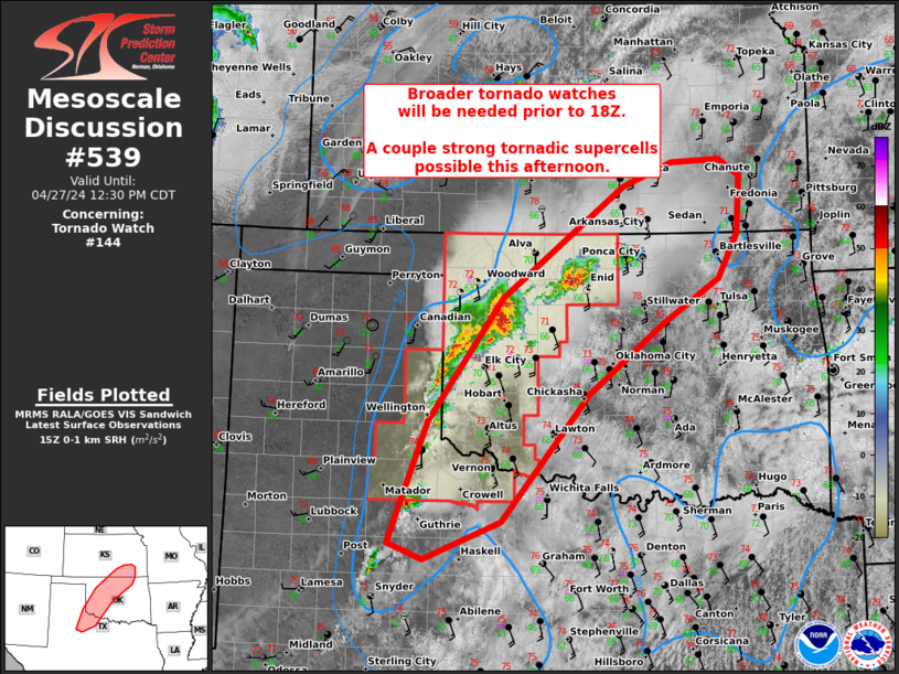
Areas affected...Northwest TX...western/northern OK...and southeast
KS
Concerning...Tornado Watch 144...
Valid 271557Z - 271730Z
The severe weather threat for Tornado Watch 144 continues.
SUMMARY...Severe threat will further increase into the afternoon
from parts of northwest Texas into southeast Kansas, including
potential for a couple strong tornadic supercells. A broader tornado
and/or multiple PDS/non-PDS tornado watches will be needed prior to
the 18Z expiration of WW 144.
DISCUSSION...Surface analysis placed the nearly stationary dryline
across the eastern TX Panhandle through northwest TX. The deepest
convection is ahead of the dryline in west-central to north-central
OK, which includes a supercell in cluster and a downstream discrete
supercell. Surface warming has been more pronounced in parts of
central OK, generally along and east of the I-35 corridor. The
leading discrete supercell should have relatively uninterrupted
inflow as it impinges on this relatively max in boundary-layer
warming. Amid a 45-kt southerly low-level jet per the TLX VWP data,
potential will exist for cyclic tornadoes that may be strong. Strong
mid-level rotation has also been noted with the supercell in cluster
now centered in Dewey County, OK, and this storm should pose a
continued threat for all hazards.
Additional storms should regenerate along the dryline farther south
into northwest TX through the afternoon given minimal MLCIN. With
weaker forcing for ascent relative to farther north, there is some
uncertainty in how quickly this activity will become severe. But the
overall environment will favor discrete supercell development,
especially as the boundary layer further warms.
..Grams.. 04/27/2024
...Please see www.spc.noaa.gov for graphic product...
ATTN...WFO...TSA...ICT...OUN...SJT...LUB...AMA...
LAT...LON 33330075 34760019 36239913 37569737 37849665 37869596
37679565 36989571 36459599 35939681 35109788 33589913
33140025 33330075
|
|
Top/All Mesoscale Discussions/Forecast Products/Home
|
|


 @NWSSPC