 Note:
The expiration time in the watch graphic is amended if the watch is
replaced, cancelled or extended.
Note:
Note:
The expiration time in the watch graphic is amended if the watch is
replaced, cancelled or extended.
Note: Click for
Watch Status Reports.
SEL3
URGENT - IMMEDIATE BROADCAST REQUESTED
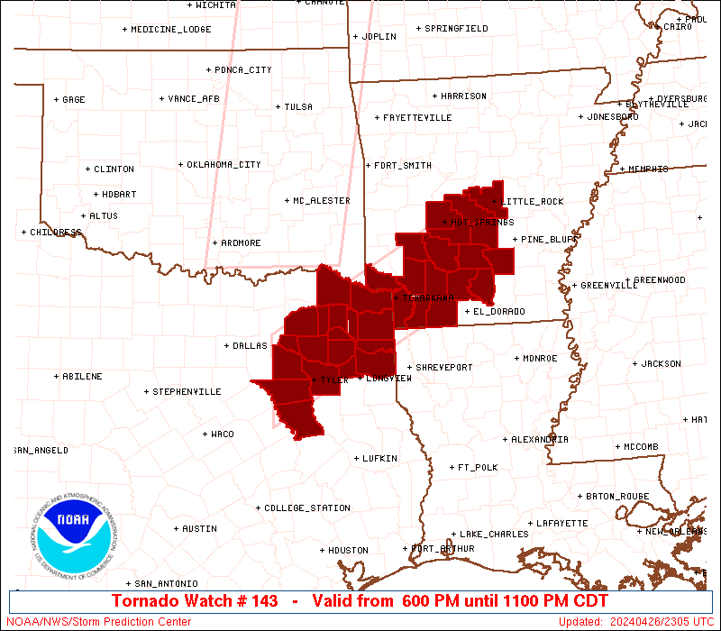
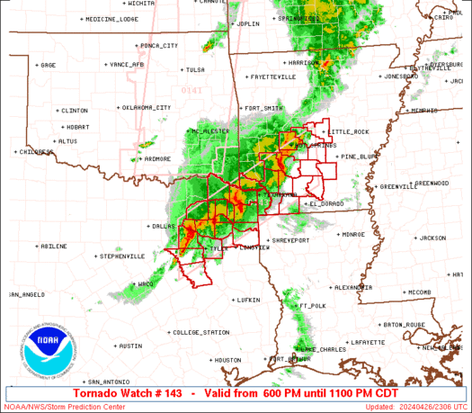
Tornado Watch Number 143
NWS Storm Prediction Center Norman OK
555 PM CDT Fri Apr 26 2024
The NWS Storm Prediction Center has issued a
* Tornado Watch for portions of
Southern and central Arkansas
Northeast Texas
* Effective this Friday afternoon and evening from 555 PM until
1100 PM CDT.
* Primary threats include...
A couple tornadoes possible
Scattered large hail and isolated very large hail events to 2
inches in diameter possible
Isolated damaging wind gusts to 70 mph possible
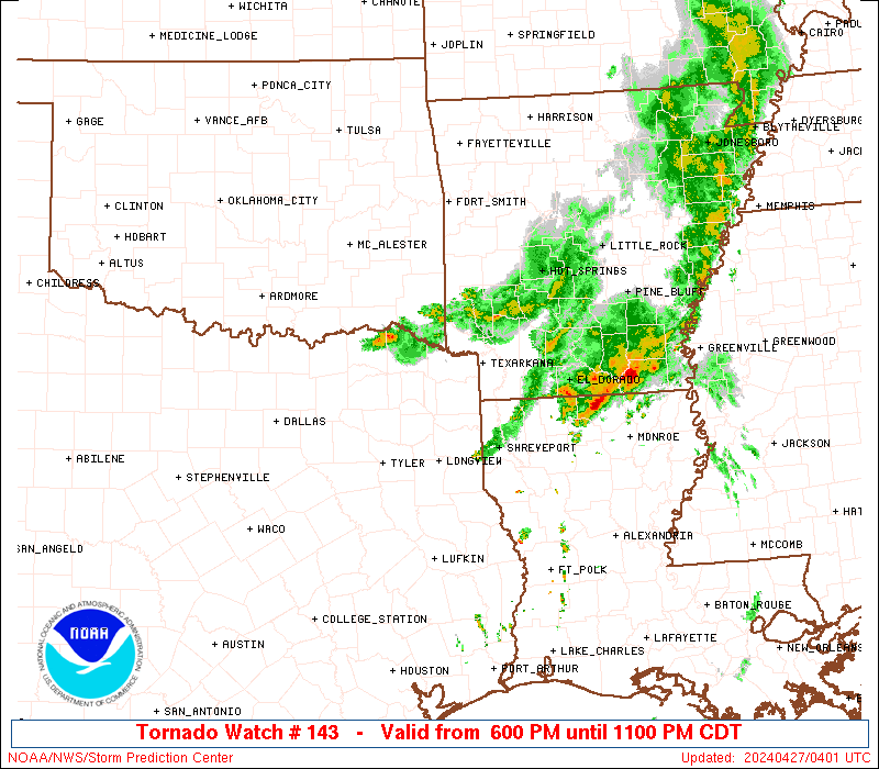
SUMMARY...A persistent band of strong-severe thunderstorms may
maintain a threat for damaging gusts, large hail and a tornado or
two into the evening over the watch area.
The tornado watch area is approximately along and 45 statute miles
north and south of a line from 40 miles west of Tyler TX to 40 miles
east southeast of Hot Springs AR. For a complete depiction of the
watch see the associated watch outline update (WOUS64 KWNS WOU3).
PRECAUTIONARY/PREPAREDNESS ACTIONS...
REMEMBER...A Tornado Watch means conditions are favorable for
tornadoes and severe thunderstorms in and close to the watch
area. Persons in these areas should be on the lookout for
threatening weather conditions and listen for later statements
and possible warnings.
&&
OTHER WATCH INFORMATION...CONTINUE...WW 139...WW 140...WW
141...WW 142...
AVIATION...Tornadoes and a few severe thunderstorms with hail
surface and aloft to 2 inches. Extreme turbulence and surface wind
gusts to 60 knots. A few cumulonimbi with maximum tops to 550. Mean
storm motion vector 24025.
...Edwards

   SEL3

   URGENT - IMMEDIATE BROADCAST REQUESTED
   Tornado Watch Number 143
   NWS Storm Prediction Center Norman OK
   555 PM CDT Fri Apr 26 2024

   The NWS Storm Prediction Center has issued a

   * Tornado Watch for portions of
     Southern and central Arkansas
     Northeast Texas

   * Effective this Friday afternoon and evening from 555 PM until
     1100 PM CDT.

   * Primary threats include...
     A couple tornadoes possible
     Scattered large hail and isolated very large hail events to 2
       inches in diameter possible
     Isolated damaging wind gusts to 70 mph possible

   SUMMARY...A persistent band of strong-severe thunderstorms may
   maintain a threat for damaging gusts, large hail and a tornado or
   two into the evening over the watch area.

   The tornado watch area is approximately along and 45 statute miles
   north and south of a line from 40 miles west of Tyler TX to 40 miles
   east southeast of Hot Springs AR. For a complete depiction of the
   watch see the associated watch outline update (WOUS64 KWNS WOU3).

   PRECAUTIONARY/PREPAREDNESS ACTIONS...

   REMEMBER...A Tornado Watch means conditions are favorable for
   tornadoes and severe thunderstorms in and close to the watch
   area. Persons in these areas should be on the lookout for
   threatening weather conditions and listen for later statements
   and possible warnings.

   &&

   OTHER WATCH INFORMATION...CONTINUE...WW 139...WW 140...WW
   141...WW 142...

   AVIATION...Tornadoes and a few severe thunderstorms with hail
   surface and aloft to 2 inches. Extreme turbulence and surface wind
   gusts to 60 knots. A few cumulonimbi with maximum tops to 550. Mean
   storm motion vector 24025.

   ...Edwards
 Note:
The Aviation Watch (SAW) product is an approximation to the watch area.
The actual watch is depicted by the shaded areas.
Note:
The Aviation Watch (SAW) product is an approximation to the watch area.
The actual watch is depicted by the shaded areas.
   SAW3
   WW 143 TORNADO AR TX 262300Z - 270400Z
   AXIS..45 STATUTE MILES NORTH AND SOUTH OF LINE..
   40W TYR/TYLER TX/ - 40ESE HOT/HOT SPRINGS AR/
   ..AVIATION COORDS.. 40NM N/S /58ESE TTT - 29SSW LIT/
   HAIL SURFACE AND ALOFT..2 INCHES. WIND GUSTS..60 KNOTS.
   MAX TOPS TO 550. MEAN STORM MOTION VECTOR 24025.

   REPLACES WW 139..OK TX

   LAT...LON 33009609 34909245 33599245 31709609

   THIS IS AN APPROXIMATION TO THE WATCH AREA.  FOR A
   COMPLETE DEPICTION OF THE WATCH SEE WOUS64 KWNS
   FOR WOU3.
Watch 143 Status Report Messages:
STATUS REPORT #4 ON WW 143
VALID 270250Z - 270340Z
SEVERE WEATHER THREAT CONTINUES RIGHT OF A LINE FROM 20 SW GGG TO
40 S PRX TO 40 W TXK TO 25 S DEQ TO 30 ENE ELD.
..THORNTON..04/27/24
ATTN...WFO...LZK...SHV...FWD...
&&
STATUS REPORT FOR WT 143
SEVERE WEATHER THREAT CONTINUES FOR THE FOLLOWING AREAS
ARC027-073-091-270340-
AR
. ARKANSAS COUNTIES INCLUDED ARE
COLUMBIA LAFAYETTE MILLER
$$
TXC037-063-067-159-183-203-315-343-449-459-270340-
TX
. TEXAS COUNTIES INCLUDED ARE
BOWIE CAMP CASS
FRANKLIN GREGG HARRISON
MARION MORRIS TITUS
UPSHUR
$$
THE WATCH STATUS MESSAGE IS FOR GUIDANCE PURPOSES ONLY. PLEASE
REFER TO WATCH COUNTY NOTIFICATION STATEMENTS FOR OFFICIAL
INFORMATION ON COUNTIES...INDEPENDENT CITIES AND MARINE ZONES
CLEARED FROM SEVERE THUNDERSTORM AND TORNADO WATCHES.
$$
STATUS REPORT #3 ON WW 143
VALID 270125Z - 270240Z
SEVERE WEATHER THREAT CONTINUES RIGHT OF A LINE FROM 20 SW GGG TO
40 S PRX TO 20 N TXK TO 40 NW ELD TO 5 N LIT TO 10 S BVX.
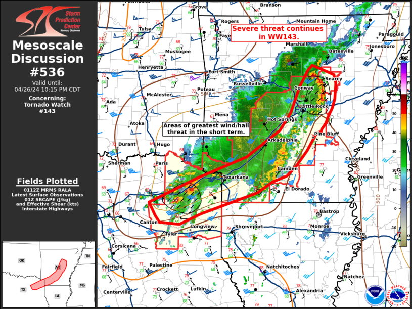
FOR ADDITIONAL INFORMATION SEE MESOSCALE DISCUSSION 536
..THORNTON..04/27/24
ATTN...WFO...LZK...SHV...FWD...
&&
STATUS REPORT FOR WT 143
SEVERE WEATHER THREAT CONTINUES FOR THE FOLLOWING AREAS
ARC013-019-025-027-039-053-069-073-085-091-103-145-270240-
AR
. ARKANSAS COUNTIES INCLUDED ARE
CALHOUN CLARK CLEVELAND
COLUMBIA DALLAS GRANT
JEFFERSON LAFAYETTE LONOKE
MILLER OUACHITA WHITE
$$
TXC037-063-067-159-183-203-315-343-449-459-270240-
TX
. TEXAS COUNTIES INCLUDED ARE
BOWIE CAMP CASS
FRANKLIN GREGG HARRISON
MARION MORRIS TITUS
UPSHUR
$$
THE WATCH STATUS MESSAGE IS FOR GUIDANCE PURPOSES ONLY. PLEASE
REFER TO WATCH COUNTY NOTIFICATION STATEMENTS FOR OFFICIAL
INFORMATION ON COUNTIES...INDEPENDENT CITIES AND MARINE ZONES
CLEARED FROM SEVERE THUNDERSTORM AND TORNADO WATCHES.
$$
STATUS REPORT #2 ON WW 143
VALID 270040Z - 270140Z
THE SEVERE WEATHER THREAT CONTINUES ACROSS THE ENTIRE WATCH AREA.
..WENDT..04/27/24
ATTN...WFO...LZK...SHV...FWD...
&&
STATUS REPORT FOR WT 143
SEVERE WEATHER THREAT CONTINUES FOR THE FOLLOWING AREAS
ARC013-019-025-027-039-045-051-053-057-059-069-073-081-085-091-
099-103-105-109-119-125-145-270140-
AR
. ARKANSAS COUNTIES INCLUDED ARE
CALHOUN CLARK CLEVELAND
COLUMBIA DALLAS FAULKNER
GARLAND GRANT HEMPSTEAD
HOT SPRING JEFFERSON LAFAYETTE
LITTLE RIVER LONOKE MILLER
NEVADA OUACHITA PERRY
PIKE PULASKI SALINE
WHITE
$$
TXC001-037-063-067-159-183-203-213-223-315-343-379-387-423-449-
459-467-499-270140-
TX
. TEXAS COUNTIES INCLUDED ARE
ANDERSON BOWIE CAMP
CASS FRANKLIN GREGG
HARRISON HENDERSON HOPKINS
MARION MORRIS RAINS
RED RIVER SMITH TITUS
UPSHUR VAN ZANDT WOOD
$$
THE WATCH STATUS MESSAGE IS FOR GUIDANCE PURPOSES ONLY. PLEASE
REFER TO WATCH COUNTY NOTIFICATION STATEMENTS FOR OFFICIAL
INFORMATION ON COUNTIES...INDEPENDENT CITIES AND MARINE ZONES
CLEARED FROM SEVERE THUNDERSTORM AND TORNADO WATCHES.
$$
STATUS REPORT #1 ON WW 143
VALID 262335Z - 270040Z
THE SEVERE WEATHER THREAT CONTINUES ACROSS THE ENTIRE WATCH AREA.
..WENDT..04/26/24
ATTN...WFO...LZK...SHV...FWD...
&&
STATUS REPORT FOR WT 143
SEVERE WEATHER THREAT CONTINUES FOR THE FOLLOWING AREAS
ARC013-019-025-027-039-051-053-057-059-073-081-091-099-103-109-
119-125-270040-
AR
. ARKANSAS COUNTIES INCLUDED ARE
CALHOUN CLARK CLEVELAND
COLUMBIA DALLAS GARLAND
GRANT HEMPSTEAD HOT SPRING
LAFAYETTE LITTLE RIVER MILLER
NEVADA OUACHITA PIKE
PULASKI SALINE
$$
TXC001-037-063-067-159-183-203-213-223-315-343-379-387-423-449-
459-467-499-270040-
TX
. TEXAS COUNTIES INCLUDED ARE
ANDERSON BOWIE CAMP
CASS FRANKLIN GREGG
HARRISON HENDERSON HOPKINS
MARION MORRIS RAINS
RED RIVER SMITH TITUS
UPSHUR VAN ZANDT WOOD
$$
THE WATCH STATUS MESSAGE IS FOR GUIDANCE PURPOSES ONLY. PLEASE
REFER TO WATCH COUNTY NOTIFICATION STATEMENTS FOR OFFICIAL
INFORMATION ON COUNTIES...INDEPENDENT CITIES AND MARINE ZONES
CLEARED FROM SEVERE THUNDERSTORM AND TORNADO WATCHES.
$$
Note:
Click for Complete Product Text.
Tornadoes
Probability of 2 or more tornadoes
|
Mod (40%)
|
Probability of 1 or more strong (EF2-EF5) tornadoes
|
Low (20%)
|
Wind
Probability of 10 or more severe wind events
|
Mod (30%)
|
Probability of 1 or more wind events > 65 knots
|
Low (20%)
|
Hail
Probability of 10 or more severe hail events
|
Mod (40%)
|
Probability of 1 or more hailstones > 2 inches
|
Mod (30%)
|
Combined Severe Hail/Wind
Probability of 6 or more combined severe hail/wind events
|
High (70%)
|
For each watch, probabilities for particular events inside the watch
(listed above in each table) are determined by the issuing forecaster.
The "Low" category contains probability values ranging from less than 2%
to 20% (EF2-EF5 tornadoes), less than 5% to 20% (all other probabilities),
"Moderate" from 30% to 60%, and "High" from 70% to greater than 95%.
High values are bolded and lighter in color to provide awareness of
an increased threat for a particular event.


 @NWSSPC