|
| Mesoscale Discussion 536 |
|
< Previous MD Next MD >
|
|
Mesoscale Discussion 0536
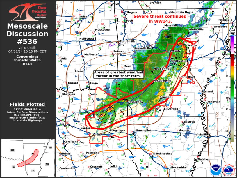
NWS Storm Prediction Center Norman OK
0814 PM CDT Fri Apr 26 2024
Areas affected...Arklatex into Southeastern/Central Missouri
Concerning...Tornado Watch 143...
Valid 270114Z - 270315Z
The severe weather threat for Tornado Watch 143 continues.
SUMMARY...Severe threat continues in WW143.
DISCUSSION...A broken line of storms continues from Arklatex into
central Missouri as with a history of reports of damaging wind up to
50-65 mph. Intensity has come down within much of this line after
loss of daytime heating. Surface objective analysis would suggest
that MLCIN is increasing, though it is noted in surface observations
that temperatures remain in the mid 70s northeast of Little Rock.
Lightning activity within this portion of line also remains very
productive. This portions of the line will maintain a damaging wind
threat in the short term.
On the tail end of the line, surface objective analysis indicates
that minimal surface-based buoyancy may be available. Storms across
this region in northeastern Texas from Mount Pleasant, TX to
Texarkana have maintained intensity but should generally weaken as
heights rise and the airmass continues to become less favorable.
Potential for damaging wind and hail will continue in the short term
in this region.
..Thornton/Edwards.. 04/27/2024
...Please see www.spc.noaa.gov for graphic product...
ATTN...WFO...LZK...SHV...FWD...
LAT...LON 33199324 32809449 32599497 32629541 32759551 32999564
32999564 33469457 33869349 34359274 34689249 35179228
35479209 35579199 35509182 35399151 35239147 34949150
34779155 34609165 34489171 34369181 34329182 34309191
33979214 33689240 33509260 33399292 33199324
|
|
Top/All Mesoscale Discussions/Forecast Products/Home
|
|


 @NWSSPC