 Note:
The expiration time in the watch graphic is amended if the watch is
replaced, cancelled or extended.
Note:
Note:
The expiration time in the watch graphic is amended if the watch is
replaced, cancelled or extended.
Note: Click for
Watch Status Reports.
SEL4
URGENT - IMMEDIATE BROADCAST REQUESTED
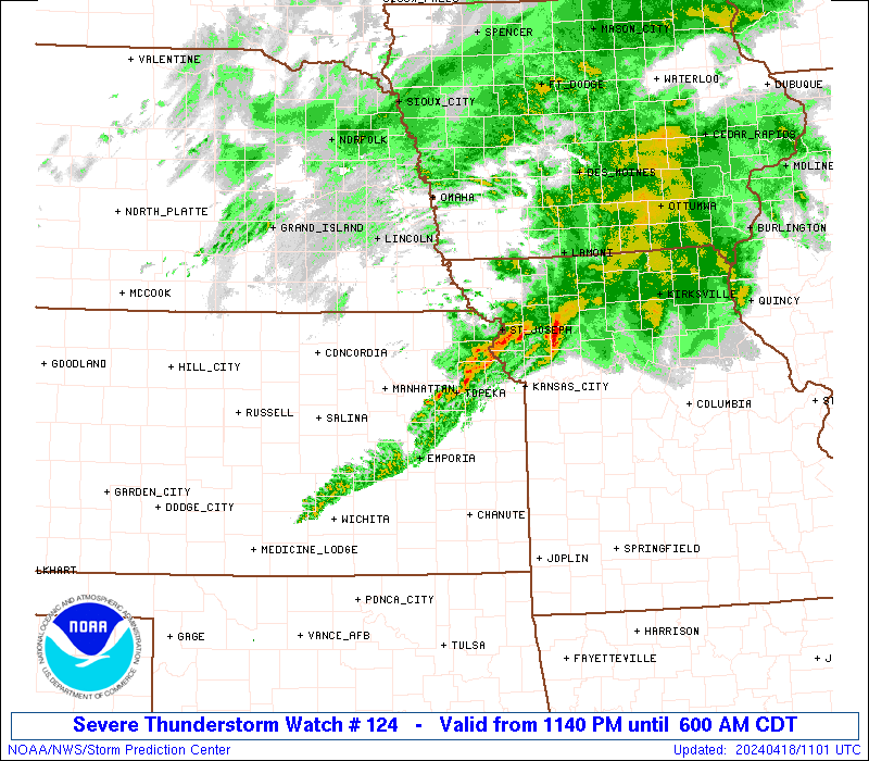
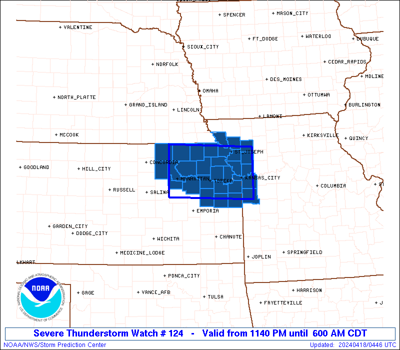
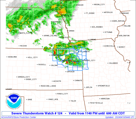
Severe Thunderstorm Watch Number 124
NWS Storm Prediction Center Norman OK
1140 PM CDT Wed Apr 17 2024
The NWS Storm Prediction Center has issued a
* Severe Thunderstorm Watch for portions of
Northeast Kansas
Western and Northwest Missouri
* Effective this Wednesday night and Thursday morning from 1140
PM until 600 AM CDT.
* Primary threats include...
Scattered large hail and isolated very large hail events to 2.5
inches in diameter possible
Isolated damaging wind gusts to 65 mph possible
SUMMARY...Storms will continue to increase and intensify across
northeast Kansas into western/northwest Missouri overnight,
including the I-70 corridor and potentially the Kansas City Metro
area. Large hail can be expected with the most intense storms, and
locally strong wind gusts could also occur.
The severe thunderstorm watch area is approximately along and 45
statute miles north and south of a line from 20 miles northwest of
Manhattan KS to 20 miles east northeast of Kansas City MO. For a
complete depiction of the watch see the associated watch outline
update (WOUS64 KWNS WOU4).
PRECAUTIONARY/PREPAREDNESS ACTIONS...
REMEMBER...A Severe Thunderstorm Watch means conditions are
favorable for severe thunderstorms in and close to the watch area.
Persons in these areas should be on the lookout for threatening
weather conditions and listen for later statements and possible
warnings. Severe thunderstorms can and occasionally do produce
tornadoes.
&&
AVIATION...A few severe thunderstorms with hail surface and aloft to
2.5 inches. Extreme turbulence and surface wind gusts to 55 knots. A
few cumulonimbi with maximum tops to 500. Mean storm motion vector
27025.
...Guyer

   SEL4

   URGENT - IMMEDIATE BROADCAST REQUESTED
   Severe Thunderstorm Watch Number 124
   NWS Storm Prediction Center Norman OK
   1140 PM CDT Wed Apr 17 2024

   The NWS Storm Prediction Center has issued a

   * Severe Thunderstorm Watch for portions of
     Northeast Kansas
     Western and Northwest Missouri

   * Effective this Wednesday night and Thursday morning from 1140
     PM until 600 AM CDT.

   * Primary threats include...
     Scattered large hail and isolated very large hail events to 2.5
       inches in diameter possible
     Isolated damaging wind gusts to 65 mph possible

   SUMMARY...Storms will continue to increase and intensify across
   northeast Kansas into western/northwest Missouri overnight,
   including the I-70 corridor and potentially the Kansas City Metro
   area. Large hail can be expected with the most intense storms, and
   locally strong wind gusts could also occur.

   The severe thunderstorm watch area is approximately along and 45
   statute miles north and south of a line from 20 miles northwest of
   Manhattan KS to 20 miles east northeast of Kansas City MO. For a
   complete depiction of the watch see the associated watch outline
   update (WOUS64 KWNS WOU4).

   PRECAUTIONARY/PREPAREDNESS ACTIONS...

   REMEMBER...A Severe Thunderstorm Watch means conditions are
   favorable for severe thunderstorms in and close to the watch area.
   Persons in these areas should be on the lookout for threatening
   weather conditions and listen for later statements and possible
   warnings. Severe thunderstorms can and occasionally do produce
   tornadoes.

   &&

   AVIATION...A few severe thunderstorms with hail surface and aloft to
   2.5 inches. Extreme turbulence and surface wind gusts to 55 knots. A
   few cumulonimbi with maximum tops to 500. Mean storm motion vector
   27025.

   ...Guyer
 Note:
The Aviation Watch (SAW) product is an approximation to the watch area.
The actual watch is depicted by the shaded areas.
Note:
The Aviation Watch (SAW) product is an approximation to the watch area.
The actual watch is depicted by the shaded areas.
   SAW4
   WW 124 SEVERE TSTM KS MO 180440Z - 181100Z
   AXIS..45 STATUTE MILES NORTH AND SOUTH OF LINE..
   20NW MHK/MANHATTAN KS/ - 20ENE MKC/KANSAS CITY MO/
   ..AVIATION COORDS.. 40NM N/S /40NE SLN - 23E MCI/
   HAIL SURFACE AND ALOFT..2.5 INCHES. WIND GUSTS..55 KNOTS.
   MAX TOPS TO 500. MEAN STORM MOTION VECTOR 27025.

   LAT...LON 39999693 39879425 38579425 38689693

   THIS IS AN APPROXIMATION TO THE WATCH AREA.  FOR A
   COMPLETE DEPICTION OF THE WATCH SEE WOUS64 KWNS
   FOR WOU4.
Watch 124 Status Report Messages:
STATUS REPORT #6 ON WW 124
VALID 181030Z - 181100Z
SEVERE WEATHER THREAT CONTINUES RIGHT OF A LINE FROM 20 NNW EMP
TO 10 NE FLV TO 20 E STJ TO 30 W CDJ.
WW 124 WILL BE ALLOWED TO EXPIRE AT 181100Z.
..GLEASON..04/18/24
ATTN...WFO...EAX...TOP...
&&
STATUS REPORT FOR WS 124
SEVERE WEATHER THREAT CONTINUES FOR THE FOLLOWING AREAS
KSC045-059-091-103-121-139-209-181100-
KS
. KANSAS COUNTIES INCLUDED ARE
DOUGLAS FRANKLIN JOHNSON
LEAVENWORTH MIAMI OSAGE
WYANDOTTE
$$
MOC021-025-037-047-049-095-101-107-165-177-181100-
MO
. MISSOURI COUNTIES INCLUDED ARE
BUCHANAN CALDWELL CASS
CLAY CLINTON JACKSON
JOHNSON LAFAYETTE PLATTE
RAY
$$
THE WATCH STATUS MESSAGE IS FOR GUIDANCE PURPOSES ONLY. PLEASE
REFER TO WATCH COUNTY NOTIFICATION STATEMENTS FOR OFFICIAL
INFORMATION ON COUNTIES...INDEPENDENT CITIES AND MARINE ZONES
CLEARED FROM SEVERE THUNDERSTORM AND TORNADO WATCHES.
$$
STATUS REPORT #5 ON WW 124
VALID 180935Z - 181040Z
SEVERE WEATHER THREAT CONTINUES RIGHT OF A LINE FROM 25 W MHK TO
35 NE MHK TO 30 WSW STJ TO 35 NE STJ.
..GLEASON..04/18/24
ATTN...WFO...EAX...TOP...
&&
STATUS REPORT FOR WS 124
SEVERE WEATHER THREAT CONTINUES FOR THE FOLLOWING AREAS
KSC005-043-045-059-061-085-087-091-103-121-139-149-161-177-197-
209-181040-
KS
. KANSAS COUNTIES INCLUDED ARE
ATCHISON DONIPHAN DOUGLAS
FRANKLIN GEARY JACKSON
JEFFERSON JOHNSON LEAVENWORTH
MIAMI OSAGE POTTAWATOMIE
RILEY SHAWNEE WABAUNSEE
WYANDOTTE
$$
MOC003-021-025-037-047-049-063-095-101-107-165-177-181040-
MO
. MISSOURI COUNTIES INCLUDED ARE
ANDREW BUCHANAN CALDWELL
CASS CLAY CLINTON
DEKALB JACKSON JOHNSON
LAFAYETTE PLATTE RAY
$$
THE WATCH STATUS MESSAGE IS FOR GUIDANCE PURPOSES ONLY. PLEASE
REFER TO WATCH COUNTY NOTIFICATION STATEMENTS FOR OFFICIAL
INFORMATION ON COUNTIES...INDEPENDENT CITIES AND MARINE ZONES
CLEARED FROM SEVERE THUNDERSTORM AND TORNADO WATCHES.
$$
STATUS REPORT #4 ON WW 124
VALID 180835Z - 180940Z
SEVERE WEATHER THREAT CONTINUES RIGHT OF A LINE FROM 25 NNE SLN
TO 25 N MHK TO 25 W FNB.
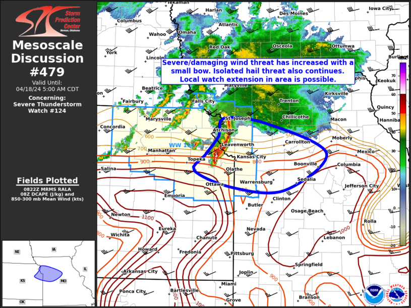
FOR ADDITIONAL INFORMATION SEE MESOSCALE DISCUSSION 479
..GLEASON..04/18/24
ATTN...WFO...EAX...TOP...
&&
STATUS REPORT FOR WS 124
SEVERE WEATHER THREAT CONTINUES FOR THE FOLLOWING AREAS
KSC005-013-027-043-045-059-061-085-087-091-103-117-121-131-139-
149-161-177-197-209-180940-
KS
. KANSAS COUNTIES INCLUDED ARE
ATCHISON BROWN CLAY
DONIPHAN DOUGLAS FRANKLIN
GEARY JACKSON JEFFERSON
JOHNSON LEAVENWORTH MARSHALL
MIAMI NEMAHA OSAGE
POTTAWATOMIE RILEY SHAWNEE
WABAUNSEE WYANDOTTE
$$
MOC003-021-037-047-049-063-087-095-165-180940-
MO
. MISSOURI COUNTIES INCLUDED ARE
ANDREW BUCHANAN CASS
CLAY CLINTON DEKALB
HOLT JACKSON PLATTE
$$
THE WATCH STATUS MESSAGE IS FOR GUIDANCE PURPOSES ONLY. PLEASE
REFER TO WATCH COUNTY NOTIFICATION STATEMENTS FOR OFFICIAL
INFORMATION ON COUNTIES...INDEPENDENT CITIES AND MARINE ZONES
CLEARED FROM SEVERE THUNDERSTORM AND TORNADO WATCHES.
$$
STATUS REPORT #3 ON WW 124
VALID 180745Z - 180840Z
THE SEVERE WEATHER THREAT CONTINUES ACROSS THE ENTIRE WATCH AREA.
FOR ADDITIONAL INFORMATION SEE MESOSCALE DISCUSSION 478
..GLEASON..04/18/24
ATTN...WFO...EAX...TOP...
&&
STATUS REPORT FOR WS 124
SEVERE WEATHER THREAT CONTINUES FOR THE FOLLOWING AREAS
KSC005-013-027-043-045-059-061-085-087-091-103-117-121-131-139-
149-161-177-197-201-209-180840-
KS
. KANSAS COUNTIES INCLUDED ARE
ATCHISON BROWN CLAY
DONIPHAN DOUGLAS FRANKLIN
GEARY JACKSON JEFFERSON
JOHNSON LEAVENWORTH MARSHALL
MIAMI NEMAHA OSAGE
POTTAWATOMIE RILEY SHAWNEE
WABAUNSEE WASHINGTON WYANDOTTE
$$
MOC003-021-037-047-049-063-087-095-165-180840-
MO
. MISSOURI COUNTIES INCLUDED ARE
ANDREW BUCHANAN CASS
CLAY CLINTON DEKALB
HOLT JACKSON PLATTE
$$
THE WATCH STATUS MESSAGE IS FOR GUIDANCE PURPOSES ONLY. PLEASE
REFER TO WATCH COUNTY NOTIFICATION STATEMENTS FOR OFFICIAL
INFORMATION ON COUNTIES...INDEPENDENT CITIES AND MARINE ZONES
CLEARED FROM SEVERE THUNDERSTORM AND TORNADO WATCHES.
$$
STATUS REPORT #2 ON WW 124
VALID 180635Z - 180740Z
THE SEVERE WEATHER THREAT CONTINUES ACROSS THE ENTIRE WATCH AREA.
..GLEASON..04/18/24
ATTN...WFO...EAX...TOP...
&&
STATUS REPORT FOR WS 124
SEVERE WEATHER THREAT CONTINUES FOR THE FOLLOWING AREAS
KSC005-013-027-043-045-059-061-085-087-091-103-117-121-131-139-
149-161-177-197-201-209-180740-
KS
. KANSAS COUNTIES INCLUDED ARE
ATCHISON BROWN CLAY
DONIPHAN DOUGLAS FRANKLIN
GEARY JACKSON JEFFERSON
JOHNSON LEAVENWORTH MARSHALL
MIAMI NEMAHA OSAGE
POTTAWATOMIE RILEY SHAWNEE
WABAUNSEE WASHINGTON WYANDOTTE
$$
MOC003-021-037-047-049-063-087-095-165-180740-
MO
. MISSOURI COUNTIES INCLUDED ARE
ANDREW BUCHANAN CASS
CLAY CLINTON DEKALB
HOLT JACKSON PLATTE
$$
THE WATCH STATUS MESSAGE IS FOR GUIDANCE PURPOSES ONLY. PLEASE
REFER TO WATCH COUNTY NOTIFICATION STATEMENTS FOR OFFICIAL
INFORMATION ON COUNTIES...INDEPENDENT CITIES AND MARINE ZONES
CLEARED FROM SEVERE THUNDERSTORM AND TORNADO WATCHES.
$$
STATUS REPORT #1 ON WW 124
VALID 180520Z - 180640Z
THE SEVERE WEATHER THREAT CONTINUES ACROSS THE ENTIRE WATCH AREA.
..GLEASON..04/18/24
ATTN...WFO...EAX...TOP...
&&
STATUS REPORT FOR WS 124
SEVERE WEATHER THREAT CONTINUES FOR THE FOLLOWING AREAS
KSC005-013-027-043-045-059-061-085-087-091-103-117-121-131-139-
149-161-177-197-201-209-180640-
KS
. KANSAS COUNTIES INCLUDED ARE
ATCHISON BROWN CLAY
DONIPHAN DOUGLAS FRANKLIN
GEARY JACKSON JEFFERSON
JOHNSON LEAVENWORTH MARSHALL
MIAMI NEMAHA OSAGE
POTTAWATOMIE RILEY SHAWNEE
WABAUNSEE WASHINGTON WYANDOTTE
$$
MOC003-021-037-047-049-063-087-095-165-180640-
MO
. MISSOURI COUNTIES INCLUDED ARE
ANDREW BUCHANAN CASS
CLAY CLINTON DEKALB
HOLT JACKSON PLATTE
$$
THE WATCH STATUS MESSAGE IS FOR GUIDANCE PURPOSES ONLY. PLEASE
REFER TO WATCH COUNTY NOTIFICATION STATEMENTS FOR OFFICIAL
INFORMATION ON COUNTIES...INDEPENDENT CITIES AND MARINE ZONES
CLEARED FROM SEVERE THUNDERSTORM AND TORNADO WATCHES.
$$
Note:
Click for Complete Product Text.
Tornadoes
Probability of 2 or more tornadoes
|
Low (10%)
|
Probability of 1 or more strong (EF2-EF5) tornadoes
|
Low (5%)
|
Wind
Probability of 10 or more severe wind events
|
Mod (30%)
|
Probability of 1 or more wind events > 65 knots
|
Low (20%)
|
Hail
Probability of 10 or more severe hail events
|
Mod (50%)
|
Probability of 1 or more hailstones > 2 inches
|
Mod (30%)
|
Combined Severe Hail/Wind
Probability of 6 or more combined severe hail/wind events
|
High (80%)
|
For each watch, probabilities for particular events inside the watch
(listed above in each table) are determined by the issuing forecaster.
The "Low" category contains probability values ranging from less than 2%
to 20% (EF2-EF5 tornadoes), less than 5% to 20% (all other probabilities),
"Moderate" from 30% to 60%, and "High" from 70% to greater than 95%.
High values are bolded and lighter in color to provide awareness of
an increased threat for a particular event.


 @NWSSPC