|
| Mesoscale Discussion 479 |
|
< Previous MD Next MD >
|
|
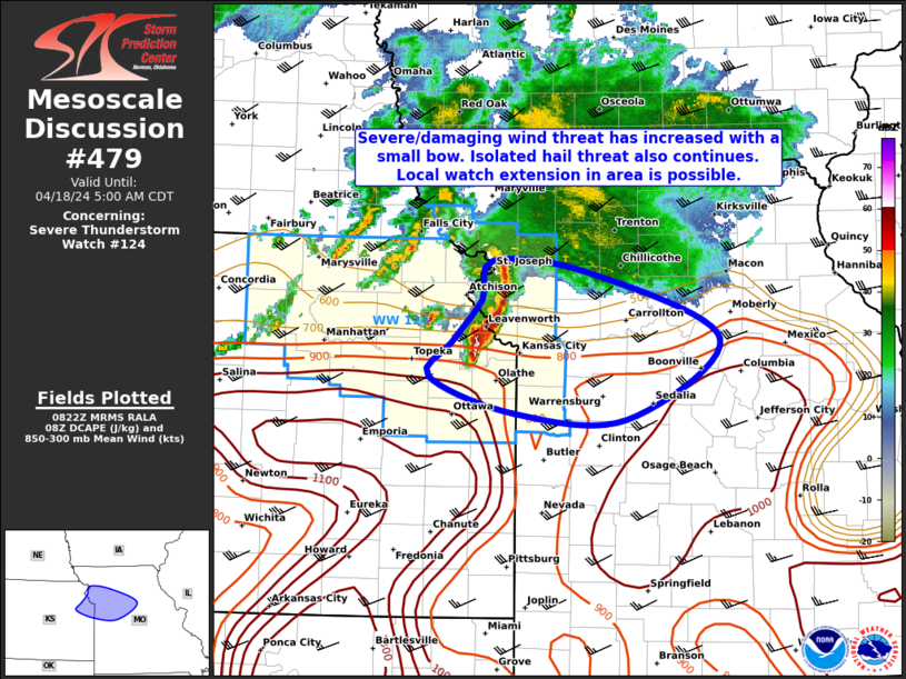
   Mesoscale Discussion 0479
   NWS Storm Prediction Center Norman OK
   0325 AM CDT Thu Apr 18 2024

   Areas affected...Portions of northeast KS into western/central MO

   Concerning...Severe Thunderstorm Watch 124...

   Valid 180825Z - 181000Z

   The severe weather threat for Severe Thunderstorm Watch 124
   continues.

   SUMMARY...The severe/damaging wind threat has increased with a small
   bow moving eastward. An isolated hail threat also continues. Local
   watch extension (in area) is possible.

   DISCUSSION...Mainly supercell structures over northeast KS have
   evolved into a small bowing complex over the past hour or so. This
   convection is approaching the Kansas City metro in the near term,
   and should pose a continued severe/damaging wind threat. Gusts up to
   around 70 mph may occur given the well organized nature of the bow,
   even as low-level static stability attempts to hinder convective
   downdrafts from reaching the surface. Isolated severe hail also
   appears possible, as strong reflectivity aloft associated with an
   embedded supercell persists on the southern flank of the bow. Given
   a current eastward motion around 35-40 kt, a local extension in area
   for Severe Thunderstorm Watch 124 to include more of western/central
   MO may be needed. Still, the eastward extent of the severe threat
   remain somewhat uncertain, as less MUCAPE is present farther east.
   However, greater DCAPE is present into central MO, which may support
   a continued severe wind threat through the early morning hours.

   ..Gleason.. 04/18/2024

   ...Please see www.spc.noaa.gov for graphic product...

   ATTN...WFO...EAX...TOP...

   LAT...LON   39179527 39529496 39829484 39739388 39209253 38579348
               38619463 38909550 39179527
|
|
Top/All Mesoscale Discussions/Forecast Products/Home
|
|


 @NWSSPC