 Note:
The expiration time in the watch graphic is amended if the watch is
replaced, cancelled or extended.
Note:
Note:
The expiration time in the watch graphic is amended if the watch is
replaced, cancelled or extended.
Note: Click for
Watch Status Reports.
SEL7
URGENT - IMMEDIATE BROADCAST REQUESTED
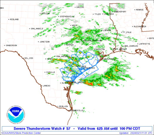
Severe Thunderstorm Watch Number 57
NWS Storm Prediction Center Norman OK
625 AM CDT Thu Mar 21 2024
The NWS Storm Prediction Center has issued a
* Severe Thunderstorm Watch for portions of
Middle Texas Coastal Plain
Coastal Waters
* Effective this Thursday morning and afternoon from 625 AM until
100 PM CDT.
* Primary threats include...
Scattered large hail and isolated very large hail events to 2
inches in diameter possible
Isolated damaging wind gusts to 60 mph possible
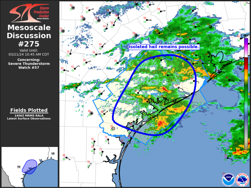
SUMMARY...Thunderstorms will increase in coverage/intensity this
morning while spreading east and northeastward near the middle Texas
Coast. A couple of slightly elevated supercells will be possible,
with the potential to produce 1-2 inch diameter hail and isolated
damaging gusts near 60 mph.
The severe thunderstorm watch area is approximately along and 50
statute miles east and west of a line from 50 miles south of
Victoria TX to 45 miles northwest of Angleton TX. For a complete
depiction of the watch see the associated watch outline update
(WOUS64 KWNS WOU7).
PRECAUTIONARY/PREPAREDNESS ACTIONS...
REMEMBER...A Severe Thunderstorm Watch means conditions are
favorable for severe thunderstorms in and close to the watch area.
Persons in these areas should be on the lookout for threatening
weather conditions and listen for later statements and possible
warnings. Severe thunderstorms can and occasionally do produce
tornadoes.
&&
AVIATION...A few severe thunderstorms with hail surface and aloft to
2 inches. Extreme turbulence and surface wind gusts to 50 knots. A
few cumulonimbi with maximum tops to 500. Mean storm motion vector
26020.
...Thompson

   SEL7

   URGENT - IMMEDIATE BROADCAST REQUESTED
   Severe Thunderstorm Watch Number 57
   NWS Storm Prediction Center Norman OK
   625 AM CDT Thu Mar 21 2024

   The NWS Storm Prediction Center has issued a

   * Severe Thunderstorm Watch for portions of
     Middle Texas Coastal Plain
     Coastal Waters

   * Effective this Thursday morning and afternoon from 625 AM until
     100 PM CDT.

   * Primary threats include...
     Scattered large hail and isolated very large hail events to 2
       inches in diameter possible
     Isolated damaging wind gusts to 60 mph possible

   SUMMARY...Thunderstorms will increase in coverage/intensity this
   morning while spreading east and northeastward near the middle Texas
   Coast.  A couple of slightly elevated supercells will be possible,
   with the potential to produce 1-2 inch diameter hail and isolated
   damaging gusts near 60 mph.

   The severe thunderstorm watch area is approximately along and 50
   statute miles east and west of a line from 50 miles south of
   Victoria TX to 45 miles northwest of Angleton TX. For a complete
   depiction of the watch see the associated watch outline update
   (WOUS64 KWNS WOU7).

   PRECAUTIONARY/PREPAREDNESS ACTIONS...

   REMEMBER...A Severe Thunderstorm Watch means conditions are
   favorable for severe thunderstorms in and close to the watch area.
   Persons in these areas should be on the lookout for threatening
   weather conditions and listen for later statements and possible
   warnings. Severe thunderstorms can and occasionally do produce
   tornadoes.

   &&

   AVIATION...A few severe thunderstorms with hail surface and aloft to
   2 inches. Extreme turbulence and surface wind gusts to 50 knots. A
   few cumulonimbi with maximum tops to 500. Mean storm motion vector
   26020.

   ...Thompson
 Note:
The Aviation Watch (SAW) product is an approximation to the watch area.
The actual watch is depicted by the shaded areas.
Note:
The Aviation Watch (SAW) product is an approximation to the watch area.
The actual watch is depicted by the shaded areas.
   SAW7
   WW 57 SEVERE TSTM TX CW 211125Z - 211800Z
   AXIS..50 STATUTE MILES EAST AND WEST OF LINE..
   50S VCT/VICTORIA TX/ - 45NW LBX/ANGLETON TX/
   ..AVIATION COORDS.. 45NM E/W /31ENE CRP - 41SW IAH/
   HAIL SURFACE AND ALOFT..2 INCHES. WIND GUSTS..50 KNOTS.
   MAX TOPS TO 500. MEAN STORM MOTION VECTOR 26020.

   LAT...LON 28129774 29589683 29589517 28129610

   THIS IS AN APPROXIMATION TO THE WATCH AREA.  FOR A
   COMPLETE DEPICTION OF THE WATCH SEE WOUS64 KWNS
   FOR WOU7.
Watch 57 Status Report Messages:
STATUS REPORT #1 ON WW 57

VALID 211225Z - 211340Z

THE SEVERE WEATHER THREAT CONTINUES ACROSS THE ENTIRE WATCH AREA.

..GRAMS..03/21/24

ATTN...WFO...CRP...HGX...EWX...

&&

STATUS REPORT FOR WS 57

SEVERE WEATHER THREAT CONTINUES FOR THE FOLLOWING AREAS

TXC007-025-039-057-089-123-157-175-239-285-321-391-409-469-481-
211340-

TX
.    TEXAS COUNTIES INCLUDED ARE

ARANSAS 	     BEE		 BRAZORIA
CALHOUN 	     COLORADO		 DEWITT
FORT BEND	     GOLIAD		 JACKSON
LAVACA		     MATAGORDA		 REFUGIO
SAN PATRICIO	     VICTORIA		 WHARTON
$$


GMZ236-237-255-330-350-211340-

CW

.    ADJACENT COASTAL WATERS INCLUDED ARE

COPANO ARANSAS AND REDFISH BAYS

SAN ANTONIO MESQUITE AND ESPIRITU SANTO BAYS

COASTAL WATERS FROM PORT ARANSAS TO MATAGORDA SHIP CHANNEL OUT 20
NM

MATAGORDA BAY

COASTAL WATERS FROM FREEPORT TO MATAGORDA SHIP CHANNEL TX OUT 20
NM

$$
THE WATCH STATUS MESSAGE IS FOR GUIDANCE PURPOSES ONLY.  PLEASE
REFER TO WATCH COUNTY NOTIFICATION STATEMENTS FOR OFFICIAL
INFORMATION ON COUNTIES...INDEPENDENT CITIES AND MARINE ZONES
CLEARED FROM SEVERE THUNDERSTORM AND TORNADO WATCHES.
$$
Note:
Click for Complete Product Text.
Tornadoes
Probability of 2 or more tornadoes
|
Low (10%)
|
Probability of 1 or more strong (EF2-EF5) tornadoes
|
Low (<2%)
|
Wind
Probability of 10 or more severe wind events
|
Low (20%)
|
Probability of 1 or more wind events > 65 knots
|
Low (10%)
|
Hail
Probability of 10 or more severe hail events
|
Mod (40%)
|
Probability of 1 or more hailstones > 2 inches
|
Mod (30%)
|
Combined Severe Hail/Wind
Probability of 6 or more combined severe hail/wind events
|
Mod (60%)
|
For each watch, probabilities for particular events inside the watch
(listed above in each table) are determined by the issuing forecaster.
The "Low" category contains probability values ranging from less than 2%
to 20% (EF2-EF5 tornadoes), less than 5% to 20% (all other probabilities),
"Moderate" from 30% to 60%, and "High" from 70% to greater than 95%.
High values are bolded and lighter in color to provide awareness of
an increased threat for a particular event.


 @NWSSPC