 Note:
The expiration time in the watch graphic is amended if the watch is
replaced, cancelled or extended.
Note:
Note:
The expiration time in the watch graphic is amended if the watch is
replaced, cancelled or extended.
Note: Click for
Watch Status Reports.
SEL6
URGENT - IMMEDIATE BROADCAST REQUESTED
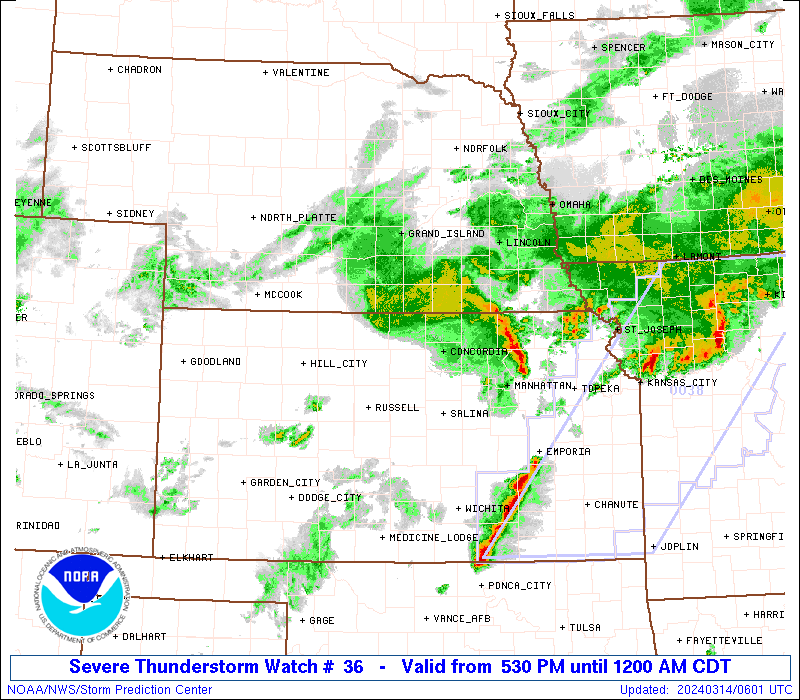
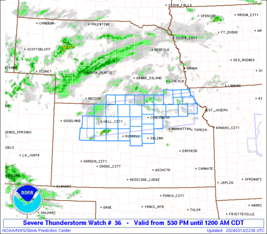
Severe Thunderstorm Watch Number 36
NWS Storm Prediction Center Norman OK
530 PM CDT Wed Mar 13 2024
The NWS Storm Prediction Center has issued a
* Severe Thunderstorm Watch for portions of
Northern Kansas
Southern Nebraska
* Effective this Wednesday afternoon from 530 PM until Midnight
CDT.
* Primary threats include...
Scattered large hail and isolated very large hail events to 2
inches in diameter likely
Scattered damaging wind gusts to 65 mph possible
A tornado or two possible
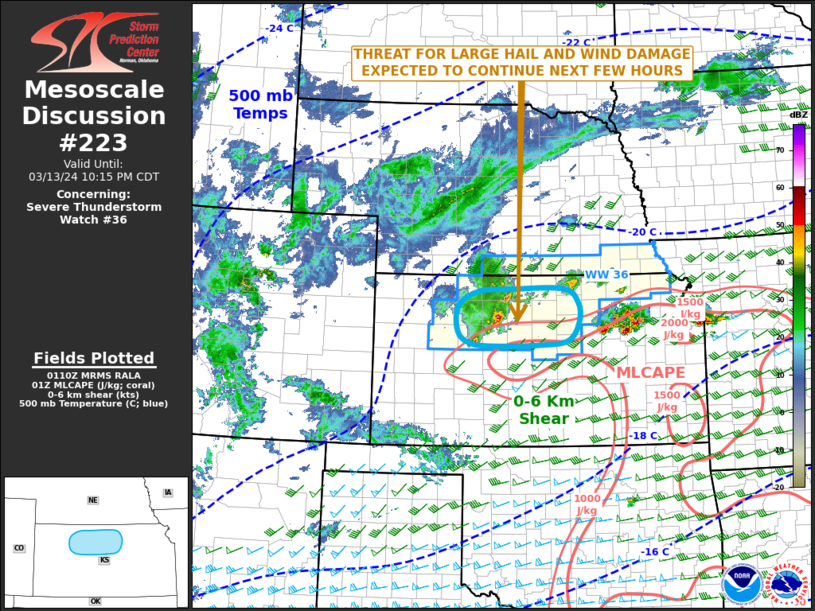
SUMMARY...Thunderstorms will increase in coverage and intensity
through the late afternoon and evening across the watch area. A few
of the storms will likely become severe, with large hail the primary
concern.
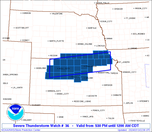
The severe thunderstorm watch area is approximately along and 40
statute miles north and south of a line from 35 miles west of Hill
City KS to 15 miles south southeast of Falls City NE. For a complete
depiction of the watch see the associated watch outline update
(WOUS64 KWNS WOU6).
PRECAUTIONARY/PREPAREDNESS ACTIONS...
REMEMBER...A Severe Thunderstorm Watch means conditions are
favorable for severe thunderstorms in and close to the watch area.
Persons in these areas should be on the lookout for threatening
weather conditions and listen for later statements and possible
warnings. Severe thunderstorms can and occasionally do produce
tornadoes.
&&
OTHER WATCH INFORMATION...CONTINUE...WW 35...
AVIATION...A few severe thunderstorms with hail surface and aloft to
2 inches. Extreme turbulence and surface wind gusts to 55 knots. A
few cumulonimbi with maximum tops to 450. Mean storm motion vector
25030.
...Hart

   SEL6

   URGENT - IMMEDIATE BROADCAST REQUESTED
   Severe Thunderstorm Watch Number 36
   NWS Storm Prediction Center Norman OK
   530 PM CDT Wed Mar 13 2024

   The NWS Storm Prediction Center has issued a

   * Severe Thunderstorm Watch for portions of
     Northern Kansas
     Southern Nebraska

   * Effective this Wednesday afternoon from 530 PM until Midnight
     CDT.

   * Primary threats include...
     Scattered large hail and isolated very large hail events to 2
       inches in diameter likely
     Scattered damaging wind gusts to 65 mph possible
     A tornado or two possible

   SUMMARY...Thunderstorms will increase in coverage and intensity
   through the late afternoon and evening across the watch area.  A few
   of the storms will likely become severe, with large hail the primary
   concern.

   The severe thunderstorm watch area is approximately along and 40
   statute miles north and south of a line from 35 miles west of Hill
   City KS to 15 miles south southeast of Falls City NE. For a complete
   depiction of the watch see the associated watch outline update
   (WOUS64 KWNS WOU6).

   PRECAUTIONARY/PREPAREDNESS ACTIONS...

   REMEMBER...A Severe Thunderstorm Watch means conditions are
   favorable for severe thunderstorms in and close to the watch area.
   Persons in these areas should be on the lookout for threatening
   weather conditions and listen for later statements and possible
   warnings. Severe thunderstorms can and occasionally do produce
   tornadoes.

   &&

   OTHER WATCH INFORMATION...CONTINUE...WW 35...

   AVIATION...A few severe thunderstorms with hail surface and aloft to
   2 inches. Extreme turbulence and surface wind gusts to 55 knots. A
   few cumulonimbi with maximum tops to 450. Mean storm motion vector
   25030.

   ...Hart
 Note:
The Aviation Watch (SAW) product is an approximation to the watch area.
The actual watch is depicted by the shaded areas.
Note:
The Aviation Watch (SAW) product is an approximation to the watch area.
The actual watch is depicted by the shaded areas.
   SAW6
   WW 36 SEVERE TSTM KS NE 132230Z - 140500Z
   AXIS..40 STATUTE MILES NORTH AND SOUTH OF LINE..
   35W HLC/HILL CITY KS/ - 15SSE FNB/FALLS CITY NE/
   ..AVIATION COORDS.. 35NM N/S /14WNW HLC - 39ESE PWE/
   HAIL SURFACE AND ALOFT..2 INCHES. WIND GUSTS..55 KNOTS.
   MAX TOPS TO 450. MEAN STORM MOTION VECTOR 25030.

   LAT...LON 39960049 40459549 39299549 38800049

   THIS IS AN APPROXIMATION TO THE WATCH AREA.  FOR A
   COMPLETE DEPICTION OF THE WATCH SEE WOUS64 KWNS
   FOR WOU6.
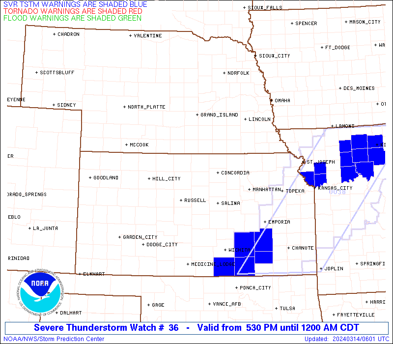
Watch 36 Status Report Messages:
STATUS REPORT #5 ON WW 36

VALID 140440Z - 140540Z

SEVERE WEATHER THREAT CONTINUES RIGHT OF A LINE FROM 25 NNW HUT
TO 15 WSW CNK TO 25 ESE HSI.

..BROYLES..03/14/24

ATTN...WFO...TOP...DDC...ICT...GLD...GID...OAX...

&&

STATUS REPORT FOR WS 36

SEVERE WEATHER THREAT CONTINUES FOR THE FOLLOWING AREAS

KSC013-027-029-117-131-143-157-169-201-140540-

KS
.    KANSAS COUNTIES INCLUDED ARE

BROWN		     CLAY		 CLOUD
MARSHALL	     NEMAHA		 OTTAWA
REPUBLIC	     SALINE		 WASHINGTON
$$


NEC067-095-097-127-133-147-169-140540-

NE
.    NEBRASKA COUNTIES INCLUDED ARE

GAGE		     JEFFERSON		 JOHNSON
NEMAHA		     PAWNEE		 RICHARDSON
THAYER
$$


THE WATCH STATUS MESSAGE IS FOR GUIDANCE PURPOSES ONLY.  PLEASE
REFER TO WATCH COUNTY NOTIFICATION STATEMENTS FOR OFFICIAL
INFORMATION ON COUNTIES...INDEPENDENT CITIES AND MARINE ZONES
CLEARED FROM SEVERE THUNDERSTORM AND TORNADO WATCHES.
$$

STATUS REPORT #4 ON WW 36

VALID 140245Z - 140340Z

SEVERE WEATHER THREAT CONTINUES RIGHT OF A LINE FROM 55 S HLC TO
50 ENE HLC TO 20 ESE HSI.

..BROYLES..03/14/24

ATTN...WFO...TOP...DDC...ICT...GLD...GID...OAX...

&&

STATUS REPORT FOR WS 36

SEVERE WEATHER THREAT CONTINUES FOR THE FOLLOWING AREAS

KSC013-027-029-051-053-089-105-117-123-131-141-143-157-167-169-
183-201-140340-

KS
.    KANSAS COUNTIES INCLUDED ARE

BROWN		     CLAY		 CLOUD
ELLIS		     ELLSWORTH		 JEWELL
LINCOLN 	     MARSHALL		 MITCHELL
NEMAHA		     OSBORNE		 OTTAWA
REPUBLIC	     RUSSELL		 SALINE
SMITH		     WASHINGTON
$$


NEC067-095-097-127-129-133-147-169-140340-

NE
.    NEBRASKA COUNTIES INCLUDED ARE

GAGE		     JEFFERSON		 JOHNSON
NEMAHA		     NUCKOLLS		 PAWNEE
RICHARDSON	     THAYER
$$


THE WATCH STATUS MESSAGE IS FOR GUIDANCE PURPOSES ONLY.  PLEASE
REFER TO WATCH COUNTY NOTIFICATION STATEMENTS FOR OFFICIAL
INFORMATION ON COUNTIES...INDEPENDENT CITIES AND MARINE ZONES
CLEARED FROM SEVERE THUNDERSTORM AND TORNADO WATCHES.
$$

STATUS REPORT #3 ON WW 36

VALID 140215Z - 140340Z

SEVERE WEATHER THREAT CONTINUES RIGHT OF A LINE FROM 50 SSW HLC
TO 55 NNE GCK TO 25 ENE HLC TO 10 S HSI.

..BROYLES..03/14/24

ATTN...WFO...TOP...DDC...ICT...GLD...GID...OAX...

&&

STATUS REPORT FOR WS 36

SEVERE WEATHER THREAT CONTINUES FOR THE FOLLOWING AREAS

KSC013-027-029-051-053-089-105-117-123-131-141-143-157-163-167-
169-183-195-201-140340-

KS
.    KANSAS COUNTIES INCLUDED ARE

BROWN		     CLAY		 CLOUD
ELLIS		     ELLSWORTH		 JEWELL
LINCOLN 	     MARSHALL		 MITCHELL
NEMAHA		     OSBORNE		 OTTAWA
REPUBLIC	     ROOKS		 RUSSELL
SALINE		     SMITH		 TREGO
WASHINGTON
$$


NEC067-095-097-127-129-133-147-169-181-140340-

NE
.    NEBRASKA COUNTIES INCLUDED ARE

GAGE		     JEFFERSON		 JOHNSON
NEMAHA		     NUCKOLLS		 PAWNEE
RICHARDSON	     THAYER		 WEBSTER
$$


THE WATCH STATUS MESSAGE IS FOR GUIDANCE PURPOSES ONLY.  PLEASE
REFER TO WATCH COUNTY NOTIFICATION STATEMENTS FOR OFFICIAL
INFORMATION ON COUNTIES...INDEPENDENT CITIES AND MARINE ZONES
CLEARED FROM SEVERE THUNDERSTORM AND TORNADO WATCHES.
$$

STATUS REPORT #2 ON WW 36

VALID 140130Z - 140240Z

SEVERE WEATHER THREAT CONTINUES RIGHT OF A LINE FROM 50 WSW HLC
TO 30 NE HLC TO 20 SSE EAR.

..BROYLES..03/14/24

ATTN...WFO...TOP...DDC...ICT...GLD...GID...OAX...

&&

STATUS REPORT FOR WS 36

SEVERE WEATHER THREAT CONTINUES FOR THE FOLLOWING AREAS

KSC013-027-029-051-053-063-065-089-105-117-123-131-141-143-147-
157-163-167-169-183-195-201-140240-

KS
.    KANSAS COUNTIES INCLUDED ARE

BROWN		     CLAY		 CLOUD
ELLIS		     ELLSWORTH		 GOVE
GRAHAM		     JEWELL		 LINCOLN
MARSHALL	     MITCHELL		 NEMAHA
OSBORNE 	     OTTAWA		 PHILLIPS
REPUBLIC	     ROOKS		 RUSSELL
SALINE		     SMITH		 TREGO
WASHINGTON
$$


NEC061-067-095-097-127-129-133-147-169-181-140240-

NE
.    NEBRASKA COUNTIES INCLUDED ARE

FRANKLIN	     GAGE		 JEFFERSON
JOHNSON 	     NEMAHA		 NUCKOLLS
PAWNEE		     RICHARDSON 	 THAYER
WEBSTER
$$


THE WATCH STATUS MESSAGE IS FOR GUIDANCE PURPOSES ONLY.  PLEASE
REFER TO WATCH COUNTY NOTIFICATION STATEMENTS FOR OFFICIAL
INFORMATION ON COUNTIES...INDEPENDENT CITIES AND MARINE ZONES
CLEARED FROM SEVERE THUNDERSTORM AND TORNADO WATCHES.
$$

STATUS REPORT #1 ON WW 36

VALID 140030Z - 140140Z

THE SEVERE WEATHER THREAT CONTINUES ACROSS THE ENTIRE WATCH AREA.

..BROYLES..03/14/24

ATTN...WFO...TOP...DDC...ICT...GLD...GID...OAX...

&&

STATUS REPORT FOR WS 36

SEVERE WEATHER THREAT CONTINUES FOR THE FOLLOWING AREAS

KSC013-027-029-051-053-063-065-089-105-117-123-131-137-141-143-
147-157-163-167-169-179-183-195-201-140140-

KS
.    KANSAS COUNTIES INCLUDED ARE

BROWN		     CLAY		 CLOUD
ELLIS		     ELLSWORTH		 GOVE
GRAHAM		     JEWELL		 LINCOLN
MARSHALL	     MITCHELL		 NEMAHA
NORTON		     OSBORNE		 OTTAWA
PHILLIPS	     REPUBLIC		 ROOKS
RUSSELL 	     SALINE		 SHERIDAN
SMITH		     TREGO		 WASHINGTON
$$


NEC061-067-083-095-097-127-129-133-147-169-181-140140-

NE
.    NEBRASKA COUNTIES INCLUDED ARE

FRANKLIN	     GAGE		 HARLAN
JEFFERSON	     JOHNSON		 NEMAHA
NUCKOLLS	     PAWNEE		 RICHARDSON
THAYER		     WEBSTER
$$


THE WATCH STATUS MESSAGE IS FOR GUIDANCE PURPOSES ONLY.  PLEASE
REFER TO WATCH COUNTY NOTIFICATION STATEMENTS FOR OFFICIAL
INFORMATION ON COUNTIES...INDEPENDENT CITIES AND MARINE ZONES
CLEARED FROM SEVERE THUNDERSTORM AND TORNADO WATCHES.
$$
Note:
Click for Complete Product Text.
Tornadoes
Probability of 2 or more tornadoes
|
Low (20%)
|
Probability of 1 or more strong (EF2-EF5) tornadoes
|
Low (5%)
|
Wind
Probability of 10 or more severe wind events
|
Mod (40%)
|
Probability of 1 or more wind events > 65 knots
|
Low (20%)
|
Hail
Probability of 10 or more severe hail events
|
Mod (60%)
|
Probability of 1 or more hailstones > 2 inches
|
Mod (60%)
|
Combined Severe Hail/Wind
Probability of 6 or more combined severe hail/wind events
|
High (90%)
|
For each watch, probabilities for particular events inside the watch
(listed above in each table) are determined by the issuing forecaster.
The "Low" category contains probability values ranging from less than 2%
to 20% (EF2-EF5 tornadoes), less than 5% to 20% (all other probabilities),
"Moderate" from 30% to 60%, and "High" from 70% to greater than 95%.
High values are bolded and lighter in color to provide awareness of
an increased threat for a particular event.


 @NWSSPC