|
| Mesoscale Discussion 223 |
|
< Previous MD Next MD >
|
|
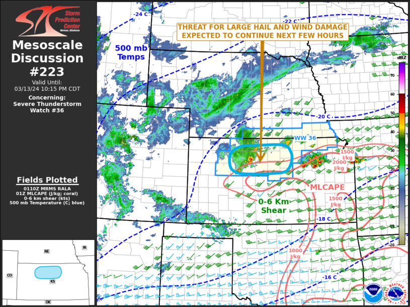
   Mesoscale Discussion 0223
   NWS Storm Prediction Center Norman OK
   0813 PM CDT Wed Mar 13 2024

   Areas affected...North-central Kansas

   Concerning...Severe Thunderstorm Watch 36...

   Valid 140113Z - 140315Z

   The severe weather threat for Severe Thunderstorm Watch 36
   continues.

   SUMMARY...A severe threat will likely continue across parts of
   north-central Kansas for several more hours. Large hail and wind
   damage will be the primary threats.

   DISCUSSION...The latest high-resolution radar imagery from Hastings,
   Nebraska shows a strong to severe convective cluster over Trego and
   Rooks Counties in north-central Kansas. These storms are located
   along an east-to-west gradient of instability, where MLCAPE is
   estimated by the RAP to be near 1000 J/kg. The storms are also
   located along the northern edge of a plume of steep mid-level lapse
   rates, where 700-500 mb lapse rates are estimated to be near 8 C/km.
   This environment, along with moderate deep-layer shear will be
   favorable for supercells with large hail. Hailstones of greater than
   2 inches in diameter will be possible within the more intense cores.
   The severe threat is expected to continue for several more hours, as
   the convective cluster moves east-northeastward across north-central
   Kansas. Additional severe storms with large hail may also develop
   further to the east as low-level flow continues to increase this
   evening.

   ..Broyles.. 03/14/2024

   ...Please see www.spc.noaa.gov for graphic product...

   ATTN...WFO...TOP...ICT...GID...DDC...GLD...

   LAT...LON   38759931 38809987 39010015 39460014 39719970 39759900
               39779777 39539744 39199741 38869765 38779825 38759931
|
|
Top/All Mesoscale Discussions/Forecast Products/Home
|
|


 @NWSSPC