Note:
The expiration time in the watch graphic is amended if the watch is
replaced, cancelled or extended.
Note:
Note:
The expiration time in the watch graphic is amended if the watch is
replaced, cancelled or extended.
Note: Click for
Watch Status Reports.
SEL5
URGENT - IMMEDIATE BROADCAST REQUESTED
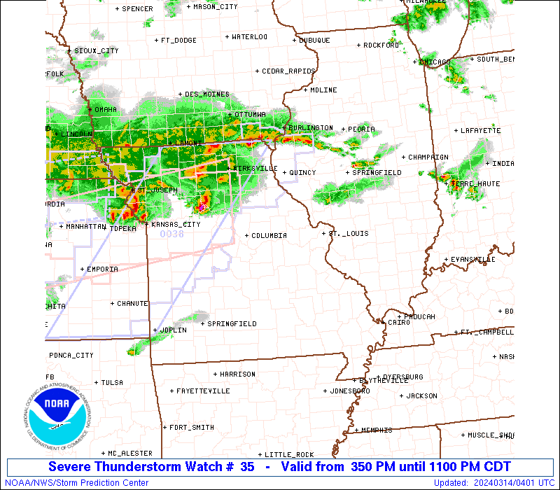
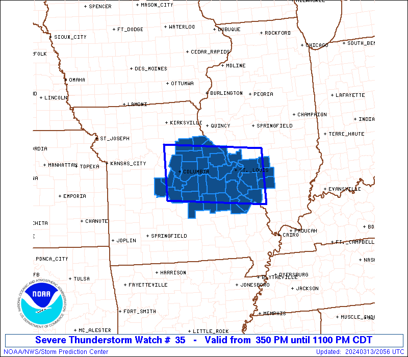
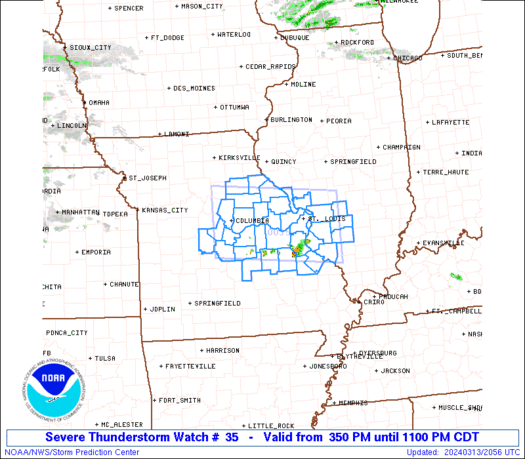
Severe Thunderstorm Watch Number 35
NWS Storm Prediction Center Norman OK
350 PM CDT Wed Mar 13 2024
The NWS Storm Prediction Center has issued a
* Severe Thunderstorm Watch for portions of
Southwest Illinois
Central and Eastern Missouri
* Effective this Wednesday afternoon and evening from 350 PM
until 1100 PM CDT.
* Primary threats include...
Scattered large hail likely with isolated very large hail events
to 2 inches in diameter possible
Isolated damaging wind gusts to 60 mph possible
A tornado or two possible
SUMMARY...Widely scattered strong to severe thunderstorms are
expected to increase across the region late this afternoon through
early evening, including parts of the I-70/I-55 corridors. Large
hail is expected to be the most common risk, with some potential for
damaging winds and possibly a tornado into early evening.
The severe thunderstorm watch area is approximately along and 50
statute miles north and south of a line from 25 miles west of
Columbia MO to 20 miles east of Scott Afb IL. For a complete
depiction of the watch see the associated watch outline update
(WOUS64 KWNS WOU5).
PRECAUTIONARY/PREPAREDNESS ACTIONS...
REMEMBER...A Severe Thunderstorm Watch means conditions are
favorable for severe thunderstorms in and close to the watch area.
Persons in these areas should be on the lookout for threatening
weather conditions and listen for later statements and possible
warnings. Severe thunderstorms can and occasionally do produce
tornadoes.
&&
AVIATION...A few severe thunderstorms with hail surface and aloft to
2 inches. Extreme turbulence and surface wind gusts to 50 knots. A
few cumulonimbi with maximum tops to 450. Mean storm motion vector
22025.
...Guyer
   SEL5

   URGENT - IMMEDIATE BROADCAST REQUESTED
   Severe Thunderstorm Watch Number 35
   NWS Storm Prediction Center Norman OK
   350 PM CDT Wed Mar 13 2024

   The NWS Storm Prediction Center has issued a

   * Severe Thunderstorm Watch for portions of
     Southwest Illinois
     Central and Eastern Missouri

   * Effective this Wednesday afternoon and evening from 350 PM
     until 1100 PM CDT.

   * Primary threats include...
     Scattered large hail likely with isolated very large hail events
       to 2 inches in diameter possible
     Isolated damaging wind gusts to 60 mph possible
     A tornado or two possible

   SUMMARY...Widely scattered strong to severe thunderstorms are
   expected to increase across the region late this afternoon through
   early evening, including parts of the I-70/I-55 corridors. Large
   hail is expected to be the most common risk, with some potential for
   damaging winds and possibly a tornado into early evening.

   The severe thunderstorm watch area is approximately along and 50
   statute miles north and south of a line from 25 miles west of
   Columbia MO to 20 miles east of Scott Afb IL. For a complete
   depiction of the watch see the associated watch outline update
   (WOUS64 KWNS WOU5).

   PRECAUTIONARY/PREPAREDNESS ACTIONS...

   REMEMBER...A Severe Thunderstorm Watch means conditions are
   favorable for severe thunderstorms in and close to the watch area.
   Persons in these areas should be on the lookout for threatening
   weather conditions and listen for later statements and possible
   warnings. Severe thunderstorms can and occasionally do produce
   tornadoes.

   &&

   AVIATION...A few severe thunderstorms with hail surface and aloft to
   2 inches. Extreme turbulence and surface wind gusts to 50 knots. A
   few cumulonimbi with maximum tops to 450. Mean storm motion vector
   22025.

   ...Guyer
 Note:
The Aviation Watch (SAW) product is an approximation to the watch area.
The actual watch is depicted by the shaded areas.
Note:
The Aviation Watch (SAW) product is an approximation to the watch area.
The actual watch is depicted by the shaded areas.
   SAW5
   WW 35 SEVERE TSTM IL MO 132050Z - 140400Z
   AXIS..50 STATUTE MILES NORTH AND SOUTH OF LINE..
   25W COU/COLUMBIA MO/ - 20E BLV/SCOTT AFB IL/
   ..AVIATION COORDS.. 45NM N/S /22W COU - 51ESE STL/
   HAIL SURFACE AND ALOFT..2 INCHES. WIND GUSTS..50 KNOTS.
   MAX TOPS TO 450. MEAN STORM MOTION VECTOR 22025.

   LAT...LON 39549268 39258948 37828948 38099268

   THIS IS AN APPROXIMATION TO THE WATCH AREA.  FOR A
   COMPLETE DEPICTION OF THE WATCH SEE WOUS64 KWNS
   FOR WOU5.
Watch 35 Status Report Messages:
STATUS REPORT #5 ON WW 35
VALID 140230Z - 140340Z
SEVERE WEATHER THREAT CONTINUES RIGHT OF A LINE FROM 10 NNW SLO
TO 20 ENE JEF TO 30 ENE SZL.
..THORNTON..03/14/24
ATTN...WFO...LSX...SGF...
&&
STATUS REPORT FOR WS 35
SEVERE WEATHER THREAT CONTINUES FOR THE FOLLOWING AREAS
ILC005-013-027-083-119-140340-
IL
. ILLINOIS COUNTIES INCLUDED ARE
BOND CALHOUN CLINTON
JERSEY MADISON
$$
MOC007-019-027-113-137-139-163-173-183-189-219-510-140340-
MO
. MISSOURI COUNTIES INCLUDED ARE
AUDRAIN BOONE CALLAWAY
LINCOLN MONROE MONTGOMERY
PIKE RALLS ST. CHARLES
ST. LOUIS WARREN
MISSOURI INDEPENDENT CITIES INCLUDED ARE
ST. LOUIS CITY
$$
THE WATCH STATUS MESSAGE IS FOR GUIDANCE PURPOSES ONLY. PLEASE
REFER TO WATCH COUNTY NOTIFICATION STATEMENTS FOR OFFICIAL
INFORMATION ON COUNTIES...INDEPENDENT CITIES AND MARINE ZONES
CLEARED FROM SEVERE THUNDERSTORM AND TORNADO WATCHES.
$$
STATUS REPORT #4 ON WW 35
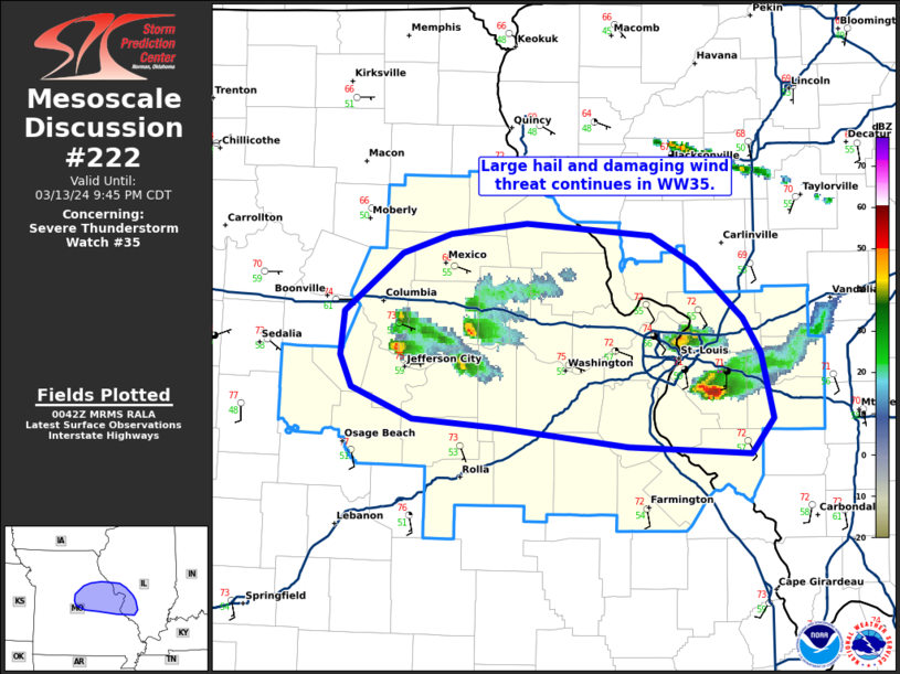
VALID 140155Z - 140240Z
SEVERE WEATHER THREAT CONTINUES RIGHT OF A LINE FROM 20 WSW MVN
TO 35 WSW JEF TO 30 E SZL.
FOR ADDITIONAL INFORMATION SEE MESOSCALE DISCUSSION 222
..THORNTON..03/14/24
ATTN...WFO...LSX...SGF...
&&
STATUS REPORT FOR WS 35
SEVERE WEATHER THREAT CONTINUES FOR THE FOLLOWING AREAS
ILC005-013-027-083-119-133-163-189-140240-
IL
. ILLINOIS COUNTIES INCLUDED ARE
BOND CALHOUN CLINTON
JERSEY MADISON MONROE
ST. CLAIR WASHINGTON
$$
MOC007-019-027-051-071-073-099-113-135-137-139-151-163-173-183-
189-219-510-140240-
MO
. MISSOURI COUNTIES INCLUDED ARE
AUDRAIN BOONE CALLAWAY
COLE FRANKLIN GASCONADE
JEFFERSON LINCOLN MONITEAU
MONROE MONTGOMERY OSAGE
PIKE RALLS ST. CHARLES
ST. LOUIS WARREN
MISSOURI INDEPENDENT CITIES INCLUDED ARE
ST. LOUIS CITY
$$
THE WATCH STATUS MESSAGE IS FOR GUIDANCE PURPOSES ONLY. PLEASE
REFER TO WATCH COUNTY NOTIFICATION STATEMENTS FOR OFFICIAL
INFORMATION ON COUNTIES...INDEPENDENT CITIES AND MARINE ZONES
CLEARED FROM SEVERE THUNDERSTORM AND TORNADO WATCHES.
$$
STATUS REPORT #3 ON WW 35
VALID 140050Z - 140140Z
SEVERE WEATHER THREAT CONTINUES RIGHT OF A LINE FROM 30 N MDH TO
35 WSW JEF TO 30 E SZL.
FOR ADDITIONAL INFORMATION SEE MESOSCALE DISCUSSION 222
..THORNTON..03/14/24
ATTN...WFO...LSX...SGF...
&&
STATUS REPORT FOR WS 35
SEVERE WEATHER THREAT CONTINUES FOR THE FOLLOWING AREAS
ILC005-013-027-083-119-133-163-189-140140-
IL
. ILLINOIS COUNTIES INCLUDED ARE
BOND CALHOUN CLINTON
JERSEY MADISON MONROE
ST. CLAIR WASHINGTON
$$
MOC007-019-027-051-071-073-099-113-135-137-139-151-163-173-183-
189-219-510-140140-
MO
. MISSOURI COUNTIES INCLUDED ARE
AUDRAIN BOONE CALLAWAY
COLE FRANKLIN GASCONADE
JEFFERSON LINCOLN MONITEAU
MONROE MONTGOMERY OSAGE
PIKE RALLS ST. CHARLES
ST. LOUIS WARREN
MISSOURI INDEPENDENT CITIES INCLUDED ARE
ST. LOUIS CITY
$$
THE WATCH STATUS MESSAGE IS FOR GUIDANCE PURPOSES ONLY. PLEASE
REFER TO WATCH COUNTY NOTIFICATION STATEMENTS FOR OFFICIAL
INFORMATION ON COUNTIES...INDEPENDENT CITIES AND MARINE ZONES
CLEARED FROM SEVERE THUNDERSTORM AND TORNADO WATCHES.
$$
STATUS REPORT #2 ON WW 35
VALID 132340Z - 140040Z
THE SEVERE WEATHER THREAT CONTINUES ACROSS THE ENTIRE WATCH AREA.
..THORNTON..03/13/24
ATTN...WFO...LSX...SGF...
&&
STATUS REPORT FOR WS 35
SEVERE WEATHER THREAT CONTINUES FOR THE FOLLOWING AREAS
ILC005-013-027-083-119-133-157-163-189-140040-
IL
. ILLINOIS COUNTIES INCLUDED ARE
BOND CALHOUN CLINTON
JERSEY MADISON MONROE
RANDOLPH ST. CLAIR WASHINGTON
$$
MOC007-019-027-051-055-071-073-099-113-125-131-135-137-139-141-
151-161-163-173-183-186-187-189-219-221-510-140040-
MO
. MISSOURI COUNTIES INCLUDED ARE
AUDRAIN BOONE CALLAWAY
COLE CRAWFORD FRANKLIN
GASCONADE JEFFERSON LINCOLN
MARIES MILLER MONITEAU
MONROE MONTGOMERY MORGAN
OSAGE PHELPS PIKE
RALLS ST. CHARLES STE. GENEVIEVE
ST. FRANCOIS ST. LOUIS WARREN
WASHINGTON
MISSOURI INDEPENDENT CITIES INCLUDED ARE
ST. LOUIS CITY
$$
THE WATCH STATUS MESSAGE IS FOR GUIDANCE PURPOSES ONLY. PLEASE
REFER TO WATCH COUNTY NOTIFICATION STATEMENTS FOR OFFICIAL
INFORMATION ON COUNTIES...INDEPENDENT CITIES AND MARINE ZONES
CLEARED FROM SEVERE THUNDERSTORM AND TORNADO WATCHES.
$$
STATUS REPORT #1 ON WW 35
VALID 132235Z - 132340Z
THE SEVERE WEATHER THREAT CONTINUES ACROSS THE ENTIRE WATCH AREA.
..THORNTON..03/13/24
ATTN...WFO...LSX...SGF...
&&
STATUS REPORT FOR WS 35
SEVERE WEATHER THREAT CONTINUES FOR THE FOLLOWING AREAS
ILC005-013-027-083-119-133-157-163-189-132340-
IL
. ILLINOIS COUNTIES INCLUDED ARE
BOND CALHOUN CLINTON
JERSEY MADISON MONROE
RANDOLPH ST. CLAIR WASHINGTON
$$
MOC007-019-027-051-055-071-073-099-113-125-131-135-137-139-141-
151-161-163-173-183-186-187-189-219-221-510-132340-
MO
. MISSOURI COUNTIES INCLUDED ARE
AUDRAIN BOONE CALLAWAY
COLE CRAWFORD FRANKLIN
GASCONADE JEFFERSON LINCOLN
MARIES MILLER MONITEAU
MONROE MONTGOMERY MORGAN
OSAGE PHELPS PIKE
RALLS ST. CHARLES STE. GENEVIEVE
ST. FRANCOIS ST. LOUIS WARREN
WASHINGTON
MISSOURI INDEPENDENT CITIES INCLUDED ARE
ST. LOUIS CITY
$$
THE WATCH STATUS MESSAGE IS FOR GUIDANCE PURPOSES ONLY. PLEASE
REFER TO WATCH COUNTY NOTIFICATION STATEMENTS FOR OFFICIAL
INFORMATION ON COUNTIES...INDEPENDENT CITIES AND MARINE ZONES
CLEARED FROM SEVERE THUNDERSTORM AND TORNADO WATCHES.
$$
Note:
Click for Complete Product Text.
Tornadoes
Probability of 2 or more tornadoes
|
Low (20%)
|
Probability of 1 or more strong (EF2-EF5) tornadoes
|
Low (5%)
|
Wind
Probability of 10 or more severe wind events
|
Mod (30%)
|
Probability of 1 or more wind events > 65 knots
|
Low (20%)
|
Hail
Probability of 10 or more severe hail events
|
Mod (60%)
|
Probability of 1 or more hailstones > 2 inches
|
Mod (30%)
|
Combined Severe Hail/Wind
Probability of 6 or more combined severe hail/wind events
|
High (80%)
|
For each watch, probabilities for particular events inside the watch
(listed above in each table) are determined by the issuing forecaster.
The "Low" category contains probability values ranging from less than 2%
to 20% (EF2-EF5 tornadoes), less than 5% to 20% (all other probabilities),
"Moderate" from 30% to 60%, and "High" from 70% to greater than 95%.
High values are bolded and lighter in color to provide awareness of
an increased threat for a particular event.


 @NWSSPC