Note:
The expiration time in the watch graphic is amended if the watch is
replaced, cancelled or extended.
Note:
Note:
The expiration time in the watch graphic is amended if the watch is
replaced, cancelled or extended.
Note: Click for
Watch Status Reports.
   SEL4

   URGENT - IMMEDIATE BROADCAST REQUESTED
   Tornado Watch Number 34
   NWS Storm Prediction Center Norman OK
   640 AM EST Sat Mar 9 2024

   The NWS Storm Prediction Center has issued a

   * Tornado Watch for portions of
     Central and eastern Florida Panhandle
     Southern Georgia
     Coastal Waters

   * Effective this Saturday morning and afternoon from 640 AM until
     200 PM EST.

   * Primary threats include...
     A few tornadoes possible
     Scattered damaging wind gusts to 70 mph possible
     Isolated large hail events to 1.5 inches in diameter possible

   SUMMARY...A band of strong to occasionally severe thunderstorms will
   shift eastward across the watch area through midday, in a
   destabilizing environment, while embedded cells pose a threat for
   damaging to severe gusts and a few tornadoes.

   The tornado watch area is approximately along and 50 statute miles
   either side of a line from 5 miles south of Panama City FL to 5
   miles northeast of Savannah GA. For a complete depiction of the
   watch see the associated watch outline update (WOUS64 KWNS WOU4).

   PRECAUTIONARY/PREPAREDNESS ACTIONS...

   REMEMBER...A Tornado Watch means conditions are favorable for
   tornadoes and severe thunderstorms in and close to the watch
   area. Persons in these areas should be on the lookout for
   threatening weather conditions and listen for later statements
   and possible warnings.

   &&

   OTHER WATCH INFORMATION...This tornado watch replaces tornado
   watch number 33. Watch number 33 will not be in effect after 640
   AM EST.

   AVIATION...Tornadoes and a few severe thunderstorms with hail
   surface and aloft to 1.5 inches. Extreme turbulence and surface wind
   gusts to 60 knots. A few cumulonimbi with maximum tops to 450. Mean
   storm motion vector 24040.

   ...Edwards
 Note:
The Aviation Watch (SAW) product is an approximation to the watch area.
The actual watch is depicted by the shaded areas.
Note:
The Aviation Watch (SAW) product is an approximation to the watch area.
The actual watch is depicted by the shaded areas.
   SAW4
   WW 34 TORNADO FL GA CW 091140Z - 091900Z
   AXIS..50 STATUTE MILES EITHER SIDE OF LINE..
   5S PFN/PANAMA CITY FL/ - 5NE SAV/SAVANNAH GA/
   ..AVIATION COORDS.. 45NM EITHER SIDE /66SE CEW - 2NW SAV/
   HAIL SURFACE AND ALOFT..1.5 INCHES. WIND GUSTS..60 KNOTS.
   MAX TOPS TO 450. MEAN STORM MOTION VECTOR 24040.

   REPLACES WW 33..AL FL GA CW

   LAT...LON 30818603 32848149 31528079 29498534

   THIS IS AN APPROXIMATION TO THE WATCH AREA.  FOR A
   COMPLETE DEPICTION OF THE WATCH SEE WOUS64 KWNS
   FOR WOU4.
Watch 34 Status Report Messages:
STATUS REPORT #5 ON WW 34
VALID 091805Z - 091940Z
SEVERE WEATHER THREAT CONTINUES RIGHT OF A LINE FROM 40 SSW PFN
TO 25 WSW SAV TO 55 ESE SAV.
DEPENDING ON CONVECTIVE TRENDS...WW 34 MAY BE EXTENDED IN
AREA/TIME PRIOR TO 19Z EXPIRATION.
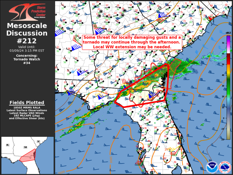
FOR ADDITIONAL INFORMATION SEE MESOSCALE DISCUSSION 211
..DEAN..03/09/24
ATTN...WFO...TAE...JAX...CHS...FFC...
&&
STATUS REPORT FOR WT 34
SEVERE WEATHER THREAT CONTINUES FOR THE FOLLOWING AREAS
FLC037-047-065-079-123-129-091940-
FL
. FLORIDA COUNTIES INCLUDED ARE
FRANKLIN HAMILTON JEFFERSON
MADISON TAYLOR WAKULLA
$$
GAC025-039-049-065-101-127-179-183-191-229-299-305-091940-
GA
. GEORGIA COUNTIES INCLUDED ARE
BRANTLEY CAMDEN CHARLTON
CLINCH ECHOLS GLYNN
LIBERTY LONG MCINTOSH
PIERCE WARE WAYNE
$$
AMZ354-450-GMZ730-752-755-091940-
CW
. ADJACENT COASTAL WATERS INCLUDED ARE
COASTAL WATERS FROM SAVANNAH GA TO ALTAMAHA SOUND GA OUT 20 NM
...INCLUDING GRAYS REEF NATIONAL MARINE SANCTUARY
COASTAL WATERS FROM ALTAMAHA SOUND TO FERNANDINA BEACH FL OUT 20
NM
APALACHEE BAY OR COASTAL WATERS FROM KEATON BEACH TO OCHLOCKONEE
RIVER FL OUT TO 20 NM
COASTAL WATERS FROM MEXICO BEACH TO APALACHICOLA OUT 20 NM
COASTAL WATERS FROM OCHLOCKONEE RIVER TO APALACHICOLA FL OUT TO
20 NM
$$
THE WATCH STATUS MESSAGE IS FOR GUIDANCE PURPOSES ONLY. PLEASE
REFER TO WATCH COUNTY NOTIFICATION STATEMENTS FOR OFFICIAL
INFORMATION ON COUNTIES...INDEPENDENT CITIES AND MARINE ZONES
CLEARED FROM SEVERE THUNDERSTORM AND TORNADO WATCHES.
$$
STATUS REPORT #4 ON WW 34
VALID 091645Z - 091740Z
SEVERE WEATHER THREAT CONTINUES RIGHT OF A LINE FROM 25 SSW PFN
TO 25 N VLD TO 20 NE SAV.
FOR ADDITIONAL INFORMATION SEE MESOSCALE DISCUSSION 211
..DEAN..03/09/24
ATTN...WFO...TAE...JAX...CHS...FFC...
&&
STATUS REPORT FOR WT 34
SEVERE WEATHER THREAT CONTINUES FOR THE FOLLOWING AREAS
FLC005-013-037-039-045-047-065-073-077-079-123-129-091740-
FL
. FLORIDA COUNTIES INCLUDED ARE
BAY CALHOUN FRANKLIN
GADSDEN GULF HAMILTON
JEFFERSON LEON LIBERTY
MADISON TAYLOR WAKULLA
$$
GAC003-019-025-027-029-039-049-051-065-101-127-173-179-183-185-
191-229-275-299-305-091740-
GA
. GEORGIA COUNTIES INCLUDED ARE
ATKINSON BERRIEN BRANTLEY
BROOKS BRYAN CAMDEN
CHARLTON CHATHAM CLINCH
ECHOLS GLYNN LANIER
LIBERTY LONG LOWNDES
MCINTOSH PIERCE THOMAS
WARE WAYNE
$$
AMZ354-450-GMZ730-750-752-755-091740-
CW
. ADJACENT COASTAL WATERS INCLUDED ARE
COASTAL WATERS FROM SAVANNAH GA TO ALTAMAHA SOUND GA OUT 20 NM
...INCLUDING GRAYS REEF NATIONAL MARINE SANCTUARY
COASTAL WATERS FROM ALTAMAHA SOUND TO FERNANDINA BEACH FL OUT 20
NM
APALACHEE BAY OR COASTAL WATERS FROM KEATON BEACH TO OCHLOCKONEE
RIVER FL OUT TO 20 NM
COASTAL WATERS FROM OKALOOSA-WALTON COUNTY LINE TO MEXICO BEACH
OUT 20 NM
COASTAL WATERS FROM MEXICO BEACH TO APALACHICOLA OUT 20 NM
COASTAL WATERS FROM OCHLOCKONEE RIVER TO APALACHICOLA FL OUT TO
20 NM
$$
THE WATCH STATUS MESSAGE IS FOR GUIDANCE PURPOSES ONLY. PLEASE
REFER TO WATCH COUNTY NOTIFICATION STATEMENTS FOR OFFICIAL
INFORMATION ON COUNTIES...INDEPENDENT CITIES AND MARINE ZONES
CLEARED FROM SEVERE THUNDERSTORM AND TORNADO WATCHES.
$$
STATUS REPORT #3 ON WW 34
VALID 091530Z - 091640Z
SEVERE WEATHER THREAT CONTINUES RIGHT OF A LINE FROM 30 SW PFN TO
20 NE SAV.
..DEAN..03/09/24
ATTN...WFO...TAE...JAX...CHS...FFC...
&&
STATUS REPORT FOR WT 34
SEVERE WEATHER THREAT CONTINUES FOR THE FOLLOWING AREAS
FLC005-013-037-039-045-047-065-073-077-079-123-129-091640-
FL
. FLORIDA COUNTIES INCLUDED ARE
BAY CALHOUN FRANKLIN
GADSDEN GULF HAMILTON
JEFFERSON LEON LIBERTY
MADISON TAYLOR WAKULLA
$$
GAC003-005-019-025-027-029-039-049-051-065-075-101-127-173-179-
183-185-191-229-275-299-305-091640-
GA
. GEORGIA COUNTIES INCLUDED ARE
ATKINSON BACON BERRIEN
BRANTLEY BROOKS BRYAN
CAMDEN CHARLTON CHATHAM
CLINCH COOK ECHOLS
GLYNN LANIER LIBERTY
LONG LOWNDES MCINTOSH
PIERCE THOMAS WARE
WAYNE
$$
AMZ354-450-GMZ730-750-752-755-091640-
CW
. ADJACENT COASTAL WATERS INCLUDED ARE
COASTAL WATERS FROM SAVANNAH GA TO ALTAMAHA SOUND GA OUT 20 NM
...INCLUDING GRAYS REEF NATIONAL MARINE SANCTUARY
COASTAL WATERS FROM ALTAMAHA SOUND TO FERNANDINA BEACH FL OUT 20
NM
APALACHEE BAY OR COASTAL WATERS FROM KEATON BEACH TO OCHLOCKONEE
RIVER FL OUT TO 20 NM
COASTAL WATERS FROM OKALOOSA-WALTON COUNTY LINE TO MEXICO BEACH
OUT 20 NM
COASTAL WATERS FROM MEXICO BEACH TO APALACHICOLA OUT 20 NM
COASTAL WATERS FROM OCHLOCKONEE RIVER TO APALACHICOLA FL OUT TO
20 NM
$$
THE WATCH STATUS MESSAGE IS FOR GUIDANCE PURPOSES ONLY. PLEASE
REFER TO WATCH COUNTY NOTIFICATION STATEMENTS FOR OFFICIAL
INFORMATION ON COUNTIES...INDEPENDENT CITIES AND MARINE ZONES
CLEARED FROM SEVERE THUNDERSTORM AND TORNADO WATCHES.
$$
STATUS REPORT #2 ON WW 34
VALID 091440Z - 091540Z
SEVERE WEATHER THREAT CONTINUES RIGHT OF A LINE FROM 35 WSW PFN
TO 25 NNE SAV.
..DEAN..03/09/24
ATTN...WFO...TAE...JAX...CHS...FFC...
&&
STATUS REPORT FOR WT 34
SEVERE WEATHER THREAT CONTINUES FOR THE FOLLOWING AREAS
FLC005-013-037-039-045-047-065-073-077-079-123-129-091540-
FL
. FLORIDA COUNTIES INCLUDED ARE
BAY CALHOUN FRANKLIN
GADSDEN GULF HAMILTON
JEFFERSON LEON LIBERTY
MADISON TAYLOR WAKULLA
$$
GAC001-003-005-019-025-027-029-039-049-051-065-069-071-075-101-
127-131-173-179-183-185-191-229-267-275-299-305-091540-
GA
. GEORGIA COUNTIES INCLUDED ARE
APPLING ATKINSON BACON
BERRIEN BRANTLEY BROOKS
BRYAN CAMDEN CHARLTON
CHATHAM CLINCH COFFEE
COLQUITT COOK ECHOLS
GLYNN GRADY LANIER
LIBERTY LONG LOWNDES
MCINTOSH PIERCE TATTNALL
THOMAS WARE WAYNE
$$
AMZ354-450-GMZ730-750-752-755-091540-
CW
. ADJACENT COASTAL WATERS INCLUDED ARE
COASTAL WATERS FROM SAVANNAH GA TO ALTAMAHA SOUND GA OUT 20 NM
...INCLUDING GRAYS REEF NATIONAL MARINE SANCTUARY
COASTAL WATERS FROM ALTAMAHA SOUND TO FERNANDINA BEACH FL OUT 20
NM
APALACHEE BAY OR COASTAL WATERS FROM KEATON BEACH TO OCHLOCKONEE
RIVER FL OUT TO 20 NM
COASTAL WATERS FROM OKALOOSA-WALTON COUNTY LINE TO MEXICO BEACH
OUT 20 NM
COASTAL WATERS FROM MEXICO BEACH TO APALACHICOLA OUT 20 NM
COASTAL WATERS FROM OCHLOCKONEE RIVER TO APALACHICOLA FL OUT TO
20 NM
$$
THE WATCH STATUS MESSAGE IS FOR GUIDANCE PURPOSES ONLY. PLEASE
REFER TO WATCH COUNTY NOTIFICATION STATEMENTS FOR OFFICIAL
INFORMATION ON COUNTIES...INDEPENDENT CITIES AND MARINE ZONES
CLEARED FROM SEVERE THUNDERSTORM AND TORNADO WATCHES.
$$
STATUS REPORT #1 ON WW 34
VALID 091320Z - 091440Z
SEVERE WEATHER THREAT CONTINUES RIGHT OF A LINE FROM 20 W PFN TO
10 SW MAI TO 25 ENE MAI TO 25 SSW ABY TO 20 N MGR TO 40 NE MGR TO
50 WNW AYS TO 45 SW VDI TO 25 SW VDI TO 10 S VDI TO 20 NNE VDI TO
30 SSW AGS.
..JEWELL..03/09/24
ATTN...WFO...TAE...JAX...CHS...FFC...
&&
STATUS REPORT FOR WT 34
SEVERE WEATHER THREAT CONTINUES FOR THE FOLLOWING AREAS
FLC005-013-037-039-045-047-063-065-073-077-079-123-129-091440-
FL
. FLORIDA COUNTIES INCLUDED ARE
BAY CALHOUN FRANKLIN
GADSDEN GULF HAMILTON
JACKSON JEFFERSON LEON
LIBERTY MADISON TAYLOR
WAKULLA
$$
GAC001-003-005-019-025-027-029-031-039-043-049-051-065-069-071-
075-087-101-103-109-127-131-161-165-173-179-183-185-191-205-229-
251-253-267-275-277-279-299-305-091440-
GA
. GEORGIA COUNTIES INCLUDED ARE
APPLING ATKINSON BACON
BERRIEN BRANTLEY BROOKS
BRYAN BULLOCH CAMDEN
CANDLER CHARLTON CHATHAM
CLINCH COFFEE COLQUITT
COOK DECATUR ECHOLS
EFFINGHAM EVANS GLYNN
GRADY JEFF DAVIS JENKINS
LANIER LIBERTY LONG
LOWNDES MCINTOSH MITCHELL
PIERCE SCREVEN SEMINOLE
TATTNALL THOMAS TIFT
TOOMBS WARE WAYNE
$$
AMZ354-450-GMZ730-750-752-755-091440-
CW
. ADJACENT COASTAL WATERS INCLUDED ARE
COASTAL WATERS FROM SAVANNAH GA TO ALTAMAHA SOUND GA OUT 20 NM
...INCLUDING GRAYS REEF NATIONAL MARINE SANCTUARY
COASTAL WATERS FROM ALTAMAHA SOUND TO FERNANDINA BEACH FL OUT 20
NM
APALACHEE BAY OR COASTAL WATERS FROM KEATON BEACH TO OCHLOCKONEE
RIVER FL OUT TO 20 NM
COASTAL WATERS FROM OKALOOSA-WALTON COUNTY LINE TO MEXICO BEACH
OUT 20 NM
COASTAL WATERS FROM MEXICO BEACH TO APALACHICOLA OUT 20 NM
COASTAL WATERS FROM OCHLOCKONEE RIVER TO APALACHICOLA FL OUT TO
20 NM
$$
THE WATCH STATUS MESSAGE IS FOR GUIDANCE PURPOSES ONLY. PLEASE
REFER TO WATCH COUNTY NOTIFICATION STATEMENTS FOR OFFICIAL
INFORMATION ON COUNTIES...INDEPENDENT CITIES AND MARINE ZONES
CLEARED FROM SEVERE THUNDERSTORM AND TORNADO WATCHES.
$$
Note:
Click for Complete Product Text.
Tornadoes
Probability of 2 or more tornadoes
|
Mod (50%)
|
Probability of 1 or more strong (EF2-EF5) tornadoes
|
Low (20%)
|
Wind
Probability of 10 or more severe wind events
|
Mod (40%)
|
Probability of 1 or more wind events > 65 knots
|
Low (20%)
|
Hail
Probability of 10 or more severe hail events
|
Low (20%)
|
Probability of 1 or more hailstones > 2 inches
|
Low (10%)
|
Combined Severe Hail/Wind
Probability of 6 or more combined severe hail/wind events
|
Mod (60%)
|
For each watch, probabilities for particular events inside the watch
(listed above in each table) are determined by the issuing forecaster.
The "Low" category contains probability values ranging from less than 2%
to 20% (EF2-EF5 tornadoes), less than 5% to 20% (all other probabilities),
"Moderate" from 30% to 60%, and "High" from 70% to greater than 95%.
High values are bolded and lighter in color to provide awareness of
an increased threat for a particular event.


 @NWSSPC