 Note:
The expiration time in the watch graphic is amended if the watch is
replaced, cancelled or extended.
Note:
Note:
The expiration time in the watch graphic is amended if the watch is
replaced, cancelled or extended.
Note: Click for
Watch Status Reports.
SEL4
URGENT - IMMEDIATE BROADCAST REQUESTED
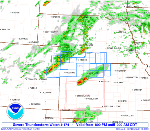
Severe Thunderstorm Watch Number 174
NWS Storm Prediction Center Norman OK
800 PM CDT Wed May 1 2024
The NWS Storm Prediction Center has issued a
* Severe Thunderstorm Watch for portions of
Northeast Colorado
Northwest and North-Central Kansas
Southwest Nebraska
* Effective this Wednesday night and Thursday morning from 800 PM
until 200 AM CDT.
* Primary threats include...
Scattered large hail events to 1.5 inches in diameter possible
Isolated damaging wind gusts to 70 mph possible
A tornado or two possible
SUMMARY...Severe storms are expected to further develop from
northeast Colorado into southwest Nebraska and northwest Kansas,
while additional area of storms could move into north-central
Kansas. Large hail should be the most common severe hazard, but
locally damaging gusts are possible and some tornado risk may exist
across north-central Kansas.
The severe thunderstorm watch area is approximately along and 50
statute miles north and south of a line from 45 miles north
northwest of Burlington CO to 45 miles south of Hastings NE. For a
complete depiction of the watch see the associated watch outline
update (WOUS64 KWNS WOU4).
PRECAUTIONARY/PREPAREDNESS ACTIONS...
REMEMBER...A Severe Thunderstorm Watch means conditions are
favorable for severe thunderstorms in and close to the watch area.
Persons in these areas should be on the lookout for threatening
weather conditions and listen for later statements and possible
warnings. Severe thunderstorms can and occasionally do produce
tornadoes.
&&
OTHER WATCH INFORMATION...CONTINUE...WW 170...WW 171...WW
172...WW 173...
AVIATION...A few severe thunderstorms with hail surface and aloft to
1.5 inches. Extreme turbulence and surface wind gusts to 60 knots. A
few cumulonimbi with maximum tops to 500. Mean storm motion vector
25025.
...Guyer
   SEL4

   URGENT - IMMEDIATE BROADCAST REQUESTED
   Severe Thunderstorm Watch Number 174
   NWS Storm Prediction Center Norman OK
   800 PM CDT Wed May 1 2024

   The NWS Storm Prediction Center has issued a

   * Severe Thunderstorm Watch for portions of
     Northeast Colorado
     Northwest and North-Central Kansas
     Southwest Nebraska

   * Effective this Wednesday night and Thursday morning from 800 PM
     until 200 AM CDT.

   * Primary threats include...
     Scattered large hail events to 1.5 inches in diameter possible
     Isolated damaging wind gusts to 70 mph possible
     A tornado or two possible

   SUMMARY...Severe storms are expected to further develop from
   northeast Colorado into southwest Nebraska and northwest Kansas,
   while additional area of storms could move into north-central
   Kansas. Large hail should be the most common severe hazard, but
   locally damaging gusts are possible and some tornado risk may exist
   across north-central Kansas.

   The severe thunderstorm watch area is approximately along and 50
   statute miles north and south of a line from 45 miles north
   northwest of Burlington CO to 45 miles south of Hastings NE. For a
   complete depiction of the watch see the associated watch outline
   update (WOUS64 KWNS WOU4).

   PRECAUTIONARY/PREPAREDNESS ACTIONS...

   REMEMBER...A Severe Thunderstorm Watch means conditions are
   favorable for severe thunderstorms in and close to the watch area.
   Persons in these areas should be on the lookout for threatening
   weather conditions and listen for later statements and possible
   warnings. Severe thunderstorms can and occasionally do produce
   tornadoes.

   &&

   OTHER WATCH INFORMATION...CONTINUE...WW 170...WW 171...WW
   172...WW 173...

   AVIATION...A few severe thunderstorms with hail surface and aloft to
   1.5 inches. Extreme turbulence and surface wind gusts to 60 knots. A
   few cumulonimbi with maximum tops to 500. Mean storm motion vector
   25025.

   ...Guyer
 Note:
The Aviation Watch (SAW) product is an approximation to the watch area.
The actual watch is depicted by the shaded areas.
Note:
The Aviation Watch (SAW) product is an approximation to the watch area.
The actual watch is depicted by the shaded areas.
   SAW4
   WW 174 SEVERE TSTM CO KS NE 020100Z - 020700Z
   AXIS..50 STATUTE MILES NORTH AND SOUTH OF LINE..
   45NNW ITR/BURLINGTON CO/ - 45S HSI/HASTINGS NE/
   ..AVIATION COORDS.. 45NM N/S /33SE AKO - 72NNW SLN/
   HAIL SURFACE AND ALOFT..1.5 INCHES. WIND GUSTS..60 KNOTS.
   MAX TOPS TO 500. MEAN STORM MOTION VECTOR 25025.

   LAT...LON 40560260 40669843 39239843 39120260

   THIS IS AN APPROXIMATION TO THE WATCH AREA.  FOR A
   COMPLETE DEPICTION OF THE WATCH SEE WOUS64 KWNS
   FOR WOU4.
Watch 174 Status Report Messages:
STATUS REPORT #1 ON WW 174

VALID 020405Z - 020540Z

SEVERE WEATHER THREAT CONTINUES RIGHT OF A LINE FROM 20 SW ITR TO
45 NE MCK.

FOR ADDITIONAL INFORMATION SEE MESOSCALE DISCUSSION 597

..MOSIER..05/02/24

ATTN...WFO...GLD...GID...LBF...

&&

STATUS REPORT FOR WS 174

SEVERE WEATHER THREAT CONTINUES FOR THE FOLLOWING AREAS

KSC039-065-089-123-137-141-147-153-163-179-181-183-193-020540-

KS
.    KANSAS COUNTIES INCLUDED ARE

DECATUR 	     GRAHAM		 JEWELL
MITCHELL	     NORTON		 OSBORNE
PHILLIPS	     RAWLINS		 ROOKS
SHERIDAN	     SHERMAN		 SMITH
THOMAS
$$


NEC001-061-065-073-083-099-137-181-020540-

NE
.    NEBRASKA COUNTIES INCLUDED ARE

ADAMS		     FRANKLIN		 FURNAS
GOSPER		     HARLAN		 KEARNEY
PHELPS		     WEBSTER
$$


THE WATCH STATUS MESSAGE IS FOR GUIDANCE PURPOSES ONLY.  PLEASE
REFER TO WATCH COUNTY NOTIFICATION STATEMENTS FOR OFFICIAL
INFORMATION ON COUNTIES...INDEPENDENT CITIES AND MARINE ZONES
CLEARED FROM SEVERE THUNDERSTORM AND TORNADO WATCHES.
$$
Note:
Click for Complete Product Text.
Tornadoes
Probability of 2 or more tornadoes
|
Low (20%)
|
Probability of 1 or more strong (EF2-EF5) tornadoes
|
Low (5%)
|
Wind
Probability of 10 or more severe wind events
|
Mod (30%)
|
Probability of 1 or more wind events > 65 knots
|
Low (20%)
|
Hail
Probability of 10 or more severe hail events
|
Mod (50%)
|
Probability of 1 or more hailstones > 2 inches
|
Low (20%)
|
Combined Severe Hail/Wind
Probability of 6 or more combined severe hail/wind events
|
High (80%)
|
For each watch, probabilities for particular events inside the watch
(listed above in each table) are determined by the issuing forecaster.
The "Low" category contains probability values ranging from less than 2%
to 20% (EF2-EF5 tornadoes), less than 5% to 20% (all other probabilities),
"Moderate" from 30% to 60%, and "High" from 70% to greater than 95%.
High values are bolded and lighter in color to provide awareness of
an increased threat for a particular event.


 @NWSSPC


