Note:
The expiration time in the watch graphic is amended if the watch is
replaced, cancelled or extended.
Note:
Note:
The expiration time in the watch graphic is amended if the watch is
replaced, cancelled or extended.
Note: Click for
Watch Status Reports.
SEL2
URGENT - IMMEDIATE BROADCAST REQUESTED
Severe Thunderstorm Watch Number 162
NWS Storm Prediction Center Norman OK
155 AM CDT Mon Apr 29 2024
The NWS Storm Prediction Center has issued a
* Severe Thunderstorm Watch for portions of
South central and southwest Louisiana
Extreme southwest Mississippi
Southeast Texas
Coastal Waters
* Effective this Monday morning from 155 AM until 900 AM CDT.
* Primary threats include...
Scattered damaging wind gusts to 65 mph possible
Isolated large hail events to 1 inch in diameter possible
A tornado or two possible
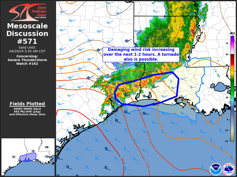
SUMMARY...A large convective cluster will continue to develop slowly
southeastward through the early morning hours across southeast Texas
and southwest/south central Louisiana. Embedded bowing segments
will pose the threat for occasional damaging winds up to 65 mph, and
the stronger embedded cells could produce isolated large hail near 1
inch in diameter. An isolated tornado or two may also occur with
circulations embedded in the larger band of storms.
The severe thunderstorm watch area is approximately along and 55
statute miles north and south of a line from 60 miles west northwest
of Port Arthur TX to 50 miles east of Lafayette LA. For a complete
depiction of the watch see the associated watch outline update
(WOUS64 KWNS WOU2).
PRECAUTIONARY/PREPAREDNESS ACTIONS...
REMEMBER...A Severe Thunderstorm Watch means conditions are
favorable for severe thunderstorms in and close to the watch area.
Persons in these areas should be on the lookout for threatening
weather conditions and listen for later statements and possible
warnings. Severe thunderstorms can and occasionally do produce
tornadoes.
&&
OTHER WATCH INFORMATION...CONTINUE...WW 160...
AVIATION...A few severe thunderstorms with hail surface and aloft to
1 inch. Extreme turbulence and surface wind gusts to 55 knots. A few
cumulonimbi with maximum tops to 550. Mean storm motion vector
30015.
...Thompson

   SEL2

   URGENT - IMMEDIATE BROADCAST REQUESTED
   Severe Thunderstorm Watch Number 162
   NWS Storm Prediction Center Norman OK
   155 AM CDT Mon Apr 29 2024

   The NWS Storm Prediction Center has issued a

   * Severe Thunderstorm Watch for portions of
     South central and southwest Louisiana
     Extreme southwest Mississippi
     Southeast Texas
     Coastal Waters

   * Effective this Monday morning from 155 AM until 900 AM CDT.

   * Primary threats include...
     Scattered damaging wind gusts to 65 mph possible
     Isolated large hail events to 1 inch in diameter possible
     A tornado or two possible

   SUMMARY...A large convective cluster will continue to develop slowly
   southeastward through the early morning hours across southeast Texas
   and southwest/south central Louisiana.  Embedded bowing segments
   will pose the threat for occasional damaging winds up to 65 mph, and
   the stronger embedded cells could produce isolated large hail near 1
   inch in diameter.  An isolated tornado or two may also occur with
   circulations embedded in the larger band of storms.

   The severe thunderstorm watch area is approximately along and 55
   statute miles north and south of a line from 60 miles west northwest
   of Port Arthur TX to 50 miles east of Lafayette LA. For a complete
   depiction of the watch see the associated watch outline update
   (WOUS64 KWNS WOU2).

   PRECAUTIONARY/PREPAREDNESS ACTIONS...

   REMEMBER...A Severe Thunderstorm Watch means conditions are
   favorable for severe thunderstorms in and close to the watch area.
   Persons in these areas should be on the lookout for threatening
   weather conditions and listen for later statements and possible
   warnings. Severe thunderstorms can and occasionally do produce
   tornadoes.

   &&

   OTHER WATCH INFORMATION...CONTINUE...WW 160...

   AVIATION...A few severe thunderstorms with hail surface and aloft to
   1 inch. Extreme turbulence and surface wind gusts to 55 knots. A few
   cumulonimbi with maximum tops to 550. Mean storm motion vector
   30015.

   ...Thompson
 Note:
The Aviation Watch (SAW) product is an approximation to the watch area.
The actual watch is depicted by the shaded areas.
Note:
The Aviation Watch (SAW) product is an approximation to the watch area.
The actual watch is depicted by the shaded areas.
   SAW2
   WW 162 SEVERE TSTM LA MS TX CW 290655Z - 291400Z
   AXIS..55 STATUTE MILES NORTH AND SOUTH OF LINE..
   60WNW BPT/PORT ARTHUR TX/ - 50E LFT/LAFAYETTE LA/
   ..AVIATION COORDS.. 50NM N/S /28NE IAH - 19SSE BTR/
   HAIL SURFACE AND ALOFT..1 INCH. WIND GUSTS..55 KNOTS.
   MAX TOPS TO 550. MEAN STORM MOTION VECTOR 30015.

   LAT...LON 31089495 30999114 29409114 29489495

   THIS IS AN APPROXIMATION TO THE WATCH AREA.  FOR A
   COMPLETE DEPICTION OF THE WATCH SEE WOUS64 KWNS
   FOR WOU2.
Watch 162 Status Report Messages:
STATUS REPORT #6 ON WW 162

VALID 291340Z - 291400Z

SEVERE WEATHER THREAT CONTINUES RIGHT OF A LINE FROM 25 S 7R4 TO
50 E LFT.

REMAINING VALID PORTION OF WW 162 MAY BE ALLOWED TO EXPIRE AT
29/14Z.
..KERR..04/29/24

ATTN...WFO...LCH...LIX...HGX...

&&

STATUS REPORT FOR WS 162

SEVERE WEATHER THREAT CONTINUES FOR THE FOLLOWING AREAS

LAC045-101-291400-

LA
.    LOUISIANA PARISHES INCLUDED ARE

IBERIA		     ST. MARY
$$


GMZ435-436-452-455-291400-

CW

.    ADJACENT COASTAL WATERS INCLUDED ARE

VERMILION BAY


COASTAL WATERS FROM INTRACOASTAL CITY TO CAMERON LA OUT 20 NM

COASTAL WATERS FROM LOWER ATCHAFALAYA RIVER TO INTRACOASTAL CITY
LA OUT 20 NM

$$
THE WATCH STATUS MESSAGE IS FOR GUIDANCE PURPOSES ONLY.  PLEASE
REFER TO WATCH COUNTY NOTIFICATION STATEMENTS FOR OFFICIAL
INFORMATION ON COUNTIES...INDEPENDENT CITIES AND MARINE ZONES
CLEARED FROM SEVERE THUNDERSTORM AND TORNADO WATCHES.
$$

STATUS REPORT #5 ON WW 162

VALID 291245Z - 291340Z

SEVERE WEATHER THREAT CONTINUES RIGHT OF A LINE FROM 50 S LCH TO
5 SSW 7R4 TO 50 ENE LFT TO 35 SSW MCB.

..LEITMAN..04/29/24

ATTN...WFO...LCH...LIX...HGX...

&&

STATUS REPORT FOR WS 162

SEVERE WEATHER THREAT CONTINUES FOR THE FOLLOWING AREAS

LAC033-045-047-099-101-121-291340-

LA
.    LOUISIANA PARISHES INCLUDED ARE

EAST BATON ROUGE     IBERIA		 IBERVILLE
ST. MARTIN	     ST. MARY		 WEST BATON ROUGE
$$


GMZ435-436-452-455-291340-

CW

.    ADJACENT COASTAL WATERS INCLUDED ARE

VERMILION BAY


COASTAL WATERS FROM INTRACOASTAL CITY TO CAMERON LA OUT 20 NM

COASTAL WATERS FROM LOWER ATCHAFALAYA RIVER TO INTRACOASTAL CITY
LA OUT 20 NM

$$
THE WATCH STATUS MESSAGE IS FOR GUIDANCE PURPOSES ONLY.  PLEASE
REFER TO WATCH COUNTY NOTIFICATION STATEMENTS FOR OFFICIAL
INFORMATION ON COUNTIES...INDEPENDENT CITIES AND MARINE ZONES
CLEARED FROM SEVERE THUNDERSTORM AND TORNADO WATCHES.
$$

STATUS REPORT #4 ON WW 162

VALID 291140Z - 291240Z

SEVERE WEATHER THREAT CONTINUES RIGHT OF A LINE FROM 25 ENE GLS
TO 20 SSE LCH TO 30 WNW 7R4 TO 10 WNW LFT TO 45 NNE LFT TO 30 SSE
HEZ.

..LEITMAN..04/29/24

ATTN...WFO...LCH...LIX...HGX...

&&

STATUS REPORT FOR WS 162

SEVERE WEATHER THREAT CONTINUES FOR THE FOLLOWING AREAS

LAC023-033-037-045-047-055-077-099-101-113-121-125-291240-

LA
.    LOUISIANA PARISHES INCLUDED ARE

CAMERON 	     EAST BATON ROUGE	 EAST FELICIANA
IBERIA		     IBERVILLE		 LAFAYETTE
POINTE COUPEE	     ST. MARTIN 	 ST. MARY
VERMILION	     WEST BATON ROUGE	 WEST FELICIANA
$$


MSC005-157-291240-

MS
.    MISSISSIPPI COUNTIES INCLUDED ARE

AMITE		     WILKINSON
$$


GMZ432-435-436-450-452-455-291240-

CW

.    ADJACENT COASTAL WATERS INCLUDED ARE

CALCASIEU LAKE

VERMILION BAY


COASTAL WATERS FROM CAMERON LA TO HIGH ISLAND TX OUT 20 NM

COASTAL WATERS FROM INTRACOASTAL CITY TO CAMERON LA OUT 20 NM

COASTAL WATERS FROM LOWER ATCHAFALAYA RIVER TO INTRACOASTAL CITY
LA OUT 20 NM

$$
THE WATCH STATUS MESSAGE IS FOR GUIDANCE PURPOSES ONLY.  PLEASE
REFER TO WATCH COUNTY NOTIFICATION STATEMENTS FOR OFFICIAL
INFORMATION ON COUNTIES...INDEPENDENT CITIES AND MARINE ZONES
CLEARED FROM SEVERE THUNDERSTORM AND TORNADO WATCHES.
$$

STATUS REPORT #3 ON WW 162

VALID 291040Z - 291140Z

SEVERE WEATHER THREAT CONTINUES RIGHT OF A LINE FROM 15 NNE HOU
TO 20 W LCH TO 25 ENE LCH TO 35 NNW LFT TO 30 SSW HEZ.

..LEITMAN..04/29/24

ATTN...WFO...LCH...LIX...HGX...

&&

STATUS REPORT FOR WS 162

SEVERE WEATHER THREAT CONTINUES FOR THE FOLLOWING AREAS

LAC001-023-033-037-045-047-053-055-077-097-099-101-113-121-125-
291140-

LA
.    LOUISIANA PARISHES INCLUDED ARE

ACADIA		     CAMERON		 EAST BATON ROUGE
EAST FELICIANA	     IBERIA		 IBERVILLE
JEFFERSON DAVIS      LAFAYETTE		 POINTE COUPEE
ST. LANDRY	     ST. MARTIN 	 ST. MARY
VERMILION	     WEST BATON ROUGE	 WEST FELICIANA
$$


MSC005-157-291140-

MS
.    MISSISSIPPI COUNTIES INCLUDED ARE

AMITE		     WILKINSON
$$


TXC071-245-291140-

TX
.    TEXAS COUNTIES INCLUDED ARE

CHAMBERS	     JEFFERSON
$$


GMZ430-432-435-436-450-452-455-291140-

CW

.    ADJACENT COASTAL WATERS INCLUDED ARE

SABINE LAKE

CALCASIEU LAKE

VERMILION BAY


COASTAL WATERS FROM CAMERON LA TO HIGH ISLAND TX OUT 20 NM

COASTAL WATERS FROM INTRACOASTAL CITY TO CAMERON LA OUT 20 NM

COASTAL WATERS FROM LOWER ATCHAFALAYA RIVER TO INTRACOASTAL CITY
LA OUT 20 NM

$$
THE WATCH STATUS MESSAGE IS FOR GUIDANCE PURPOSES ONLY.  PLEASE
REFER TO WATCH COUNTY NOTIFICATION STATEMENTS FOR OFFICIAL
INFORMATION ON COUNTIES...INDEPENDENT CITIES AND MARINE ZONES
CLEARED FROM SEVERE THUNDERSTORM AND TORNADO WATCHES.
$$

STATUS REPORT #2 ON WW 162

VALID 290940Z - 291040Z

SEVERE WEATHER THREAT CONTINUES RIGHT OF A LINE FROM 25 NE HOU TO
20 NE BPT TO 35 SE POE TO 30 E ESF.

..LEITMAN..04/29/24

ATTN...WFO...LCH...LIX...HGX...

&&

STATUS REPORT FOR WS 162

SEVERE WEATHER THREAT CONTINUES FOR THE FOLLOWING AREAS

LAC001-009-019-023-033-037-039-045-047-053-055-077-097-099-101-
113-121-125-291040-

LA
.    LOUISIANA PARISHES INCLUDED ARE

ACADIA		     AVOYELLES		 CALCASIEU
CAMERON 	     EAST BATON ROUGE	 EAST FELICIANA
EVANGELINE	     IBERIA		 IBERVILLE
JEFFERSON DAVIS      LAFAYETTE		 POINTE COUPEE
ST. LANDRY	     ST. MARTIN 	 ST. MARY
VERMILION	     WEST BATON ROUGE	 WEST FELICIANA
$$


MSC005-157-291040-

MS
.    MISSISSIPPI COUNTIES INCLUDED ARE

AMITE		     WILKINSON
$$


TXC071-245-361-291040-

TX
.    TEXAS COUNTIES INCLUDED ARE

CHAMBERS	     JEFFERSON		 ORANGE
$$


GMZ430-432-435-436-450-452-455-291040-

CW

.    ADJACENT COASTAL WATERS INCLUDED ARE

SABINE LAKE

CALCASIEU LAKE

VERMILION BAY


COASTAL WATERS FROM CAMERON LA TO HIGH ISLAND TX OUT 20 NM

COASTAL WATERS FROM INTRACOASTAL CITY TO CAMERON LA OUT 20 NM

COASTAL WATERS FROM LOWER ATCHAFALAYA RIVER TO INTRACOASTAL CITY
LA OUT 20 NM

$$
THE WATCH STATUS MESSAGE IS FOR GUIDANCE PURPOSES ONLY.  PLEASE
REFER TO WATCH COUNTY NOTIFICATION STATEMENTS FOR OFFICIAL
INFORMATION ON COUNTIES...INDEPENDENT CITIES AND MARINE ZONES
CLEARED FROM SEVERE THUNDERSTORM AND TORNADO WATCHES.
$$

STATUS REPORT #1 ON WW 162

VALID 290900Z - 291040Z

SEVERE WEATHER THREAT CONTINUES RIGHT OF A LINE FROM 35 SE UTS TO
30 NNE BPT TO 30 SE POE TO 10 SSE ESF TO 25 ENE ESF.

..LEITMAN..04/29/24

ATTN...WFO...LCH...LIX...HGX...

&&

STATUS REPORT FOR WS 162

SEVERE WEATHER THREAT CONTINUES FOR THE FOLLOWING AREAS

LAC001-003-009-011-019-023-033-037-039-045-047-053-055-077-079-
097-099-101-113-121-125-291040-

LA
.    LOUISIANA PARISHES INCLUDED ARE

ACADIA		     ALLEN		 AVOYELLES
BEAUREGARD	     CALCASIEU		 CAMERON
EAST BATON ROUGE     EAST FELICIANA	 EVANGELINE
IBERIA		     IBERVILLE		 JEFFERSON DAVIS
LAFAYETTE	     POINTE COUPEE	 RAPIDES
ST. LANDRY	     ST. MARTIN 	 ST. MARY
VERMILION	     WEST BATON ROUGE	 WEST FELICIANA
$$


MSC005-157-291040-

MS
.    MISSISSIPPI COUNTIES INCLUDED ARE

AMITE		     WILKINSON
$$


TXC199-245-291-361-291040-

TX
.    TEXAS COUNTIES INCLUDED ARE

HARDIN		     JEFFERSON		 LIBERTY
ORANGE
$$


GMZ430-432-435-436-450-452-455-291040-

CW

.    ADJACENT COASTAL WATERS INCLUDED ARE

SABINE LAKE

CALCASIEU LAKE

VERMILION BAY


COASTAL WATERS FROM CAMERON LA TO HIGH ISLAND TX OUT 20 NM

COASTAL WATERS FROM INTRACOASTAL CITY TO CAMERON LA OUT 20 NM

COASTAL WATERS FROM LOWER ATCHAFALAYA RIVER TO INTRACOASTAL CITY
LA OUT 20 NM

$$
THE WATCH STATUS MESSAGE IS FOR GUIDANCE PURPOSES ONLY.  PLEASE
REFER TO WATCH COUNTY NOTIFICATION STATEMENTS FOR OFFICIAL
INFORMATION ON COUNTIES...INDEPENDENT CITIES AND MARINE ZONES
CLEARED FROM SEVERE THUNDERSTORM AND TORNADO WATCHES.
$$
Note:
Click for Complete Product Text.
Tornadoes
Probability of 2 or more tornadoes
|
Low (20%)
|
Probability of 1 or more strong (EF2-EF5) tornadoes
|
Low (5%)
|
Wind
Probability of 10 or more severe wind events
|
Mod (40%)
|
Probability of 1 or more wind events > 65 knots
|
Low (10%)
|
Hail
Probability of 10 or more severe hail events
|
Low (20%)
|
Probability of 1 or more hailstones > 2 inches
|
Low (10%)
|
Combined Severe Hail/Wind
Probability of 6 or more combined severe hail/wind events
|
Mod (60%)
|
For each watch, probabilities for particular events inside the watch
(listed above in each table) are determined by the issuing forecaster.
The "Low" category contains probability values ranging from less than 2%
to 20% (EF2-EF5 tornadoes), less than 5% to 20% (all other probabilities),
"Moderate" from 30% to 60%, and "High" from 70% to greater than 95%.
High values are bolded and lighter in color to provide awareness of
an increased threat for a particular event.


 @NWSSPC